South Pottstown | |
---|---|
Coordinates: 40°14′11″N75°39′26″W / 40.23639°N 75.65722°W | |
Country | United States |
State | Pennsylvania |
County | Chester |
Township | North Coventry |
Area | |
• Total | 1.6 sq mi (4 km2) |
• Land | 1.5 sq mi (4 km2) |
• Water | 0.1 sq mi (0.3 km2) |
Elevation | 141 ft (43 m) |
Population (2010) | |
• Total | 2,081 |
• Density | 1,300/sq mi (500/km2) |
Time zone | UTC-5 (EST) |
• Summer (DST) | UTC-4 (EDT) |
ZIP code | |
Area code(s) | 610, 484, & 835 |
South Pottstown is a community in North Coventry Township, Chester County in the U.S. state of Pennsylvania. It is defined by the U.S. Census Bureau as a census-designated place (CDP) for statistical purposes and does not have any legal status as a separately incorporated municipality. It is a part of the Pottstown urban area. The population was 2,081 at the 2010 census.
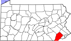
South Pottstown is located at 40°14′11″N75°39′26″W / 40.23639°N 75.65722°W (40.236443, -75.657220). [1]
According to the United States Census Bureau, the CDP has a total area of 1.6 square miles (4.1 km2), of which 1.5 square miles (3.9 km2) is land and 0.1 square miles (0.26 km2), or 4.32%, is water.
South Pottstown is served by east-to-west US 422 and PA 724 as well as north-to-south PA 100 and South Hanover Street. The Coventry Mall is a regional shopping center in South Pottstown, which faces Pottstown across the Schuylkill River on the northern boundary. Its hardiness zone is 7a and the climate is borderline Cfa/Dfa (humid subtropical/hot summer humid continental.) It is served by the Pottstown post office and telephone exchange.
At the 2000 census there were 2,135 people, 997 households, and 528 families living in the CDP. The population density was 1,373.0 inhabitants per square mile (530.1/km2). There were 1,046 housing units at an average density of 672.7 per square mile (259.7/km2). The racial makeup of the CDP was 93.26% White, 3.70% African American, 0.33% Native American, 1.03% Asian, 0.56% from other races, and 1.12% from two or more races. Hispanic or Latino of any race were 1.55%. [2]
There were 997 households, 23.2% had children under the age of 18 living with them, 38.6% were married couples living together, 11.0% had a female householder with no husband present, and 47.0% were non-families. 38.7% of households were made up of individuals, and 11.2% were one person aged 65 or older. The average household size was 2.14 and the average family size was 2.92.
The age distribution was 20.0% under the age of 18, 10.8% from 18 to 24, 33.0% from 25 to 44, 22.8% from 45 to 64, and 13.3% 65 or older. The median age was 36 years. For every 100 females, there were 96.2 males. For every 100 females age 18 and over, there were 98.7 males.
The median household income was $43,634 and the median family income was $59,180. Males had a median income of $36,708 versus $26,404 for females. The per capita income for the CDP was $23,099. About 5.0% of families and 7.7% of the population were below the poverty line, including 6.4% of those under age 18 and none of those age 65 or over.
Pottstown is within the Owen J. Roberts School District. [3] Owen J. Roberts High School is the zoned comprehensive high school.
Lukachukai is a census-designated place (CDP) in Apache County, Arizona, United States. The population was 1,701 at the 2010 census. It is within the Navajo Nation.
Desert Hills is an unincorporated community and census-designated place (CDP) in Mohave County, Arizona, United States. The population was 2,764 at the 2020 census, up from 2,245 at the 2010 census.
Whittingham, also known as Greenbriar at Whittingham, is an unincorporated community and census-designated place (CDP) located within Monroe Township, in Middlesex County, in the U.S. state of New Jersey. As of the 2010 United States Census, the CDP's population was 2,476. The area is focused around the age-restricted gated community of Whittingham.
Flying Hills is a census-designated place (CDP) in Cumru Township, Berks County, Pennsylvania. The population was 2,568 as of the 2010 census.
Shanor-Northvue is a census-designated place (CDP) in Butler County, Pennsylvania, United States. The population was 5,051 at the 2010 census.
Kenilworth is a census-designated place (CDP) in North Coventry Township, Chester County, Pennsylvania, United States. The population was 2,148 at the 2020 census.
Lionville is a census-designated place (CDP) in Uwchlan Township, Chester County, Pennsylvania, United States. The population was 6,189 at the 2010 census. Prior to 2010 the CDP was recorded as Lionville-Marchwood. "Marchwood", however, refers only to the housing development begun in the early 1960s that is located south of the 100-113 intersection.
North Coventry Township is a township in Chester County, Pennsylvania, United States. The population was 7,866 at the 2010 census.
South Coventry Township is a township in Chester County, Pennsylvania, United States. The population was 2,604 at the 2010 census.
Schlusser pronounced (Skloosher) is a census-designated place (CDP) in North Middleton and Middlesex townships, Cumberland County, Pennsylvania, United States. The population was 5,265 at the 2010 census. It is part of the Harrisburg–Carlisle Metropolitan Statistical Area.
Mexico is an unincorporated community and census-designated place (CDP) in Walker Township, Juniata County, Pennsylvania, United States.
Eagleville is a census-designated place (CDP) in Montgomery County, Pennsylvania, United States. The population was 4,800 at the 2010 census. It is within Lower Providence Township.
Halfway House is a census-designated place (CDP) in Montgomery County, Pennsylvania, United States. The population was 2,881 at the 2010 census.
Montgomeryville is a census-designated place (CDP) in Montgomery Township, Montgomery County, Pennsylvania, United States. The population was 12,624 at the 2010 census. According to a 2010 Forbes magazine/Yahoo.com survey, Montgomeryville ranks 5th in America's top 10 affordable suburbs. It is part of the North Penn Valley region that is centered on the borough of Lansdale.
Pottstown is a borough in Montgomery County, Pennsylvania, United States. Pottstown was laid out in 1752–53 and named Pottsgrove in honor of its founder, John Potts. The old name was abandoned at the time of the incorporation as a borough in 1815. In 1888, the limits of the borough were considerably extended. Pottstown is the center of a productive farming and dairying region.
Sanatoga is a community and census-designated place (CDP) that is located in Lower Pottsgrove Township, Montgomery County, Pennsylvania, United States. It is situated immediately east of the borough of Pottstown on U.S. Route 422.
Stowe is a census-designated place (CDP) in West Pottsgrove Township, Montgomery County, Pennsylvania, United States. The population was 3,695 at the 2010 census. It uses the Pottstown ZIP code of 19464.
Trooper is a census-designated place (CDP) in Lower Providence Township, Montgomery County, Pennsylvania, United States. The population was 5,744 at the 2010 census.
Upper Pottsgrove Township is a township in Montgomery County, Pennsylvania, United States. The population was 5,315 at the 2010 census.
Hometown is a village in Rush Township, Schuylkill County, Pennsylvania, United States that sits astride a crossing point between important transportation corridors. The population was 1,399 at the 2000 census, and excepting for the area near the east–west PA 54 running mostly parallel to the tracks of the Reading, Blue Mountain, and Northern Railroad — once the important east-west shortline Nesquehoning & Mahanoy Railroad — and the PA 54 junction with PA 309.