
Mount Columbia is a mountain located in the Winston Churchill Range of the Rocky Mountains. It is the highest point in Alberta, Canada, and is second only to Mount Robson for height and topographical prominence in the Canadian Rockies. It is located on the border between Alberta and British Columbia on the northern edge of the Columbia Icefield. Its highest point, however, lies within Jasper National Park in Alberta.

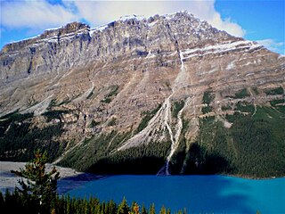
Peyto Peak is a mountain in the Waputik Range, part of the Canadian Rockies in Alberta, Canada. It lies at the north end of the Wapta Icefield, in Banff National Park, about one km (0.6 mi) east of the border with British Columbia and 32 km (20 mi) north of the town of Field. Five kilometres to the northeast lies Bow Pass, one of the high points of the Icefields Parkway. Between the peak and the pass lies picturesque Peyto Lake. Three kilometres southwest of Peyto Peak is Mount Baker, the highest point in the immediate vicinity.

Saint Nicholas Peak is a 2,938-metre (9,639-foot) mountain summit in the Rocky Mountains of Canada. It is located on the Continental Divide, on the Alberta-British Columbia border, in both Banff National Park and Yoho National Park. It lies at the eastern edge of the Wapta Icefield, and is part of the Waputik Mountains which are a sub-range of the Canadian Rockies.

Mount Lyell is a mountain on the Alberta–British Columbia border in western Canada. Comprising five distinct summits, Mount Lyell reaches a height of 3,498 m (11,476 ft). The mountain was named by James Hector in 1858 in recognition of Scottish geologist Sir Charles Lyell.

Popes Peak is a mountain on the border of Alberta and British Columbia in Western Canada, on the Continental Divide of the Americas, part of the Bow Range of the Canadian Rockies between Lake Louise Valley and Cataract Brook, bordering Banff and Yoho national parks.

Mount Balfour is a mountain located on the Continental Divide, part of the border between British Columbia and Alberta, in the Waputik Range in the Park Ranges of the Canadian Rockies. It is the 71st highest peak in Alberta and the 113th highest in British Columbia; it is also the 52nd most prominent in Alberta.
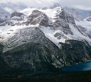
Caldron Peak is a 2,911-metre (9,551 ft) mountain peak of the Waputik Range, located in Alberta, Canada. It is prominently visible from the Peyto Lake Overlook in Banff National Park.

Aiguille Peak is a peak located on the Canadian provincial boundary of Alberta and British Columbia in Banff National Park. It was named in 1915 by Arthur O. Wheeler. "Aiguille" is French for "needle" and is also a mountaineering term for a sharp-ridged summit.
Mistaya Mountain is located on the border of Alberta and British Columbia, on the Continental Divide. It was named in 1918. Mistaya is either the Cree name for "grizzly bear" or is the Stoney word for "much wind".

Mount Habel is a 3,073-metre (10,082-foot) mountain summit located in Banff National Park on the Continental Divide along the border of Alberta and British Columbia in the Waputik Mountains, part of the Canadian Rockies. It was named in 1986 after Jean Habel. Jean Habel was a German geographer who explored the Canadian Rockies and in 1897 was the first to set foot on the Wapta Icefield which surrounds Mount Habel.
Glacier Peak is located on the border of Alberta and British Columbia in the Canadian Rockies. It was named in 1894 by Samuel E.S. Allen in reference to the glacier on the northern side of the mountain.

Wenkchemna Peak is located on the SE ridge coming off of Mount Hungabee on the border of Alberta and British Columbia. It was named in 1894 by Samuel E. S. Allen for the Stoney Indian word for ten.
Boom Mountain is located north of Vermilion Pass on the border of Alberta and British Columbia on the Continental Divide. It was named in 1908 after Boom Lake which is located right under the mountain. When viewed by an Alpine Club of Canada expedition, a buildup of logs on the lake resembled a log boom.
Mount Gloria is located on the border of Alberta and British Columbia on the Continental Divide in Canada. It was named in 1913 by the Interprovincial Boundary Survey after Lake Gloria which lies directly north of the mountain.

Eon Mountain is located on the border of Alberta and British Columbia on the Continental Divide. It is Alberta's 41st-highest peak, and the 53rd-highest peak in British Columbia. It was named in 1901 by James Outram.

Mount Beatty is a mountain located on the border of Alberta and British Columbia on the Continental Divide. It was named in 1924 after David Beatty, a British naval officer of Irish ancestry who commanded ships in the First World War.

Warrior Mountain is located north of Mount Joffre in Height of the Rockies Provincial Park and straddles the Continental Divide marking the Alberta-British Columbia border. It was named in 1917 after HMS Warrior. The first ascent of the mountain was made in 1930 by Kate (Katie) Gardiner and Walter Feuz. The duo also made the first ascents of nearby Mount Sarrail and Mount Lyautey that same year.

Forum Peak is a summit located on the border of Alberta and British Columbia on the Continental Divide. It is the southernmost mountain in the Canadian Rockies, situated only 500 metres north of the Canada–United States border. It was named after Forum Lake below the mountain. It is visible from the end of Highway 5 at Cameron Lake, which is within Waterton Lakes National Park, and the mountain is on the park's southwest border.

Mount Aberdeen is a 3,152-metre (10,341-foot) mountain summit located in the Lake Louise area of Banff National Park, in the Canadian Rockies of Alberta, Canada. Its nearest higher peak is Mount Lefroy, 2.9 km (1.8 mi) to the southwest. Haddo Peak is on the same massif with Mount Aberdeen, and the Aberdeen Glacier is between the two peaks.

Mount Thompson is a 3,089-metre (10,135-foot) mountain summit located four kilometres west of Bow Lake in Banff National Park, in the Canadian Rockies of Alberta, Canada. Its nearest higher peak is Mount Baker, 5.0 km (3.1 mi) to the west. Mount Thompson is situated east of the Wapta Icefield, and is a member of the Waputik Mountains. Mount Thompson can be seen from the Icefields Parkway at Bow Lake.


