
Santa Ana is a small city and municipal seat of Santa Ana Municipality in the Mexican state of Sonora. It is located 168 kilometres (104 mi) north of the state capital Hermosillo and 100 kilometres (62 mi) south of Nogales on the United States border. The town had a 2005 census population of 10,593 inhabitants.

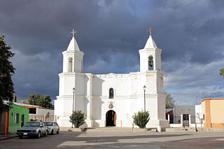
Magdalena de Kino is a city, part of the surrounding municipality of the same name, located in the Mexican state of Sonora covering approximately 560 square miles. According to the 2005 census, the city's population was 23,101, and the municipality's was 25,500. Magdalena de Kino is in the northern section of Sonora 50 miles from the Mexico-U.S. border. To the north the municipality abuts Nogales; to the south, the municipality of Santa Ana; to the east, Ímuris and Cucurpe; and to the west, the municipalities of Tubutama and Sáric. Its main sectors include San Ignacio, San Isidro, Tacicuri, and Sásabe. The city was named after the pioneer Roman Catholic missionary and explorer, Father Eusebio Francisco Kino, who worked in the area, as well as in the present-day US state of Arizona.
Aconchi is a small city in Aconchi Municipality that surrounds it, located in the center of the Mexican state of Sonora. The population of the municipality was 2,452 in 2005 in an area of 358.74 square kilometers. It became a municipality in 1932.
Bacerac is a town in Bacerac Municipality in the Mexican state of Sonora.

Bacoachi is a small town in Bacoachi Municipality in the north of the Mexican state of Sonora. The area of the municipality is 487 square miles (1,260.65 km2) and the population was 1,456 in 2005, with 924 inhabitants residing in the municipal seat. The elevation of the municipal seat is 4,429 feet above sea level.

Baviácora is a small town and the municipal seat of the surrounding municipality of the Mexican state of Sonora. The geographical coordinates are 29°42′N110°09′W.
Benjamín Hill is the municipal seat of Benjamín Hill Municipality in the Mexican state of Sonora.

Carbó is the municipal seat of Carbó Municipality of the state of Sonora, Mexico.
Cucurpe is the municipal seat of Cucurpe Municipality in the Mexican state of Sonora.
Fronteras is the seat of Fronteras Municipality in the northeastern part of the Mexican state of Sonora. Frontera translates as Border. The elevation is 1,120 meters and neighboring municipalities are Agua Prieta, Nacozari and Bacoachi. The area is 2839.62 km2, which represents 1.53% of the state total.
Granados is the municipal seat of Granados Municipality in the northeast of the Mexican state of Sonora. The municipal area is 361.27 km2, and the population was 1,228 according to the 2000 census. By 2005 the population had decreased to 938 due to emigration due to insufficient educational infrastructure and the lack of job opportunities.
Mazatán is a locality in Mazatán Municipality in the center of the Mexican state of Sonora.

Ónavas is a small town surrounded by Onavas Municipality in the southeast of the Mexican state of Sonora.

Quiriego is a small town and the county seat of the Municipality of Quiriego, located in the southeast of the Mexican state of Sonora.
Rayón is a small town surrounded by its municipal area in the center of the Mexican state of Sonora at a distance of 110 kilometers from the state capital Hermosillo.
El Cibuta is a town in the Mexican state of Sonora. The name is native and means “feather head dress” in the Tohono O’odham language the original inhabitants of the area. See the publication Trails to Tiburón The 1894 and 1895 Field Diaries of W J McGee
Granados is a municipality in the Mexican state of Sonora, located approximately 180 kilometres (110 mi) northeast of Hermosillo, the state capital. It is named after José Joaquín Granados y Gálvez, the second bishop of Sonora from 1788 to 1794.

Ímuris is a municipality in the state of Sonora in north-western Mexico.

Magdalena is a municipality in the state of Sonora in northwestern Mexico. In the 2020 Census, the municipality reported a total population of 33,049, up by 11.2% from the 2010 result.
Nogales is a municipality in the state of Sonora in northwestern Mexico, being the most densely populated municipality in Sonora. The name "Nogales" is the Spanish word for walnut trees.


