
Suvarnadurg is a fort that is located between Mumbai and Goa on a small island in the Arabian Sea, near Harnai in Konkan, along the West Coast of India, in the Indian state of Maharashtra.

Chiplun ( [t͡ʃipɭuːɳ]) is a city in Ratnagiri district in the state of Maharashtra, India. It is one of the financial and commercial hubs of Ratnagiri district, and the headquarters of Chiplun taluka. It is about 250 km south of Mumbai and 90 km North of Ratnagiri in the Konkan region of Maharashtra, on the Mumbai–Goa highway (NH-66). It has a long history and a strong cultural background. Recent decades have seen much industrial development in it and its and surrounding areas.

Kolaba Fort located at Alibag beach is an old fortified maritime base in Alibag, Konkan, India. It is situated in the sea at a distance of 1–2 km from the shores of Alibag, 35 km south of Mumbai, in the Konkan region of Maharashtra, India. It is a popular tourist destination and a protected monument.

Jaigad Fort(Marathi: जयगड किल्ला, Jayagaḍa killā) is a coastal fortification that is located at the tip of a peninsula in Jaigad, Ratnagiri District at a distance of 14 km from the temple town of Ganpatipule, in the state of Maharashtra, India. Nestled on a cliff, it overlooks a bay formed where the Shastri river enters the Arabian Sea. It has a commanding view of the bay, the nearby power plant and the open sea. A jetty port Angrey, and a lighthouse is located nearby. Although in ruins, most of the fort's outer wall and ramparts still stand. A deep moat surrounds the fort side not facing the cliff edge. In the middle of the 13 acre fort lies the palace of Kanhoji Angre, a Ganpati temple and wells to store water. It is a protected monument.

Torna Fort, also known as Prachandagad, is a large fort located in Pune district, in the Indian state of Maharashtra. It is historically significant because it was the first fort captured by Shivaji I in 1646, at the age of 16. The hill has an elevation of 1,403 metres (4,603 ft) above sea level, making it the highest hill-fort in the district. The name derives from Prachanda and gad.

Panhala fort, is located in Panhala, 20 kilometres northwest of Kolhapur in Maharashtra, India. It is strategically located looking over a pass in the Sahyadri mountain range which was a major trade route from Bijapur in the interior of Maharashtra to the coastal areas. Due to its strategic location, it was the centre of several skirmishes in the Deccan involving the Marathas, the Mughals and the British the grand son's of chhatrapati shivaji maharaj East India Company, the most notable being the Battle of Pavan Khind. Here, the queen regent of Kolhapur, Tarabai Ranisaheb, spent her formative years. Several parts of the fort and the structures within are still intact. It is also called as the 'Fort of Snakes' as it is zigzagged in shape.
Mandangad Fort is about 2 km from Mandangad town in Ratnagiri District, Maharashtra. This fort is said to be constructed by King Bhoj. After the Mughals lost the Battle of Umberkhind, This fort was captured by Shivaji in the battle with Adil Shah. A 400-year-old cannon is the major feature of the fort. The fort constitutes a Ganapati Temple and a tank called Thorla Talav.

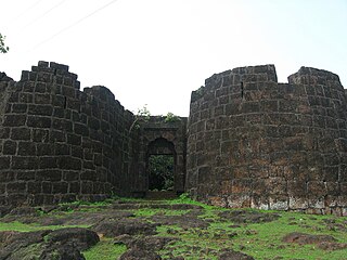
Vijaydurg, the oldest fort on the Sindhudurg coast, was constructed during the regime of Raja Bhoja II of the Shilahar dynasty and restructured by Shivaji.
Gowalkot is a small fort located on the southern bank of Vashishti River, about 10.0 km from Chiplun in Maharashtra, India. This fort is guarded by the river on three sides and a trench on the fourth side. Its population which includes Hindus, Muslims, and Buddhists. According to old natives of Gowalkot, the history of Gowalkot goes back to a King, who was Hindu and finally was converted in Muslim, his surname was "Chougle", and most of the land in Gowalkot is owned by the Chougle family. All other owner of land in Gowalkot must have either received the land as gift [or bought] from Chougle family must have lost in "kul kaida" a rule by the government.
Anjanwel is a small coastal town in Guhagar taluka, Ratnagiri district, in the Konkan region and administrative division of the Indian state of Maharashtra. It is located around 80 kilometres (50 mi) north of the district headquarters of Ratnagiri, 10 kilometres (6.2 mi) north of its taluka, and 200 kilometres (120 mi) south of Mumbai, the state capital. Marathi is the official language spoken by everyone in the village. The nearest villages are Veldur, which is home of an Enron plant, Dhopawe, Vanoshi T. Panchanadi, Navse, and Sakhari Trishul. The Gopalgad Fort, also known as Anjanvel Fort is a coastal fort, half of the fort is on a hill and the other half is directly adjacent to the Arabian Sea. Anjanwel has a tropical monsoon climate with 47% of humidity also due to its proximity to the sea.
Yashwantgad Fort is located in Redi, Maharashtra, near the Maharashtra-Goa border. It sits on a small hill north of Jaitapur Creek. The fort, now a tree-entangled ruin, overlooks the beaches of the southern Maharashtra coast.

Kenjalgad Fort in Wai, Maharashtra is a fort eleven miles (18 km) north-west of Wai. It is located on the Mandhardev spur of the Mahadev hill range. The fort is visible from quite a long distance as a stone scarp 30–40 feet high rising as a cap on the irregular hill. The fort is rhomboid in shape with 388m long axis and 175m short axis.
Bankot Fort / Himmatgad Fort/ Fort Victoria is a fort located 47 km from Dapoli, in Ratnagiri district, of Maharashtra. This fort is an important fort in Ratnagiri district. The Fort is located on a prominent and commanding point for guarding the trade route along the Savitri River, which runs till, Mahad which was a busy route in medieval times. It is a fort located on a hill near the sea.
Purnagad Fort is a fort located 25 km from Ratnagiri, in Ratnagiri district, of Maharashtra. This fort is very small but an important fort in Ratnagiri district for Kanhoji Angre's Navy that evolved as the modern Indian Navy. The Fort is spread over 22 acres and located on a northern hill on Muchkundi River.

Ratnagiri Fort, also called Ratnadurg Fort or Bhagawati Fort, is a fort located 2 km from Ratnagiri, in Ratnagiri district, of Maharashtra. This fort is an important fort in Ratnagiri district. The fort is a main tourist attraction due to the Bhagawati Temple inside the fort.
Bharatgad Fort is a fort located 18 km from Malvan, in Sindhudurg district, of Maharashtra. This fort is located on the southern bank of Gad river or Kalaval creek. The fort is spread over an area of 4-5 acres and covered with mango orchard.
Goa Fort is a fort located 15 km from Dapoli, in Ratnagiri district, of Maharashtra. This fort is one of the three forts built to guard the Suvarnadurg fort, the other two forts are Kanakdurg and Fattedurg. The fort is a main tourist attraction in the Harne village. A favourite evening haunt for the thrill likers to chill out, Chapora Fort in North Goa is yet another popular destination for the patrons.
Fattegad is a fort located 15 km from Dapoli, in the Ratnagiri district of Maharashtra. It is one of three forts built to guard the Suvarnadurg fort; the other two are Goa fort and Kanakdurg.
Sarjekot Fort is an old military fortification in India. it is situated very close to the Malvan. It is located in the Arabian Sea close to the Malvan town in Sindhudurg District of Maharashtra state.
Vijaygad Fort / is a fort located 60 km from Chiplun, in Ratnagiri district, of Maharashtra. This fort is located north of the Jaigad Fort on the northern bank of shastri river creek.


