
Southern California is a geographic and cultural region that generally comprises the southernmost counties of California, and is the second most populous urban agglomeration in the United States. The region contains ten counties: Imperial, Kern, Los Angeles, Orange, Riverside, San Bernardino, San Diego, Santa Barbara, San Luis Obispo and Ventura counties. The Colorado Desert and the Colorado River are located on southern California's eastern border with Arizona, and the Mojave Desert is located north on California's Nevada border. Southern California's southern border is part of the Mexico–United States border.

Kern County is a county in the U.S. state of California. As of the 2010 census, the population was 839,631. Its county seat is Bakersfield.

Palmdale is a city in northern Los Angeles County in the U.S. state of California. The city lies in the Antelope Valley region of Southern California. The San Gabriel Mountains separate Palmdale from the city of Los Angeles to the south.

Tulare Lake, Laguna de Tache in Spanish, is a freshwater dry lake with residual wetlands and marshes in the southern San Joaquin Valley, California, United States. After Lake Cahuilla disappeared in the 17th century, Tulare Lake was the largest freshwater lake west of the Mississippi River and the second-largest freshwater lake entirely in the United States, based upon surface area. A remnant of Pleistocene-era Lake Corcoran, Tulare Lake dried up after its tributary rivers were diverted for agricultural irrigation and municipal water uses.

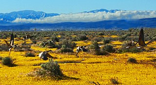
Antelope Valley California Poppy Reserve is a state-protected reserve of California, USA, harboring the most consistent blooms of California poppies, the state flower. The reserve is located in the rural west side of Antelope Valley in northern Los Angeles County, 15 miles (24 km) west of Lancaster. To the north is Kern County. The reserve is at an elevation ranging from 2,600 to 3,000 feet above sea level, in the Mojave Desert climate zone. The reserve is administered by the California Department of Parks and Recreation. Other wildflowers within the reserve include the owl's clover, lupine, goldfields, cream cups and coreopsis.
Antelope Valley is located in northern Los Angeles County, California, and the southeast portion of Kern County, California, and constitutes the western tip of the Mojave Desert. It is situated between the Tehachapi, Sierra Pelona, and the San Gabriel Mountains. The valley was named for the pronghorns that roamed there until they were all but eliminated in the 1880s, mostly by hunting, or resettled in other areas. The principal cities in the Antelope Valley are Palmdale and Lancaster.
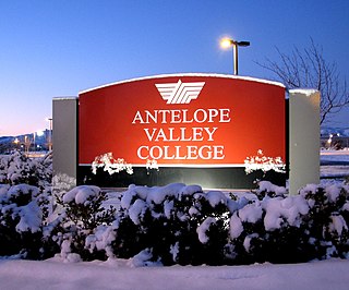
Antelope Valley College (AVC) is a public community college in Lancaster, California. It is part of the California Community College system. It is operated by the Antelope Valley Community College District, with a primary service area of 1,945 square miles (5,040 km2) covering portions of Los Angeles and Kern counties. Instruction is offered at several sites, including Palmdale and Lancaster, and through online and instructional television courses.

The Antelope Valley Line is a commuter rail line that serves the Northern Los Angeles County area as part of the Metrolink system. The line is rural in character because it travels through the sparsely populated Soledad Canyon between Santa Clarita and Palmdale, serving the small community of Acton along the way. Other portions of its route parallel the former US Route 6, now San Fernando Road and Sierra Highway.

Antelope Valley High School is located in Lancaster, California, and is part of the Antelope Valley Union High School District, in northernmost Los Angeles County, California. It was founded in 1912, and had its first graduating class in 1912. It is located near the western edge of the Mojave Desert. At the time of its founding, classes were held at the Women's Independence Hall on Cedar Ave. and Lancaster Blvd. until a permanent building could be built. In July 1914, construction began on a concrete building, Central Hall, and was completed in mid-1915. However, a strike over unpaid wages prevented students from entering the new building at the beginning of the 1915 school year. It was settled, and students began their classes in the new building in October 1915. The school was a residential boarding school serving students from farms and ranches from north Los Angeles and south Kern counties. At present, the school primarily serves the population of Lancaster, California.

Area code 661 is a California telephone area code that covers the majority of California's Kern County, as well as part of Los Angeles County, Santa Barbara County, and Tulare County. It was split from area code 805 on February 13, 1999.
The Bakersfield Californian is a daily newspaper serving Bakersfield, California and surrounding Kern County in the state's San Joaquin Valley.

Elizabeth Lake is a natural lake that lies directly on the San Andreas Fault in the northern Sierra Pelona Mountains, in northwestern Los Angeles County, southern California.

High Desert is an informal designation, with non-discreet boundaries, applied to areas of the Mojave Desert in Southern California that are generally between 2,000 feet (610 m) and 4,000 feet (1,200 m) in elevation, and located just north of the San Bernardino and Little San Bernardino Mountains.

Blackwells Corner is an unincorporated community in the Antelope Valley of Kern County, California. It is located 50 miles (80 km) west-northwest of Bakersfield, at an elevation of 650 feet. Blackwells Corner is at the intersection of California State Route 46 and California State Route 33, and was the last place James Dean was seen alive prior to his death in a car wreck.
Kecks Corner is an unincorporated community in Kern County, California. It is located in Antelope Valley 5.5 miles (8.9 km) south-southeast of Orchard Peak, at an elevation of 850 feet (259.08 m).
Indian Springs is a former settlement in Kern County, California.
Antelope Valley may refer to:

Hi Vista is an unincorporated community in northeastern Los Angeles County, California, United States. Hi Vista is sometimes confused with Lancaster because both communities use the same zip code of 93535.

The Old Tejon Pass is a mountain pass in the Tehachapi Mountains linking Southern and Central California.
George Philip Hummel was an American business manager and investor. Resident engineer for Kern County, California, he has been cited as a county pioneer and one of the legends of the Antelope Valley.

