Groveland Township is located in LaSalle County, Illinois. It is at the very southern end of LaSalle County. As of the 2010 census, its population was 628 and it contained 299 housing units. Groveland Township was formed from Eagle Township sometime prior to September, 1856.

Anchor Township is located in McLean County, Illinois. As of the 2010 census, its population was 286 and it contained 139 housing units. Anchor Township formed from Cropsey Township in 1877. The township's name most likely is derived from the hymn "My Soul Is Anchored in the Cross".

Arrowsmith Township is located in McLean County, Illinois. As of the 2010 census, its population was 502 and it contained 203 housing units. Arrowsmith Township is named for Ezekiel Arrowsmith (1811–1894), the first supervisor of the township. The township was originally called "Pleasant", but since there was already a Pleasant Township in Illinois, the name was changed in honor of the first superintendent. Arrowsmith Township changed its name from Pleasant Township on May 17, 1858.

Bloomington Township is located in McLean County, Illinois. As of the 2010 census, its population was 2,851 and it contained 1,127 housing units. it is adjacent to the city of Bloomington.

Blue Mound Township is located in McLean County, Illinois. As of the 2010 census, its population was 441 and it contained 202 housing units.

Chenoa Township is located in McLean County, Illinois. As of the 2010 census, its population was 2,074 and it contained 928 housing units.

Cropsey Township is located in McLean County, Illinois. As of the 2010 census, its population was 222 and it contained 90 housing units. It was named after Col. A. J. Cropsey, the owner of a large farm in the area. In 1860 there were 25 families living in the township; by the 2000 census the total population was reported at 256.
Dawson Township is located in McLean County, Illinois. As of the 2010 census, its population was 590 and it contained 253 housing units.

Downs Township is located in McLean County, Illinois. At the 2010 census, its population was 1,266 and it contained 483 housing units. Downs Township was originally named Savanna Township, but it was changed on May 17, 1858.

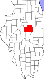
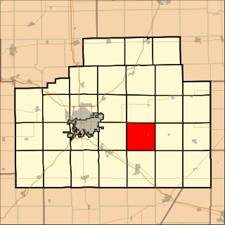
Empire Township is located in McLean County, Illinois. As of the 2010 census, its population was 4,093 and it contained 1,719 housing units. Empire Township changed its name from Le Roy Township on May 17, 1858.
Belle Prairie Township is located in Livingston County, Illinois in the United States. As of the 2010 census, its population was 135 and it contained 55 housing units.

Broughton Township is located in Livingston County, Illinois. As of the 2010 census, its population was 313 and it contained 139 housing units. Broughton Township changed its name from Broughtonville Township on October 3, 1860.

Charlotte Township is located in Livingston County, Illinois. As of the 2010 census, its population was 136 and it contained 67 housing units. Charlotte Township formed from Saunemin Township sometime in 1865.

Chatsworth Township is located in Livingston County, Illinois. As of the 2010 census, its population was 1,366 and it contained 639 housing units.

Indian Grove Township is located in Livingston County, Illinois. As of the 2010 census, its population was 4,297 and it contained 1,814 housing units. Indian Grove Township changed its name from Worth Township on May 11, 1858.

Saunemin Township is located in Livingston County, Illinois, United States. As of the 2010 census, its population was 666 and it contained 281 housing units. It is named after, and contains, Saunemin, Illinois.

Douglas Township is one of twenty-six townships in Iroquois County, Illinois, USA. As of the 2010 census, its population was 2,104 and it contained 923 housing units. Douglas Township was formed from a portion of Onarga Township in May 1858.

Onarga Township is one of twenty-six townships in Iroquois County, Illinois, United States. As of the 2010 census, its population was 1,683 and it contained 647 housing units.

Ridgeland Township is one of twenty-six townships in Iroquois County, Illinois, USA. As of the 2010 census, its population was 369 and it contained 173 housing units. Ridgeland Township was formed from Onarga Township on January 29, 1879; the original name was Ridge Township, but the name was changed to Ridgeland Township on an unknown date.

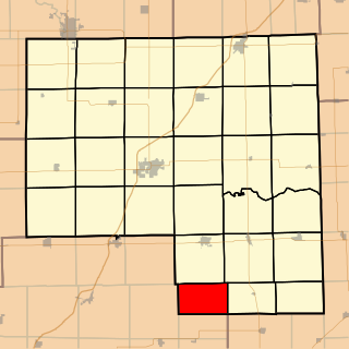
Fox Township is one of eleven townships in Jasper County, Illinois, USA. As of the 2010 census, its population was 512 and it contained 205 housing units.