Hounslow is a large suburban district of West London, England, 10+3⁄4 miles west-southwest of Charing Cross. It is the administrative centre of the London Borough of Hounslow, and is identified in the London Plan as one of the 12 metropolitan centres in Greater London.

Chiswick is a district in the London Borough of Hounslow, West London, England. It contains Hogarth's House, the former residence of the 18th-century English artist William Hogarth; Chiswick House, a neo-Palladian villa regarded as one of the finest in England; and Fuller's Brewery, London's largest and oldest brewery. In a meander of the River Thames used for competitive and recreational rowing, with several rowing clubs on the river bank, the finishing post for the Boat Race is just downstream of Chiswick Bridge.

The London Borough of Hounslow is a London borough in West London, England, forming part of Outer London. It was created in 1965 when three smaller borough councils amalgamated under the London Government Act 1963. It is governed by Hounslow London Borough Council.
Gunnersbury is an area of West London, England.

Isleworth is a town located within the London Borough of Hounslow in West London, England. It lies immediately east of the town of Hounslow and west of the River Thames and its tributary the River Crane. Isleworth's original area of settlement, alongside the Thames, is known as 'Old Isleworth'. The north-west corner of the town, bordering on Osterley to the north and Lampton to the west, is known as 'Spring Grove'.

Fuller, Smith & Turner is a public limited company based in London, England. Its origins lie in John Fuller's Griffin Brewery, which dates from 1816. In 1845, John Fuller's son, John Bird Fuller, was joined by Henry Smith and John Turner to form the current company.

The A316, known in parts as the Great Chertsey Road, is a major road in England, which runs from the A315 Chiswick High Road, Turnham Green, Chiswick to join head-on the M3 motorway at Sunbury-on-Thames. Its initial London section Chiswick Lane heads south – following this it is a mostly straight dual carriageway aligned WSW.

Gunnersbury Park is a park between Acton, Brentford, Chiswick and Ealing, West London, England. Purchased for the nation from the Rothschild family, it was opened to the public by Neville Chamberlain, then Minister of Health, on 21 May 1926. The park is currently jointly managed by Hounslow and Ealing borough councils. A major restoration project funded by the Heritage Lottery Fund was completed in 2018. The park and garden is Grade II listed.
Strand-on-the-Green is one of Chiswick's four medieval villages, and a "particularly picturesque" riverside area in West London. It is a conservation area, with many "imposing" listed buildings beside the River Thames; a local landmark, the Kew Railway Bridge that crosses the River Thames and the Strand, is itself Grade II listed. Oliver's Island is just offshore.
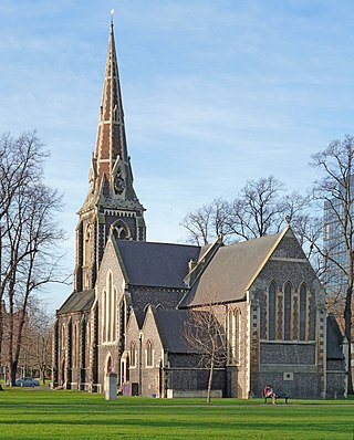
Turnham Green is a public park on Chiswick High Road, Chiswick, London, and the neighbourhood and conservation area around it; historically, it was one of the four medieval villages in the Chiswick area, the others being Old Chiswick, Little Sutton, and Strand-on-the-Green. Christ Church, a neo-Gothic building designed by George Gilbert Scott and built in 1843, stands on the eastern half of the green. A war memorial stands on the eastern corner. On the south side is the old Chiswick Town Hall.

Chiswick Eyot is a 3.266-acre (1.3 ha) narrow, uninhabited ait of the Thames. It is a tree- and reed-covered rise on the Tideway by Chiswick, in London, England and is overlooked by Chiswick Mall and by some of the Barnes riverside on the far bank.

Oliver's Island is a tree-covered 0.9-acre (0.36 ha) ait, in the River Thames in England. It is in the London Borough of Hounslow, on the Tideway, facing Kew and Strand-on-the-Green in the London Borough of Richmond upon Thames, and is owned by the Port of London Authority.

The George and Devonshire is a Grade II listed public house at Burlington Lane, Chiswick, London. It was built in the 18th century, but the architect is not known. The pub claims that it dates back to 1650.

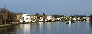
Chiswick Mall is a waterfront street on the north bank of the river Thames in the oldest part of Chiswick in West London, with a row of large houses from the Georgian and Victorian eras overlooking the street on the north side, and their gardens on the other side of the street beside the river and Chiswick Eyot.

The Grade I listed building Walpole House is the largest, finest, and most complicated of the grand houses on Chiswick Mall, a waterfront street in the oldest part of Chiswick. Both the front wrought-iron screen and gate, and the back boundary wall, are Grade II listed.

Old Chiswick is the area of the original village beside the river Thames for which the modern district of Chiswick is named. The village grew up around St Nicholas Church, founded c. 1181 and named for the patron saint of fishermen. The placename was first recorded c. 1000 as Ceswican. In the Middle Ages the villagers lived by fishing, boatbuilding, and handling river traffic. The surrounding area was rural until the late 19th century.

Little Sutton was one of the four constituent medieval villages of Chiswick, in what is now West London, and the site of a royal manor house, Sutton Manor, later Sutton Court. The great house was accompanied by a small hamlet without a church of its own.

The Duke of Sussex, Acton Green is a public house, opened in 1898, in the northern Chiswick district of Acton Green. It is prominently situated on a corner facing the common. The Grade II listed building is "elaborately decorated" to a design by the pub architects Shoebridge & Rising.
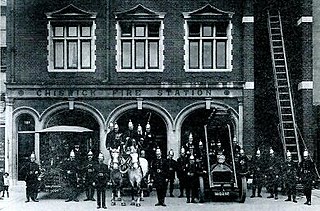
The Old Fire Station, Chiswick is an 1891 brick building with stone facings on Chiswick High Road. It served as a fire station until 1963, and has since been used as a restaurant.

Chiswick High Road is the principal shopping and dining street of Chiswick, a district in the west of London. It was part of the main Roman road running west out of London, and remained the main road until the 1950s when the A4 was built across Chiswick. By the 19th century the road through the village of Turnham Green had grand houses beside it. The road developed into a shopping centre when Chiswick became built up with new streets and housing to the north of Old Chiswick, late in the 19th century. There are several listed buildings including public houses, churches, and a former power station, built to supply electricity to the tram network.