
The Los Angeles County Metropolitan Transportation Authority (LACMTA), branded as Metro, is the county agency that plans, operates, and coordinates funding for most of the public transportation system in Los Angeles County, California, the most populated county in the United States.

The Los Angeles Metro Rail is an urban rail transit system serving Los Angeles County, California in the United States. It consists of six lines: four light rail lines and two rapid transit lines, serving a total of 101 stations. It connects with the Metro Busway bus rapid transit system, the Metrolink commuter rail system, as well as several Amtrak lines. Metro Rail is owned and operated by the Los Angeles County Metropolitan Transportation Authority (Metro).
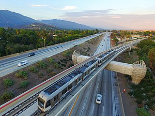
The A Line is a 48.5-mile (78.1 km) light rail line in Los Angeles County, California. The A Line runs east-west between Azusa and Pasadena, then north-south between Pasadena and Long Beach, via Downtown Los Angeles. The A Line is currently the longest light rail line in the world.

The E Line is a 22-mile (35 km) light rail line in Los Angeles County, California, running between Santa Monica and East Los Angeles. It is one of the six lines in the Los Angeles Metro Rail system and is operated by the Los Angeles County Metropolitan Transportation Authority (Metro).

Slauson station is an elevated light rail station on the A Line of the Los Angeles Metro Rail system. The station is located within the historic right-of-way of the Pacific Electric Railway and elevated over the intersection of Slauson Avenue, after which the station is named, in the unincorporated Los Angeles County community of Florence.

The West Santa Ana Branch is a rail right-of-way formerly used by the Pacific Electric's (PE) Santa Ana route in Los Angeles County and Orange County in Southern California. The Los Angeles County Metropolitan Transportation Authority (Metro) owns the segment of the right-of-way in Los Angeles County, and the Orange County Transportation Authority (OCTA) owns the segment in Orange County.
Culver City station is an elevated light rail station on the E Line of the Los Angeles Metro Rail system. The station is located on a dedicated right-of-way alongside Exposition Boulevard — between the intersection of Venice Boulevard and Robertson Boulevard on the west and the intersection of Washington Boulevard and National Boulevard on the east. The station is located in the city of Culver City, California, after which the station is named.

The Santa Ana Line was an interurban railway route connecting Los Angeles and Santa Ana in Orange County. It ran between 1905 and 1958 and was predominantly operated by the Pacific Electric Railway for its history.

The Long Beach Line was a major interurban railway operated by the Pacific Electric Railway between Los Angeles and Long Beach, California via Florence, Watts, and Compton. Service began in 1902 and lasted until 1961, the last line of the system to be replaced by buses.
The OC Streetcar is a modern streetcar line currently under construction in Orange County, California, running through the cities of Santa Ana and Garden Grove. The electric-powered streetcar will be operated by the Orange County Transportation Authority (OCTA), and will serve ten stops in each direction along its 4.15-mile (6.68 km) route. With the exception of a short loop in downtown Santa Ana, the line will be double-tracked for its entire length. Most of the route follows the original path of the Pacific Electric Railway "Red Cars" that served Santa Ana in the early 20th century, before being abandoned in 1950. Construction on the streetcar broke ground on November 30, 2018. As of October 2023, the line's expected revenue service date has been pushed to August 2025, per OCTA staff, despite initial plans for a 2021 start.
The Southeast Gateway Line, formerly the West Santa Ana Branch Transit Corridor, is a planned light rail line, mostly following the Pacific Electric's historic West Santa Ana Branch, connecting Downtown Los Angeles to the city of Artesia, along with other cities in southeastern Los Angeles County.

The Eastside Transit Corridor is a light rail line extension that currently connects Downtown Los Angeles with East Los Angeles. However, the extension is planned to extend further southeast to connect with the Gateway Cities, continuing from a relocated Atlantic station southeast to a new Lambert station in Whittier.
Bellflower station is a planned light rail station in the Los Angeles Metro Rail system. It is part of the Southeast Gateway Line project. The segment of the corridor is expected to begin operations in 2035.
Paramount/Rosecrans station is a planned elevated light rail station in the Los Angeles Metro Rail system. It is located at the intersection of Paramount Boulevard and Rosecrans Avenue in Paramount, California and is part of the Southeast Gateway Line project. The segment of the corridor is expected to begin operations in 2035.
Pioneer station is a planned light rail station in the Los Angeles Metro Rail system. It will be the southern terminus of the Southeast Gateway Line project, located in Artesia at Pioneer Boulevard. The segment of the corridor is expected to begin operations in 2035. The route may later on be further expanded along the West Santa Ana right-of-way, but Metro has not yet announced any plans to do so.
Pacific/Randolph station is a planned light rail station in Huntington Park, California. It will operate as part of the Los Angeles Metro Rail system. It is part of the Southeast Gateway Line project. The segment of the corridor is expected to begin operations in 2035.
Florence/Salt Lake station is a planned light rail station in the Los Angeles Metro Rail system. It is located at the intersection of Florence Avenue and Salt Lake Avenue in Huntington Park, California and is part of the Southeast Gateway Line project. The segment of the corridor is expected to begin operations in 2035.
Gardendale station is a planned light rail station in the Los Angeles Metro Rail system. It is located near the intersection of Garfield Avenue and Gardendale Street in Downey, California and is part of the Southeast Gateway Line project. The segment of the corridor is expected to begin operations in 2035.
I-105/C Line station is a proposed infill light rail transfer station in the Los Angeles Metro Rail system. It is located near Century Boulevard above Interstate 105 in Paramount, California and is part of the Southeast Gateway Line project. A new infill station for a C Line transfer. The segment of the corridor is expected to begin operations in 2035.
