
Norwalk is a city in Los Angeles County, California, United States. The population was 102,773 at the 2020 census.

The Pacific Electric Railway Company, nicknamed the Red Cars, was a privately owned mass transit system in Southern California consisting of electrically powered streetcars, interurban cars, and buses and was the largest electric railway system in the world in the 1920s. Organized around the city centers of Los Angeles and San Bernardino, it connected cities in Los Angeles County, Orange County, San Bernardino County and Riverside County.

The Los Angeles County Metropolitan Transportation Authority (LACMTA), branded as Metro, is the county agency that plans, operates, and coordinates funding for most of the public transportation system in Los Angeles County, California, the most populated county in the United States.
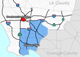
The Gateway Cities Region, or Southeast Los Angeles County, is an urbanized region located in southeastern Los Angeles County, California, between the City of Los Angeles proper, Orange County, and the Pacific Ocean. The cluster of cities has been termed "Gateway Cities" in that they serve as a "gateway" between the LA and Orange counties, with the city of Cerritos equidistant from Downtown L.A., Long Beach, and Santa Ana in Orange County. As such, the area is central to the Los Angeles-Long Beach-Anaheim, CA Metropolitan Statistical Area (MSA), and has a population of approximately 2,000,000 residents.
The A Line is a 48.5-mile (78.1 km) light rail line in Los Angeles County, California. The A Line runs east-west between Azusa and Pasadena, then north-south between Pasadena and Long Beach, via Downtown Los Angeles. The A Line is currently the longest light rail line in the world.

Vermont Avenue is one of the longest running north–south streets in City of Los Angeles and Los Angeles County, California. With a length of 23.3 miles (37.5 km), is the third longest of the north–south thoroughfares in the region. For most of its length between its southern end in San Pedro and south of Downtown Los Angeles, it runs parallel to the west of the Harbor Freeway (I-110).

Slauson station is an elevated light rail station on the A Line of the Los Angeles Metro Rail system. The station is located within the historic right-of-way of the Pacific Electric Railway and elevated over the intersection of Slauson Avenue, after which the station is named, in the unincorporated Los Angeles County community of Florence.

Norwalk Transit is a municipal transit company providing fixed-route and paratransit bus transit services in Norwalk, California, United States, and also operates in portions of Artesia, Bellflower, Cerritos, La Habra, La Mirada, Santa Fe Springs and Whittier in southeast Los Angeles County and northwestern Orange County. In 2022, the system had a ridership of 851,800, or about 4,000 per weekday as of the third quarter of 2023.
Artesia Boulevard is a west-east thoroughfare in Los Angeles County and Orange County.

Greater Los Angeles has a complex multimodal transportation infrastructure, which serves as a regional, national and international hub for passenger and freight traffic. The transportation system of Greater Los Angeles includes the United States' largest port complex, seven commuter rail lines, Amtrak service, a subway system within the city of Los Angeles, and numerous highways. Los Angeles is integrated into the Interstate Highway System by Interstate 5, Interstate 10, and Interstate 15, along with numerous auxiliary highways and state routes. Bus service is also included locally within the area by numerous local government agencies. Subways and light commuter rail lines are present within Los Angeles proper, allowing mass transportation within the city. Commuter railroads are run by Metrolink. Amtrak has numerous railroad lines that connect Los Angeles to the rest of the country.

The West Santa Ana Branch is a rail right-of-way formerly used by the Pacific Electric's (PE) Santa Ana route in Los Angeles County and Orange County in Southern California. The Los Angeles County Metropolitan Transportation Authority (Metro) owns the segment of the right-of-way in Los Angeles County, and the Orange County Transportation Authority (OCTA) owns the segment in Orange County.

The Santa Ana Line was an interurban railway route connecting Los Angeles and Santa Ana in Orange County. It ran between 1905 and 1958 and was predominantly operated by the Pacific Electric Railway for its history.

The Long Beach Line was a major interurban railway operated by the Pacific Electric Railway between Los Angeles and Long Beach, California via Florence, Watts, and Compton. Service began in 1902 and lasted until 1961, the last line of the system to be replaced by buses.
The OC Streetcar is a modern streetcar line currently under construction in Orange County, California, running through the cities of Santa Ana and Garden Grove. The electric-powered streetcar will be operated by the Orange County Transportation Authority (OCTA), and will serve ten stops in each direction along its 4.15-mile (6.68 km) route. With the exception of a short loop in downtown Santa Ana, the line will be double-tracked for its entire length. Most of the route follows the original path of the Pacific Electric Railway "Red Cars" that served Santa Ana in the early 20th century, before being abandoned in 1950. Construction on the streetcar broke ground on November 30, 2018. As of October 2023, the line's expected revenue service date has been pushed to August 2025, per OCTA staff, despite initial plans for a 2021 start.
The Southeast Gateway Line, formerly the West Santa Ana Branch Transit Corridor, is a planned light rail line, mostly following the Pacific Electric's historic West Santa Ana Branch, connecting Downtown Los Angeles to the city of Artesia, along with other cities in southeastern Los Angeles County.
Bellflower station is a planned light rail station in the Los Angeles Metro Rail system. It is part of the Southeast Gateway Line project. The segment of the corridor is expected to begin operations in 2035.
Paramount/Rosecrans station is a planned elevated light rail station in the Los Angeles Metro Rail system. It is located at the intersection of Paramount Boulevard and Rosecrans Avenue in Paramount, California and is part of the Southeast Gateway Line project. The segment of the corridor is expected to begin operations in 2035.
Pacific/Randolph station is a planned light rail station in Huntington Park, California. It will operate as part of the Los Angeles Metro Rail system. It is part of the Southeast Gateway Line project. The segment of the corridor is expected to begin operations in 2035.
Firestone station is a planned elevated light rail station in the Los Angeles Metro Rail system. It is located near the intersection of Firestone Boulevard and Atlantic Avenue in South Gate, California and is part of the Southeast Gateway Line project. The segment of the corridor is expected to begin operations in 2035.
I-105/C Line station is a proposed infill light rail transfer station in the Los Angeles Metro Rail system. It is located near Century Boulevard above Interstate 105 in Paramount, California and is part of the Southeast Gateway Line project. A new infill station for a C Line transfer. The segment of the corridor is expected to begin operations in 2035.
