
Srinagar is the largest city and the summer capital of Jammu and Kashmir, India. It lies in the Kashmir Valley on the banks of the Jhelum River, a tributary of the Indus, and Dal and Anchar lakes. The city is known for its natural environment, gardens, waterfronts and houseboats. It is known for traditional Kashmiri handicrafts like the Kashmir shawl, and also dried fruits. It is the 32nd-most populous city in India, the northernmost city in India to have over one million people, and the second-largest metropolitan area in the Himalayas.

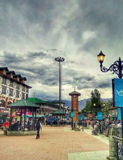
Bijbehara (Urdu pronunciation: [bɪd͡ʒbɪhaːɽaː], known as Vejibror in Kashmiri, is a town and a notified area committee in Anantnag district of the Indian administered union territory of Jammu and Kashmir. It is located on NH 44, and jehlum bank. Bijbehara town is also known as "Town of Chinars" because of a number of Chinars there especially two Chinar gardens. Bijbehara is the home to oldest chinar tree in the region. The town is situated about 45 km from the summer capital of union territory of Jammu and Kashmir, Srinagar.

Pampore, known as Pampar or Panpar in Kashmiri, is a historical town, of Jammu and Kashmir, India, situated on the eastern side of river Jehlum on Jammu-Srinagar National Highway in the Indian union territory of Jammu and Kashmir. It was known as Padmanpur in antiquity. It is famous worldwide for its saffron and known as the Saffron town of Kashmir. Pampore is one of the few places in the world where saffron, the world's most expensive spice, grows. The area is about 11 kilometres (6.8 mi) from Srinagar city centre Lal Chowk. Areas of Pampore typically have -bal as a suffix, such as the localities of Namlabal, Kadlabal, Drangbal, Frestabal, and Letrabal. Pampore has three lakes as well which have been entitled as wetlands. One of the lakes is known as Sarbal Lake. The Sarbal Lake is situated on the way from Tulbagh to Wuyan through saffron fields near Chatlam. On the basis of its location near Chatlam, it is also known as Chatlam Wetland.
Bemina is a region in Srinagar, the summer capital city of Jammu and Kashmir, India. It is in the heart of the summer capital of Jammu and Kashmir just about 4 km (2.5 mi) from Lal Chowk. It lies in the Batamaloo Assembly Constituency, Batamaloo assembly segment of the Srinagar parliamentary constituency. Bemina is one of the biggest south Asian residency colonies.
Lal Chowk is a city square in Srinagar, Jammu and Kashmir, India.

Soura, known as Sovur in Kashmiri, is a notified area in Srinagar district, Jammu and Kashmir. It is located about 9 km north of Lal Chowk, Srinagar on Srinagar-Ladakh Highway in Jammu and Kashmir, India. Soura is noted for Sher-i-Kashmir Institute of Medical Sciences, a multi-specialty hospital. Besides serving as a hospital, it is the medical deemed university of Kashmir valley. Soura is located near Anchar Lake. The whole western side of the area is covered by Anchar Lake. It also hosts a famous Muslim Shrine known as Asar-e-Sharif Jinab Sahib Soura which holds more than 13 holy relics.

Bagh e Mehtab is located in Srinagar, Jammu and Kashmir, India, about 7 km away from city centre, Lal Chowk. The area is primarily a residential area with a government housing colony and many private colonies.
Lasjan is developing area situated in Srinagar (south) tehsil and 07.23 kilometres (4.49 mi) located in Srinagar district of Jammu and Kashmir, India. It is one of 6 cities in Srinagar (south) block along with mohallas like Nowgam and Bagh e Mehtab. Nearby cities include Lasjan Padshai Bagh, 06.10 kilometres (3.79 mi) and Jawahar nagar 05.11 kilometres (3.18 mi) from Lal Chowk Srinagar. It is an industrial area as there are many hot mix plants, stone crusher and brick kiln.

The Government Medical College, Srinagar is a government medical college and hospital at Srinagar, Jammu and Kashmir. It was established in 1959. It is the oldest medical college in Kashmir. The college and hospital are affiliated with the University of Kashmir and recognized by the Medical Council of India. The college is located in the Karan Nagar area of Srinagar, about 1.5 km (0.93 mi) from Lal Chowk. The girls' hostel is located within the campus but the boys' hostel is one km (0.62 mi) away. It has well-equipped labs. The selection to the college is done on the basis of merit through National Eligibility and Entrance Test.
Buchpora is a town on the outskirts of Srinagar, Jammu and Kashmir, India. It is situated on Srinagar-Leh Highway on the eastern side of Anchar Lake. The postal code of the area is 190020. The area is about 12.1 km (7.5 mi) north from Lal Chowk. Most of the current inhabitants of the area are migrants from Downtown Srinagar. During the project of widening the roads in Downtown, numerous houses obstructing the widening of roads were shattered down. The homeless people were given plots of land by state government in neighbouring areas including Buchpora and Soura. Thus government housing colonies were constructed in these areas. there are many areas adjacent to this area, Illahi bagh, Rang pora, Umerhaira, are some of them. The area was an agriculture land but has been converted into a residential area.

Hazratbal is the notified area situated in Srinagar district in Jammu and Kashmir, India. It is about 10 km (6.2 mi) from Srinagar city center. The early settlements in the area occurred on the banks of Dal Lake and majority of population of area are Hangis (fishermen). The area became famous after the construction of Hazratbal Shrine where hundreds of thousands of people visit every year because many relics related to the Islamic prophet Muhammad are believed to be there.

In September 2014, the Kashmir region suffered disastrous floods across many of its districts caused by torrential rainfall. The Indian administered state of Jammu and Kashmir, as well as the Pakistani administered territories of Azad Kashmir, Gilgit-Baltistan and the province of Punjab were affected by these floods. By 24 September 2014, nearly 277 people in India and about 280 people in Pakistan had died due to the floods.

In the wake of heavy monsoon rain and flash floods in Jammu and Kashmir, the Indian Armed Forces were deployed in increasing numbers starting 2 September 2014 to conduct search, rescue, relief, relocation, humanitarian assistance and rehabilitation missions in Jammu and Kashmir. By 18 September, over 298,514 people were rescued from the various parts of Jammu and Kashmir by the Armed forces. The Jammu and Kashmir floods, the worst in a century according to Omar Abdullah, the Chief Minister of Jammu and Kashmir, paralyzed the state government. Omar Abdullah, responding to public criticism, told the media "I had no government" in the first few days following the floods, as "My secretariat, the police headquarters, the control room, fire services, hospitals, all the infrastructure was underwater." Adding "I had no cell phone and no connectivity. I am now starting to track down ministers and officers." The Jammu and Kashmir floods of 2014 have been blamed on heavy rainfall, about 8 inches (200mm) on 4 September alone, on climate change, unplanned and uncontrolled development, encroachment of river banks, lakes, ponds, and massive loss of wet lands, absence of local government flood forecasting system, and poor governance. The Armed Forces humanitarian assistance mission in response to the floods was named Mission Sahayata (assistances). Northern Command's humanitarian assistance to Civil authorities was named 'Operation Megh Rahat'. The Indian Army, Air Force, and the Navy, committed large resources to the assistance mission including over 30,000 troops, 15 engineer task forces, 84 Indian Air Force and Army Aviation Corps fixed wing transport aircraft and helicopters, naval commandos and rescue specialists, and Base Hospital, four field hospitals, over 106 medical detachments. "Operation Megh Rahat", ended on 19 September 2014, but "Operation Sadbhavna", the relief and medical assistance support, according to government press release, will continue in "close synergy with the civil administration and the police".
Rajbagh is the notified area in the municipal committee of Srinagar, in the Indian union territory of Jammu and Kashmir. It comes under the Amira Kadal Constituency. Rajbagh is a posh locality in the civil line area of Srinagar. The postal code of Rajbagh is 190008. Rajbagh is considered one of the many best residential places in Srinagar. There are many hotels, restaurants and schools in this locality. Rajbagh area was heavily damaged by the 2014 Kashmir floods, it was one of the worst affected areas due to flood.

Lal Bazar is a locality in the municipal committee of Srinagar in the Indian administered union territory of Jammu and Kashmir. It comes under the Zadibal constituency of the Srinagar Legislative Assembly. Lal Bazar is a well known posh area in the upper downtown area of Srinagar. The Pincode of Lal Bazar is 190011 & 190023. Considered amongst the best residential areas in Srinagar the area has many amenities such as major banks and schools along with University of Kashmir and NIT Srinagar close by, roughly 2 kms from Lal Bazar.
Downtown, popularly known as Shahar-e-Khaas, is the largest and the most densely populated area of the city of Srinagar in the Jammu and Kashmir. The area is mostly located on the banks of Jhelum river about five km (3.1 mi) from city center. The area is considered as the core point in the city as the first inhabitants of the Srinagar lived there. In general, the whole area to the north of city centre Lal Chowk is considered a part of downtown although some areas hold high significance. The Jamia Masjid, Srinagar and many other shrines are located here, which makes it the central spiritual, religious, political and moral center of whole Kashmir.
Karan Nagar is the notified area and the town in the city of Srinagar in the Indian administered union territory of Jammu and Kashmir. A portion of Karan Nagar in the name of Deewan Bagh was the first declared civil colony in 1942 by the former princely state government of Jammu and Kashmir. It is a posh locality of Srinagar city. The famous SMHS hospital and Government Medical College is located here. It is located about 2 km (1.2 mi) from the commercial center of Kashmir, Lal Chowk.

The Lal Mandi Footbridge is a suspension-type pedestrian bridge located in the city of Srinagar in the Indian union territory of Jammu and Kashmir. It connects Wazir Bagh areas of the city to the city centre Lal Chowk.
Sonwar Bagh, sometimes referred to as Sonwar, is a residential area in Badami Bagh Cantonment on the outskirts of Srinagar city, in Srinagar district, Jammu and Kashmir, India. It is gradually becoming more commercial, as many schools, hotels and restaurants have been established there.
Indira Nagar is a residential area in the city of Srinagar in the Indian union territory of Jammu and Kashmir. It used to be a lake before but now only few hundred meters of the lake is left.


