Mareth Line

Last updated

Mareth Line
Part of French defence of Tunisia
Tunisia
MarethMap1943 en.png
Mareth Line in 1943
Coordinates 33°38′00″N10°18′00″E / 33.63333°N 10.30000°E / 33.63333; 10.30000
Height2,200 ft (670 m)
Length25 mi (40 km)
Site information
OwnerFrench colonial administration of Tunisia
OperatorFrench army (1939–1940)
Controlled by German–Italian Panzer Army (Deutsch-Italienische Panzerarmee/Armata Corazzata Italo-Tedesca) [1943]
ConditionDerelict
Site history
Built1936 (1936)
Built byFrench colonial administration of Tunisia and French Army
In useMarch 1943 (March 1943)
Materialsreinforced concrete
FateAbandoned after 1943
Battles/warsBattle of the Mareth Line
Garrison information
Past
commanders
Giovanni Messe
Erwin Rommel
Garrison1943, east to west: 136th Infantry Division Giovani Fascisti, 101st Motorised Division Trieste, 90th Light Division, 80th Infantry Division La Spezia, 16th Motorised Division Pistoia, 164th Light Afrika Division 15th Panzer Division (32 operational tanks)
Reserve: 21st Panzer Division, 10th Panzer Division (110 operational tanks); Djebel Tebaga to Djebel Melab: Raggruppamento Sahariano

The Mareth Line was a system of fortifications built by France in southern Tunisia in the late 1930s. The line was intended to protect Tunisia against an Italian invasion from its colony in Libya. The line occupied a point where the routes into Tunisia from the south converged, leading toward Mareth, with the Mediterranean Sea to the east and mountains and a sand sea to the west.

Contents

The line ran along the north side of Wadi Zigzaou for about 50 km (31 mi) south-westwards from the Gulf of Gabès to Cheguimi and the Djebel (mountain) Matmata on the Dahar plateau between the Grand Erg Oriental (Great Eastern Sand Sea) and the Matmata hills. The Tebaga Gap, between the Mareth line and the Great Eastern Sand Sea, a potential route by which an invader could outflank the Mareth line, was not surveyed until 1938.

After the French Armistice of 22 June 1940, the Mareth Line was demilitarised under the supervision of an Italo-German commission. Tunisia was occupied by Axis forces after Operation Torch in 1942 and the line was refurbished and extended by Axis engineers into a defensive position by building more defences between the line and Wadi Zeuss 3.5 mi (5.6 km) to the south but French-built anti-tank gun positions were too small for Axis anti-tank guns which had to be sited elsewhere.

The Battle of Medenine (6 March 1943) against the Eighth Army was a costly failure. At the Battle of the Mareth Line (16–31 March 1943) the Eighth Army was contained within the Mareth Line defences. An outflanking move west and north of the Mareth Line was followed by Operation Supercharge II which broke through the Axis defences of the Tebaga Gap and led them to retreat from the Mareth Line to Wadi Akarit. The Mareth Line is derelict and is commemorated at the Mareth Museum.

Background

French strategy

In the 1930s the defence of the French colonial empire (French Indochina, Pacific Islands, West Indies, African colonies and Syria–Lebanon) was left to the French Foreign Legion, colonial and "native" units, the Marine nationale (Navy) and the Armée de l'Air (Air Force). By the late 1930s, the Navy had only one aircraft carrier and the Armée de l'Air could spare only second-rate aircraft. Algeria, Morocco and Tunisia provided much of the manpower of the Armée coloniale and Tunisia, with the Italian colony of Libya to the east, was excepted from the priority given to the defence of metropolitan France. [1] French plans for defence of Tunisia assumed that Italy would launch an overwhelming assault that France could not easily oppose. Italy was expected to launch attacks on Egypt and Tunisia as soon as war was declared, with the Italian Navy securing supply and blocking any substantial Anglo-French relief. With a force of six divisions, a fortress division and a cavalry division to defend Tunisia, capable of only local operations with limited objectives. The French army considered the construction of a "Maginot Line in the desert" (ligne Maginot du désert). [2] [lower-alpha 1]

Geography

Central Tunisia is dominated by the Atlas Mountains, while the northern and southern portions are largely flat. The primary feature in the south is the Matmata Hills, a range running north-south roughly parallel to the Mediterranean coast. West of the hills, the land is the inhospitable Jebel Dahar and the Dehar region of desert beyond to the west, making the region between the hills and the coast the only easily traversed approach to northern Tunisia. [4] A smaller line of hills runs east–west along the northern edge of the Matmata range, further complicating this approach. At the far northern end of the Matmata Hills is the Tebaga Gap. From the Mediterranean the coastal plain rises gently to the Matmata Hills. The plain consists of gravels and sands, with salt flats between the sandy areas, which turn into bogs after light rain becoming impassable to wheeled vehicles. There are numerous wadis from the hills to the sea, including the bigger Wadi Zeuss and Wadi Zigzaou. Inland, the sources of the wadis are steep and rocky, widening near the coast, the beds having streams or muddy bottoms, with firmer areas traversable by vehicles. [5]

Plans

Topographic map of Tunisia Tunisia Topography.png
Topographic map of Tunisia

In January 1934 planning began on the new fortifications; Infantry officers selected the sites for strongpoints to dominate the ground in front with overlapping fields of fire. In 1936, the French government provided funds for construction after Italy formed the Rome–Berlin Axis with Germany, creating a greater threat to French security in North Africa. [6] [lower-alpha 2] The casemates designed for the line had much less concrete than comparable examples in France and had no fossé (gap) rather a stable door, in case the lower part was blocked by débris. In September 1936, during a meeting with General Joseph Georges, it was agreed that the fortification of the Mareth Line, Bizerte, Medenine, Ben Gardane and Foum Tataouine (Tataouine) must be completed. Medenine, Ben Gardane to the west and Tataouine to the east, were south of the proposed line, Tataouine being the place where the routes to Mareth passed through the bottleneck between the Matmata Mountains and the sea. [6]

The line was divided into eastern and western sectors with a main line of resistance and a reserve line about 0.93 mi (1.5 km) back. A secteur défensif (SD) was to be built on the rocky Dahar Plateau, which later became part of an SD across the Matmata Hills to Kebili on the edge of the Chott el Djerid. The chott and Chott El Fedjaj drained across Tunisia into Wadi Akarit, across Tunisia but Wadi Akarit was only sketchily fortified, the French concentrating on the Mareth Line 31 mi (50 km) south, to cover Gabes. [6] The gap between the Mareth Line and the Great Eastern Sand Sea, a potential route by which an invader could outflank the Mareth line, was not given consideration until 1938. General Georges Catroux and Colonel Gautsch surveyed the area and in their assessment predicted that three divisions could advance from the Libyan border to Ksar (fortified village) el Hallouf and Bir (well) Soltane in six days and then advance into the gaps either side of Djebel Melab and those between Djebel Tebaga and the Matmata Hills. [7]

Mareth Line

Mareth Line Panel Mareth Line Panel.jpg
Mareth Line Panel

The Mareth Line consisted of casemates surrounded by barbed wire and built for all-round defence in the main and reserve lines, the obstacles being doubled on the fronts and sides. The strongpoints in the main line included flanking machine-gun casemates and anti-tank gun positions; in the reserve line artillery emplacements provided covering fire in the gaps between the strongpoints in the main line. Some of the flanking casemates for machine-guns covering the gaps were connected by galleries; strongpoints on the plain and in hills had anti-tank positions. An anti-tank obstacle of vertical rails was built along the front of the line and the sides of Wadi Zigzaou were steepened. Eight artillery casemates, forty infantry casemates or blockhouses and fifteen command posts were built. The eastern sector had twelve strongpoints in the main line and eleven in the reserve line. The western sector had eleven strongpoints in the main line and seven in the reserve line. [6]

In the Matmata hills, Ksar el Hallouf covered an anti-tank ditch which continued the position beyond the main line which ended on the foothills. An infantry position was dug into the Matmata hills at Ksar-el-Hallouf and in the Dahar beyond, a strongpoint at Bir Soltane had two 75 mm turrets, removed from Char 2C tanks built in 1918. At Ben Gardane an advanced position was built consisting of a square redoubt inside an anti-tank ditch with casemates on the flanks and concrete infantry shelters. Small triangular strongpoints at the corners were surrounded by anti-tank rail obstacles that continued around the position. The Mareth line was equipped with obsolescent 75 mm and 47 mm naval guns for anti-tank defence and a few new 25 mm anti-tank guns and infantry small arms. The artillery casemates with 75 mm guns and most of the blockhouses and casemates had embrasures for automatic weapons. In 1938 work the Mareth line was so important that work on coast defences was stopped and in 1939 the line was occupied by colonial divisions and some locally raised units. After the outbreak of the war, a line of advanced positions (avant-postes) was built on high ground at Aram 6.2 mi (10 km) south of the main line. [6]

Second World War

Demilitarisation 1940, Axis occupation 1943

The Second World War began in 1939 but the Mareth Line was inactive from 1939 to 1940, as Italy remained neutral until a few days before the Armistice of 22 June 1940, after which, the line was demilitarised by an Italo-German commission. In November 1942, the British Eighth Army (General Bernard Montgomery) defeated Panzerarmee Afrika at the Second Battle of El Alamein and the British First Army landed in French North Africa in Operation Torch. Axis forces occupied Tunisia in the Tunisia Campaign and from November 1942 to March 1943, the Panzerarmee conducted a fighting retreat through Egypt and Libya, pursued by the Eighth Army. In March the Eighth Army reached the Libya–Tunisia border and paused at Medenine to prepare to attack the Mareth Line. Axis engineers built an outpost zone from Wadi Zeuss 3.5 mi (5.6 km) back to the Mareth Line. Field fortifications were constructed at Sidi el Guelaa, south of Aram on the main road from Medinine to Mareth, around Aram and at Bahira. The Mareth Line was refurbished for occupation by the Panzerarmee and by March 1943, more than 62 miles (100 km) of barbed wire, 100,000 anti-tank mines and 70,000 anti-personnel mines had been laid, bunkers had been reinforced with concrete and armed with anti-tank and anti-aircraft guns. [8]

Medenine and Mareth

The Axis forces opposing the Eighth Army were renamed the Italian 1st Army (General Giovanni Messe) on 23 February 1943 and attempted a spoiling attack, the Battle of Medenine (Unternehmen Capri, Operation Capri). The attack was a costly failure and the Axis troops withdrew to the Mareth Line to await the British attack. [9] Rommel called the Mareth Line "a line of antiquated French blockhouses, which in no way measured up to the standards required by modern warfare...". [10] The Mareth Line was garrisoned by the 136th Infantry Division "Giovani Fascisti" from the coast to Zarat, the 101st Motorised Division "Trieste" covering the Gabès–Mareth road around Mareth and Aram, the 90th Light Division to the south of the "Trieste" Division at Aram and Sidi el Guelaa cutting the road and covering Wadi Zeuss, 80th Infantry Division "La Spezia" south of the 90th Light Division, the 16th Motorised Division "Pistoia". South of "La Spezia", near Beni Kreddache covering the Hallouf Pass the line was held by the 164th Light Afrika Division. The 15th Panzer Division with 32 operational tanks was based at Zerkine 5 mi (8.0 km) north-west of Mareth. In reserve were the 21st Panzer Division south-west of Gabès and the 10th Panzer Division south-west of Sousse with 110 operational tanks. The line from Djebel Tebaga to Djebel Melab was held by the Raggruppamento Sahariano. [11] [lower-alpha 3] The British survey of the Mareth Line, the positions of Zarat sudest (Zaret South-West), Ouerzi, Ouerzi Ouest (Ouerzi West), Ouerzi Est (Ouerzi East), Ksiba Ouest and Ksiba Est being of particular interest, was assisted by General Marcel Rime-Bruneau, a former Chief of Staff of the Tunisian garrison and Captain Paul Mezan, the former Garrison Engineer of the Mareth Line. [5]

Battle of the Mareth Line

Infantry bunker of the Mareth Line Mareth line object.jpg
Infantry bunker of the Mareth Line

On 19 March 1943, the Eighth Army made a frontal assault against the Mareth Line in Operation Pugilist. The 50th Northumbrian Infantry Division penetrated the Line near Zarat but was driven back by the 15th Panzer Division and the "Giovani Fascisti" on 22 March. [12] Reconnaissance by the Long Range Desert Group had shown that the line could be outflanked. A force could pass through the southern Matmata Hills, reach the Tebaga Gap from the west and reach the coastal plain behind the Mareth Line. During Pugilist, Montgomery had sent the 2nd New Zealand Division around the Matmata Hills but its attack was contained at the Tebaga Gap from 21 to 24 March. Montgomery sent the 1st Armoured Division (X Corps) to reinforce the attack at the Tebaga Gap. The British attacked again in Operation Supercharge II on 26 March and broke through the gap the next day. This success, combined with another frontal assault on the Mareth Line, made the position untenable; the Italian 1st Army escaped encirclement when the 1st Armoured Division was held up at El Hamma and the Axis forces retreated to Wadi Akarit, 37 mi (60 km) to the north. [13]

Post war

After the Battle of the Mareth Line, the defences were left to become derelict and are commemorated at the Mareth Museum at Gabès. [14]

Notes

  1. Two of the infantry divisions were transferred to France from 21 May 1940 and by 7 June the French force had been reduced to four infantry divisions, fortress troops and local cavalry. [3]
  2. The cost of the Mareth Line and its forward defences was similar to that of Ouvrage Sainte-Agnès in the Alps. [6]
  3. The Raggruppamento Sahariano consisted of two battalions of Infantry Regiment 350, three companies of the Novara Group, a Frontier Guard battalion, a battalion from the "Savona" Division, a machine-gun battalion, four Saharan companies and nine troops of artillery. [11]

Footnotes

  1. Kaufmann & Kaufmann 2006, p. 89; Jackson 2000, pp. 332–333.
  2. Playfair 1954, pp. 92–93.
  3. Knox 2004, p. 120.
  4. Ford 2012, p. 46.
  5. 1 2 Playfair 2004, p. 332.
  6. 1 2 3 4 5 6 Kaufmann & Kaufmann 2006, p. 90.
  7. Kaufmann & Kaufmann 2006, p. 89; Playfair 2004, p. 333.
  8. Playfair 2004, p. 334.
  9. Playfair 2004, p. 324.
  10. Playfair 2004, p. 229.
  11. 1 2 Playfair 2004, p. 333.
  12. Playfair 2004, pp. 362–363.
  13. Playfair 2004, pp. 337–351.
  14. TT 2020.

Related Research Articles

<span class="mw-page-title-main">Battle of Kasserine Pass</span> Part of the Tunisia Campaign of World War II

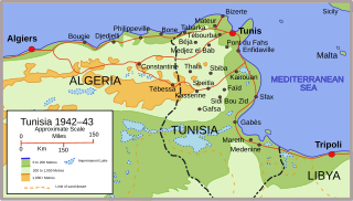
The Battle of Kasserine Pass took place from 18-24 February 1943 at Kasserine Pass, a 2-mile-wide (3.2 km) gap in the Grand Dorsal chain of the Atlas Mountains in west central Tunisia. It was a part of the Tunisian campaign of World War II.

<span class="mw-page-title-main">Tunisian campaign</span> Series of battles in Tunisia during the Second World War

The Tunisian campaign was a series of battles that took place in Tunisia during the North African campaign of the Second World War, between Axis and Allied forces from 17 November 1942 to 13 May 1943. The Allies consisted of British Imperial Forces, including a Greek contingent, with American and French corps. The battle opened with initial success by the German and Italian forces but the massive supply interdiction efforts led to the decisive defeat of the Axis. Over 250,000 German and Italian troops were taken as prisoners of war, including most of the Afrika Korps.

<span class="mw-page-title-main">Battle of El Guettar</span> 1943 battle of World War II

The Battle of El Guettar was a battle that took place during the Tunisia Campaign of World War II, fought between elements of the Army Group Africa under General Hans-Jürgen von Arnim, along with Italian First Army under General Giovanni Messe, and U.S. II Corps under Lieutenant General George Patton in south-central Tunisia. It was the first battle in which U.S. forces were able to defeat the experienced German tank units, but the followup to the battle was inconclusive.

This is a timeline of the North African campaign.

<span class="mw-page-title-main">Battle of the Mareth Line</span> Battle of World War II fought in Tunisia

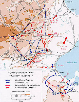
The Battle of the Mareth Line or the Battle of Mareth was an attack in the Second World War by the British Eighth Army in Tunisia, against the Mareth Line held by the Italo-German 1st Army. It was the first big operation by the Eighth Army since the Second Battle of El Alamein 4+12 months previously. On 19 March 1943, Operation Pugilist, the first British attack, established a bridgehead but a break-out attempt was defeated by Axis counter-attacks. Pugilist established an alternative route of attack and Operation Supercharge II, an outflanking manoeuvre via the Tebaga Gap was planned. Montgomery reinforced the flanking attack, which from 26 to 31 March, forced the 1st Army to retreat to Wadi Akarit, another 40 mi (64 km) back in Tunisia.

<span class="mw-page-title-main">Battle of Medenine</span> 1943 Allied offensive within the Tunisia campaign of WWII

The Battle of Medenine was an Axis spoiling attack at Medenine in Tunisia on 6 March 1943. The operation was intended to delay an attack by the British Eighth Army on the Mareth Line. The British had been forewarned by Ultra decrypts of German wireless communications and rushed reinforcements from Tripoli and Benghazi before the Axis attack, which was a costly failure. General Erwin Rommel, the commander of Army Group Africa (Heeresgruppe Afrika), could not afford to lose forces needed for the defence of the Mareth Line and the effort was abandoned at dusk that day.

The 69th Infantry Brigade was an infantry brigade of the British Army in the Second World War. It was a second-line Territorial Army formation, and fought in the Battle of France with the 23rd (Northumbrian) Division. The brigade was later part of the 50th (Northumbrian) Infantry Division. It went on to fight in the North African campaign, the Allied invasion of Sicily, the Normandy landings and the North West Europe campaign.

<span class="mw-page-title-main">Battle of Sidi Bou Zid</span> 1943 battle of the Tunisia Campaign in World War II

The Battle of Sidi Bou Zid(Unternehmen Frühlingswind/Operation Spring Breeze) took place during the Tunisia Campaign from 14–17 February 1943, in World War II. The battle was fought around Sidi Bou Zid, where a large number of US Army units were mauled by German and Italian forces. It resulted in the Axis forces recapturing the strategically important town of Sbeitla in central Tunisia.

<span class="mw-page-title-main">101st Motorized Division "Trieste"</span> Motorized Division of the Royal Italian Army

101st Motorized Division "Trieste" was a motorized infantry division of the Royal Italian Army during World War II. The Trieste was formed in 1939 and named for the city of Trieste. The division and its infantry and artillery regiments were based in Piacenza, while the 9th Bersaglieri Regiment was based until 1940 in Treviso and then moved to Cremona to be closer to the division. In September 1941 the Trieste was transferred to Libya for the Western Desert Campaign. The division was decimated in the Second Battle of El Alamein, but was rebuilt with the survivors of destroyed divisions. The Trieste then participated in the Tunisian Campaign until Axis forces in Tunisia surrendered to allied forces on 13 May 1943.

<span class="mw-page-title-main">80th Infantry Division "La Spezia"</span> Military unit

80th Infantry Division "La Spezia" was an infantry division of the Royal Italian Army during World War II. The La Spezia was formed on 15 November 1941 and named for the city of La Spezia. The La Spezia division was the only air-transportable division of the army and earmarked for the planned invasion of Malta. In November 1942 the division was sent to Libya to participate in the North African Campaign. On 13 May 1943 the La Spezia surrendered to Allied forces in Tunisia.

<span class="mw-page-title-main">16th Infantry Division "Pistoia"</span> Military unit

The 16th Infantry Division "Pistoia" was an infantry division of the Royal Italian Army during World War II. The division was named after the city of Pistoia and initially an infantry division, but reorganized to a fully motorized division in 1941. Consequently on 10 October 1941 the division was renamed 16th Motorized Division "Pistoia". The Pistoia had its recruiting area in the central Emilia-Romagna and its headquarters in Bologna. Its two infantry regiments were based in Bologna (35th) and Modena (36th), with the division's artillery regiment based in Bologna.

<span class="mw-page-title-main">Run for Tunis</span>

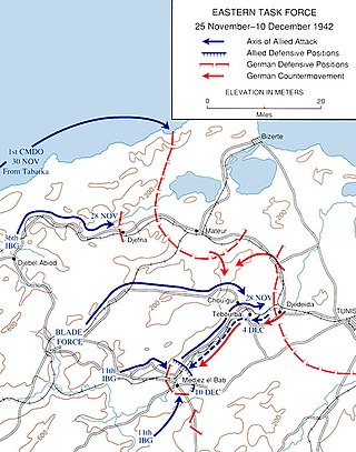
The Run for Tunis was part of the Tunisia Campaign which took place during November and December 1942 during the Second World War. Once French opposition to the Allied Operation Torch landings had ceased in mid-November, the Allies made a rapid advance by a division-sized force east from Algeria, to capture Tunis and forestall an Axis build up in Tunisia and narrowly failed. Some Allied troops were fewer than 20 miles (32 km) short of Tunis by late November but the defenders counter-attacked and pushed them back nearly 20 miles (32 km), to positions which had stabilised by the end of the year.

The 136th Armored Division "Giovani Fascisti" was an infantry division of the Royal Italian Army during World War II.

<span class="mw-page-title-main">Tebaga Gap</span>

The Tebaga Gap of southern Tunisia is a low mountain pass located in rough rocky broken country giving entry to the inhabited coastal plain to the north and east from much less hospitable desert dominated terrain in southern and south-western Tunisia.

<span class="mw-page-title-main">Battle of Wadi Akarit</span>

The Battle of Wadi Akarit was an Allied attack from 6 to 7 April 1943, to dislodge Axis forces from positions along the Wadi Akarit in Tunisia during the Tunisia Campaign of the Second World War. The Gabès Gap, north of the towns of Gabès and El Hamma, is a passage between the sea and impassable salt marshes. The 51st (Highland) Infantry Division breached the defences and held a bridgehead, allowing the passage of their main force to roll up the Axis defences. After several determined counter-attacks, the Axis forces withdrew and the Eighth Army, under General Bernard Montgomery, pursued toward Tunis, until reaching Axis defensive positions at Enfidaville.

<span class="mw-page-title-main">Battle of Longstop Hill</span>

The 2nd Battle of Longstop Hill or the Capture of Longstop Hill took place in Tunisia during the Tunisia Campaign of World War II from 21 to 23 April 1943. The battle was fought for control over the heights of Djebel el Ahmera and Djebel Rhar, together known as Longstop Hill and vicinity, between the British forces of the First Army and German units of the 5th Panzer Army. The infantry of the 78th Battleaxe Division and Churchill tanks of the North Irish Horse captured Longstop Hill after bitter fighting, in which the tanks created a measure of tactical surprise by driving up the hill, a manoeuvre that only Churchill tanks could achieve. The attackers broke through the German defences, which were the last great natural barrier on the road to Tunis.

Jebel Dahar is a low sandstone mountain chain of the Médenine Governorate of Tunisia.

<span class="mw-page-title-main">Operation Ochsenkopf</span>

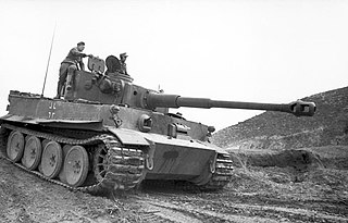
Unternehmen Ochsenkopf also known as the Battle of Sidi Nsir and the Battle of Hunts Gap was an Axis offensive operation in Tunisia from 26 February to 4 March 1943, during the Tunisia Campaign of the Second World War. The offensive and a subsidiary operation Unternehmen Ausladung was intended to gain control of Medjez el Bab, Béja, El Aroussa, Djebel Abiod and a position known as Hunt's Gap, between the British First Army and the Axis Army Group Africa. The offensive gained some ground, but none of the more ambitious objectives were achieved before the operation was called off due to increasing losses of infantry and tanks, particularly the heavy Tigers. Unternehmen Ochsenkopf was the last big Axis offensive by the 5th Panzer Army before the surrender of the Afrika Korps in May 1943.

<span class="mw-page-title-main">Mareth Museum</span> Museum in Mareth, Tunisia

Mareth museum is a military museum, in Mareth. Located between Gabes and Medenine, the Mareth line museum deals with the Second World War history. In March 1943, Rommel used this bunkered line to resist Montgomery's VIIIth army advance. The battle of the Mareth Line ensued. The Museum is built on a hill overlooking the Wadi Zigzaou, near several casemates which were strongpoints of the defensive line. Command posts, anti-tank and anti-aircraft guns are displayed outside the museum.

<span class="mw-page-title-main">Staffordshire Yeomanry, Royal Armoured Corps</span> Military unit

The Staffordshire Yeomanry, Royal Armoured Corps, was a tank regiment of Britain's Territorial Army converted from Yeomanry Cavalry serving in the Middle East during the Second World War. It fought at the Battles of Alam el Halfa and El Alamein in the Western Desert and the subsequent Tunisian campaign, distinguishing itself at the Battle of Tebaga Gap. It was then withdrawn to the UK to prepare for Operation Overlord, and landed on Sword Beach on D-Day. Subsequently, it was converted to operate amphibious tanks, and served in this role in the Battle of the Scheldt and the crossings of the Rhine and Elbe. Postwar, the Staffordshire Yeomanry remained part of the Royal Armoured Corps through various amalgamations.

References

Further reading