Marvel Peak

Last updated
Marvel Peak
Marvel Peak in Banff NP.jpg
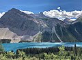
Marvel Peak seen from Wonder Pass area
Highest point
Elevation 2,708 m (8,885 ft) [1]
Prominence 488 m (1,601 ft) [1]
Parent peak Mount Byng (2965 m) [2]
Listing Mountains of Alberta
Coordinates 50°51′35″N115°33′05″W / 50.85972°N 115.55139°W / 50.85972; -115.55139 [3]
Geography
Canada Alberta relief location map - transverse mercator proj.svg
Red triangle with thick white border.svg
Marvel Peak
Location of Marvel Peak in Alberta
Canada relief map 2.svg
Red triangle with thick white border.svg
Marvel Peak
Marvel Peak (Canada)
Location Alberta, Canada
Parent range Blue Range [2]
Canadian Rockies
Topo map NTS 82J13 Mount Assiniboine [3]
Geology
Age of rock Cambrian
Type of rock Sedimentary rock

Marvel Peak is a 2,708- metre (8,885- foot ) mountain summit located in the southern tip of Banff National Park, in the Canadian Rockies of Alberta, Canada. Marvel Peak is situated in the Blue Range, three kilometers from the Continental Divide, and not visible from any road. Marvel Peak's nearest higher peak is Wonder Peak, 3.29 km (2.04 mi) to the north-northwest. [1]

Contents

History

Like so many of the mountains in and around Kananaskis Country, Marvel Peak received its name from the persons and ships involved in the 1916 Battle of Jutland, the only major sea battle of the First World War. [4] It was named in 1917 by the Interprovincial Boundary Survey after HMS Marvel which was a destroyer involved in the Battle of Jutland. [2] [5] An alternate view is the name is simply descriptive, similar to Wonder Peak to the north. [6] The mountain's toponym was officially adopted in 1934 by the Geographical Names Board of Canada. [3]

Geology

Like other mountains in Banff Park, Marvel Peak is composed of sedimentary rock laid down during the Precambrian to Jurassic periods. [7] Formed in shallow seas, this sedimentary rock was pushed east and over the top of younger rock during the Laramide orogeny. [8]

Climate

Based on the Köppen climate classification, Marvel Peak is located in a subarctic climate zone with cold, snowy winters, and mild summers. [9] Winter temperatures can drop below −20 °C (−4 °F) with wind chill factors below −30 °C (−22 °F). In terms of favorable weather, June through September are the best months to climb. Precipitation runoff from the mountain drains into Owl Creek and Marvel Creek, which find their way into Spray Lakes Reservoir.

See also

Related Research Articles

<span class="mw-page-title-main">Mount Chester</span> Mountain in Kananaskis, Alberta, Canada

Mount Chester is a mountain located in the Smith-Dorrien Creek Valley of Kananaskis in the Canadian Rockies. The mountain was named in 1917 after HMS Chester, which was severely damaged in the Battle of Jutland.

<span class="mw-page-title-main">Mount Hector (Alberta)</span> Mountain in Banff National Park, Alberta, Canada

Mount Hector is a 3,394-metre (11,135-foot) mountain summit located in the Bow River valley of Banff National Park, in the Canadian Rockies of Alberta, Canada. The mountain was named in 1884 by George M. Dawson after James Hector, a geologist on the Palliser expedition. The mountain is located beside the Icefields Parkway, 17 km (11 mi) north of Lake Louise.

<span class="mw-page-title-main">Mount Allen (Canada)</span> Mountain in Canada

Mount Allen is a mountain in the Canadian Rockies, on the Continental Divide, which forms the provincial boundary between British Columbia and Alberta in this region. J. Monroe Thorington named this mountain for Samuel Evans Stokes Allen in 1924. Allen was an American cartographer who mapped this area of the Rockies in 1894-95. Allen had named this mountain "Shappee", the Stoney language word for "six", as part of his naming of the ten mountains in the Valley of the Ten Peaks. The peak forms part of the backdrop to Moraine Lake in Banff National Park.

<span class="mw-page-title-main">Oppy Mountain</span> Mountain in Banff National Park, Canada

Oppy Mountain is located on the border of Alberta and British Columbia, North of the head of Lyell Creek. It was named in 1918 by interprovincial boundary surveyors after Oppy, a village in France. During World War I. the village had been captured by Germany in 1914. In May 1917, many Canadian soldiers were killed in the area during the Third Battle of the Scarpe.

<span class="mw-page-title-main">Wonder Peak</span> Mountain in the country of Canada

Wonder Peak is located on the border of Alberta and British Columbia in the Canadian Rockies. Situated on the Continental Divide, it also straddles the shared boundary of Banff National Park with Mount Assiniboine Provincial Park. It was named in 1913 by Arthur O. Wheeler and Conrad Kain.

Mount Allenby is a mountain summit in Alberta, Canada.

<span class="mw-page-title-main">Mount Black Prince (Alberta)</span> Mountain in Alberta, Canada

Mount Black Prince is a 2,939-metre (9,642-foot) mountain summit located in Peter Lougheed Provincial Park in the Canadian Rockies of Alberta, Canada. Its nearest higher peak is Mount Smith Dorrien, 5.8 km (3.6 mi) to the northwest. The mountain can be seen from Highway 742, also known as Smith-Dorrien/Spray Trail.

<span class="mw-page-title-main">Haddo Peak</span> Mountain peak in Banff NP, Canada

Haddo Peak is a summit in Alberta, Canada. Haddo Peak is located in the Lake Louise area of Banff National Park.

<span class="mw-page-title-main">Bow Peak</span> Mountain peak in Banff National Park, Alberta, Canada

Bow Peak is a 2,840-metre (9,320-foot) mountain summit located in the Bow River valley of Banff National Park, in the Canadian Rockies of Alberta, Canada. Its nearest higher peak is Crowfoot Mountain, 2.11 km (1.31 mi) to the east. Bow Peak is situated north of Hector Lake, southeast of Bow Lake, and can be seen from the Icefields Parkway. Although not of remarkable elevation, the mountain is a conspicuous landmark and visible from as far away as the Lake Louise area. Its position in the Waputik Mountains provides magnificent views from the summit.

<span class="mw-page-title-main">Mount Nestor (Alberta)</span> Mountain in Alberta, Canada

Mount Nestor is a 2,970-metre (9,740 ft) mountain summit located in Kananaskis Country in the Canadian Rockies of Alberta, Canada. It is named after HMS Nestor, a destroyer sunk in the Battle of Jutland during World War I. Mount Nestor is situated at the south end of the Goat Range along the west shore of Spray Lakes Reservoir. Nestor's east flank is within Spray Valley Provincial Park, while the west aspect is within Banff National Park, with the boundary line between the two parks running roughly north-to-south over its summit. The nearest higher peak is Old Goat Mountain, 2.0 km (1.2 mi) to the north. Mount Nestor can be seen from Alberta Highway 742, the Smith-Dorrien/Spray Trail.

<span class="mw-page-title-main">Tonsa</span> Mountain summit in Canada

Tonsa, or Tonsa Peak, is a 3,053-metre (10,016 ft) mountain summit located on the border of Alberta and British Columbia on the Continental Divide in the Canadian Rockies. The mountain forms part of the backdrop to Moraine Lake in the Valley of the Ten Peaks of Banff National Park. It was named in 1894 by Samuel E.S. Allen for the Stoney Indian word for the number four.

<span class="mw-page-title-main">Mount Shark</span> Mountain in Alberta, Canada

Mount Shark is a 2,786-metre (9,140-foot) mountain summit located in the Spray Valley of Kananaskis Country at the northern tip of the Spray Mountains range. It is situated on the southern boundary of Banff National Park in the Canadian Rockies of Alberta, Canada. Mount Shark in not visible from any road in Banff Park, however, it can be seen from Alberta Highway 742, also known as the Smith-Dorrien/Spray Trail. Mount Shark's nearest higher peak is Mount Smuts, 3.0 km (1.9 mi) to the southeast.

<span class="mw-page-title-main">Mount Smuts</span> Mountain in the country of Canada

Mount Smuts is a 2,938-metre (9,639-foot) mountain summit located in the Canadian Rockies of Alberta, Canada. It is set in the Spray Valley near the northern end of the Spray Mountains range. It is situated on the common boundary shared by Peter Lougheed Provincial Park with Banff National Park. Mount Smuts is not visible from any road in Banff Park, however it can be seen from Alberta Highway 742, also known as Smith-Dorrien/Spray Trail in Kananaskis Country. Mount Smuts' nearest higher neighbor is Mount Birdwood, 2.8 km (1.7 mi) to the south-southeast.

<span class="mw-page-title-main">Mount Morrison (Alberta)</span> Mountain in Banff NP, Alberta, Canada

Mount Morrison is a 2,765-metre (9,072-foot) mountain summit located in the upper Spray River Valley of southern Banff National Park, in the Canadian Rockies of Alberta, Canada. Mount Morrison in not visible from any road in Banff Park, however, it can be seen from Alberta Highway 742, also known as the Smith-Dorrien/Spray Trail in Kananaskis Country. Mount Morrison's nearest higher peak is Mount Turner, 1.8 km (1.1 mi) to the north.

<span class="mw-page-title-main">The Mitre (Alberta)</span> Mountain in Banff NP, Alberta, Canada

The Mitre is a 2,850-metre (9,350-foot) mountain summit located in the Lake Louise area of Banff National Park, in the Canadian Rockies of Alberta, Canada. Its nearest higher peak is Mount Lefroy, 1.0 km (0.62 mi) to the west. Mount Aberdeen is 2.0 km (1.2 mi) to the north-northeast, Lefroy Glacier immediately north, Mitre Glacier southwest, and Paradise Valley to the southeast.

<span class="mw-page-title-main">Hilda Peak</span> Mountain peak in Banff NP, Alberta, Canada

Hilda Peak is a 3,058-metre (10,033-foot) mountain summit located at the northern extreme of Banff National Park in the Canadian Rockies of Alberta, Canada. The nearest higher peak is Mount Athabasca, 2.0 km (1.2 mi) to the southwest. Hilda Peak is situated south of Sunwapta Pass and can be prominently seen from the Icefields Parkway. The Hilda Glacier lies to the south side of the peak, and the Boundary Glacier lies to the west.

<span class="mw-page-title-main">Portal Peak</span> Mountain in Banff NP, Alberta, Canada

Portal Peak is a 2,926-metre (9,600-foot) mountain summit located four kilometers west of Bow Lake in Banff National Park, in the Canadian Rockies of Alberta, Canada. Its nearest higher peak is Mount Thompson, 1.0 km (0.62 mi) to the northwest. Portal Peak is situated east of the Wapta Icefield, and is a member of the Waputik Mountains. Portal Peak can be seen from the Icefields Parkway at Bow Lake.

<span class="mw-page-title-main">Pulpit Peak</span> Mountain peak in Banff NP, Alberta, Canada

Pulpit Peak is a 2,720-metre (8,920-foot) mountain summit located one km south of Hector Lake in Banff National Park, in the Canadian Rockies of Alberta, Canada. Its nearest higher peak is Lilliput Mountain, 3.6 km (2.2 mi) to the southwest. Pulpit Peak is situated east of the Waputik Icefield, and is a member of the Waputik Mountains. Pulpit Peak can be seen from the Icefields Parkway towering 900 metres (2,950 ft) above Hector Lake.

<span class="mw-page-title-main">Silverhorn Mountain</span> Mountain in Banff NP, Alberta, Canada

Silverhorn Mountain is a 2,911-metre (9,551-foot) mountain summit located in the Mistaya River valley of Banff National Park, in the Canadian Rockies of Alberta, Canada. Silverhorn Mountain is situated 3.9 kilometres southeast of Mount Weed, and 3.1 km northwest of Observation Peak. Silverhorn stands directly east across the Mistaya River valley from Mount Patterson, and both are prominent features seen from the Icefields Parkway.

<span class="mw-page-title-main">Protection Mountain</span> Mountain in the Canadian Rockies of Alberta, Canada

Protection Mountain is a mountain in the Canadian Rockies of Alberta, Canada.

References

  1. 1 2 3 "Marvel Peak, Alberta". Peakbagger.com. Retrieved 2019-09-14.
  2. 1 2 3 "Marvel Peak". Bivouac.com. Retrieved 2019-02-05.
  3. 1 2 3 "Marvel Peak". Geographical Names Data Base . Natural Resources Canada . Retrieved 2019-02-05.
  4. Battle of Jutland Alberta Historic Places
  5. "Marvel Peak". cdnrockiesdatabases.ca. Retrieved 2019-09-14.
  6. Place-names of Alberta. Ottawa: Geographic Board of Canada. 1928. p. 84.
  7. Belyea, Helen R. (1960). The Story of the Mountains in Banff National Park (PDF). parkscanadahistory.com (Report). Ottawa: Geological Survey of Canada. Archived (PDF) from the original on 2015-10-02. Retrieved 2019-09-13.
  8. Gadd, Ben (2008). Geology of the Rocky Mountains and Columbias.
  9. Peel, M. C.; Finlayson, B. L.; McMahon, T. A. (2007). "Updated world map of the Köppen−Geiger climate classification". Hydrol. Earth Syst. Sci. 11 (5): 1633–1644. Bibcode:2007HESS...11.1633P. doi: 10.5194/hess-11-1633-2007 . ISSN   1027-5606.