
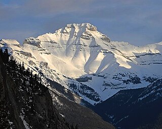
Mount Ball is a mountain located on the Continental Divide, on the borders of Banff and Kootenay national parks in Western Canada. Mt. Ball is the highest peak of the Ball Range in the Canadian Rockies.

Mount Girouard is the highest peak of the Fairholme Range in Banff National Park, Alberta, Canada. Mt. Girouard is located in the Bow River valley south of Lake Minnewanka.
Mount Inglismaldie is the second-highest peak of the Fairholme Range in Banff National Park. It is located immediately west of Mount Girouard in the Bow River valley south of Lake Minnewanka.

Mount Charles Stewart is a mountain located in the Bow River valley of Banff National Park in Canada.

Princess Margaret Mountain is a mountain located in the Bow River valley of Banff National Park, 2.5 km (1.6 mi) west of Mount Charles Stewart.
Mount Louis is a 2,682-metre (8,799-foot) mountain summit located in southeast Banff National Park in Alberta, Canada. It is part of the Sawback Range which is a subset of the Canadian Rockies.

Mount Hector is a 3,394-metre (11,135-foot) mountain summit located in the Bow River valley of Banff National Park, in the Canadian Rockies of Alberta, Canada. The mountain was named in 1884 by George M. Dawson after James Hector, a geologist on the Palliser expedition. The mountain is located beside the Icefields Parkway, 17 km (11 mi) north of Lake Louise.

Mount Sarbach is a mountain located in Banff National Park between Mistaya River and Howse River and is visible from the Icefields Parkway. The mountain is named after Peter Sarbach, a mountain guide from Switzerland, who guided the first ascent by J. Norman Collie and G.P. Baker in 1897. Mount Sarbach is situated south of Saskatchewan River Crossing, where the Icefields Parkway intersects with the David Thompson Highway.

Mount Astley is a 2,869-metre (9,413-foot) mountain summit located in the Palliser Range of the Canadian Rockies in Alberta, Canada. It is situated in Banff National Park above Lake Minnewanka. It was named after Charles D'Oyley Astley, who ran the boat concession on the lake in the late 1800s.

Mount Brett is a 2,984-metre (9,790-foot) summit located in the Massive Range of Alberta, Canada It is situated in Banff National Park, 20 km (12 mi) west of Banff townsite, in the Canadian Rockies. Its nearest higher peak is Mount Ball, 12.52 km (7.78 mi) to the west.

Neptuak Mountain was named by Samuel E.S. Allen in 1894. "Neptuak" is the Stoney Indian word for "nine" as Neptuak Mountain is peak #9 in the Valley of the Ten Peaks. It is located on the Continental Divide, which is also the British Columbia-Alberta border in this region, and is in the Bow Range of the Park Ranges of the Canadian Rockies. The summit is a tripoint for Banff National Park, Kootenay National Park, and Yoho National Park, where the three parks share a common border.

Mount Patterson is a peak in the Waputik Range of the Canadian Rockies. It is located within Banff National Park in Alberta of Western Canada. Mount Patterson stands across the Mistaya River Valley from Mount Weed, and both are prominent features seen from the Icefields Parkway. Its nearest higher peak is Howse Peak, 10.14 km (6.30 mi) to the northwest.

Mount Birdwood is a 3,097-metre (10,161-foot) summit in the Spray Mountains range of the Canadian Rockies in Alberta, Canada. The mountain is situated on the east boundary of Banff National Park in the upper Spray Lakes River Valley.

Mount Jimmy Simpson is a 2,966-metre (9,731-foot) summit located 3 kilometres northwest of Bow Lake in Banff National Park, in the Canadian Rockies of Alberta, Canada. Its nearest higher peak is Mount Thompson, 3.0 km (1.9 mi) to the southwest. Mount Jimmy Simpson is a member of the Waputik Mountains, and is situated east of the Wapta Icefield and west of the Bow River valley. Mount Jimmy Simpson can be seen from the Icefields Parkway at Bow Lake. Jimmy Simpson Junior is a 2,721 meter sub-summit east of the mountain.

Mount Lougheed is a 3,107-metre (10,194-foot) triple-peak mountain located between Spray Lakes Reservoir and the Wind Valley of Kananaskis Country in the Canadian Rockies of Alberta, Canada. The highest summit is known as Peak 2. Peak 1 to the northwest is 3,080 metres. Peak 3 to the southeast is 3,010 metres. The nearest higher peak is Wind Mountain, 2.0 km (1.2 mi) to the southeast. Mount Lougheed is a conspicuous landmark that can be seen from Highway 1, the Trans-Canada Highway at Dead Man's Flats which is east of Canmore.
Mount Huber is a 3,348-metre (10,984-foot) summit located two kilometres east of Lake O'Hara in the Bow Range of Yoho National Park, in the Canadian Rockies of British Columbia, Canada. The nearest higher neighbor is Mount Victoria, 1.0 km (0.62 mi) to the north-northeast on the Continental Divide. Mount Huber is a secondary summit of Mount Victoria.

Tonsa, or Tonsa Peak, is a 3,053-metre (10,016 ft) mountain summit located on the border of Alberta and British Columbia on the Continental Divide in the Canadian Rockies. The mountain forms part of the backdrop to Moraine Lake in the Valley of the Ten Peaks of Banff National Park. It was named in 1894 by Samuel E.S. Allen for the Stoney Indian word for the number four.

Mount Andromache is a 3,033-metre (9,951-foot) mountain summit located in the Bow River valley of Banff National Park, in the Canadian Rockies of Alberta, Canada. The nearest higher neighbor is Mount Hector, 4.00 km (2.49 mi) to the south. Mount Andromache can be seen from the Icefields Parkway as the road traverses the western base of the peak. Topographic relief is significant as the summit rises 1,180 m (3,870 ft) above the parkway in 1.5 km (0.93 mi). The Molar Glacier is situated on the northeast aspect of the mountain. Precipitation runoff from Mount Andromache drains into tributaries of the Bow River.

Mount Howard Douglas is a 2,877-metre (9,439-foot) mountain summit located immediately east of the Banff Sunshine ski resort in Banff National Park of Alberta, Canada. It was named for Howard Douglas (1850-1929), a park superintendent credited with greatly expanding its size. The mountain's name was officially adopted in 1958 when approved by the Geographical Names Board of Canada. Its nearest higher peak is Mount Bourgeau, 4.55 km (2.83 mi) to the north-northwest.

Mount Bell is a 2,910-metre (9,550 ft) summit in Alberta, Canada.


