Mt. Lebanon Township, Allegheny County, Pennsylvania
Last updated
This article's lead section does not adequately summarize key points of its contents. Please consider expanding the lead to provide an accessible overview of all important aspects of the article. Please discuss this issue on the article's talk page.(December 2016)
Home Rule Municipality in Pennsylvania, United States
A Pennsylvania township or township under Pennsylvania laws is one class of the three types of municipalities codified, in Pennsylvania—smaller municipal class legal entities providing local self-government functions in the majority of land areas in the more rural regions. Townships act as the lowest level municipal corporations of governance of the Commonwealth of Pennsylvania, a U.S. state of the United States of America.
A home rule municipality in Pennsylvania is one incorporated under its own unique charter, created pursuant to the state's Home Rule and Optional Plans Law and approved by referendum. "Local governments without home rule can only act where specifically authorized by state law; home rule municipalities can act anywhere except where they are specifically limited by state law". Although many such municipalities have retained the word "Township" or "Borough" in their official names, the Pennsylvania Township and Borough Codes no longer apply to them. All three types of municipalities may become a home rule municipality.
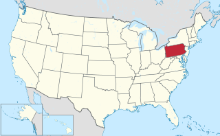
Allegheny County is a county in the southwest of the U.S. state of Pennsylvania. As of 2017 the population was 1,223,048, making it the state's second-most populous county, following Philadelphia County. The county seat is Pittsburgh. Allegheny County is included in the Pittsburgh, PA Metropolitan Statistical Area, and in the Pittsburgh Designated Market Area.
Established in 1912 as "Mount Lebanon," the community's official name was changed to "Mt. Lebanon" when its home rule charter took effect in 1975.
History
The first settlers arrived in 1773-1774, having purchased the land from the descendants of William Penn; other pioneers soon bought land from the state government.
William Penn was the son of Sir William Penn, and was an English nobleman, writer, early Quaker, and founder of the English North American colony the Province of Pennsylvania. He was an early advocate of democracy and religious freedom, notable for his good relations and successful treaties with the Lenape Native Americans. Under his direction, the city of Philadelphia was planned and developed.
In 1912, Mount Lebanon Township was incorporated as a "First Class Township" under Pennsylvania state law. It had formerly been a part of Scott Township, which in turn traces its origins to the long-defunct St. Clair Township. Mount Lebanon was not named for two Cedar of Lebanon trees that were planted in 1850 on Washington Road near the top of Bower Hill Road, but was named after the area from which they came, Mount Lebanon, due to the similarities between the two landscapes.[4] Prior to the incorporation of the township, the "Mount Lebanon" name was used for the area of Upper St. Clair Township near the cedar trees. In the 1880s, a post office located near the transplanted cedar trees was named "Mount Lebanon". Incorporators of neighboring Dormont Borough initially tried to use the "Mount Lebanon" name in 1909, but were opposed by residents of the future Mount Lebanon Township.
Pennsylvania, officially the Commonwealth of Pennsylvania, is a state located in the northeastern, Great Lakes and Mid-Atlantic regions of the United States. The Appalachian Mountains run through its middle. The Commonwealth is bordered by Delaware to the southeast, Maryland to the south, West Virginia to the southwest, Ohio to the west, Lake Erie and the Canadian province of Ontario to the northwest, New York to the north, and New Jersey to the east.
Scott Township is a township in Allegheny County, Pennsylvania, United States. The population was 17,024 at the 2010 census.
Mount Lebanon is a mountain range in Lebanon. It averages above 2,500 m (8,200 ft) in elevation.
In 1928, Mount Lebanon became the first First Class township in Pennsylvania to adopt the council-manager form of government and has had an appointed manager serving as the chief administrative officer since that time.
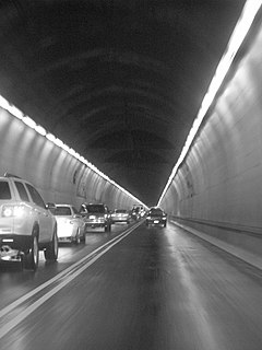
Mount Lebanon was a farming community until the arrival of streetcar lines, the first line to Pittsburgh opening on July 1, 1901[5] followed by a second in 1924. After the arrival of the streetcar lines, which enabled daily commuting to and from Downtown Pittsburgh, Mount Lebanon became a streetcar suburb, with the first real estate subdivision being laid out in November 1901. Further, the opening of the Liberty Tubes in 1924 allowed easy automobile access to Pittsburgh. Between the 1920 and 1930 censuses, the township's population skyrocketed from 2,258 to 13,403. Today, Pittsburgh's mass transit agency, the Port Authority of Allegheny County, or "PATransit," operates a light rail system whose Red Line, which runs underneath Uptown Mt. Lebanon through the Mt. Lebanon Tunnel, merges with the 47L line in Pittsburgh's Mt. Washington section. Mt. Lebanon's only platform station, Mt. Lebanon Station, is in Uptown Mt. Lebanon; the adjacent Dormont Junction and Castle Shannon stations are in neighboring municipalities. And as of the census[6] of 2000, there were 33,017 people living in Mt. Lebanon.
Downtown Pittsburgh, colloquially referred to as the Golden Triangle, and officially the Central Business District, is the urban downtown center of Pittsburgh. It is located at the confluence of the Allegheny River and the Monongahela River whose joining forms the Ohio River. The "triangle" is bounded by the two rivers. The area features offices for major corporations such as PNC Bank, U.S. Steel, PPG, Bank of New York Mellon, Heinz, Federated Investors and Alcoa. It is where the fortunes of such industrial barons as Andrew Carnegie, Henry Clay Frick, Henry J. Heinz, Andrew Mellon and George Westinghouse were made. It contains the site where the French fort, Fort Duquesne, once stood.
A streetcar suburb is a residential community whose growth and development was strongly shaped by the use of streetcar lines as a primary means of transportation. Early suburbs were served by horsecars, but by the late 19th century cable cars and electric streetcars, or trams, were used, allowing residences to be built further away from the urban core of a city. Streetcar suburbs, usually called additions or extensions at the time, were the forerunner of today's suburbs in the United States and Canada. Western Addition in San Francisco is one of the best examples of streetcar suburbs before westward and southward expansion occurred.
The Liberty Tunnels are a pair of tunnels located in Pittsburgh, Pennsylvania, United States that allow motorists to travel between the South Hills of Pittsburgh and the city, beneath Mt. Washington. The tunnels were vital in the expansion of the South Hills suburbs by providing a direct route to the city, eliminating the time-consuming task of navigating around or over Mt. Washington and its inclines. Opening in 1924, the Liberty Tunnels are the longest automobile tunnel in the City of Pittsburgh.
In 1971, Muhammad Ali attempted to purchase a home in Virginia Manor, but racial discrimination prevented him from doing so.[7] However, current and former residents claim that the rejection was due to the anticipated publicity and crowds which would result from the sale of the property to Mr. Ali.
Muhammad Ali was an American professional boxer, activist, and philanthropist. He is nicknamed "The Greatest" and is widely regarded as one of the most significant and celebrated sports figures of the 20th century and as one of the greatest boxers of all time.
On May 21, 1974, the electorate approved a Home RuleCharter, which took effect on January 1, 1975;[8] as such, the community is no longer governed under the provisions of the Pennsylvania Township Code. Mount Lebanon became one of the first municipalities in Pennsylvania to adopt a home rule charter.[9] In the charter, the official name of the municipality became Mt. Lebanon, Pennsylvania; the word "Mount" is abbreviated in all government documents, although the U.S. Postal Service continues to use "Mount."
St. Clair Hospital on Bower Hill Road
The subdivision of Carelton Hills won a national liveability award in 1974.[10]
Mt. Lebanon is a suburb of Pittsburgh7 miles (11km) south of the city's downtown. There are two small borders with Pittsburgh neighborhoods to the northeast (Brookline) and north (Banksville). The remainder of the northeast border is with the borough of Dormont. The entire western border is with Scott Township. To the south are the two towns which, due to their comparable size and affluence, are most often compared with Mt. Lebanon: Upper St. Clair to the southwest and Bethel Park to the southeast. To the east is Castle Shannon, and finally, to the east-northeast is Baldwin Township (not to be confused with the Borough of Baldwin).
Mt Lebanon United Methodist ChurchSouthminster Presbyterian Church
Commercial districts
Uptown Mt. Lebanon[12] is the central business district and has Washington Rd.[13] (U.S. Rt. 19 Truck) as its main thoroughfare. (U.S. Rt. 19 Truck continues into Pittsburgh and back out into the city's northern suburbs and beyond.) Uptown Mt. Lebanon is one of the more built up central business districts outside of Pittsburgh, featuring numerous coffee shops, small galleries, pizzerias, and clothing boutiques. The neighborhood is organized as The Uptown Mt. Lebanon Business and Professional Association.[14]
There are sizable business districts along the borders with Upper St. Clair and Castle Shannon, as well.
Communities within Mt. Lebanon
Neighborhoods within Mt Lebanon include: Beverly Heights, Cedarhurst Manor, Hoodridge Hilands, Mission Hills, Sunset Hills, Virginia Manor, Twin Hills, and Woodridge.
Virginia Manor is an affluent subdivision,[15] with streets designed to follow the natural contours of the land.[15] Future Governor James H. Duff helped found Virginia Manor in 1929.[16]
As of the census[6] of 2000, there were 33,017 people, 13,610 households, and 9,023 families residing in the township. The population density was 5,457.2 people per square mile (2,107.1/km²). There were 14,089 housing units at an average density of 2,328.7 per square mile (899.1/km²). The racial makeup of the township was 96.21% White, 0.61% Black, 0.07% Native American, 2.29% Asian, 0.01% Pacific Islander, 0.18% from other races, and 0.62% from two or more races. Hispanic or Latino of any race were 0.80% of the population.
There were 13,610 households, out of which 31.3% had children under the age of 18 living with them, 57.3% were married couples living together, 7.2% had a female householder with no husband present, and 33.7% were non-families. 30.6% of all households were made up of individuals, and 13.5% had someone living alone who was 65 years of age or older. The average household size was 2.37 and the average family size was 3.00. The median age was 42 years.
In the township the population was spread out, with 24.8% under the age of 18, 4.0% were 18 to 24, 26.9% were 25 to 44, 25.4% were 45 to 64, and 18.8% were 65 years of age or older. For every 100 females, there were 87.1 males. For every 100 females age 18 and over, there were 82.1 males.
The median income for a household in the township was $60,783, and the median income for a family was $79,744 (these figures had risen to $73,765 and $98,731 respectively as of a 2007 estimate.[21]) Males had a median income of $56,183 versus $37,008 for females. The per capita income for the township was $33,652. About 2.2% of families and 3.5% of the population were below the poverty line, including 2.9% of those under age 18 and 4.8% of those age 65 or over.
The district has seven elementary schools: Foster Elementary School, Hoover Elementary School, Howe Elementary School, Jefferson Elementary School, Lincoln Elementary School, Markham Elementary School, and Washington Elementary School. The two middle schools are Jefferson Middle School and Andrew W. Mellon Middle School. There is one high school: Mt. Lebanon High School. The district has won multiple National Blue Ribbon School awards.[24] The high school was rated as one of the Top 500 high schools in the United States by Newsweek in 2000 and 1st in Western Pennsylvania by the Pittsburgh Business Times in 2005.[25]
The Mt. Lebanon Public Library, founded in 1932, is funded almost entirely by the municipality and county. Its home is a $4.2 million building, with shelves for 140,000 books, seats for 165 persons, and more than 50 public computers. When the building opened in 1997, it won an architectural design award and was featured in the architectural issue of Library Journal.[26]
Taxes
School tax millage rate- The Mt. Lebanon School District in 2017 was 23.93. This ranked 13th highest/most expensive out of Allegheny County's 45 school districts [between Sto-Rox SD (#12) and Highlands SD (#14)].[27]
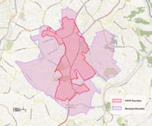
Historic District
Approximate historic district boundaries
A large portion of Mt. Lebanon was listed as the Mt. Lebanon Historic District on the National Register of Historic Places in 2014. The district contains 3,341 contributing buildings and 21 contributing sites. Most of the buildings (89%) are residential, though two commercial areas are included.[28]
The district is a significant example of the transition from a rural agricultural area to a suburb made possible first by the trolley/streetcar, c.1901, and later by the automobile in the 1920s and 1930s with the opening of the Liberty Tubes in 1924. The boundaries of the district include those areas that were developed between 1874 and c.1945.[28]
Mt. Lebanon provides many recreational opportunities for its residents. Fifteen parks are scattered over 200 acres (0.81km2) throughout the community. In addition to the parks, there is an Olympic size swimming pool, open in summer, and a regulation size ice rink and recreation building located adjacent to Mt. Lebanon Park on Cedar Blvd. Mt. Lebanon also boasts one of the oldest public golf courses in western Pennsylvania and has several tennis and basketball courts which are open year-round. Other recreational facilities include a Sand volleyball court, bocce courts, platform tennis, a plethora of picnic pavilions and over eight children's playgrounds.[29] Mt. Lebanon School District's sports teams are a big part of the community. The mascot is currently the Blue Devil, which has occasionally stirred controversy.[30]
Aleppo Township is a township in Allegheny County, Pennsylvania, United States. The population was 1,916 at the 2010 census.
Baldwin Township is a township in Allegheny County, Pennsylvania, United States. The population was 1,992 at the 2010 census.
Brackenridge is a borough in Allegheny County in the U.S. state of Pennsylvania, along the Allegheny River. It is part of the Pittsburgh Metro Area.
Castle Shannon is a borough in Allegheny County, Pennsylvania, United States, and is part of the Pittsburgh Metro Area. The population was 8,316 at the 2010 census.
Dormont is a borough in Allegheny County, Pennsylvania, United States and is part of the Pittsburgh Metro Area. The population was 8,593 at the 2010 census. Dormont is a home to a diverse population including young professionals, working families, and retirees. Dormont's economic stability can be attributed to this diversity along with its close proximity to jobs in Downtown Pittsburgh, access to The "T", diverse housing stock, and historically low crime rates. Dormont is mixed use and urban and features a pedestrian friendly business district, with bars, coffee shops, restaurants, and retail stores. It is famous for one of the largest municipal pools in Pennsylvania, the historic Dormont Pool. Loosely translated, Dormont means "Mountain of Gold" in French.
Findlay Township is a township located west of Pittsburgh in Allegheny County, Pennsylvania, United States. The population was 5,060 at the 2010 census.
Marshall Township is a township in Allegheny County, Pennsylvania, United States. The population was 6,915 at the 2010 census. Marshall Township was named for Thomas M. Marshall, who was instrumental in the township's organization. Since the late 1960s it has been home to a large research and business park.
Ohio Township is a township of the Second Class in Allegheny County, Pennsylvania, United States. Ohio Township elects a board of three (3) Supervisors, a property tax collector, and a constable. The day to day business of the township is managed by a Township Manager serving at will. In addition to the Administration Office, the Police Department, Road Department, and Recreation Department are also under the direct administration of the Board of Supervisors. The Ohio Township Police Department provides full-time service, not only for Ohio Township, but through contractual agreements also for the Townships of Aleppo, Kilbuck, and Neville and the Boroughs of Ben Avon, Ben Avon Heights, Emsworth and Sewickley Hills.
Penn Hills is a township with home rule status in Allegheny County, Pennsylvania, United States. The population as of the 2010 census was 42,329. Penn Hills is the second-largest municipality in Allegheny County, after the city of Pittsburgh.
Plum is a borough in Allegheny County in the U.S. state of Pennsylvania. A suburb of Pittsburgh, Pennsylvania, it is located northeast of the city of Pittsburgh, in what is commonly referred to as the East Hills suburbs. The population was 27,126 at the 2010 census.
Tarentum is a borough in Allegheny County in the U.S. state of Pennsylvania. It is 22 miles (35 km) northeast of Downtown Pittsburgh, along the Allegheny River. Tarentum was an industrial center where plate glass and bottles were manufactured; bricks, lumber, steel and iron novelties, steel billets and sheets, sack and wrapping paper were also produced. The Pennsylvania Railroad operated a station in Tarentum; its rail line ran through the town. The population was 4,530 at the 2010 census. Two statues of Hebe, the Greek goddess of youth, are displayed by the borough in Tarentum.
Upper St. Clair Township is a township with home rule status in Allegheny County, Pennsylvania, United States.
Hampton Township is a township in Allegheny County, Pennsylvania, United States. The population was 18,363 at the 2010 census.
Harrison Township is a township in Allegheny County in the U.S. state of Pennsylvania. The population was 10,461 at the 2010 census. Pennsylvania Route 28 passes through Harrison Township connecting Kittanning to the northeast and Pittsburgh to the southwest. Allegheny Technologies has extensive steel mill facilities in Harrison Township, including its Allegheny Ludlum Brackenridge Works. Harrison Township is located at the far northeast corner of Allegheny County. Its northern border is the Butler County line and the Allegheny River forms the township's eastern boundary with Westmoreland County. Its northeast corner also touches Armstrong County.
Reserve Township is a township in Allegheny County, Pennsylvania, United States. The population was 3,333 at the 2010 census.
Mt. Lebanon School District is the public school system in Allegheny County for residents of Mt. Lebanon, Pennsylvania, a suburb of Pittsburgh, Pennsylvania.
The Red Line is a line on the Pittsburgh Light Rail system that runs between South Hills Village and Downtown Pittsburgh via the Beechview neighborhood. The companion route, the Blue Line, branches off north of Martin Villa and runs through Overbrook. In March 2007, the closure of the Palm Garden Bridge for refurbishment suspended the Red Line for five months; it resumed service in September.
The 42nd Pennsylvania House of Representatives District is located in Southwest Pennsylvania and has been represented since 2013 by Dan Miller.
This page is based on this Wikipedia article Text is available under the CC BY-SA 4.0 license; additional terms may apply. Images, videos and audio are available under their respective licenses.