Newalla, Oklahoma

Last updated

Newalla
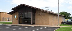
Post Office, Newalla, Oklahoma.jpg
Newalla Post Office
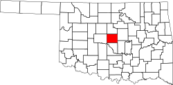
USA Oklahoma location map.svg
Red pog.svg
Newalla
Location within the state of Oklahoma
Usa edcp location map.svg
Red pog.svg
Newalla
Newalla (the United States)
Coordinates: 35°24′18″N97°9′46″W / 35.40500°N 97.16278°W / 35.40500; -97.16278
Country United States
State Oklahoma
County Oklahoma
Elevation
[1]
1,145 ft (349 m)
Time zone UTC-6 (Central (CST))
  Summer (DST) UTC-5 (CDT)
ZIP code
74857 [2]
Area code 405
GNIS feature ID1095849 [1]

Newalla is an unincorporated community in eastern Oklahoma County, Oklahoma, United States. Newalla is an adaption of the Osage name for the Canadian River. The post office was opened June 22, 1904.

Contents

Located just west of State Highway 270, north of Interstate 40, it is a part of the Oklahoma City Metropolitan Area.

Newalla, with a current elevation of 1,148 feet, is located within the Eastern bounds of Oklahoma County and appears on the Harrah, Oklahoma U.S. Geological Survey Map due to their proximity. Newalla is a geographic area which spans unincorporated Oklahoma County and unincorporated Cleveland County (also referred to as Little Axe). Portions of Newalla are also within Oklahoma City Limits. School districts that provide educational services to the community are the following: McLoud Public Schools, Harrah Public School, Choctaw Public Schools, Little Axe Public Schools, Mid-Del Public Schools, as well as Norman and Moore Public Schools. The estimated population of Newalla, Oklahoma is currently at 9,514.

Newalla has a site on the NRHP, being the Union School District 19 1/2 building. [3] This is an historically black two-room schoolhouse with a poured-in-place concrete, partial, two-room basement constructed circa 1936. [3] It is located at the southwest corner of 149th St. and S. Luther Rd. [3]

Sources

Shirk, George H.; Oklahoma Place Names; University of Oklahoma Press; Norman, Oklahoma; 1987: ISBN   0-8061-2028-2

Related Research Articles

<span class="mw-page-title-main">Grant Township, Keweenaw County, Michigan</span> Civil township in Michigan, United States

Grant Township is a civil township of Keweenaw County in the U.S. state of Michigan. The population was 275 at the 2020 census. Grant Township is one of the most isolated municipalities in Michigan, as it forms the tip of the Keweenaw Peninsula, which projects into Lake Superior.

<span class="mw-page-title-main">Salem Township, Washtenaw County, Michigan</span> Civil township in Michigan, United States

Salem Township is a civil township of Washtenaw County in the U.S. state of Michigan. The population was 5,627 at the 2010 census.

<span class="mw-page-title-main">Norman, Oklahoma</span> City in Oklahoma, United States

Norman is the third-most populous city in the U.S. state of Oklahoma, with a population of 128,026 as of the 2020 census. It is the most populous city and the county seat of Cleveland County and the second-most populous city in the Oklahoma City metropolitan area after the state capital, Oklahoma City, 20 miles north of Norman.

<span class="mw-page-title-main">Harrah, Oklahoma</span> City in Oklahoma, United States

Harrah is a city in Oklahoma County, Oklahoma, United States, and a part of the Oklahoma City metropolitan area. Located 25 miles (40 km) east of downtown Oklahoma City, Harrah had a population of 6,245 people as of the 2020 Census, a 22.6% increase from 2010.

<span class="mw-page-title-main">Newport, Michigan</span> Unincorporated community in Michigan, United States

Newport is an unincorporated community in Monroe County in the U.S. state of Michigan. The community is located within Berlin Charter Township. As an unincorporated community, Newport has no legally defined boundaries or population statistics of its own but does have its own post office with the 48166 ZIP Code.

<span class="mw-page-title-main">Acme, Michigan</span> Unincorporated community in Michigan, United States

Acme is an unincorporated community in Grand Traverse County in the U.S. state of Michigan. It is located on the shore of the East Arm of Grand Traverse Bay, is located within Acme Township. It is part of the urban area of Traverse City. Acme is home to the Grand Traverse Resort & Spa.

<span class="mw-page-title-main">Bay Shore, Michigan</span> Census-designated place & unincorporated community in Michigan, United States

Bay Shore is an unincorporated community and census-designated place (CDP) located on the boundary between Charlevoix County and Emmet County in the U.S. state of Michigan. The population of the CDP was 657 at the 2020 census.

Whitesboro is an unincorporated community and census-designated place (CDP) in Le Flore County, Oklahoma, United States. The population was 250 as of the 2010 census.

Bowring is an unincorporated community and Census Designated Place in Osage County, Oklahoma, United States. The post office was established November 12, 1923. It is said to have been named from the combination of the names of two local ranchers, Mart Bowhan and Richard Woodring.

Monroe is an unincorporated community and census-designated place in far eastern Le Flore County, Oklahoma, United States.

<span class="mw-page-title-main">Winn, Michigan</span> Census-designated place & unincorporated community in Michigan, United States

Winn is an unincorporated community and census-designated place (CDP) in Isabella County in the U.S. state of Michigan. The CDP had a population of 166 at the 2020 census. The community is located within Fremont Township.

<span class="mw-page-title-main">Bison, Oklahoma</span> Census-designated place in Oklahoma, United States

Bison is an unincorporated community and census-designated place (CDP) located on US Highway 81 in Garfield County, Oklahoma, United States, consisting of a 30-acre (12 ha) town plat. As of the 2010 census, it had a population of 65.

Blanco is a rural unincorporated community located on State Highway 63 in Pittsburg County, Oklahoma, United States. The ZIP code is 74528. The Census Bureau defined a census-designated place (CDP) for Blanco in 2015; the 2010 population within the 2015 CDP boundary is 96 and contains 52 housing units.

<span class="mw-page-title-main">Curran, Michigan</span> Unincorporated community in Michigan, United States

Curran is an unincorporated community in Alcona County in the U.S. state of Michigan. The community is located within Mitchell Township. As an unincorporated community, Curran has no legally defined boundaries or population statistics of its own but does have its own post office with the 48728 ZIP Code.

<span class="mw-page-title-main">Neal, Kansas</span> Unincorporated community in Greenwood County, Kansas

Neal is an unincorporated community in eastern Greenwood County, Kansas, United States. As of the 2020 census, the population of the community and nearby areas was 37. It is located approximately 10 miles east of the city of Eureka along U.S. Route 54 highway.

Honobia is an unincorporated community on the border between western LeFlore County and eastern Pushmataha County, Oklahoma, United States, 15 miles southeast of Talihina.

<span class="mw-page-title-main">Scofield, Michigan</span> Unincorporated community in Michigan, United States

Scofield is an unincorporated community in Monroe County in the U.S. state of Michigan. The community is located within Exeter Township. As an unincorporated community, Scofield has no legally defined boundaries or population statistics of its own.

Woodford is an unincorporated community located in Carter County, Oklahoma, United States. The townsite plat and cemetery are located within Section 34, Township 2 South, Range 1 West of the Indian Meridian. Its elevation is 932 feet. The zipcode is 73401. Woodford has its own telephone exchange, serviced by the Chickasaw Telephone Company. Phone numbers in Woodford are in the format 580-561-XXXX. The Woodford area had its own school district in the past, but it was closed as the community dwindled in population. Students in the area today attend school in the nearby towns of Springer, Lone Grove, or Fox.

Vanoss is an unincorporated community in Pontotoc County, Oklahoma, United States. The community is located 10 miles west of Ada. The town was originally named Midland and was located a few miles away from its present location. When the Oklahoma Central Railroad was built, the townspeople moved the town so it would be next to the railroad, and they changed its name to Vanoss in honor of Salomon Frederik van Oss, who was a Dutch director and financier of the Oklahoma Central Railroad. Though little remains of the community, Vanoss Public Schools, including an elementary school, a middle school, and Vanoss High School, continue to serve the surrounding area.

Bache is an unincorporated community in Pittsburg County, Oklahoma, United States. The community is located on U.S. Route 270, 7 miles (11 km) east of McAlester.

References

  1. 1 2 U.S. Geological Survey Geographic Names Information System: Newalla, Oklahoma
  2. "Newalla ZIP Code". zipdatamaps.com. 2022. Retrieved November 11, 2022.
  3. 1 2 3 "National Register of Historic Places Registration Form" (PDF). National Park Service. Retrieved June 23, 2020.