
Leh is a city in the Indian Union territory of Ladakh. It is the largest city and the joint capital of Ladakh. Leh, located in the Leh district, was also the historical capital of the Kingdom of Ladakh. The seat of the kingdom, Leh Palace, the former residence of the royal family of Ladakh, was built in the same style and about the same time as the Potala Palace in Tibet. Since they were both constructed in a similar style and at roughly the same time, the Potala Palace in Tibet and Leh Palace, the royal residence, are frequently contrasted. Leh is at an altitude of 3,524 m (11,562 ft), and is connected via National Highway 1 to Srinagar in the southwest and to Manali in the south via the Leh-Manali Highway.

Kargil district is a district in Indian-administered Ladakh in the disputed Kashmir-region. It is one of the two districts comprising the Indian-administered union territory of Ladakh. The district headquarters are in the city of Kargil. The district is bounded by the Indian-administered union territory of Jammu and Kashmir to the west, the Pakistani-administered administrative territory of Gilgit–Baltistan to the north, Ladakh's Leh district to the east, and the Indian state of Himachal Pradesh to the south. Encompassing three historical regions known as Purig, Dras and Zanskar, the district lies to the northeast of the Great Himalayas and encompasses the majority of the Zanskar Range. Its population inhabits the river valleys of the Dras, Suru, Wakha Rong, and Zanskar.

Padum is the main town and the administrative centre of the Zanskar tehsil in Kargil district, Ladakh, India. Name after the Buddhist guru Padmasambhava, it was historically one of the two main capitals of the Zanskar Kingdom, the other being Zangla. It is 235 km (146 mi) via the link road from Kargil city. The new Nimmu–Padum–Darcha road connects Padum directly to Leh in the east and to Darcha in Himachal Pradesh.

Alchi is a village in the Leh district of Ladakh, India. It is located in the Likir tehsil, on the banks of the Indus River 70 km downstream from the capital Leh. Unlike the other gompas in Ladakh, Alchi is situated on lowland, not on a hilltop.

Ladakh is an administrative territory of India that has been under its control since 1947. The geographical region of Ladakh union territory is the highest altitude plateau region in India, incorporating parts of the Himalayan and Karakoram mountain ranges and the upper Indus River and valley.

Shingo La is a mountain pass in India, on the state boundary between Ladakh and Himachal Pradesh. It connects the Lahaul region of Himachal Pradesh with the Zanskar region of Ladakh. Nimmu-Padum-Darcha road, a strategic road with the unidirectional-twin-tube total-4-lane Shingo La Tunnel which is expected to be completed by 2025 will reduce the Manali to Kargil distance by 522 km, is being built on the pass to ensure an all-weather route to Ladakh, as an alternative to the Leh–Manali Highway.

Tourism is one of an economic contributor to the union territory of Ladakh in Northern India. The union territory is sandwiched between the Karakoram mountain range to the north and the Himalayas to the south and is situated at the height of 11,400 ft. Ladakh is composed of the Leh and Kargil districts. The region contains prominent Buddhist sites and has an ecotourism industry.

The Zanskar River is the first major tributary of the Indus River, equal or greater in volume than the main river, which flows entirely within Ladakh, India. It originates northeast of the Great Himalayan range and drains both the Himalayas and the Zanskar Range within the region of Zanskar. It flows northeast to join the Indus River near Nimo.

Upshi is a village and road junction on the Leh-Manali Highway in the union territory of Ladakh in India. It is located 47 km (29 mi) to the southeast of Leh along the Indus river valley and Tanglang La on the Leh-Manali highway. Gya is also to the south.

Khalatse, often written as Khaltse or Khalsi, is the headquarters of the eponymous subdivision, block and tehsil in the Leh district of Ladakh, India. It is located 95 km from Leh city on the old main road to Kargil, where it crosses the Indus over an iron bridge. Much of its importance is because it is the place where the road from Kashmir debouches into the Indus Valley.
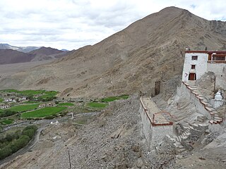
Nyoma is a principal village of southern Ladakh in India, the headquarters of an eponymous subdivision, tehsil, community development block and Indian Air Force Base in the Leh district. It is located on the bank of the Indus river after its 90-degree bend near Dungti east of Nyoma and before the valley narrows to a gorge near Mahe northwest of Nyoma. The Nyoma tehsil and subdivision cover all of southern Ladakh, including the Rupshu plains south of Nyoma, the Indus valley of Skakjung north of Nyoma, and the Hanle valley. Nyoma gompa, a Buddhist monastery, is located on the hill slope north of the village.

Karsha Monastery or Karsha Gompa is a Buddhist monastery in the Padum Valley of the Zanskar region of the union territory of Ladakh in northern India. The Doda River flows past the monastery from its source at the Drang Drung Glacier of the Pensi La. It was founded by the translator Phagspa Shesrab. The monastery, also known by the name Karsha Chamspaling, was founded by Phagspa Shesrab, under the Gelugpa Order or Yellow Hats. It is 11 km north of Padum in Zanskar River valley.

The Chadar Trek or the Zanskar Gorge trek is a winter trail over the frozen Zanskar River, which lies in the Indian union territory of Ladakh. It is traditionally the only means of travel in the area during the harsh winter months. The trail has become popular with foreign adventure tourists.
All Ladakh Gonpa Association (ALGA) is the central organisation of the Buddhist monasteries in Ladakh, India. It aims to preserve and strengthen the monastic institutions. It was founded by the 19th Kushok Bakula Rinpoche in 1949 and he acted as its president for 41 years, from 1949 until 1991. In 1949, the first meeting of the great monasteries was held and ten monasteries took part. All Ladakh Gonpa Association was registered in 1959 and is run by a governing body consisting of fifteen lama members belonging to all four major schools of Tibetan Buddhism. There are sixteen major monastic institutions with hundreds of monks in each monastery.
Chiling Sumda is a village in the Leh district of Ladakh, India. It is located Nimmu–Padum–Darcha road (NPDR) or Zanskar Highway in the Likir tehsil, on the bank of the Zanskar River in Zanskar region. It serves as a base camp for the Chadar Trek in the winters and is used to raft the Zanskar river in the summers.
Chuchot Gongma is a village-group and the headquarter of Chuchot block in the Leh district of Ladakh, India. It is located in the Leh tehsil. This village Chuchot is divided into three villages: Yokma, Shamma and Chuchot Gongma. Chuchot village is the longest village of ladakh. It starts from Choglamsar and stretches up to Stakna by the bank of the Indus River, and this river is the source of water for irrigating fields.

Gya or Gia is a village in the Leh district of Ladakh in India. It is located in the Kharu tehsil, off the Leh–Manali Highway, close to Tso Kar.

Hundar is a village in the Leh district of Ladakh, India, famous for sand dunes and Bactrian camels. It is located in the Nubra tehsil, on the banks of the Shyok River. The Hunder Monastery is located here.

Koyul is a village in the Leh district of Ladakh, India. It is located in the Nyoma tehsil, on the banks of the Koyul Lungpa river just before it joins the Indus River.

Nimmu–Padum–Darcha road (NPDR) or Zanskar Highway is a road between the Indian union territory of Ladakh and the state of Himachal Pradesh, passing through the region of Zanskar. It connects Nimmu in the Indus Valley to Padum, the capital of Zanskar, and to Darcha village in Lahul and Spiti. It provides an alternative to the Leh–Manali Highway in linking Ladakh with the rest of India. It was built by the Border Roads Organisation (BRO) of the Indian Army. The construction of road was completed in March 2024. The already completed Atal tunnel, and the proposed unidirectional-twin-tube total-4-lane Shingo La Tunnel, which is expected to be completed by 2025 will provide all weather connectivity and reduce the distance from Manali to Kargil by 522 km.


