Assam is a state in northeastern India, south of the eastern Himalayas along the Brahmaputra and Barak River valleys. Assam covers an area of 78,438 km2 (30,285 sq mi). It is the second largest state in northeastern India by area and the largest in terms of population, with more than 31 million inhabitants. The state is bordered by Bhutan and Arunachal Pradesh to the north; Nagaland and Manipur to the east; Meghalaya, Tripura, Mizoram and Bangladesh to the south; and West Bengal to the west via the Siliguri Corridor, a 22-kilometre-wide (14 mi) strip of land that connects the state to the rest of India. Assamese and Boro are the official languages of Assam. Meitei (Manipuri) is the official language of Hojai district and the entirety of the Barak Valley region, while Bengali is an official language in the three districts of Barak Valley.
Karbi Anglong district is an administrative unit in the Indian state of Assam. It is an autonomous district administered by the Karbi Anglong Autonomous Council (KAAC) according to the provisions of the Sixth Schedule of the constitution of India. The district headquarters is in Diphu.

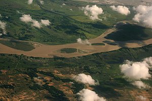
Jorhat is an administrative district of the Indian state of Assam situated in the central part of the Brahmaputra Valley. The district is bounded by Majuli on north, Nagaland state on the south, Sivasagar on the east and Golaghat on the west. On the north of the district, the river Brahmaputra forms the largest riverine island of the world. The administrative seat is at Jorhat city.
Sivasagar district, formerly known as Sibsagar, is one of the 34 districts of Assam state in Northeast India. Sivasagar city is the administrative headquarters of this district. This historic place is also known for its rich biodiversity. The districts covers an area of 2668 square kilometers. The district comprises two sub-divisions – Sivasagar and Nazira. The district of Sivasagar lies between 26.45°N and 27.15°N latitudes and 94.25°E and 95.25°E longitudes. The district is bounded by the Brahmaputra River to the north, Nagaland to the south, the Charaideo district to the east and the Jhanji River to the west. The Sivasagar district has acquired its distinct identity due to the co-existence of different races, tribes, languages and cultures.

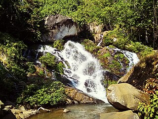
Bokakhat is a town in Assam and a Municipality Board in Golaghat district in the state of Assam, India. It is about 23 km away from the world heritage site Kaziranga National Park. Bokakhat town is situated almost in the middle of Assam. It is the headquarters of Bokakhat subdivision. The town is base to many nearby tourist places and is well connected to other cities and towns by road. The Kaipho Langso waterfall, an important picnic spot surrounded with magnificent views, lies in Karbi Anglong 13 km away from Bokakhat. Other nearby attractions include the ruins of the ancient Numaligarh and the Deoparbat, the tea gardens of Hatikhuli, Methoni, Diffloo Behora and Borsapori and also the coffee and rubber plantations. The nearest airports are at Jorhat and Guwahati. The nearest railway stations are Badulipar and Furkating.
Mising is a Tani language spoken by the Mising people. There are 629,954 speakers, who inhabit mostly in the Dhemaji district, Lakhimpur, Sonitpur, Dibrugarh, Sibsagar, Jorhat, Majuli, Golaghat, Tinsukia districts of Assam and also some parts of Arunachal Pradesh. The primary literary body of Mising is known as 'Mising Agom Kébang '.

The state of Assam in India has five regional divisions, each comprising a number of districts. The person responsible for the administration of a division is designated as a Divisional Commissioner.

Assam is the main and oldest state in the North-East Region of India and as the gateway to the rest of the Seven Sister States. The land of red river and blue hills, Assam comprises three main geographical areas: the Brahmaputra Valley which stretching along the length of the Brahmaputra river, the Barak Valley extending like a tail, and the intervening Karbi Plateau and North Cachar Hills. Assam shares its border with Meghalaya, Arunachal Pradesh, Nagaland, Manipur, Tripura, Mizoram and West Bengal; and there are National Highways leading to their capital cities. It also shares international borders with Bhutan and Bangladesh and is very close to Myanmar. In ancient times Assam was known as Pragjyotisha or Pragjyotishpura, and Kamarupa.
Upper Assam is an administrative division of the state of Assam comprising the undivided Lakhimpur and Sivasagar districts, of the upper reaches of the Brahmaputra valley. The other divisions are: Lower Assam, North Assam and Hills and Barak Valley. The division is under the jurisdiction of a Commissioner, stationed at Jorhat.
Garampani Wildlife Sanctuary is a 6.05-square-kilometre (2.34 sq mi) wildlife sanctuary located in Karbi Anglong district, Assam, India. It was notified as a Wildlife Sanctuary in 1952 vide notification No, FR.199/52 dated 10/07/52.

Assam Cricket Association (ACA) is the governing body of the Cricket activities in the Assam state of India. It is affiliated to the Board of Control for Cricket in India. The headquarters of ACA is at the Assam Cricket Association Stadium, Barsapara, Guwahati. It administers Assam cricket team, Assam women's cricket team and its junior state teams.
The All Assam Chess Association is a registered chess association of the Assam state of India. It was formed in the late 1960s by Bodiyuz Zaman from Jorhat. The first president of the association was Kamakhya Prasad Tripathi. It is affiliated with the All India Chess Federation and officially accredited by the Fédération Internationale des Échecs, (FIDE).

Folk dances of Assam include the Bihu and the Bagurumba, the Bhortal, the Ojapali dance. Assam is home to many groups: Muslim, Indo-Aryan, Rabha, Bodo, Dimasa, Karbi, Mising, Sonowal Kacharis, Mishmi and Tiwa (Lalung) etc. These cultures come together to create an Assamese culture. Residents of the state of Assam are known as "Axomiya" (Assamese). Most tribes have their own language, although Assamese is the primary language of the state.
All Tai Ahom Students Union (ATASU) or Chom Hom Lik Hen Tai Ahom Tang Mung in Ahom language is a students' union in Assam, India.
The 2015 Assam State Premier League was the first season of the Assam State Premier League in its new format, and 8th as highest state-level league. The league was re-launched in May 2015 and was kicked off on 29 May, concluding with the final on 25 July.
The Brahmaputra floods refers to a catastrophic flood event that occurred in 2012 along the Brahmaputra River and its tributaries, as well as in subsequent years.
The 2018 Assam panchayat election were held in two phases, on 5 and 9 December 2018. The counting of votes started on 12 December and results were declared on 15 December. More than 15.6 million people were eligible to vote and voter turnout was over 78 per cent.