[[Sharon Hill (SEPTA trolley station)|Sharon Hill]] (D2/Route 102)"},"stations":{"wt":"52"},"routes":{"wt":"{{plainlist|\n*{{ric|SEPTA Metro|D1}}{{nbsp}}Route 101\n*{{ric|SEPTA Metro|D2}}{{nbsp}}Route 102\n}}"},"daily_ridership":{"wt":"Route 101:3,844
Route 102:3,888
(FY 2019){{cite web | title=Fiscal Year 2021 Service Plan Update| publisher=[[SEPTA]] | date=June 2020 | url=https://planning.septa.org/wp-content/uploads/2021/02/FY-2021_Service_Plan_Update.docx | page=24 | access-date=March 11,2022}}"},"website":{"wt":"{{url|septa.org/schedules/D}}"},"open":{"wt":"1906"},"operator":{"wt":"[[SEPTA]] [[SEPTA Suburban Division bus routes|Suburban Division]]"},"character":{"wt":"Surface ([[Level crossing|at-grade]])"},"linelength":{"wt":"{{convert|11.9|mi|abbr=out}}"},"stock":{"wt":"[[SEPTA K-car|SEPTA Series 100]]"},"gauge":{"wt":"{{RailGauge|pennsylvania|allk=on}}{{cite web|url=http://www.phillytrolley.org/1974history/2-3.html|page=2|title=The history of trolley cars and routes in Philadelphia|publisher=[[SEPTA]]|date=June 1,1974|access-date=June 11,2014|quote=An early city ordinance prescribed that all tracks were to have a gauge of 5' 2{{citefrac|1|4}}\".}}{{cite book|first1=George W.|last1=Hilton|first2=John Fitzgerald|last2=Due |url=https://books.google.com/books?id=J2zH-zcuU-MC&pg=PA51 |title=The Electric Interurban Railways in America|publisher=Stanford University Press|date=January 1,2000|isbn=9780804740142 |access-date=June 10,2014}}"},"map":{"wt":"{{switcher\n|{{maplink-road|from1=SEPTA Route 101.map|from2=SEPTA Route 102.map}}\n|Show interactive map\n|{{SEPTA Routes 101 and 102|inline=1}}\n|Show route diagram map\n}}"},"map_state":{"wt":""},"electrification":{"wt":"[[Overhead lines]]"}},"i":0}}]}" id="mwDQ">.mw-parser-output .infobox-subbox{padding:0;border:none;margin:-3px;width:auto;min-width:100%;font-size:100%;clear:none;float:none;background-color:transparent}.mw-parser-output .infobox-3cols-child{margin:auto}.mw-parser-output .infobox .navbar{font-size:100%}body.skin-minerva .mw-parser-output .infobox-header,body.skin-minerva .mw-parser-output .infobox-subheader,body.skin-minerva .mw-parser-output .infobox-above,body.skin-minerva .mw-parser-output .infobox-title,body.skin-minerva .mw-parser-output .infobox-image,body.skin-minerva .mw-parser-output .infobox-full-data,body.skin-minerva .mw-parser-output .infobox-below{text-align:center}@media screen{html.skin-theme-clientpref-night .mw-parser-output .infobox-full-data:not(.notheme)>div:not(.notheme)[style]{background:#1f1f23!important;color:#f8f9fa}}@media screen and (prefers-color-scheme:dark){html.skin-theme-clientpref-os .mw-parser-output .infobox-full-data:not(.notheme) div:not(.notheme){background:#1f1f23!important;color:#f8f9fa}}@media(min-width:640px){body.skin--responsive .mw-parser-output .infobox-table{display:table!important}body.skin--responsive .mw-parser-output .infobox-table>caption{display:table-caption!important}body.skin--responsive .mw-parser-output .infobox-table>tbody{display:table-row-group}body.skin--responsive .mw-parser-output .infobox-table tr{display:table-row!important}body.skin--responsive .mw-parser-output .infobox-table th,body.skin--responsive .mw-parser-output .infobox-table td{padding-left:inherit;padding-right:inherit}}
The Media–Sharon Hill Line (MSHL), currently rebranding as the D, [lower-alpha 1] is a light rail line in the SEPTA Metro network serving portions of Delaware County, Pennsylvania. Service is operated by the Suburban Transit Division of the Southeastern Pennsylvania Transportation Authority. The line's eastern terminus is 69th Street Transportation Center in Upper Darby Township, Pennsylvania. After Drexel Hill Junction station, the line splits into two branches: D1/Route 101 runs to Media, while D2/Route 102 goes to Sharon Hill. Altogether, the two services operate on approximately 11.9 miles (19.2 km) of route. [5] The line is one of the few remaining interurban systems in the United States, along with the South Shore Line in Illinois and Indiana, the River Line in New Jersey, and the Norristown High Speed Line, also in the Philadelphia area.
Along with the Norristown High-Speed Line, formerly the Philadelphia and Western Railroad, the routes are the remaining lines of the Red Arrow Lines Trolley System once operated by the Philadelphia Suburban Transportation Company (successor to the Philadelphia and West Chester Traction Company); some local residents still call them "Red Arrow".
The line uses 29 Kawasaki Heavy Industries Rolling Stock Company Type K LRV cars similar to those used on the SEPTA subway–surface trolley lines. However, unlike the city cars, the Type K cars on Routes 101 and 102 are double-ended and use pantograph collection instead of trolley poles.
Route | Length [6] | South Terminal | North Terminal |
---|---|---|---|
D1/101 | 8.6 miles (13.8 km) | Media Orange Street at State Street | Upper Darby 69th Street Transportation Center |
D2/102 | 5.3 miles (8.5 km) | Sharon Hill Sharon Hill | |
The 101 and 102 run together on their exclusive right-of-way in Upper Darby to Drexel Hill Junction for approximately 2 miles (3.2 km), at which point they diverge.
Route 101 continues on its own right-of-way traveling west and southwest through Drexel Hill and Springfield with an important stop at the Springfield Mall before entering the street in Media. The 101 has double tracks to Woodland Avenue, then a single track to just before Pine Ridge, then enters the street at Providence Road in Media and runs on a single track the rest of the way. Cars in the street must yield to the trolley. The line terminates in the middle of the street just west of the Delaware County Courthouse.
Route 102 runs southeast from Drexel Hill Junction through Drexel Hill and Clifton Heights and then goes into the street in Aldan. After Aldan, it returns to its own right-of-way, then passes through Collingdale before terminating at Chester Pike in Sharon Hill. The 102 has double tracks until up to North Street in Collingdale, where the 102 returns to its own right-of-way, and after North Street, there is a single track until the end of the line.
Springfield Road contains two stops along both lines. Route 101 stops at Springfield Road in Springfield. Route 102 stops at Springfield Road in Clifton Heights, then joins this street until it moves onto Woodlawn Avenue through Aldan.
The Sharon Hill Line (Route 102) was originally built by the Philadelphia and West Chester Traction Company, and opened on March 15, 1906, and the Media Line (Route 101) was originally built by the same company, opening on April 1, 1913. [7] The lines were later bought by the Philadelphia Suburban Transit Company in 1954.
Besides Routes 101 and 102, there were also two other, now defunct, Red Arrow trolley lines. The direct ancestor of the SEPTA Route 104 bus line went to West Chester, splitting off from the rest of the system right after 69th Street Transportation Center onto West Chester Pike. The tracks continued all the way up West Chester Pike. West Chester trolleys were replaced by buses in 1954 due to widening of West Chester Pike; rush-hour trips to Westgate Hills lasted until 1958. Tracks remained in use for access to the Red Arrow's carbarn in Llanerch until SEPTA closed the barn in 1971; all tracks were soon removed except for a portion near 69th Street that SEPTA occasionally uses to store out-of service trolleys. The other now-defunct Red Arrow trolley line went to Ardmore until December 1966. It split from the West Chester line at Llanerch and continued on its own exclusive right-of-way. Much of the right-of-way still remains between Schauffele Plaza in Ardmore (the former terminus of the line) and Eagle Road in Havertown, although the tracks were removed and the right-of-way paved for dedicated use by the replacement bus line, now SEPTA Route 103. The 103 still uses this private right-of-way, although much of its other street routing has changed.
On April 1, 2020, service on Route 102 was suspended while Route 101 was substituted with buses due to the COVID-19 pandemic. Trolley service on both routes resumed June 1, 2020. [8] [9] [10]
In 2021, SEPTA proposed rebranding their rail transit service as "SEPTA Metro", to make the system easier to navigate. Under this proposal, the Media and Sharon Hill lines will be rebranded as the "D" lines (for "Delaware", the county in which the trolley routes are located) with a pink color and numeric suffixes for each service. The 101 and 102 will respectively be rebranded as the D1 69th St / Orange St and D2 69th St / Sharon Hill. [12] [11] After a period of public comment, SEPTA revised its plans to primarily refer to the line as the "D," as well as to rethink the name of the Route 101's "Orange Street" terminal station name. [13]
In 2023, SEPTA awarded Alstom Transportation the contract to furbish 130 new low-floor trolleys, with an option for 30 more. The trolleys will be of Alstom's Citadis family and will be 80 feet in length and fully ADA-compliant, which the current Kawasaki trolleys from the early 1980s are not. [14] The trolleys will be distributed among SEPTA's Routes 101 and 102 in Delaware County, and its subway-surface lines and Route 15 in neighboring Philadelphia. The first trolley is expected to be delivered from Alstom in the Spring of 2027, with the last trolley to be delivered sometime in 2030.
With SEPTA Trolley Modernization happening, SEPTA is proposing to extend Route 102 to Darby Transportation Center. This extension would connect Route 102 with SEPTA Route 11 and SEPTA Route 13.
Media is the western terminus of the Route 101 trolley line just west of the Orange Street intersection with State Street, the latter of which the trolley runs down the center line. Despite being located in the town, there is no direct connection to the Media station of the Media/Wawa Line which is a mile to the south on Orange Street and partly through a wooded area.
Location | Station/stop | Connections | Notes |
---|---|---|---|
Route 101 (Media branch) | |||
Media | Orange Street | ![]() ![]() | Route 101 western terminus |
Veterans Square | |||
Olive Street | |||
Jackson Street | ![]() ![]() | ||
Monroe Street | |||
Edgemont Street | |||
Manchester Avenue | |||
![]() | Begin right-of-way and two-track operation Formerly known as Bowling Green | ||
Beatty Road | |||
Springfield | ![]() | Tracks converge east of here | |
Paper Mill Road | Serves Smedley Park SEPTA's least used station [15] [16] | ||
![]() | ![]() ![]() | Formerly known as Sproul Road | |
Thomson Avenue | |||
Woodland Avenue | Resume two-track operation east of here | ||
Leamy Avenue | |||
Saxer Avenue | |||
![]() | |||
![]() | |||
Drexel Hill | ![]() | ||
Drexelbrook | |||
Anderson Avenue | |||
Aronimink | |||
School Lane | |||
Huey Avenue | |||
Route 102 (Sharon Hill branch) | |||
Sharon Hill | Sharon Hill | ![]() ![]() | Route 102 western terminus |
Collingdale | MacDade Boulevard | ![]() ![]() | Formerly known as Collingdale |
Andrews Avenue | |||
Bartram Avenue | |||
North Street | Tracks leave right-of-way and merge with Woodlawn Avenue north of here | ||
Aldan | Magnolia Avenue | ||
Providence Road | |||
Shisler Avenue | Station closed on March 15, 2010 | ||
Clifton Heights | Clifton-Aldan | ![]() ![]() | Tracks transition onto Springfield Road |
Springfield Road | Tracks leave Springfield Road for right-of-way south of here | ||
Penn Street | |||
Baltimore Avenue | ![]() ![]() | ||
Drexel Hill | Creek Road | Located in Indian Rock Park Formerly known as Oakview | |
Marshall Road | |||
Drexel Manor | |||
Garrettford | |||
Routes 101 & 102 (Common section) | |||
Drexel Hill | Drexel Hill Junction | ![]() ![]() | Also known as Shadeland Avenue Routes 101 and 102 diverge west of here |
Irvington Road | Bypassed by Route 101 rush hour express service | ||
Drexel Park | Bypassed by Route 101 rush hour express service Also called Fairfax Road | ||
Upper Darby | Lansdowne Avenue | ![]() ![]() | |
Congress Avenue | Bypassed by Route 101 rush hour express service | ||
Beverly Boulevard | Bypassed by Route 101 rush hour express service Formerly known as Beverly Hills | ||
Hilltop Road | Bypassed by Route 101 rush hour express service | ||
Avon Road | Bypassed by Route 101 rush hour express service Formerly known as Bywood | ||
Walnut Street | Bypassed by Route 101 rush hour express service | ||
Fairfield Avenue | Bypassed by Route 101 rush hour express service Tracks merge with street east of here | ||
69th Street T.C. | ![]() ![]() ![]() ![]() ![]() ![]() ![]() ![]() |
The Southeastern Pennsylvania Transportation Authority (SEPTA) is a regional public transportation authority that operates bus, rapid transit, commuter rail, light rail, and electric trolleybus services for nearly four million people throughout five counties in and around Philadelphia, Pennsylvania. It also manages projects that maintain, replace, and expand its infrastructure, facilities, and vehicles.
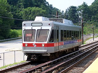
The Norristown High Speed Line (NHSL), currently rebranding as the M, is a 13.4-mile (21.6 km) interurban light rapid transit line in the SEPTA Metro network, running between the 69th Street Transportation Center in Upper Darby and the Norristown Transportation Center in Norristown, Pennsylvania. Service is operated by the Suburban Transit Division of the Southeastern Pennsylvania Transportation Authority. Originally the Philadelphia and Western Railroad line, the line runs entirely on its own right-of-way. By 2020, the Norristown High Speed Line had an average weekday ridership approaching 11,000 passengers.
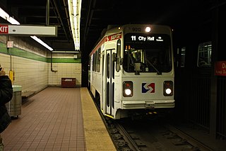
The Market–Frankford Line (MFL), currently rebranding as the L, is a rapid transit line in the SEPTA Metro network in Philadelphia, Pennsylvania, United States. The MFL runs from the 69th Street Transportation Center in Upper Darby, just outside of West Philadelphia, through Center City Philadelphia to the Frankford Transportation Center in Near Northeast Philadelphia. Starting in 2024, the line was rebranded as the "L" as part of the implementation of SEPTA Metro, wherein line names are simplified to a single letter.
Transportation in Philadelphia involves the various modes of transport within the city and its required infrastructure. In addition to facilitating intracity travel, Philadelphia's transportation system connects Philadelphia to towns of its metropolitan area and surrounding areas within the Northeast megalopolis.
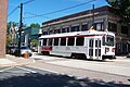
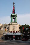
The 69th Street Transportation Center is a SEPTA terminal in the Terminal Square section of Upper Darby Township, Pennsylvania. It serves the Market–Frankford Line, Norristown High Speed Line, and SEPTA Routes 101 and 102 trolleys, and multiple bus routes. It is located at the end of 69th Street, a major retail corridor in Upper Darby Township across Market Street from the Tower Theater. Until 2011, the station was primarily known as 69th Street Terminal.
The SEPTA subway–surface trolley lines are a collection of five SEPTA trolley lines that operate on street-level tracks in West Philadelphia and Delaware County, Pennsylvania, and also underneath Market Street in Philadelphia's Center City. The lines, Routes 10, 11, 13, 34, and 36, collectively operate on about 39.6 miles (63.7 km) of route.
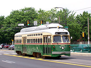
Route 15, currently rebranding as the G, is a street-running light rail line in the SEPTA Metro network that runs along Girard Avenue through North and West Philadelphia, Pennsylvania. Service is operated by the City Transit Division of the Southeastern Pennsylvania Transportation Authority. As of 2024, it is the only trolley line in Philadelphia that is not part of the subway–surface trolley lines. SEPTA PCC III vehicles are used on the line.
SEPTA Route 13, also known as the Chester Avenue Line, is a trolley line operated by the Southeastern Pennsylvania Transportation Authority (SEPTA) that connects 13th Street Station in downtown Philadelphia, Pennsylvania, with Yeadon and Darby, Pennsylvania. It is one of five lines that are part of the Subway-Surface Trolley system. Route 13 will be rebranded as the T3 as part of the transition to SEPTA Metro.
SEPTA's subway–surface trolley route 34, also called the Baltimore Avenue subway line, is a trolley line operated by the Southeastern Pennsylvania Transportation Authority (SEPTA) that connects the 13th Street station in downtown Philadelphia, Pennsylvania, to the Angora Loop station in the Angora neighborhood of West Philadelphia. Route 34 will be rebranded as the T2 as part of the transition to SEPTA Metro.
Pennsylvania Route 3 is a 24.3-mile (39.1 km) state highway located in the southeastern portion of Pennsylvania. The route runs from U.S. Route 322 Business in West Chester east to PA 611 in Philadelphia.
The Southeastern Pennsylvania Transportation Authority operates or contracts operations of these routes serving points in Bucks, Chester, Delaware, and Montgomery counties, with a few routes operating into the city of Philadelphia. The Suburban Transit Division is broken down into three districts: Victory, Frontier, and Contract Operations.
Drexel Hill Junction is a SEPTA Media-Sharon Hill Trolley Line station in Drexel Hill, Pennsylvania. It is located near Hillcrest Road and Shadeland Avenue, and serves both Routes 101 and 102. Drexel Hill Junction is the last stop where Routes 101 and 102 share the same right-of-way.
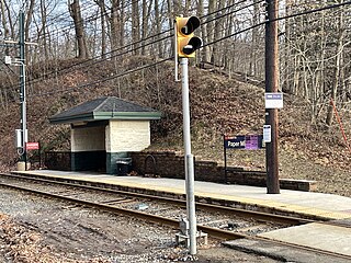
Paper Mill Road station is a SEPTA Route 101 trolley station in Springfield Township, Delaware County, Pennsylvania. It is located on Paper Mill Road at Smedley Park. Smedley Park named after Samuel L. Smedley, the local founder of the Delaware County Parks and Recreation Board.
Fairfield Avenue station is a SEPTA Media-Sharon Hill Trolley Line station in Upper Darby Township, Pennsylvania. It is officially located at Fairfield Avenue and Terminal Square, but the intersection also includes Bywood Avenue, which is a one-way street running west along the lines until the Beverly Boulevard station. The stop serves both Routes 101 and 102. Only local service is provided on both lines. This station is the penultimate stop on the Media-Sharon Hill Trolleys before reaching the 69th Street Terminal. The Upper Darby Post Office can be found on the north side of the station. The parking lot adjacent to the station is privately owned serving mainly a church and an H Mart.
Garrettford station is a SEPTA Route 102 trolley stop in Drexel Hill, Pennsylvania. It is officially located at Edmonds Avenue and Garrett Road, however, the actual location is at the intersection of Edmonds Avenue, Jones Street and Mill Lane, which is south of Garrett Road. The trolley line crosses the aforementioned intersection at the southwest corner of Edmonds Avenue and Jones Street, to the northeast corner of Edmonds Avenue and Mill Lane.
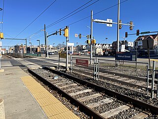
Walnut Street is a SEPTA Media-Sharon Hill Trolley Line stop in Upper Darby Township, Pennsylvania. It is officially located at Garrett Road and Walnut Street, but Bywood Avenue is also included as it parallels the north side of the line. The station serves both Routes 101 and 102, and only local service is provided on both lines. The station contains two platforms with plexiglass bus-type shelters on both sides of the tracks, both of which are at the far end of each platform.
Route 103 is a bus route operated by the Southeastern Pennsylvania Transportation Authority (SEPTA) on the outskirts of Philadelphia, Pennsylvania, United States. Route 103 runs between Ardmore and the 69th Street Transportation Center in Upper Darby.
Irvington Road station is a SEPTA Media-Sharon Hill Trolley Line stop in Drexel Hill, Pennsylvania. It is officially located near Irvington and Hillcrest Roads, but in reality it is nearly halfway between Hillcrest and Garrett Roads on Irvington Road. It serves both Routes 101 and 102, and only local service is provided on both lines. Irvington Road is the next to last stop where Routes 101 and 102 share the same right-of-way.
Drexel Park station is a SEPTA Media-Sharon Hill Trolley Line stop in Drexel Hill, Pennsylvania. It is located on Fairfax Road between Hillcrest and Garrett Roads and serves both Routes 101 and 102. Only local service is provided on both lines.
SEPTA Metro is an urban rail transit network in and around Philadelphia, Pennsylvania, United States, operated by the Southeastern Pennsylvania Transportation Authority (SEPTA). The network includes two rapid transit lines, a light rapid transit line, a surface-running trolley line, and a subway–surface trolley line, totaling 78 miles (126 km) of rail service.
An early city ordinance prescribed that all tracks were to have a gauge of 5' 21⁄4".