
The Springbrook National Park is a protected national park that is located in the Gold Coast hinterland of Queensland, Australia. The 6,197-hectare (15,310-acre) park is situated on the McPherson Range, near Springbrook, approximately 100 kilometres (62 mi) south of Brisbane. The park is part of the Shield Volcano Group of the UNESCO World Heritage–listed Gondwana Rainforests of Australia.

Geghard is a medieval monastery in the Kotayk province of Armenia, being partially carved out of the adjacent mountain, surrounded by cliffs. It is listed as a UNESCO World Heritage Site with enhanced protection status.

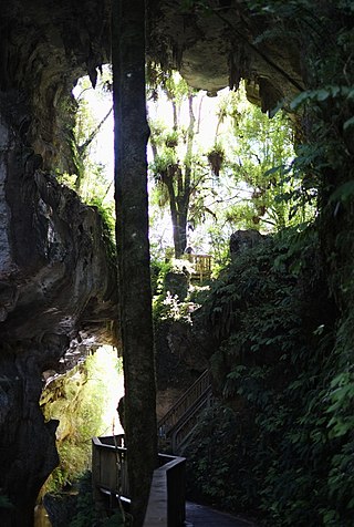
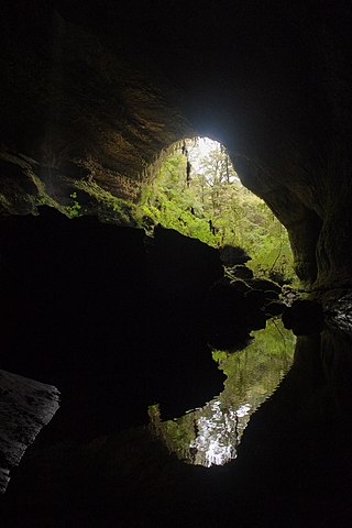
Nettlebed Cave is a limestone cave located in the Mount Arthur region of the northwest South Island of New Zealand. The presence of ongaonga, an endemic tree nettle, near the bottom entrance gives the cave its name.

Whatipu is a remote beach on the west coast of the Auckland Region in the North Island of New Zealand. The Whatipu area has been managed as a scientific reserve by the Auckland Regional Council since 2002. The road to it is unsealed. To the south of Whatipu is Manukau Harbour. To the north is Karekare. Whatipu is located at the southern end of the Waitākere Ranges. Shifting sands have substantially changed the beach since the 1940s. Over 6 square kilometres has been added to the beach since then.

The Jeita Grotto is a system of two separate, but interconnected, karstic limestone caves spanning an overall length of nearly 9 kilometres (5.6 mi). The caves are situated in the Nahr al-Kalb river valley within the locality of Jeita, 18 kilometres (11 mi) north of the Lebanese capital Beirut. Though inhabited in prehistoric times, the lower cave was not rediscovered until 1836 by Reverend William Thomson; it can only be visited by boat since it channels an underground river that provides fresh drinking water to more than a million Lebanese.

The Borra Caves(Borrā Guhalu) are located on the East Coast of India, in the Ananthagiri hills of the Araku Valley of the Alluri Sitharama Raju district in Andhra Pradesh. The caves, one of the largest in the country, at an elevation of about 705 m (2,313 ft), distinctly exhibit a variety of speleothems ranging in size and irregularly shaped stalactites and stalagmites. The caves are basically karstic limestone structures extending to a depth of 80 m (260 ft), and are considered the deepest caves in India. The native name for the caves is Borrā Guhalu where Borra means abdomen in and Guhalu means caves in Telugu language.

The Marble Arch Caves are a series of natural limestone caves located near the village of Florencecourt in County Fermanagh, Northern Ireland. The caves are named after the nearby Marble Arch, a natural limestone arch at the upstream end of Cladagh Glen under which the Cladagh River flows. The caves are formed from three rivers draining off the northern slopes of Cuilcagh mountain, which combine underground to form the Cladagh. On the surface, the river emerges from the largest karst resurgence in Ireland, and one of the largest in the United Kingdom. At 11.5 kilometres (7.1 mi) the Marble Arch Caves form the longest known cave system in Northern Ireland, and the karst is considered to be among the finest in the British Isles.

Alistrati is a small town in Serres, situated at the borders of the regional unit of Drama and regional unit of Serres, in the Macedonia region of Greece. It has approximately 2,300 inhabitants, a town hall and a visitable cave. It is 20 km away from Drama and 45 km away from Serres. It is a listed traditional settlement and archaeologists had found something there. Since 2010 Alistrati is part of the municipality New Zichni, of which it is a municipal unit. The municipal unit has an area of 129.878 km2. Alistrati was built like an amphitheatrical inside a fascinating mountain groups on hills of the mountain range Menikio on an altitude of 325m. In Alistrati there exists rising and sloping streets. Sea-winds blowing from Thassos and Staymonikon Bay influence Alistrati day by day. Alistrati, a traditional community one of the biggest of the area Zichni-Fillida. It's been up-graded to municipality of Alistrati with the "Kapodistrias" law and included the villages :Agioxori, Skopia, Mandili, Lefkothea and R.S of Aggista.

The Ōpārara River is a river in the West Coast region of New Zealand's South Island. It is best known for the limestone arches it carved in the Oparara Basin.

The Belum Caves, located in Nandyala district of Andhra Pradesh's Rayalaseema region, is the second largest cave system on the Indian subcontinent, known for its speleothems, such as stalactite and stalagmite formations. The Belum Caves have long passages, galleries, spacious caverns with fresh water and siphons. This cave system was formed over the course of tens of thousands of years by the constant flow of underground water from the now-disappeared river Chitravathi. The cave system reaches its deepest point at the point known as Pataalaganga. Belum Caves have a length of 3,229 m (10,593.8 ft), making them the second largest caves on the Indian Subcontinent after the Krem Liat Prah caves in Meghalaya. It is one of the centrally protected Monuments of National Importance.

The Lava River Cave near Bend, Oregon, is part of the Newberry National Volcanic Monument, which is managed by the United States Forest Service. At 5,211 feet (1,588 m) in length, the northwest section of the cave is the longest continuous lava tube in Oregon. While the cave's discovery in 1889 was officially credited to a pioneer hunter, the presence of obsidian flakes near the cave has led archaeologists to conclude that Native Americans knew about the cave long before settlers arrived in central Oregon.

The Grutas de Cacahuamilpa National Park in Guerrero, Mexico, is best known for the Grutas de Cacahuamilpa Caverns. It is also home to the Grutas of Carlos Pacheco, a smaller system, as well as two subterranean rivers which have carved out tunnels in the rock. The park has outdoor pursuit attractions such as rappelling, and rock climbing in Limontitla Canyon. as well as the two underground rivers to explore. It also has a small botanical garden, a pool and places to camp.
The Ōpārara Basin is a basin drained by the Ōpārara River at 20 kilometres (12 mi) north of Karamea, at the West Coast Region of the South Island of New Zealand. With its large natural rock arches, a network of caves rich in fossils, and a beautiful, unspoiled natural environment typical of temperate rainforests, it is one of the most striking places of the Kahurangi National Park.
The Mangapohue Natural Bridge consists of two rock arches formed by the Mangapohue Stream in the Marokopa River valley near Waitomo, New Zealand.
The Metro / Te Ananui Caves are a maze of limestone caves formed by the underground capture of Ananui Creek, a tributary of the Waitakere / Nile River. The caves are located in the Paparoa National Park in New Zealand, managed by the Department of Conservation. Parts of the cave system are accessible by cave tours and rafting, operated by a commercial tour operator out of Charleston.

Cherney Maribel Caves County Park is a county park located near Maribel in Manitowoc County, Wisconsin. The park occupies 75 acres along the West Twin River. Cherney Maribel Caves consists of eleven caves along a rugged cliff line that runs parallel with the West Twin River. Maribel New Hope Cave, Tartarus Cave, Sinkhole Cave and Split Rock Cave are all established gated caves that need guides to visit the entire caves, they are gated due to past vandalism to the Speleothems and protect the current Speleothems.

Rawhiti Cave, also known as Manson Cave, is a single large limestone cave in the hillside of the Dry Creek Valley 7 kilometres (4.3 mi) southeast of Tākaka on the South Island of New Zealand. It is referred to as Manson Cave in the NZ Topo Map, after owners in the early 20th century, however the cave is known as Rawhiti Cave locally, and on DoC information panels and in brochures.
Largy Waterfall is a small waterfall located in the south-west of County Donegal in Ulster, the northern province in Ireland. The coastal waterfall is in Largy, a hamlet just west of Fintra Strand, a few miles west of Killybegs. The waterfall is often popularly known as County Donegal's Secret Waterfall or South Donegal's Secret Waterfall.

The Fenian Track is a historic walking track in Kahurangi National Park, in the West Coast Region of New Zealand. The track was originally constructed as a bridle track, to provide improved access to a gold mining site in Fenian Creek. Gold was discovered in the creek in the 1860s, but the bulk of the West Coast gold rush was happening at more accessible claims further south, so it took nearly twenty years for mining to begin. Construction of the path began at Market Cross, Karamea, in 1876, but it was not completed all the way to Fenian Creek until 1904. Returns from gold mining here were poor; although mining revived in the 1930s during the Great Depression, even with government assistance it was not a profitable claim.


