
Thane district is a district in the Konkan Division of Maharashtra, India. At the 2011 Census it was the most populated district in the country, with 11,060,148 inhabitants; however, in August 2014 the district was split into two with the creation of a new Palghar district, leaving the reduced Thane district with a 2011 Census population of 8,070,032. The headquarters of the district is the city of Thane. Other major cities in the district are Navi Mumbai, Kalyan-Dombivli, Mira-Bhayander, Bhiwandi, Ulhasnagar, Ambarnath, Badlapur, Murbad and Shahapur.
Satara is a city located in the Satara District of Maharashtra state of India, near the confluence of the river Krishna and its tributary, the Venna. The city was established in the 16th century and was the seat of the Chhatrapati of Maratha Empire, Shahu I. It is the headquarters of Satara Tehsil, as well as the Satara District. The city gets its name from the seven forts (Sat-Tara) which are around the city. The city is known as a Soldier's city as well as Pensioner's city.

Osmanabad District is an administrative district in the Marathwada region in the Indian state of Maharashtra. The district headquarter is located at Osmanabad. The District of Osmanabad derives its name from the last ruler of Hyderabad, the 7th Nizam, Mir Osman Ali Khan, of which the region was a part till 1947. This region was earlier part of The Hyderabad State until Independence.This primarily rural district occupies an area of 7,569 km2 (2,922 sq mi) of which 241.4 km2 (93.2 sq mi) is urban and has a population of 1,657,576 of which 16.96% were urban.
Aurangabad district is one of the 36 districts of the state of Maharashtra in western India. It borders the districts of Nashik to the west, Jalgaon to the north, Jalna to the east, and Ahmednagar to the south. The city of Aurangabad houses the district's administrative headquarters. The district has an area of 10,100 km2, of which 37.55% is urban and the rest is rural. Aurangabad District is a major tourism region in Marathwada.
Junnar is a city in the Pune district of the Indian state of Maharashtra. The city has history dating back to the first millennium. The nearby fort of Shivneri was the birthplace of Maratha king Chatrapati Shivaji Maharaj, the founder of the Maratha Empire. Junnar was declared the first tourism taluka in Pune district by the government of Maharashtra on 9 January 2018.

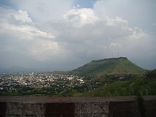
Jawhar is a city and a municipal council in Palghar district of Maharashtra state in Konkan division of India. Jawhar was a capital city of the erstwhile Koli princely state of Jawhar. Situated in the ranges of the Western Ghats, Jawhar is known for its picturesque setting and a vibrant cultural heritage. It is one of the few remaining tribal regions of Maharashtra and is known for its vibrant Warli painting that are a characteristic landmark of this place. Established in 1918, Jawhar is one of the oldest municipal councils in the state of Maharashtra and tourist spot near Mumbai.
Mangalgad, also known as Kangori, is a fort in Maharashtra near the village of Dudhanewadi. Kangori, or Mangalgad Fort, is in the Mahad sub-division about eleven miles (18 km) east by south from Mahad town.

Devgad is a taluka in Sindhudurg district of Maharashtra India consisting of 98 villages. It is located on the Arabian Sea in the coastal Konkan region of Maharashtra, south of Mumbai. Devgad is known globally for its exports of locally grown Alphonso mangoes.
Shirpur is a town and taluka in Dhule district of Nashik Division, Maharashtra. It is located on National Highway 3, which runs from Agra in Uttar Pradesh to Mumbai, Maharashtra. The Arunavati River and Tapi river flows through the city. Shirpur is 50 km from the city of Dhule. It houses Asia's largest and India's first gold refinery. Narsee Monjee Institute of Management Studies has a campus in Shirpur. Ahead of Shirpur there is a small private airport at Village Tande.
Chandgad is a Small city and tehsil headquarters of chandgad taluka, of Kolhapur district that is in the Indian state of Maharashtra.

Maharashtra attracts tourists from other Indian states and foreign countries. It was the second most visited Indian state by foreigners and fourth most visited state by domestic tourists in the country in 2014. Aurangabad is the tourism capital of Maharashtra.
Narayangad is a fort in Pune district near to khodad-Gadachiwadi in the Indian state of Maharashtra.
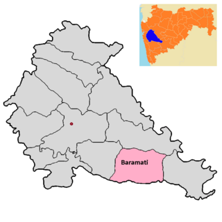
Baramati taluka is a taluka in Baramati subdivision of Pune district of state of Maharashtra in India.

Palghar District is a district in the state of Maharashtra in Konkan Division.
Mangad Fort is a survey fort which is situated in Borwadi, an area near Mashidwadi in Mangaon, a taluka in Raigad district in the Indian state of Maharashtra. The fort is made sacred by the footsteps of the founder of Hindavi Swaraj, the famous Maratha king Chhatrapati Shivaji Maharaja. Mangaon is situated about 150 km from Mumbai.

Bhaskargad fort / Basgad Fort is a fort located 48 km from Igatpuri, Nashik district, of Maharashtra. This fort is one of the fort in Trimbak hill range. This fort is near to the Harihar fort.

Malegaon Fort is land fort located in the busy Malegaon town. It is located 104 km from Nashik, in Nashik district, of Maharashtra. This fort is on the north bank of Mausam river which is a tributary of Girna river and was built during the Maratha Empire.
Hatgad Fort is a fort located 71 km (44 mi)from Nashik, Nashik district, of Maharashtra. The base village is Hatgad on the Nashik-Saputara Road. The nearest town is Saputara, which is 6 km from Hatgad village. It is a historic monument located in Maharashtra, India, south of the hill station of Saputara and near the border with Gujarat. It was built by the Maratha king Shivaji and is located at an elevation of about 3,600 feet. The way to reach the fort is through a trekking route via a narrow rocky path and car also go up to the stairs of fort. A statue of Lord Shivling is placed on the top of the fort.

Gambhirgad Fort is a fort located 58 km from Dahanu, Palghar district, of Maharashtra. This fort is less important fort in Palghar district. The fort is in ruins and restoration is to be done.
Bitangad Fort is a fort in Nashik district in the Igatpuri taluka in Maharashtra state of India.

