The Giant's Causeway (Irish : Clochán an Aifir) [1] is an area of approximately 40,000 interlocking basalt columns, the result of an ancient volcanic fissure eruption. [3] [4] It is located in County Antrim on the north coast of Northern Ireland, about three miles (4.8 km) northeast of the town of Bushmills.
It was declared a World Heritage Site by UNESCO in 1986 and a national nature reserve by the Department of the Environment for Northern Ireland in 1987. In a 2005 poll of Radio Times readers, the Giant's Causeway was named the fourth-greatest natural wonder in the United Kingdom. [5]
The tops of the columns form stepping stones that lead from the cliff foot and disappear under the sea. Most of the columns are hexagonal, although some have four, five, seven, or eight sides. [6] The tallest are approximately 12 metres (39 ft) high, and the solidified lava in the cliffs is 28 metres (92 ft) thick in places.
Much of the Giant's Causeway and Causeway Coast World Heritage Site is owned and managed by the National Trust. It is one of the most popular tourist attractions in Northern Ireland, [7] receiving more than 998,000 visitors in 2019. [8] Access to the Giant's Causeway is free of charge: it is not necessary to go via the visitor centre that charges a fee. [9] The remainder of the site is owned by the Crown Estate and several private landowners.
Around 50 to 60 million years ago, [3] during the Paleocene Epoch, Antrim was subject to intense volcanic activity, when highly fluid molten basalt intruded through chalk beds to form an extensive volcanic plateau. As the lava cooled, contraction occurred. Horizontal contraction fractured in a similar way to drying mud, with the cracks propagating down as the mass cooled, leaving pillarlike structures that also fractured horizontally into "biscuits". In many cases, the horizontal fracture resulted in a bottom face that is convex, while the upper face of the lower segment is concave, producing what are called "ball and socket" joints. The size of the columns was primarily determined by the speed at which lava cooled. [10] The extensive fracture network produced the distinctive columns seen today. The basalts were originally part of a great volcanic plateau called the Thulean Plateau that formed during the Paleocene. [11]
In respect of its key role in the development of volcanology as a geoscience discipline, and notably the origin of basalt, the Palaeocene rocks of the Giant's Causeway and Causeway Coast were included by the International Union of Geological Sciences (IUGS) in its assemblage of 100 "geological heritage sites" around the world in a listing published in October 2022. [12]
According to legend, a form of 'geomyth', the columns are the remains of a causeway built by a giant. The story goes that the Irish giant Fionn mac Cumhaill (Finn MacCool), from the Fenian Cycle of Gaelic mythology, was challenged to a fight by the Scottish giant Benandonner. Fionn accepted the challenge and built the causeway across the North Channel so that the two could meet. In one version of the story, Fionn defeats Benandonner. [13] Another common telling of the story has Fionn hide from Benandonner when he realises that his foe is much bigger than he is. Fionn's wife, Sadhbh, disguises Fionn as a baby and tucks him in a cradle. When Benandonner sees the size of the "baby", he reckons that its father, Fionn, must be a giant among giants. He flees back to Scotland in fright, destroying the causeway behind him so that Fionn would be unable to chase him down. [14] Across the sea, there are identical basalt columns (a part of the same ancient lava flow) at Fingal's Cave on the Scottish isle of Staffa, and it is possible that the story was influenced by this. [15]
Overall, in Irish mythology, Fionn mac Cumhaill is not a giant, but a hero with supernatural abilities, contrary to what this particular legend may suggest. In Fairy and Folk Tales of the Irish Peasantry (1888), it is noted that, over time, "the pagan gods of Ireland [...] grew smaller and smaller in the popular imagination until they turned into the fairies; the pagan heroes grew bigger and bigger until they turned into the giants". [16] There are no surviving pre-Christian stories about the Giant's Causeway, but it may have originally been associated with the Fomorians (Fomhóraigh); [17] the Irish name Clochán na bhFomhóraigh or Clochán na bhFomhórach means "stepping stones of the Fomhóraigh". The Fomhóraigh are a race of mythological beings in Irish mythology who were sometimes described as giants and who may have originally been deities among a pre-Christian pantheon. [18]
Letitia Elizabeth Landon comments on these mythological associations in her notes to The Giant's Causeway ., a poetical illustration to a painting by Thomas Mann Baynes. [19]
William King, Bishop of Derry visited the site in 1692. The existence of the causeway was announced to the wider world the following year by the presentation of a paper to the Royal Society from Sir Richard Bulkeley, a fellow of Trinity College, Dublin. The Giant's Causeway received international attention when Dublin artist Susanna Drury made watercolour paintings of it in 1739; they won Drury the first award presented by the Royal Dublin Society in 1740 and were engraved in 1743. [20] In 1765, an entry on the causeway appeared in volume 12 of the French Encyclopédie , which was informed by the engravings of Drury's work; the engraving of the "East Prospect" appeared in a 1768 volume of plates published for the Encyclopédie. [21] In the caption to the plates, French geologist Nicolas Desmarest suggested, for the first time in print, that such structures were volcanic in origin.
The site first became popular with tourists during the nineteenth century, particularly after the opening of the Giant's Causeway Tramway. Only after the National Trust took over its care in the 1960s were some of the vestiges of commercialism removed. Emperor Pedro II of Brazil, visited the site on 9 July 1877 as part of a largely unpublicised three-day visit to Ireland. [22] [23] [24]
Visitors may walk over the basalt columns that are at the edge of the sea, a half-mile walk from the entrance of the site.[ citation needed ]
The causeway was without a permanent visitor centre between 2000 and 2012, as the previous building, built in 1986, burned down in 2000. [25] While preliminary approval was given for a publicly funded (but privately managed) development by then Environment Minister and Democratic Unionist Party (DUP) member Arlene Foster in 2007, [26] the public funding was frozen due to a perceived conflict of interest between the proposed private developer and the DUP. [27] [28] Ultimately, the private developer dropped a legal challenge to the publicly funded plan, [29] and the new visitor centre was officially opened by 2012. [30] Its construction was funded by the National Trust, the Northern Ireland Tourist Board, the Heritage Lottery Fund and public donations. [31] Since opening, the new visitor centre has garnered mixed reviews from those visiting the causeway, for its pricing, design, contents, and placement across the causeway walk descent. [32] In 2018, the visitor centre was visited by 1,011,473 people. [33]
There was some controversy regarding the content of some exhibits in the visitor centre, which refer to the Young Earth Creationist view of the age of the Earth. [34] [35] While these inclusions were welcomed by the chairman of the Northern Irish evangelical group, the Caleb Foundation, [36] the National Trust stated that the inclusions formed only a small part of the exhibition and that the Trust "fully supports the scientific explanation for the creation of the stones 60 million years ago". [37] An online campaign to remove creationist material was launched in 2012, and following this, the Trust carried out a review and concluded that they should be amended to have the scientific explanation on the origin of the causeway as their primary emphasis. Creationist explanations are still mentioned, but presented as a traditional belief of some religious communities rather than a competing explanation for the origin of the causeway. [38]
Some of the structures in the area, having been subject to several million years of weathering, resemble objects, such as the Organ and Giant's Boot structures. Other features include many reddish, weathered low columns known as Giant's Eyes, created by the displacement of basalt boulders such as the Shepherd's Steps, the Honeycomb, the Giant's Harp, the Chimney Stacks, the Giant's Gate, and the Camel's Hump. [39]
The area is a haven for seabirds, such as fulmar, petrel, cormorant, shag, redshank, guillemot, and razorbill, while the weathered rock formations host numerous plant types, including sea spleenwort, hare's-foot trefoil, vernal squill, sea fescue, and frog orchid. A stromatolite colony was reportedly found at the Giant's Causeway in October 2011 – an unusual find, as stromatolites are more commonly found in warmer waters with higher saline content than that found at the causeway. [40]
Basalt columns are a common volcanic feature. They occur on many scales and with some variations in formation. [41]
The Belfast-Derry railway line run by Northern Ireland Railways connects to Coleraine and along the Coleraine-Portrush branch line to Portrush. Locally, Ulsterbus provides connections to the railway stations. There is a scenic walk of 7 miles (11 km) from Portrush alongside Dunluce Castle and the Giant's Causeway and Bushmills Railway.[ citation needed ]
County Antrim is one of the six counties of Northern Ireland, located within the historic province of Ulster. Adjoined to the north-east shore of Lough Neagh, the county covers an area of 3,086 square kilometres (1,192 sq mi) and has a population of 651,321, as of the 2021 census. County Antrim has a population density of 211 people per square kilometre or 546 people per square mile. It is also one of the thirty-two traditional counties of Ireland.
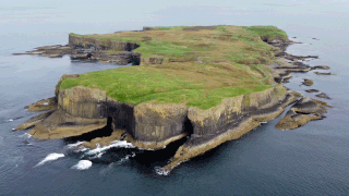
Staffa is an island of the Inner Hebrides in Argyll and Bute, Scotland. The Vikings gave it this name as its columnar basalt reminded them of their houses, which were built from vertically placed tree-logs.
Devils Postpile National Monument is a U.S. National Monument located near Mammoth Mountain in Eastern California. The monument protects Devils Postpile, an unusual rock formation of columnar basalt, "all closely and perfectly fitted together like a vast mosaic." The monument encompasses 798 acres (323 ha) and includes two main attractions: the Devils Postpile formation and Rainbow Falls, a waterfall on the Middle Fork of the San Joaquin River. In addition, the John Muir Trail and Pacific Crest Trail merge into one trail as they pass through the monument. Excluding a small developed area containing the monument headquarters, visitor center and a campground, the National Monument lies within the borders of the Ansel Adams Wilderness.
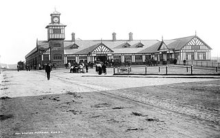
Portrush is a small seaside resort town on the north coast of County Antrim, Northern Ireland. It neighbours the resort of Portstewart in County Londonderry. The main part of the old town, including the railway station as well as most hotels, restaurants and bars, is built on a 1 mile (1.6 km)–long peninsula, Ramore Head. It had a population of 6,150 people at the 2021 census.
Fingal's Cave is a sea cave on the uninhabited island of Staffa, in the Inner Hebrides of Scotland, known for its natural acoustics. The National Trust for Scotland owns the cave as part of a national nature reserve. It became known as Fingal's Cave after the eponymous hero of an epic poem by 18th-century Scots poet-historian James Macpherson.
The Giant's Causeway and Bushmills Railway (GC&BR) is a 3 ft narrow gauge heritage railway operating between the Giant's Causeway and Bushmills on the coast of County Antrim, Northern Ireland. The line is two miles (3.2 km) long.
Royal Portrush Golf Club is a private golf club in County Antrim, Northern Ireland. The 36-hole club has two links courses, the Dunluce Links and the Valley Links. The former is one of the courses on the rota of the Open Championship and last hosted the tournament in 2019.
The Giant's Causeway Tramway, operated by the Giant's Causeway, Portrush and Bush Valley Railway & Tramway Company Ltd, was a pioneering 3 ft narrow gauge electric railway operating between Portrush and the Giant's Causeway on the coast of County Antrim, Northern Ireland. The line, 9+1⁄4 miles (14.9 km) long, was hailed at its opening as "the first long electric tramway in the world". The Giant's Causeway and Bushmills Railway today operates diesel and steam tourist trains over part of the Tramway's former course.
The A2 is a major road in Northern Ireland, a considerable length of which is often referred to the Antrim Coast Road because much of it follows the scenic coastline of County Antrim; other parts of the road follow the coasts in Counties Down and Londonderry.
Trap rock, also known as either trapp or trap, is any dark-colored, fine-grained, non-granitic intrusive or extrusive igneous rock. Types of trap rock include basalt, peridotite, diabase, and gabbro. Trap is also used to refer to flood (plateau) basalts, such as the Deccan Traps and Siberian Traps. The erosion of trap rock created by the stacking of successive lava flows often creates a distinct stairstep landscape from which the term trap was derived from the Swedish word trappa, which means "stairs".
Portballintrae is a small seaside village in County Antrim, Northern Ireland. It is four miles east of Portrush and two miles west of the Giant's Causeway. In the 2011 census, Portballintrae had a population of 601, a decline of 18% compared to 2001. It lies within the Causeway Coast and Glens District Council area.
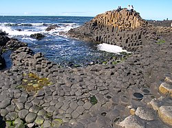
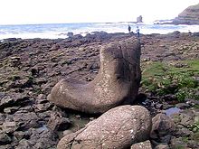
The Giant's Causeway is an area of 40,000 interlocking basalt columns resulting from a volcanic eruption on the coast of Northern Ireland.
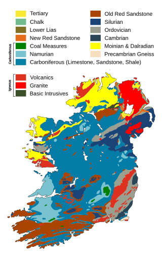
The geology of Ireland consists of the study of the rock formations on the island of Ireland. It includes rocks from every age from Proterozoic to Holocene and a large variety of different rock types is represented. The basalt columns of the Giant's Causeway together with geologically significant sections of the adjacent coast have been declared a World Heritage Site. The geological detail follows the major events in Ireland's past based on the geological timescale.
St. Mary's Islands, also known as Thonsepar, are a set of four small islands in the Arabian Sea, off the coast of Malpe in Udupi, Karnataka, India. They are known for their distinctive geological formation of columnar rhyolitic lava (pictured).
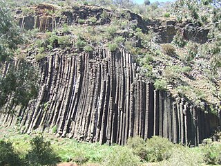
Columnar jointing is a geological structure where sets of intersecting closely spaced fractures, referred to as joints, result in the formation of a regular array of polygonal prisms, or columns. Columnar jointing occurs in many types of igneous rocks and forms as the rock cools and contracts. Columnar jointing can occur in cooling lava flows and ashflow tuffs (ignimbrites), as well as in some shallow intrusions. Columnar jointing also occurs rarely in sedimentary rocks, due to a combination of dissolution and reprecipitation of interstitial minerals by hot, hydrothermal fluids and the expansion and contraction of the rock unit, both resulting from the presence of a nearby magmatic intrusion.
The North Atlantic Igneous Province (NAIP) is a large igneous province in the North Atlantic, centered on Iceland. In the Paleogene, the province formed the Thulean Plateau, a large basaltic lava plain, which extended over at least 1.3 million km2 (500 thousand sq mi) in area and 6.6 million km3 (1.6 million cu mi) in volume. The plateau was broken up during the opening of the North Atlantic Ocean leaving remnants preserved in north Ireland, west Scotland, the Faroe Islands, northwest Iceland, east Greenland, western Norway and many of the islands located in the north eastern portion of the North Atlantic Ocean. The igneous province is the origin of the Giant's Causeway and Fingal's Cave. The province is also known as Brito–Arctic province and the portion of the province in the British Isles is also called the British Tertiary Volcanic Province or British Tertiary Igneous Province.
Causeway Coast and Glens is a local government district covering most of the northern part of Northern Ireland. It was created on 1 April 2015 by merging the Borough of Ballymoney, the Borough of Coleraine, the Borough of Limavady and the District of Moyle. The local authority is Causeway Coast and Glens Borough Council.
The Organ Pipes National Park, abbreviated as OPNP, is a national park located in the Central region of Victoria, Australia. The 121-hectare (300-acre) protected area was established with the focus on conservation of the native flora and fauna, and preservation of the geological features in the Jacksons Creek, a part of the Maribyrnong valley, north-west of Melbourne. It is situated in a deep gorge in the grassy, basalt Keilor Plains.
The Caleb Foundation, created in 1998, is a creationist pressure group in Northern Ireland. It also lobbies on a range of social policy issues such as abortion and same-sex marriage from an evangelical Protestant perspective, and has been particularly influential with Democratic Unionist Party ministers in the Northern Ireland Executive. The organisation has described its mission as "promoting the fundamentals of the historic evangelical Protestant faith".
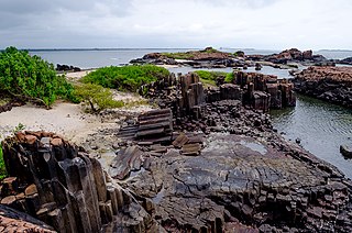
Gành Đá Đĩa or Ghềnh Đá Đĩa is a seashore area of uniformly interlocking basalt rock columns located along the coast in An Ninh Dong Commune, Tuy An District, Phu Yen Province, Vietnam.
Basalt columns are formed when lava that has already solidified cools down [..] The most famous location is certainly Giant's Causeway on the coast of Northern Ireland, but there are also occurrences [in Scotland, Iceland, USA, etc.]