Meteorological history | |
---|---|
Formed | August 3,2024 |
Post-tropical | August 9,2024 |
Dissipated | August 14,2024 |
Category 1 hurricane | |
1-minute sustained (SSHWS/NWS) | |
Highest winds | 80 mph (130 km/h) |
Lowest pressure | 979 mbar (hPa);28.91 inHg |
Overall effects | |
Fatalities | 10 total |
Damage | ≤$2 billion (2024 USD) |
Areas affected |
|
[1] [2] | |
Part of the 2024 Atlantic hurricane season |
Hurricane Debby was a slow-moving and erratic Category 1 hurricane that caused widespread flooding across the Southeastern United States in early August 2024. The fourth named storm and second hurricane of the 2024 Atlantic hurricane season,Debby developed from a tropical wave that was first noted by the National Hurricane Center (NHC) on July 26. After crossing the Greater Antilles,the system began to organize over Cuba and was designated a potential tropical cyclone on August 2. After exiting off the southern coast of Cuba,the disturbance organized into a tropical depression early on August 3. Later that day,it became a tropical storm in the Florida Straits,being named Debby. It moved northwards and gradually intensified into a Category 1 hurricane before making landfall near Steinhatchee,Florida,early on August 5. Debby weakened once inland and began to slow down over the Southeastern United States,causing widespread flooding from heavy rain. It re-emerged in the Atlantic on August 7 before slowly moving northwards again,making landfall in South Carolina early on August 8 before weakening and becoming post-tropical the next day.
States of emergency were declared for the states of Florida,Georgia,North Carolina,South Carolina,and Virginia ahead of the storm. Heavy rains fell as a result of the storm moving slowly,with accumulations peaking near 20 inches (510 mm) of rain near Sarasota,Florida as of August 7. Two dozen tornadoes were confirmed as the storm also moved up the East coast of the United States. Ten fatalities have been attributed to the storm,and preliminary damage reports are estimated to be up to $2 billion.
The National Hurricane Center (NHC) began to monitor a tropical wave over the tropical Atlantic for potential tropical cyclogenesis at 18:00 UTC on July 26, as it moved eastward towards the Lesser Antilles and Greater Antilles. [3] As the disturbance moved westward it crossed over the Virgin Islands, Puerto Rico, [4] and Hispaniola, becoming increasingly defined by August 1. [5] As the system moved over southeastern Cuba, it developed a broad circulation center and disorganized convective bands. Due to the potential threat of the storm to Florida, the NHC designated it as Potential Tropical Cyclone Four at 15:00 UTC on August 2. [6] after that, the disturbance moved off the southern coast of Cuba and formed a closed circulation, allowing the NHC to upgrade and designate it as Tropical Depression Four at 03:00 UTC on August 3. [7] Four entered the Gulf of Mexico where it further intensified into Tropical Storm Debby later on August 3. [8] Debby was a large system with a small core, initially inhibiting its ability to develop rapidly. [9] Despite that, it continued to organize as it traversed the Gulf; though, intruding dry air slightly hindered development. [10] As a result, late on August 4, Debby intensified into a hurricane. [11]
Turning northeastwards slightly in response to a trough in the Northeastern United States, Debby approached the Big Bend area as it peaked with sustained winds of 80 mph (130 km/h) and a minimum pressure of 979 millibars (28.9 inHg) early on August 5. [12] At 11:00 UTC that day, it made landfall in the Big Bend region near Steinhatchee, Florida. [13] Tracking inland, just a few hours later, Debby weakened into a tropical storm. [14] The forward speed of the cyclone began to slow as the aforementioned trough moved off shore and left Debby in light steering currents. [15] Debby moved offshore the coast of Georgia early on August 6 as a weak tropical storm, but eventually strengthened slightly to a secondary peak of 60 mph (97 km/h) as its broad nature prevented much in the way of intensification. Turning slowly northwards again by late on August 7, Debby made landfall again near Bulls Bay, South Carolina, at 05:45 UTC on August 8. [16] Steadily weakening once inland, later that day, Debby weakened into a tropical depression, causing the NHC to pass responsibility for warnings to the Weather Prediction Center (WPC). [17] Early the next day, Debby became a post-tropical cyclone. [18] The remnants of Debby moved into Canada on August 10. [19]
More than 1,000 flights had been canceled due to Debby, including 8% of American Airlines flights. [20]
On July 31, NWS Miami began warning for potential excessive rainfall. [21] The southern Florida Keys and Dry Tortugas were placed under a tropical storm warning. [22] Another tropical storm warning was issued for areas from East Cape Sable to the Suwannee River. [23] Also, from Indian Pass to Mexico Beach, a third tropical storm warning was issued. [24] On the east coast, a tropical storm warning was declared from the Florida-Georgia border to Ponte Vedra Beach. [24] A hurricane warning was declared for areas in between the Suwannee River and Indian Pass. [24] Ahead of Debby's landfall in Florida the SPC issued a Tornado Watch [25] along with a slight 5% tornado risk.
Governor Ron DeSantis declared a state of emergency for 61 counties of Florida. [26] The governor also activated 3,000 members of the Florida National Guard. [27] President Joe Biden approved a disaster declaration for the state August 4. [28] The mayor of Gainesville issued a local state of emergency. [29] Across the state, sandbagging locations opened up. [30] [31] [32] More than 30,000 sandbags were distributed in Tampa. [26] Pinellas County delayed a project to reverse beach erosion. [26] Leon County opened up six shelters. [33] Lake County opened a shelter in an elementary school. [34] In Franklin County, mandatory evacuations were issued for the barrier islands. [35] Citrus County and Levy County also issued mandatory evacuations for their coastal regions. Several other counties issued voluntary evacuations. [36] All state parks in Florida shut down as Debby approached [37] and Carnival Cruise Line's Carnival Elation had its schedule modified. [20]
Coastal Georgia was placed under storm surge and tropical storm warnings. [38] Governor Brian Kemp declared a state of emergency in Georgia ahead of Debby on August 3. [27] [39] Sandbagging sites opened across coastal Georgia. [40] Long County School District delayed their start date to August 8. [41] Savannah-Chatham County Public Schools announced on August 4 that schools would dismiss early on Monday and be closed on Tuesday and Wednesday. [42]
On August 4, Governor Henry McMaster declared a state of emergency in South Carolina as well as state Attorney General Alan Wilson enacting the states price gouging law, which prohibits unfair prices during times of disaster. [43] [44] Marine warnings were issued for waters in the Beaufort and Hilton Head Island areas. [45] At Congaree National Park, where 10–15 in (250–380 mm) of rain was forecast, the park closed at 5pm on August 5, with the earliest possible reopening date being 7am on August 9. All parks in the city of Columbia closed as well. [46] South Carolina suspended some interstate animal transport requirements. [47] Around 50 first responders from Frederick, Howard, and Montgomery counties in Maryland, as well as Washington, D.C., were deployed to Charleston to aid in search and rescue efforts. [48] Charleston implemented a curfew. [49]
Multiple National Weather Service offices in North Carolina issued flood watches for the southeast of the state, [50] and Governor Roy Cooper issued a state of emergency for the entire state. [51] [52]
Parts of Pittsburgh were put under a flood watch on August 9. [53] Hershey Park closed due to the storm on August 9. [54]
Prior to the storm, the National Weather Service issued a wind advisory for New York City, with wind gusts of 50 mph (80 km/h) anticipated on the afternoon of August 9. [55] The MTA installed pumps to alleviate water from the subway systems, to avoid a repeat of recent floods. [56] The New York Racing Association cancelled races scheduled for Friday, August 9 at Saratoga Race Course due to the storm. [57] The New York Yankees postponed their August 9 game against the Texas Rangers due to a forecast of sustained inclement weather. [58]
The precursor to Debby produced thunderstorms over Hispaniola, Puerto Rico, and The Bahamas. [59] The National Weather Service issued flood warnings for 33 municipalities in Puerto Rico, mostly in the eastern half of the island. [60] Debby brought heavy rainfall to western Cuba. Slick roads occurred in Havana, with the heaviest rainfall in the city occurring in Cerro. Rainfall in Artemisa Province peaked at 265 mm (10.4 in) at the Maurín Aqueduct in Bauta. [61]
Amtrak modified the schedules for the Silver Service and Palmetto from August 6-8 and cancelled the August 6 and August 7 runs of the Auto Train due to the storm. [62] Several Piedmont trains were cancelled on August 8-9 as well. [63] Heavy rain, gusty winds and downed trees delayed dozens of trains in Mid-Atlantic and Northeastern United States on August 9. [64]
The outer bands of Debby began impacting Central and South Florida on August 3, bringing gusty winds and rainfall. [65] Several tornado warnings were issued throughout the state, including one for Broward County on August 3. [66] A very brief EF1 tornado occurred in Union County; it overturned a trailer, unroofed a shed, and knocked down a wooden fence and a few trees. [67] Sustained winds neared tropical storm force in Everglades City, though no major damage was reported. [68] More than 2 ft (0.6 m) of storm surge inundated Fort Myers Beach, where communities there were still recovering from the record storm surge from Hurricane Ian nearly 2 years prior, resulting in major flooding. Beach erosion caused road closures in Siesta Key. [69] The city of Sarasota recorded over 20 in (510 mm). [70] As Debby made landfall, almost 250,000 outages were reported. [71] To aid in the response, Duke Energy pulled 350 workers from the Midwest. [72] In Cocoa, Debby flipped five trailers. [73] Two people were killed and another were severely injured in a car accident in Dixie County due to the inclement weather caused by Debby. [74] In Tampa, a 64-year-old trucker died after his semi-truck fell off I-275 into a canal. [75] In Levy County, a 13-year-old boy was killed when a tree fell onto the mobile home he lived in. [76] A 48-year-old man drowned off of Gulfport after his boat partially sunk after he attempted to ride out the storm on it. The man's dog survived. [77] Debby washed ashore 25 packages of cocaine at a beach in the Florida Keys, worth over $1 million, which is believed to have originated from nearby countries in the Caribbean known for drug trafficking. [78] Damage in Manatee County was expected to surpass $13 million based on early estimates. [79] Insured losses for the state is $66.7 million. [80] A submerged car was spotted by a passerby in Phillippi Creek in Southgate on August 12. The Sarasota County Sheriff's Office recovered the vehicle and discovered the body of a 67-year-old man who went missing on August 6 during heavy flooding in the area. [81]
In Georgia, around 47,000 customers lost power. [82] A 19-year-old died in Moultrie after a tree fell on his home. [83] Due to flooding along the Ogeechee River, officials in Effingham County issued a mandatory evacuation for roads along the river. [84]
Seven tornadoes were confirmed in South Carolina; four of them were rated EF1, while three were rated EF0. [85] This included two EF1 tornadoes that impacted Edisto Beach; these tornadoes damaged several homes, some significantly, and snapped or uprooted dozens of trees. [86] [87] In Colleton County, fears developed surrounding a possible breach of the McGrady Dam. The sheriff office declared a mandatory evacuation. Heavy rainfall also caused flooding in parts of Charleston and parts of North Myrtle Beach. [88]
As part of the 2024 United States presidential election, Kamala Harris and her running mate Tim Walz planned to hold a political rally in Raleigh, North Carolina on August 8, as did Republican vice presidential nominee JD Vance; both rallies were postponed due to the hurricane. [89] [90] It was also announced on August 14 that the capital city's southern extension of NC 540 would not be opening to traffic, as planned for August 28th, due to erosion in construction areas. [91] North Carolina governor Roy Cooper deployed around 350 soldiers with 17 water rescue teams to the eastern and central parts of the state. [52] The strongest tornadoes produced by Debby occurred in North Carolina; 10 tornadoes touched down in the state, including three significant (EF2+) tornadoes. An EF2 tornado passed near Harrells, another EF2 tornado caused considerable damage in Greene County, and a low-end EF3 tornado collapsed a home and killed a person near Lucama. Three of the other tornadoes were rated EF1 while the remaining four were rated EF0. [85] [92] [93] [94] One other person was killed in Greensboro. [95]
In Virginia, the storm prompted closures in Shenandoah National Park. [96] Three EF1 tornadoes occurred in the state; they knocked down trees and power poles and damaged numerous structures, including homes. [97] [98] Further north, Washington D.C. recorded 1.18 in (30 mm) of rain in just 30 minutes, with a 2.77 in (70 mm) event total. Winds in DC gusted to 40 mph (64 km/h). [99] A 36-year-old woman died after an oak tree fell onto her home in Shannondale, West Virginia. [100] Another falling tree also damaged a firetruck that responded to the scene along with power lines. [101] [102] An EF0 tornado moved through Hedgesville, West Virginia, uprooting and snapping trees and downing tree branches. [98] Another EF1 tornado occurred northwest of Stanton, Delaware, where a store and a light pole at a strip mall were damaged and trees were snapped or uprooted. [103] In Delaware, rainfall totals on August 8 reached 6.31 in (160 mm), with 1.5 in (38 mm) in West Chester, Pennsylvania and 1.1 in (28 mm) of rain in Philadelphia. This was after heavy rains fell in the region from August 6-7. [104]
Heavy rainfall prompted flash flood emergencies for several towns in Steuben and Allegany counties in New York, where over 4 in (100 mm) of rain fell; those same alerts extended into Westfield, Pennsylvania as well. In addition, multiple impassable roadways were reported in Binghamton, New York. [105] A high-end EF1 tornado struck the eastern part of Harrisburg, Pennsylvania, severely damaging structures and knocking down trees. [106] Another EF0 tornado uprooted trees near New Paltz, New York as well. [85] Significant flooding also occurred in northeast Ohio, as an outer rain band associated with Debby dumped over 7 in (180 mm) of rain in just three hours. [107] [108] This caused the Cuyahoga River to flood and prompted a closure of I-76 near Barberton due to high water. [109]
On Long Island, tropical moisture enhanced by Debby resulted in flooding on August 6, with over 4 in (100 mm) of rain falling down. Three days later, when the actual storm crossed through, winds gusted to 46 mph (74 km/h) in Islip. [110] LaGuardia Airport imposed a ground stop during the storm. [111]
As the remnants of Debby passed through the inner United States on August 10, portions of the New England coastal region faced dangerous rip currents and swells, with the entire coastlines of Maine, Massachusetts, New Hampshire, and Rhode Island being issued a rip current statement by the National Weather Service. [112] A tornado watch was issued in Litchfield County and Hartford County in Connecticut. Multiple trees were downed in Greenwich. Over 9,000 people were left without power in the state. [113] [114] In Vermont, winds of 60 miles per hour (97 km/h) effected the state. In Alburgh, a large tree was knocked down and into a house, with the fire department needing to rescue 3 people. [115] Owners of shops used sandbags and plastic to protect their businesses from the rainfall. Governor Phil Scott placed a Federal Emergency Declaration in the state prior to the arrival of Debby's remnants. [116]
By August 10, over 170,000 people were still left without power across Ohio, Pennsylvania, New York, and Vermont. [117]
The remnants of Debby left rainfall accumulations of 2.0 to 3.9 inches (50 to 100 mm) or more over Eastern Ontario and Southern Quebec, from the Ottawa region to Quebec City and the Côte-Nord region, with maximums of 5.1 to 7.4 inches (130 to 188 mm) in the Montreal and Laval metropolitan area. [118] [119] [120] Mont-Tremblant in the Laurentians received 5.3 inches (134 mm), Trois-Rivières received 4.5 inches (114 mm) and the Charlevoix region received 3.4 inches (87 mm). [120] [121] However, the absolute maximum was recorded at Lanoraie with 8.7 inches (221 mm). [120] Finally, it was the rainiest single day ever measured in Montreal, Quebec, with 6.1 in (154 mm) of rain falling on the city center on August 9. [122] Further west, Ottawa International Airport set a daily rainfall record at 45.5 mm (1.79 in), with up to 83 mm (3.3 in) falling in parts of the city. [123] Numerous basements and highway underpasses were flooded, more than 480,000 Quebec households lost electricity, and festivals were cancelled. [120] [124] Many smaller roads were also washed out. The La Ronde Amusement Park and Granby Zoo were closed due to the heavy rainfall from Debby. [125]
In Mauricie region of Quebec, an 80-year-old fell in a river in Notre-Dame-de-Montauban on August 9. The Sûreté du Québec had to use drones and an helicopter to search along the Batiscan River and found him dead on August 11. [126]
Officials in Steuben County, New York began recovery efforts after Debby had passed. They also announced that they planned to distribute water bottles and clean-up kits to residents impacted by flash flooding on August 11–12. A shelter was opened and operated by the Red Cross at Corning-Painted Post High School for flood victims until August 12 as well. Faith-based disaster relief organizations in Pennsylvania also mobilized to help assess damage and provide help to victims of Debby. [127]
The 1981 Atlantic hurricane season featured direct or indirect impacts from nearly all of its 12 tropical or subtropical storms. Overall, the season was fairly active, with 22 tropical depressions, 12 of which became a namable storm, while 7 of those reached hurricane status and 3 intensified into major hurricanes. The season officially began on June 1, 1981, and lasted until November 30, 1981. These dates conventionally delimit the period of each year when most tropical cyclones form in the Atlantic basin. However, tropical cyclogenesis can occur before these dates, as demonstrated with the development of two tropical depressions in April and Tropical Storm Arlene in May. At least one tropical cyclone formed in each month between April and November, with the final system, Subtropical Storm Three, becoming extratropical on November 17, 1981.
Tropical Storm Bonnie was a tropical storm that made landfall on Florida in August 2004. The second storm of the 2004 Atlantic hurricane season, Bonnie developed from a tropical wave on August 3 to the east of the Lesser Antilles. After moving through the islands, its fast forward motion caused it to dissipate. However, Bonnie later regenerated into a tropical storm near the Yucatán Peninsula. Bonnie attained its peak intensity with maximum 1-minute sustained winds of 65 miles per hour (105 km/h) and a minimum central pressure of 1,001 mbar on August 11 while located over the Gulf of Mexico. Afterwards, the storm turned to the northeast and hit Florida with winds of 45 miles per hour (72 km/h). The storm accelerated to the northeast and became an extratropical cyclone to the east of New Jersey. Bonnie was the first of five tropical systems in the 2004 season to make landfall in Florida, coming ashore the day before Hurricane Charley struck. Bonnie was also the second of a record eight storms to reach tropical storm strength during the month of August.
Tropical Storm Bill was a tropical storm that affected the Gulf Coast of the United States in the summer of 2003. The second storm of the 2003 Atlantic hurricane season, Bill developed from a tropical wave on June 29 to the north of the Yucatán Peninsula. It slowly organized as it moved northward, and reached a peak of 60 miles per hour (97 km/h) shortly before making landfall in south-central Louisiana. Bill quickly weakened over land, and as it accelerated to the northeast, moisture from the storm, combined with cold air from an approaching cold front, produced an outbreak of 34 tornadoes. Bill became extratropical on July 2, and was absorbed by the cold front later that day.
Tropical Storm Beryl caused flooding in several states in the Eastern United States in August 1994. The second named storm and third tropical cyclone of the annual hurricane season, Beryl developed from an upper-level low pressure area over the northeastern Gulf of Mexico on August 14. Initially a tropical depression, the system intensified into a tropical storm about 24 hours after forming. Beryl then moved slowly northeastward and peaked with maximum sustained winds of 60 mph (95 km/h) before making landfall near Panama City, Florida, early on August 16. Within 12 hours of moving inland, the storm weakened to a tropical depression, but persisted as a tropical cyclone for a few days while traversing the Eastern United States. Beryl was absorbed by a frontal system while situated over Connecticut early on August 19.
Tropical Storm Fay was an unusual tropical storm that moved erratically across the state of Florida and the Caribbean Sea. The sixth named storm of the 2008 Atlantic hurricane season, Fay formed from a vigorous tropical wave on August 15 over the Dominican Republic. It passed over the island of Hispaniola, into the Gulf of Gonâve, across the island of Cuba, and made landfall on the Florida Keys late in the afternoon of August 18 before veering into the Gulf of Mexico. It again made landfall near Naples, Florida, in the early hours of August 19 and progressed northeast through the Florida peninsula, emerging into the Atlantic Ocean near Melbourne on August 20. Extensive flooding took place in parts of Florida as a result of its slow movement. On August 21, it made landfall again near New Smyrna Beach, Florida, moving due west across the Panhandle, crossing Gainesville and Panama City, Florida. As it zigzagged from water to land, it became the first storm in recorded history to make landfall in Florida four times. Thirty-six deaths were blamed on Fay. The storm also resulted in one of the most prolific tropical cyclone related tornado outbreaks on record. A total of 81 tornadoes touched down across five states, three of which were rated as EF2. Fay would cause around $560 million in damages throughout its lifespan.
Hurricane Bonnie caused moderate damage along the Gulf Coast of the United States in late June 1986. The second named storm and first hurricane of the 1986 Atlantic hurricane season, Bonnie developed out of an area of low pressure over the central Gulf of Mexico on June 23. The system gradually intensified and was declared Tropical Storm Bonnie the next day as it moved generally towards the west-northwest. On June 25, Bonnie was upgraded to a hurricane. Bonnie strengthened further and on the following day, the storm attained its peak intensity with maximum sustained winds of 85 mph (137 km/h). Shortly thereafter, Bonnie made landfall near High Island, Texas. Following landfall, Bonnie quickly weakened below tropical storm status and dissipated over Missouri on June 28.
The 1994 Atlantic hurricane season was the final season in the most recent negative Atlantic multidecadal oscillation period of tropical cyclone formation within the basin. The season produced seven named tropical cyclones and three hurricanes, a total well below the seasonal average. The season officially started on June 1 and ended on November 30, dates which conventionally limit the period each year when most tropical cyclones tend to form in the Atlantic Ocean. The first tropical cyclone, Tropical Storm Alberto, developed on June 30, while the last storm, Hurricane Gordon, dissipated on November 21. The season was unusual in that it produced no major hurricanes, which are those of Category 3 status or higher on the Saffir–Simpson hurricane scale. The most intense hurricane, Hurricane Florence, peaked as a Category 2 storm with winds of 110 mph (180 km/h).
Hurricane Babe was the second named storm and the first to impact the United States during the inactive 1977 Atlantic hurricane season. Forming out of a tropical wave on September 3, Babe began as a subtropical cyclone in the eastern Gulf of Mexico. The storm gradually intensified as it tracked westward. On September 5, the storm turned north and acquired tropical characteristics. Later that day, Babe intensified into a hurricane and attained its peak strength with winds of 75 mph (120 km/h) and a barometric pressure of 995 mbar. Several hours later, the hurricane made landfall in Louisiana and quickly weakened. By September 6, Babe had weakened to a tropical depression and later dissipated early on September 9 over North Carolina.
Tropical Storm Debby was a tropical cyclone that caused extensive flooding in North Florida and Central Florida during late June 2012. The fourth tropical cyclone and named storm of the 2012 Atlantic hurricane season, Debby developed from a trough of low pressure in the central Gulf of Mexico on June 23. At the time, Debby was the earliest fourth named storm to form within the Atlantic basin on record. Despite a projected track toward landfall in Louisiana or Texas, the storm headed the opposite direction, moving slowly north-northeast and northeastward. The storm slowly strengthened, and at 1800 UTC on June 25, attained its peak intensity with maximum sustained winds of 65 mph (100 km/h). Dry air, westerly wind shear, and upwelling of cold waters prevented further intensification over the next 24 hours. Instead, Debby weakened, and by late on June 26, it was a minimal tropical storm. At 2100 UTC, the storm made landfall near Steinhatchee, Florida with winds of 40 mph (65 km/h). Once inland, the system continued to weaken while crossing Florida, and dissipated shortly after emerging into the Atlantic on June 27.
Tropical Storm Andrea brought flooding to Cuba, the Yucatan Peninsula, and portions of the East Coast of the United States in June 2013. The first tropical cyclone and named storm of the annual hurricane season, Andrea originated from an area of low pressure in the eastern Gulf of Mexico on June 5. Despite strong wind shear and an abundance of dry air, the storm strengthened while initially heading north-northeastward. Later on June 5, it re-curved northeastward and approached the Big Bend region of Florida. Andrea intensified and peaked as a strong tropical storm with winds at 65 mph (105 km/h) on June 6. A few hours later, the storm weakened slightly and made landfall near Steinhatchee, Florida later that day. It began losing tropical characteristics while tracking across Florida and Georgia. Andrea transitioned into an extratropical cyclone over South Carolina on June 7, though the remnants continued to move along the East Coast of the United States, until being absorbed by another extratropical system offshore Maine on June 10.
Tropical Storm Emily was a rapidly-forming tropical cyclone that made landfall on the west coast of Florida. The fifth named storm of the 2017 Atlantic hurricane season, Emily formed from a small area of low pressure that developed along a cold front in late July 2017. Unexpectedly, the low rapidly organized and strengthened into a tropical depression on July 30, and then into a tropical storm early the next day. Emily continued to intensify as it moved eastward, peaking with maximum sustained winds of 60 mph (95 km/h) as it made landfall near Longboat Key on the western Florida coast. The cyclone weakened quickly into a tropical depression shortly after landfall as its circulation became increasingly disrupted. Emerging into the Atlantic Ocean on August 1, Emily continued to weaken as it accelerated northeastward, becoming post-tropical early on August 2.
The 2024 Atlantic hurricane season is the ongoing Atlantic hurricane season in the Northern Hemisphere. The season officially began on June 1, and will end on November 30. These dates, adopted by convention, historically describe the period in each year when most subtropical or tropical cyclogenesis occurs in the Atlantic Ocean. The first system, Tropical Storm Alberto, developed on June 19, making it the latest first named storm since 2014.
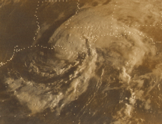
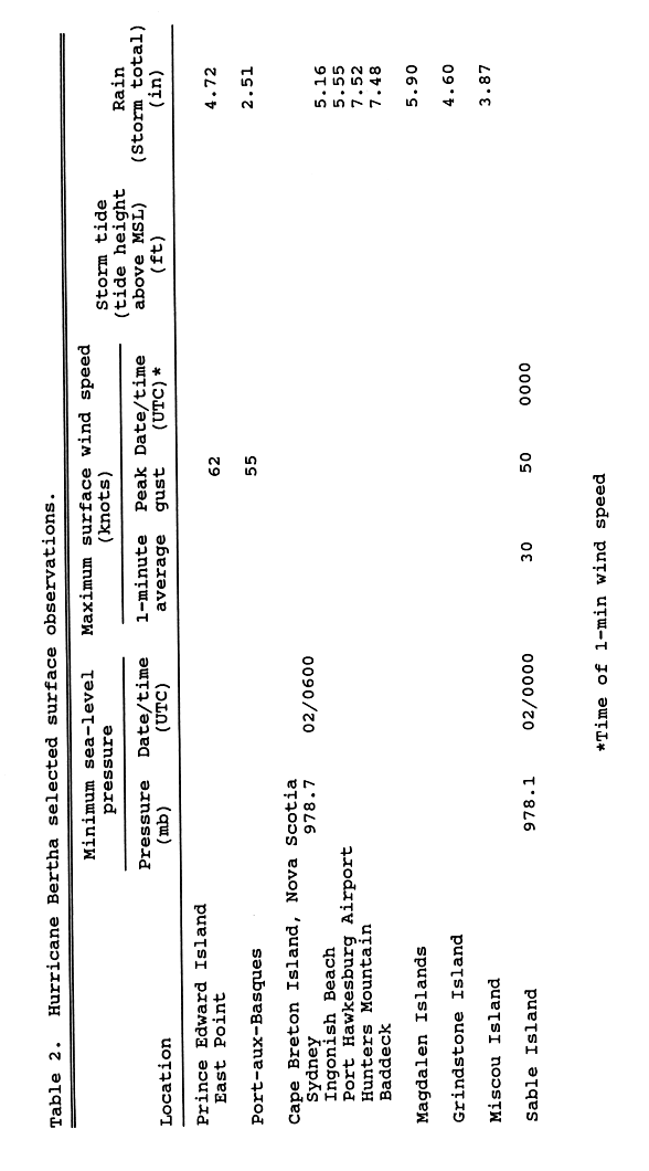
Tropical Storm Bertha was a rapidly forming and short-lived off-season tropical storm that affected the Eastern United States in late May 2020. The second named storm of the very active 2020 Atlantic hurricane season, Bertha originated from a trough in the Gulf of Mexico. The National Hurricane Center (NHC) only anticipated slight development as the trough moved over southern Florida, bringing torrential rainfall. The system rapidly organized on May 27 after it emerged into the western Atlantic Ocean, developing a small, well-defined circulation. That day, the disturbance developed into Tropical Storm Bertha east of Georgia, and a few hours later it moved ashore near Isle of Palms, South Carolina with peak winds of 50 mph (80 km/h). The storm weakened over land and dissipated late on May 28 over West Virginia.
Hurricane Isaias was a destructive Category 1 hurricane that caused extensive damage across the Caribbean and the East Coast of the United States while also spawning the strongest tropical cyclone-spawned tornado since Hurricane Rita in 2005. The ninth named storm and second hurricane of the extremely active and record-breaking 2020 Atlantic hurricane season, Isaias originated from a vigorous tropical wave off the coast of Africa that was first identified by the National Hurricane Center on July 23. The tropical wave gradually became more organized and obtained gale-force winds on July 28 before organizing into Tropical Storm Isaias on July 30. Isaias marked the earliest ninth named storm on record, surpassing 2005's Hurricane Irene by eight days. Isaias strengthened into a Category 1 hurricane on the next day, reaching an initial peak of 85 mph (137 km/h), with a minimum central pressure of 987 mbar. On August 1, the storm made landfall on North Andros, Bahamas and subsequently weakened to a tropical storm, before paralleling the east coast of Florida and Georgia. As Isaias approached the Carolina coastline, it reintensified back into a hurricane. Soon afterward, Isaias reached its peak intensity, with maximum 1-minute sustained winds of 90 mph (140 km/h) and a minimum central pressure of 986 millibars (29.1 inHg), before making landfall near Ocean Isle Beach, North Carolina, at 03:10 UTC on August 4, at the same intensity. The storm proceeded to accelerate up the East Coast of the United States as a strong tropical storm, before transitioning into an extratropical cyclone over Quebec on August 4. Isaias's extratropical remnants persisted for another day, before dissipating on August 5.
Tropical Storm Fred was a strong tropical storm which affected much of the Greater Antilles and the Southeastern United States in August 2021. The sixth tropical storm of the 2021 Atlantic hurricane season, Fred originated from a tropical wave first noted by the National Hurricane Center on August 4. As the wave drifted westward, advisories were initiated on the wave as a potential tropical cyclone by August 9 as it was approaching the Leeward Islands. Entering the Eastern Caribbean Sea after a close pass to Dominica by the next day, the potential tropical cyclone continued northwestward. By August 11, the disturbance had formed into Tropical Storm Fred just south of Puerto Rico, shortly before hitting the Dominican Republic on the island of Hispaniola later that day. The storm proceeded to weaken to a tropical depression over the highly mountainous island, before emerging north of the Windward Passage on August 12. The disorganized tropical depression turned to the west and made a second landfall in Northern Cuba on August 13. After having its circulation continuously disrupted by land interaction and wind shear, the storm degenerated into a tropical wave as it was turning northward near the western tip of Cuba the following day. Continuing north, the remnants of Fred quickly re-organized over the Gulf of Mexico, regenerating into a tropical storm by August 15. Fred continued towards the Florida Panhandle and swiftly intensified to a strong 65 mph (105 km/h) tropical storm before making landfall late on August 16 and moving into the state of Georgia. Afterward, Fred continued moving north-northeastward, before degenerating into an extratropical low on August 18. Fred's remnants later turned eastward, and the storm's remnants dissipated on August 20, near the coast of Massachusetts.