Hurricane Hermine

Last updated

Map key
  Tropical depression (≤38 mph, ≤62 km/h)
  Tropical storm (39–73 mph, 63–118 km/h)
  Category 1 (74–95 mph, 119–153 km/h)
  Category 2 (96–110 mph, 154–177 km/h)
  Category 3 (111–129 mph, 178–208 km/h)
  Category 4 (130–156 mph, 209–251 km/h)
  Category 5 (≥157 mph, ≥252 km/h)
  Unknown
Storm type
Disc Plain black.svg Tropical cyclone
Solid black.svg Subtropical cyclone
ArrowUp.svg Extratropical cyclone, remnant low, tropical disturbance, or monsoon depression

A tropical wave emerged into the Atlantic Ocean from the west coast of Africa between late August 16 and early August 17. [1] On August 18, the National Hurricane Center (NHC) first noted the tropical wave as a potential area for tropical cyclogenesis, associated with an area of disorganized convection about 300 mi (480 km) southwest of Cabo Verde. Environmental conditions were expected to be favorable for continued organization. [2] Dry and stable air was an initial inhibiting factor in development, [3] with deep convection waning on August 20 and August 21. [1] However, the convection and circulation had become better defined by August 21. [4] By August 23, the system had developed an elongated and poorly-defined circulation, as indicated by the Hurricane Hunters, [5] though convention continued to expand. [1] On the next day, the low pressure area crossed Guadeloupe into the Caribbean Sea while producing gale-force winds. [6] [7] By this point, the NHC noted that the system could develop into a tropical depression at any time, as the system was only lacking a well-defined circulation. [8]

Marginal wind shear disrupted the system's organization, and it passed north of Puerto Rico without further development, [9] with winds dropping below gale-force on August 25. [10] Initially, the system moved quickly westward with a forward speed averaging about 23 mph (37 km/h), but slowed down considerably after the northern portion of the wave split off on August 26. [1] The low pressure area crossed the southern Bahamas with scattered convection, [11] becoming more defined on August 27 while moving near the northern Cuban coast. [12] Wind shear prevented quicker development, [13] although conditions became more favorable closer to the Gulf of Mexico. On August 28, the convection increased and became more organized. [14] Later that day, the Hurricane Hunters observed a well-defined circulation. [15] Based on the observations and the convective organization, it is estimated that Tropical Depression Nine developed at 18:00  UTC on August 28 while situated about 60 mi (100 km) south-southeast of Key West, Florida. [1]

A rainstorm on the edge of Hermine, shortly after the hurricane achieved Category 1 status. Hurricane Hermine Storm Orlando Intl.jpg
A rainstorm on the edge of Hermine, shortly after the hurricane achieved Category 1 status.

Deep convection increased further as the depression moved more into the Gulf of Mexico, [16] steered by a ridge over southern Florida, [17] although it remained ragged and displaced from the circulation. [18] Dry air to the system's west negated the otherwise favorable warm waters. [17] The depression failed to organize more on August 30 as the low- and mid-level circulations remained misaligned. [19] A large plume of convection developed over the system on August 31 as outflow improved and wind shear decreased. [20] Later that day, reports from the Hurricane Hunters indicated that the depression intensified into Tropical Storm Hermine about 395 mi (640 km) southwest of Apalachicola, Florida. [21] Late on August 31, Hermine began accelerating to the northeast, influenced by a developing mid-level trough over the southeastern United States. [22] Lessening shear and water temperatures around 86 °F (30 °C) allowed the storm to intensify. [23] Although outflow was restricted to the northwest, curved rainbands increased over the eastern half of the system, [24] increasing the extent of tropical storm-force winds. [25] Additionally, a ragged eye became visible on satellite imagery on September 1, and at 18:00 UTC, Hermine intensified into a Category 1 hurricane on the Saffir–Simpson scale. [1]

Visualization depicting Post-Tropical Cyclone Hermine, as observed by the GPM Core Satellite on September 6

The hurricane strengthened slightly further to a peak intensity of 80 mph (130 km/h) by 00:00 UTC on September 2. [26] At around 05:30 UTC (1:30 a.m. EDT) that day, Hermine made landfall just east of St. Marks, Florida, at peak intensity, with a minimum pressure of 981 mbar (hPa; 29.00 inHg). [1] Hermine became the first hurricane to make landfall in Florida since Wilma on October 24, 2005. [27] Within four hours of landfall, the winds dropped below hurricane force as the appearance on radar imagery degraded. [28] The convection diminished while Hermine crossed into Georgia, with the strongest winds near the Atlantic coast. [29] The center elongated as it continued quickly northeastward ahead of the trough. [30] With the convection far ahead of the circulation, Hermine transitioned into an extratropical cyclone at 12:00 UTC on September 3 as it emerged into the Atlantic Ocean from the Outer Banks of North Carolina. [1] Dry air wrapped into the eastward-moving center, [31] while convection pulsed north of the former hurricane, possibly due to the warmer waters of the Gulf Stream. [32] By September 5, the system devolved into several rotating circulations as the overall system slowed and turned to the northwest, steered by a ridge to the north. [33] The convection began waning on the next day, [34] as the storm turned due westward. [35] At 18:00 UTC on September 6, the NHC ceased issuing advisories on the post-tropical cyclone as Hermine continued to weaken amid cooler waters and convective stability. [36] The remnants continued to meander offshore New Jersey and Long Island, eventually dissipating near Chatham, Massachusetts late on September 8. [1]

Preparations

Workers preparing sandbags ahead of Hermine in North Charleston, South Carolina Sandbags ahead of Hermine (29281335322).jpg
Workers preparing sandbags ahead of Hermine in North Charleston, South Carolina

On August 30, the NHC began issuing tropical cyclone warnings and watches for the Florida Gulf Coast. By the time Hermine reached hurricane status, a hurricane warning was in place from the mouth of the Suwannee River to Mexico Beach. A tropical storm warning extended southward to Englewood, which included the Tampa Bay Area, and westward to the WaltonBay county line. A hurricane watch was also in effect from the mouths of the Suwannee and Anclote rivers. On August 31, a tropical storm watch was added for the Atlantic coast between Marineland, Florida, to the Altamaha Sound in Georgia. As Hermine approached and moved up the coast, tropical storm warnings were in place as far south as Marineland, and as far northeast as Sagamore Beach, Massachusetts, including portions of the Tidal Potomac River, the Chesapeake and Delaware bays, Long Island Sound, New York City, Block Island, Martha's Vineyard, Nantucket, and Cape Cod. All tropical storm warnings were dropped when the NHC discontinued advisories at 18:00 UTC on September 6. [1]

Florida Governor Rick Scott declared a state of emergency for 51  counties. [37] In response to the then-developing storm, early voting for the primary election on August 30 was extended by one day in Bradford, Broward, Charlotte, Duval, Hillsborough, Miami-Dade, Orange, Osceola, Palm Beach. and Pinellas counties. [38] In six counties, school was canceled on September 1 and 2, while twenty-nine other counties had no school on September 2. [37] [39] Mandatory evacuations were ordered for portions of Dixie, Franklin, Taylor, and Wakulla counties. [37]

States of emergencies were declared in Georgia, [27] North Carolina, Virginia, Maryland, and New Jersey due to the storm. [40] Hermine affected the east coast of the United States during the busy Labor Day weekend, causing many beaches to be closed in Delaware, New Jersey, and New York. [40] Amtrak canceled or altered train lines due to the threat from the storm. [27] In Savannah, Georgia, Bacon Fest was cancelled, and a beer fest was moved indoors. [41] In Charleston, South Carolina, the city government provided 3,000 sandbags to residents, preparing less than a year after damaging floods hit the state. Outer Banks ferry service was cancelled [42] and bridges in Dare County, North Carolina, were closed due to the high winds. Officials deployed or readied swift water teams, helicopters, and the North Carolina National Guard in the eastern portion of the state. The Virginia National Guard utilized 270 members to help prepare for the storm's potential flooding and power outages. [42] A Bruce Springsteen concert in Virginia Beach, Virginia, was postponed two days, [40] and several performances for the town's American Music Festival were cancelled or moved indoors. [43]

Impact

Caribbean

On Antigua, a lightning strike produced by thunderstorms associated with the precursor tropical wave severely damaged two 69 kV transmission lines, causing an island-wide blackout on August 24. [44] Some locations in Puerto Rico observed 3 to 5 in (76 to 127 mm) of rainfall, [45] causing flooding, especially in the Ponce area. Primarily, streets were inundated with water, though at least one house was flooded. [46] In the Dominican Republic, some areas received nearly 4 in (100 mm) of rain on August 25 alone from Hermine's precursor. In 19 provinces, residents and authorities were on alert due to rapidly rising rivers and expectations of flooding. [47] Throughout the country, the storm damaged more than 200 homes and displaced over 1,000 people. [48]

While in its developmental stages, the precursor low dropped 3 to 5 in (76 to 127 mm) of rainfall across northern Cuba. [12] Candelaria in western Cuba recorded 12.24 in (310.8 mm). [49] At Cienfuegos, 4.25 in (108 mm) of precipitation fell in only three hours. [1] The rains alleviated drought conditions and helped replenish reservoirs, while also causing landslides. [49] The Zaza Reservoir – the largest in Cuba – increased its total water volume by 495,000,000 cubic feet (14,000,000 m3), bringing the levels to 30% capacity. In Batabanó on Cuba's southern coast, 8.5 in (215 mm) of rainfall caused moderate flooding. [50] Near Havana, the electric company shut off power to prevent accidents, while damage occurred to gas lines. [49]

United States

Total economic losses across the United States reached US$550 million. [1] [51] Insured losses to property in Florida reached US$80 million with 14,890 claims. [52]

Florida

Infrared satellite loop of Hermine making landfall in Florida on September 2 Hermine AVN landfall grid.gif
Infrared satellite loop of Hermine making landfall in Florida on September 2

Ahead of the hurricane's landfall, a station south of Apalachicola reported wind gusts of 79 mph (127 km/h) at an elevation of 115 ft (35 m). [53] At sea level, sustained winds reached 52 mph (84 km/h) at Keaton Beach, with gusts 67 mph (108 km/h). [54] While moving ashore, Hermine produced a 5.8 ft (1.8 m) storm surge at Cedar Key. [55] Heavy rainfall occurred across western Florida, reaching 22.36 in (568 mm) over 72 hours at the Lake Tarpon Canal in Pinellas County. [56] The outer rainbands of Hermine spawned an EF0 tornado just southwest of Windermere with a width of 450 ft (140 m) and 80 to 85 mph (129 to 137 km/h) winds. On the ground for 1.2 mi (1.9 km), the twister damaged about 100 trees, along with several fences and windows. [57] The storm spawned three other EF0 tornadoes, all in Taylor County, none of which caused damage. [58]

High winds from the hurricane knocked down many trees in northwestern Florida, some of which fell onto power lines and roofs. The resulting power outages affected about 325,000 people, [27] roughly 1% of all homes and businesses in the state. [42] In Leon County, where the state capital Tallahassee is, 57% of homes lost power, [42] including approximately 80% of the city proper, as well as Florida State University. [27] Of the 145,000 homes and businesses that lost electricity, 3,685 were still without power six days after the storm. [58] Strong winds in the Tallahassee area caused trees to fall onto several houses, injuring a number of people. [27] Hermine was the first hurricane to directly affect the city since Hurricane Kate in 1985. [42] Throughout Leon County, 45 homes or businesses were destroyed, 187 suffered severe damage, and 259 experienced minor damage. [58] Losses across Leon County reached $10.3 million. [59]

Radar image of Hurricane Hermine about 40 minutes after landfall Hurricane Hermine radar 0608UTC 02Sept2016.png
Radar image of Hurricane Hermine about 40 minutes after landfall

Storm surge and abnormally high tides caused significant damage along the Gulf Coast of Florida. In Franklin County, coastal flooding occurred in Alligator Point, Apalachicola, and Carrabelle. A total of 27 homes or businesses were demolished, 43 suffered major damage, and 102 others sustained minor damage. [58] Winds in Wakulla County downed a number of trees, with 133 falling on roadways and 7 falling on homes. [58] [27] A total of 115 power lines were downed, with about 14,759 customers losing electricity. [58] The Gulf Specimen Marine Laboratory in Panacea suffered extensive damage, especially to their educational Living Dock. [60] The Wakulla River at Wakulla Springs reached its second highest level recorded, behind only Hurricane Dennis in 2005. One business was destroyed and four homes sustained severe damage, while an additional forty-three dwellings experienced minor damage. [58] In Jefferson County, much of the impact consisted of downed trees and power lines. [61] About 62% of residents were left without electricity. [62] Strong winds in Madison County left similar impact, but little structural damage. However, the Madison Creative Arts School suffered severe roof damage, while a mansion was damaged by a large falling tree. [63] Twelve people were rescued in Taylor County due to storm surge, [64] including six in Steinhatchee. Throughout the county, approximately 75 homes or businesses were inflicted major damage, while 60 suffered minor impact. [58] At Dekle Beach, the storm damaged several buildings and wrecked a 300 ft (91 m) fishing pier. [27]

In Dixie County, storm surge heights generally ranged from 8 to 9 ft (2.4 to 2.7 m) and peaked just inches below observations during the 1993 Storm of the Century. A total of 61 homes or businesses that were demolished, 540 sustained major damage, and 322 suffered minor impact. [58] Much of the damage in Levy County was also due to storm surge, with 6 to 8 ft (1.8 to 2.4 m) above average tides observed. [58] In Cedar Key, storm surge washed across the entire island. The only grocery store suffered wind and coastal flood damage, with food scattered on the floor. At a motel, water swept away air conditioners and left seaweed and mud inside. The storm caused an electrical fire that burnt down the clam processing plant. On Dock Street, which contains several restaurants on stilts, the decks and interiors of the restaurants were damaged. [65] The post office and city hall were severely damaged. [66] Storm damage in Cedar Key was estimated at over $10 million. [65] Additionally, over 40 homes and businesses in west Yankeetown were damaged by coastal flooding. Throughout Levy County, one structure was destroyed, 68 suffered major damage, and 51 others received minor impact. [58] Coastal areas of Citrus County suffered from significant flooding; 2,694 structures sustained damage, of which 531 suffered major damage. Total losses in the county reached $102 million. [67]

Damage to a church in Tallahassee, Florida Herminetallychurch.png
Damage to a church in Tallahassee, Florida

In Hernando County, the storm destroyed two houses and severely damaged 18 more, with 179 sustaining minor damage; the county damage toll was estimated at $7.8 million. [68] Heavy rainfall in the Tampa Bay Area flooded streets, causing cars to stall, and forced people to evacuate their homes. [55] Power outages affected the local wastewater treatment plant, causing 938,000 US gallons (3,550,000 L) of partially treated sewage to flow into Hillsborough Bay. [69] In Pasco County, 18 people required rescue from high-water vehicles and were transported to nearby shelters. [27] Property damage totaled $111 million, [70] making Hermine one of the costliest storms on record in the county. Of the 2,672 households affected, 7 were destroyed, 305 sustained major damage, and 1,564 sustained minor damage. [71] [72] Damage incurred by roads was estimated at $30–50 million. [73] Much of the impact in Hillsborough County was caused by wind, with a gust up to 58 mph (93 km/h) observed at Port Tampa. Throughout the county, 8 homes sustained minor damage, 7 dwellings experienced major damage, and 9 homes were destroyed. Damage was estimated at $800,000. [74] In Hillsborough and Pinellas counties, about 39,000 people lost electricity. [58]

Numerous trees were uprooted or snapped in Alachua County, with several damaging homes in Gainesville. A number of power lines were also downed. In Marion County, trees were reported downed in several areas. A falling tree damaged a house, while another fell on a road and was later hit by a car, causing two people to be hospitalized. [75] Additionally, a homeless man camping near Ocala was killed when a tree fell on his tent. [74] In Lake County, wind gusts estimated at 58 mph (93 km/h) downed trees and power lines in several cities, including Clermont, Eustis, Groveland, Mascotte, Mount Dora, and Tavares. [58]

In Manatee County, precipitation totals generally ranged from 5 to 10 in (130 to 250 mm), inundating streets in the eastern parts of the county. Residents in Bradenton, located in the western side of the county, evacuated their homes due to freshwater flooding. [58] Coastal flooding also occurred due to tides of 2–3 ft (0.61–0.91 m) above average. Winds reached tropical storm force at the Sarasota–Bradenton International Airport, with damage to roofs and porches, especially in Brandenton and Ellenton. Throughout the county, impacts from the storm left 72 homes with minor damage and 21 others with major impact. Damage in Manatee County reached $5.1 million. Heavy rain fell across Sarasota County, ranging from 4 to 7 in (100 to 180 mm) during the three day period. Widespread street flooding occurred in the eastern portions of the county, while some residents in Sarasota evacuated their homes. Damage caused by flooding reached about $250,000. Along the coast, tides 2 to 3 ft (0.61 to 0.91 m) above normal left major or moderate damage to 34 homes and minor impact to another. Additionally, beach erosion damage occurred at Lido Beach and Turtle Beach. Coastal flooding damage in Sarasota County reached about $4.75 million. In Collier County, coastal flooding left docks and low-lying streets under water, including State Road 92 near Goodland Bay. Everglades Airpark in Everglades City was closed after high water reached the runway. [58]

Elsewhere

A tree fallen on a house in Valdosta, Georgia Tree on house, Hurricane Hermine, Valdosta, Georgia.jpg
A tree fallen on a house in Valdosta, Georgia
Hurricane Hermine wind history as a tropical cyclone Hurricane Hermine wind history as a tropical cyclone.gif
Hurricane Hermine wind history as a tropical cyclone

Hermine weakened while crossing from Florida into Georgia, but still produced sustained winds of 45 mph (72 km/h) at Savannah, with gusts to 58 mph (93 km/h). [76] Farther northeast, Folly Island, South Carolina, reported sustained winds of 44 mph (71 km/h) with gusts to 59 mph (95 km/h), [77] and the pier in Duck, North Carolina, reported sustained winds of 58 mph (93 km/h) with gusts to 73 mph (117 km/h). [78] Heavy rainfall occurred through the Carolinas, reaching 10.72 in (272 mm) in Murrells Inlet, South Carolina. [79] At Norfolk International Airport, wind gusts reached 43 mph (69 km/h). [80] In Georgia, South Carolina, North Carolina, and Virginia, Hermine's passage left around 274,000 people without power. [40] [42] [81] [82]

In Georgia, Hermine's winds knocked down trees onto cars and homes, resulting in several injuries in the subsequent cleanup process, although there was no major damage. [42] The storm spawned two EF1 tornadoes in the state. The first, with a 4.83 mi (7.77 km) path, knocked down or broke thousands of trees in Liberty County, some of which fell onto homes. The other struck Skidaway Island and downed hundreds of trees, causing damage to 20 roofs. [83] On St. Simons Island, the storm sank up to five boats at the Morning Star Marina. [75] In southwestern Georgia, impact in several counties was limited to down trees and power lines, including in Berrien, Colquitt, Cook, Dougherty, Grady, Tift, Thomas, Lanier, Mitchell, and Worth counties. [58] A pecan farm near Ray City, located in Berrien County, suffered roughly US$4 million in damage as winds of 40 to 55 mph (64 to 89 km/h) felled about 1,000 trees and ruined 1 million pounds of fruit. [84] In Grady County, about 2,800 customers lost electricity. The storm left power outages in Colquitt County, where a tree fell on a house. Winds in Dougherty County downed tree limbs that damage two roofs, while 200 electrical service losses occurred. In Tift County, trees and power lines were downed on many roadways, including Route 41 and Route 125. [58]

It was estimated that Lowndes County experienced sustained winds near 65 mph (105 km/h). [85] The storm downed a number of trees and power lines, with hundreds falling in Valdosta, resulting in the closure of about 90 roads throughout Lowndes County. [58] Some of the trees also fell on houses. [85] Another road was closed after a box culvert washed out. [86] A bridge along Old Quitman Road was damaged and required repairs. [87] Additionally, about 31,000 customers were left without electricity. The winds downed approximately 1,000 pecans trees, leaving about $3 million in damage to the pecan crop. Property damage totaled around $1 million. Sewer systems were overwhelmed by heavy rainfall, causing up a sewage spillage of up to 117,000 gallons. [58]

Post-Tropical Cyclone Hermine southeast of New England on September 5 Hermine 2016-09-05 1407Z.jpg
Post-Tropical Cyclone Hermine southeast of New England on September 5

The storm flooded roads and downed trees in South Carolina, mostly in Beaufort, Bluffton, and Hilton Head Island. [42] At Hilton Head Island, falling trees severely damaged 13 homes, one of which just over two weeks after a tree had fallen in the same manner upon the same house. Damage to the dwellings reached about $250,000. Falling trees damaged at least two homes in Edisto Beach, while strong winds deroofed and ripped sidings off several other residences. In Cottageville, a man was killed after being hit by a car while he was removing a fallen tree from the highway. [88] In the Charleston area, the airport observed a daily rainfall record of 2.32 in (59 mm) on September 2. A number of roads were flooded in downtown Charleston and North Charleston. In Dorchester County, high winds downed a number of trees, some of which caused roads to be closed. A tree also struck a liquid oxygen tank at the medical center in Summerville, causing a leak that forced the closure of all entrances to the complex. Nearly 7,000 people in the county were left without electricity at the height of the storm. [89]

Strong winds in eastern North Carolina resulted in sporadic power outages. Hermine spawned two EF1 tornadoes and one EF0 tornado over Outer Banks. [58] One knocking over two trailers and injuring four people. [90] The tornadoes collectively left about $30,000 in damage. [58] High winds knocked over an 18-wheeler tractor-trailer crossing the Alligator River bridge on U.S. Route 64, killing the driver. [40] [41] Flooding covered portions of Highway 12, the main roadway through the Outer Banks. [42] Bands of heavy rain associated with Hermine produced rainfall totals of 4 to 8 in (100 to 200 mm) over most of the region, with the highest amounts near the coast. Widespread poor drainage flooding occurred, with a few reports of flash flooding. Damage across Dare County reached $5.5 million; [58] most of the damage was concentrated on Hatteras Island with flooding in Frisco and Hatteras. [91]

In Virginia, abnormally high tides resulted in coastal flooding, particularly in the Norfolk area. A number of low-lying and flood prone neighborhoods were inundated, while Willoughby Spit became impassable. Cars parked at Hague Tower apartments were submerged up to their windows. In Virginia Beach, winds downed signs and branches and ripped siding from a hotel. At another hotel, some rooms suffered roof leaks. [92] On eastern Long Island, two fishermen drowned after being swept into the ocean near the Wading River due to rough surf. [93] Their bodies were later recovered in Shoreham. [94] Nantucket offshore Massachusetts recorded sustained winds of 39 mph (63 km/h) on September 5, with gusts to 52 mph (84 km/h). [95] Royal Caribbean's Anthem of the Seas encountered 40 ft (12 m) seas and 112 mph (180 km/h) winds on its trek from New Jersey to Bermuda, leaving several passengers seasick. [96] In Connecticut, Massachusetts, and Rhode Island, minor wind damage occurred because trees were still fully leaved in those states. Coastal flooding was limited due to storm surge peaking at low tide. [58]

Aftermath

After Hermine exited the state, Florida governor Rick Scott took an aerial tour of the damage in Cedar Key and Steinhatchee, pledging that affected businesses would receive assistance from the state government. [42] On September 20, Governor Scott submitted a request to the federal government for individual disaster assistance in 12 counties and public assistance in 15 counties. United States president Barack Obama issued a disaster declaration on September 28. Residents and households in Citrus, Dixie, Hernando, Hillsborough, Leon, Levy, Pasco, and Pinellas counties became eligible for aid. In Citrus, Dixie, Franklin, Jefferson, Lafayette, Leon, Levy, Liberty, Madison, Pasco, Pinellas, Suwannee, Taylor, and Wakulla counties, money was allotted to state and local governments as well as some private, nonprofit organizations on a cost-sharing basis; this fund allowed for emergency work on or replacement of buildings damaged by the storm. Additionally, the state of Florida received money from the Hazard Mitigation Grant Program for hazard mitigation. [97] However, the disaster declaration was eventually expanded to several other counties. By November 2, Alachua, Baker, Columbia, Gadsden, Gilchrist, Manatee, Marion, Sarasota, Sumter, and Union counties were eligible for public assistance or both public and individual assistance. [98]

In addition to federal aid, the Federal Emergency Management Agency (FEMA) opened five disaster recovery centers, with one in Citrus County, one in Dixie County, one in Leon County, and two in Levy County. These disaster centers were staffed by representatives of FEMA, the Florida Division of Emergency Management, the Small Business Administration, and other state agencies. FEMA agents also went door-to-door in Tallahassee to ask residents about damage to their property. [99]

In Lee County, crews were deployed to collect plant debris. [100] Due to storm damage, officials in Hernando County provided curbside debris removal, and two parks were closed. [101] The post office in Cedar Key was damaged severely enough to remain closed for repairs until February, [102] while the city hall has yet[ as of? ] to reopen. In the meantime, city business has been conducted in a double-wide trailer near the city hall. [103] In Franklin County, the St. George Island Bridge was reopened just 15 hours after its closure to allow access to cleanup crews. [104]

See also

Related Research Articles

<span class="mw-page-title-main">1995 Atlantic hurricane season</span> Hurricane season in the Atlantic Ocean

The 1995 Atlantic hurricane season was a very active Atlantic hurricane season, and is considered to be the start of an ongoing era of high-activity tropical cyclone formation. The season produced twenty-one tropical cyclones, nineteen named storms, as well as eleven hurricanes and five major hurricanes. The season officially began on June 1 and ended on November 30, dates which conventionally delimit the period of each year when most tropical cyclones develop in the Atlantic basin. The first tropical cyclone, Hurricane Allison, developed on June 2, while the season's final storm, Hurricane Tanya, transitioned into an extratropical cyclone on November 1. The very active Atlantic hurricane activity in 1995 was caused by La Niña conditions, which also influenced an inactive Pacific hurricane season. It was tied with 1887 Atlantic hurricane season with 19 named storms. And was later in 2010, 2011, and 2012 seasons respectively.

<span class="mw-page-title-main">2004 Atlantic hurricane season</span> Hurricane season in the Atlantic Ocean

The 2004 Atlantic hurricane season was a very deadly, destructive, and active Atlantic hurricane season, with over 3,200 deaths and more than $61 billion in damage. More than half of the 16 tropical cyclones brushed or struck the United States. Due to the development of a Modoki El Niño – a rare type of El Niño in which unfavorable conditions are produced over the eastern Pacific instead of the Atlantic basin due to warmer sea surface temperatures farther west along the equatorial Pacific – activity was above average. The season officially began on June 1 and ended on November 30, though the season's last storm, Otto, dissipated on December 3, extending the season beyond its traditional boundaries. The first storm, Alex, developed offshore of the Southeastern United States on July 31, one of the latest dates on record to see the formation of the first system in an Atlantic hurricane season. It brushed the Carolinas and the Mid-Atlantic, causing one death and $7.5 million (2004 USD) in damage. Several storms caused only minor damage, including tropical storms Bonnie, Earl, Hermine, and Matthew. In addition, hurricanes Danielle, Karl, and Lisa, Tropical Depression Ten, Subtropical Storm Nicole and Tropical Storm Otto had no effect on land while tropical cyclones. The season was the first to exceed 200 units in accumulated cyclone energy (ACE) since 1995, mostly from Hurricane Ivan, the storm produced the highest ACE. Ivan generated the second-highest ACE in the Atlantic, only behind 1899 San Ciriaco Hurricane.

<span class="mw-page-title-main">1999 Atlantic hurricane season</span> Hurricane season in the Atlantic Ocean

The 1999 Atlantic hurricane season was a fairly active season, mostly due to a persistent La Niña that developed in the latter half of 1998. It had five Category 4 hurricanes – the highest number recorded in a single season in the Atlantic basin, previously tied in 1933 and 1961, and later tied in 2005 and 2020. The season officially began on June 1, and ended on November 30. These dates conventionally delimit the period of each year when most tropical cyclones form in the Atlantic basin. The first storm, Arlene, formed on June 11 to the southeast of Bermuda. It meandered slowly for a week and caused no impact on land. Other tropical cyclones that did not affect land were Hurricane Cindy, Tropical Storm Emily, and Tropical Depression Twelve. Localized or otherwise minor damage occurred from Hurricanes Bret, Gert, and Jose, and tropical storms Harvey and Katrina.

<span class="mw-page-title-main">1998 Atlantic hurricane season</span> Hurricane season in the Atlantic Ocean

The 1998 Atlantic hurricane season was a catastrophic and deadly Atlantic hurricane season, featuring the highest number of storm-related fatalities in over 218 years and some of the costliest ever at the time. The season had above average activity, due to the dissipation of an El Niño event and transition to La Niña conditions. It officially began on June 1 and ended on November 30, dates which conventionally delimit the period during which most tropical cyclones form in the Atlantic Ocean. The season had a rather slow start, with no tropical cyclones forming in June. The first tropical cyclone, Tropical Storm Alex, developed on July 27, and the season's final storm, Hurricane Nicole, became extratropical on December 1.

<span class="mw-page-title-main">1992 Atlantic hurricane season</span> Hurricane season in the Atlantic Ocean

The 1992 Atlantic hurricane season was a significantly below average season for overall tropical or subtropical cyclones as only ten formed. Six of them became named tropical storms, and four of those became hurricanes; one hurricane became a major hurricane. The season was also near-average in terms of accumulated cyclone energy. The season officially started on June 1 and officially ended on November 30. However, tropical cyclogenesis is possible at any time of the year, as demonstrated by formation in April of an unnamed subtropical storm in the central Atlantic.

<span class="mw-page-title-main">Tropical Storm Helene (2000)</span> Atlantic tropical storm in 2000

Tropical Storm Helene was a long-lived tropical cyclone that oscillated for ten days between a tropical wave and a 70 mph (110 km/h) tropical storm. It was the twelfth tropical cyclone and eighth tropical storm of the 2000 Atlantic hurricane season, forming on September 15 east of the Windward Islands. After degenerating into a tropical wave, the system produced flooding and mudslides in Puerto Rico. It reformed into a tropical depression on September 19 south of Cuba, and crossed the western portion of the island the next day while on the verge of dissipation. However, it intensified into a tropical storm in the Gulf of Mexico, reaching its peak intensity while approaching the northern Gulf Coast.

<span class="mw-page-title-main">Tropical Storm Edouard (2002)</span> Atlantic tropical cyclone

Tropical Storm Edouard was the first of eight named storms to form in September 2002, the most such storms in the North Atlantic for any month at the time. The fifth tropical storm of the 2002 Atlantic hurricane season, Edouard developed into a tropical cyclone on September 1 from an area of atmospheric convection associated with a cold front east of Florida. Under weak steering currents, Edouard drifted to the north and executed a clockwise loop to the west. Despite moderate to strong levels of wind shear, the storm reached a peak intensity of 65 mph (105 km/h) on September 3, but quickly weakened as it tracked westward. Edouard made landfall on northeastern Florida on September 5, and after crossing the state it dissipated on September 6 while becoming absorbed into the larger circulation of Tropical Storm Fay.

<span class="mw-page-title-main">Tropical Storm Hermine (1998)</span> Atlantic tropical cyclone

Tropical Storm Hermine was the eighth tropical cyclone and named storm of the 1998 Atlantic hurricane season. Hermine developed from a tropical wave that emerged from the west coast of Africa on September 5. The wave moved westward across the Atlantic Ocean, and on entering the northwest Caribbean interacted with other weather systems. The resultant system was declared a tropical depression on September 17 in the central Gulf of Mexico. The storm meandered north slowly, and after being upgraded to a tropical storm made landfall on Louisiana, where it quickly deteriorated into a tropical depression again on September 20.

<span class="mw-page-title-main">2010 Atlantic hurricane season</span> Hurricane season in the Atlantic Ocean

The 2010 Atlantic hurricane season was the first of three consecutive very active Atlantic hurricane seasons, each with 19 named storms. This above average activity included 12 hurricanes, equaling the number that formed in 1969. Only the 2020 and 2005 seasons have had more, at 14 and 15 hurricanes respectively. Despite the high number of hurricanes, not one hurricane hit the United States making the season the only season with 10 or more hurricanes without a United States landfall. The overall tropical cyclone count in the Atlantic exceeded that in the West Pacific for only the second time on record. The season officially began on June 1 and ended on November 30, dates that conventionally delimit the period during each year when tropical cyclone formation is most likely. The first cyclone, Alex intensified into the first June hurricane since Allison in 1995. The month of September featured eight named storms. October featured five hurricanes, including Tomas, which became the latest on record in a calendar year to move through the Windward Islands. Activity was represented with an accumulated cyclone energy (ACE) value of 165 units, which was the eleventh highest value on record at the time. The activity in 2010 was heightened due to a very strong La Niña, which also led to an inactive Pacific hurricane season.

<span class="mw-page-title-main">2012 Atlantic hurricane season</span> Hurricane season in the Atlantic Ocean

The 2012 Atlantic hurricane season was the final year in a string of three consecutive very active seasons since 2010, with 19 tropical storms. The 2012 season was also a costly one in terms of property damage, mostly due to Hurricane Sandy. The season officially began on June 1 and ended on November 30, dates that conventionally delimit the period during each year in which most tropical cyclones form in the Atlantic Ocean. However, Alberto, the first named system of the year, developed on May 19 – the earliest date of formation since Subtropical Storm Andrea in 2007. A second tropical cyclone, Beryl, developed later that month. This was the first occurrence of two pre-season named storms in the Atlantic basin since 1951. It moved ashore in North Florida on May 29 with winds of 65 mph (105 km/h), making it the strongest pre-season storm to make landfall in the Atlantic basin. This season marked the first time since 2009 where no tropical cyclones formed in July. Another record was set by Hurricane Nadine later in the season; the system became the fourth-longest-lived tropical cyclone ever recorded in the Atlantic, with a total duration of 22.25 days. The final storm to form, Tony, dissipated on October 25 – however, Hurricane Sandy, which formed before Tony, became extratropical on October 29.

<span class="mw-page-title-main">Tropical Storm Hermine (2010)</span> Atlantic and Pacific tropical storm in 2010

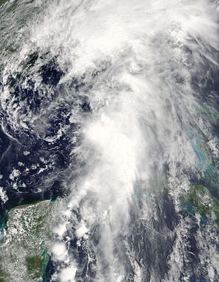
Tropical Storm Hermine was a near-hurricane strength tropical cyclone that brought widespread flooding from Guatemala northwards to Oklahoma in early September 2010. Though it was named in the western Gulf of Mexico, Hermine developed directly from the remnant low-pressure area associated with the short-lived Tropical Depression Eleven-E in the East Pacific. Throughout its lifespan, the storm caused 52 direct deaths and roughly US$740 million in damage to crops and infrastructure, primarily in Guatemala. The precursor tropical depression formed on September 3 in the Gulf of Tehuantepec and neared tropical storm intensity before making landfall near Salina Cruz, Mexico, on the next day. Though the depression quickly weakened to a remnant low, the disturbance crossed the Isthmus of Tehuantepec and tracked north into the warm waters of the Gulf of Mexico, where it reorganized into a tropical cyclone once again on September 5. There, the system quickly strengthened into a tropical storm and received the name Hermine before moving ashore near Matamoros, Mexico on September 7 as a high-end tropical storm. Over the next few days, Hermine weakened as it moved over the U.S. Southern Plains, eventually dissipating over Kansas on September 10.

<span class="mw-page-title-main">Hurricane Katia (2011)</span> Category 4 Atlantic hurricane in 2011

Hurricane Katia was a fairly intense Cape Verde hurricane that had substantial impact across Europe as a post-tropical cyclone. The eleventh named storm, second hurricane, and second major hurricane of the active 2011 Atlantic hurricane season, Katia originated as a tropical depression from a tropical wave over the eastern Atlantic on August 29. It intensified into a tropical storm the following day and further developed into a hurricane by September 1, although unfavorable atmospheric conditions hindered strengthening thereafter. As the storm began to recurve over the western Atlantic, a more hospitable regime allowed Katia to become a major hurricane by September 5 and peak as a Category 4 hurricane with winds of 140 mph (230 km/h) that afternoon. Internal core processes, increased wind shear, an impinging cold front, and increasingly cool ocean temperatures all prompted the cyclone to weaken almost immediately after peak, and Katia ultimately transitioned into an extratropical cyclone on September 10.

<span class="mw-page-title-main">Tropical Storm Beryl (2012)</span> Atlantic tropical storm in 2012

Tropical Storm Beryl was the strongest off-season Atlantic tropical cyclone on record to make landfall in the United States. The second tropical cyclone of the 2012 Atlantic hurricane season, Beryl developed on May 26 from a low-pressure system offshore North Carolina. Initially subtropical, the storm slowly acquired tropical characteristics as it tracked across warmer sea surface temperatures and within an environment of decreasing vertical wind shear. Late on May 27, Beryl transitioned into a tropical cyclone less than 120 miles (190 km) from North Florida. Early the following day, the storm moved ashore near Jacksonville Beach, Florida, with peak winds of 65 mph (100 km/h). It quickly weakened to a tropical depression, dropping heavy rainfall while moving slowly across the southeastern United States. A cold front turned Beryl to the northeast, and the storm became extratropical on May 30.

<span class="mw-page-title-main">2016 Atlantic hurricane season</span> Hurricane season in the Atlantic Ocean

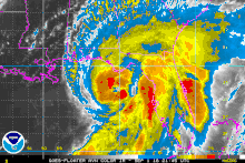
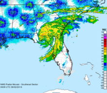
The 2016 Atlantic hurricane season was the deadliest Atlantic hurricane season since 2008, and the first above-average hurricane season since 2012, producing 15 named storms, 7 hurricanes and 4 major hurricanes. The season officially started on June 1 and ended on November 30, though the first storm, Hurricane Alex which formed in the Northeastern Atlantic, developed on January 12, being the first hurricane to develop in January since 1938. The final storm, Otto, crossed into the Eastern Pacific on November 25, a few days before the official end. Following Alex, Tropical Storm Bonnie brought flooding to South Carolina and portions of North Carolina. Tropical Storm Colin in early June brought minor flooding and wind damage to parts of the Southeastern United States, especially Florida. Hurricane Earl left 94 fatalities in the Dominican Republic and Mexico, 81 of which occurred in the latter. In early September, Hurricane Hermine, the first hurricane to make landfall in Florida since Hurricane Wilma in 2005, brought extensive coastal flooding damage especially to the Forgotten and Nature coasts of Florida. Hermine was responsible for five fatalities and about $550 million (2016 USD) in damage.

<span class="mw-page-title-main">2019 Atlantic hurricane season</span> Hurricane season in the Atlantic Ocean

The 2019 Atlantic hurricane season was the fourth consecutive above-average and damaging season dating back to 2016. However, many storms were weak and short-lived, especially towards the end of the season. Six of those named storms achieved hurricane status, while three intensified into major hurricanes. Two storms became Category 5 hurricanes, marking the fourth consecutive season with at least one Category 5 hurricane, the third consecutive season to feature at least one storm making landfall at Category 5 intensity, and the seventh on record to have multiple tropical cyclones reaching Category 5 strength. The season officially began on June 1 and ended on November 30. These dates historically describe the period each year when most tropical cyclones form in the Atlantic basin and are adopted by convention. However, tropical cyclogenesis is possible at any time of the year, as demonstrated by the formation of Subtropical Storm Andrea on May 20, making this the fifth consecutive year in which a tropical or subtropical cyclone developed outside of the official season.

<span class="mw-page-title-main">Tropical Storm Andrea (2013)</span> Atlantic Tropical storm in the 2013

Tropical Storm Andrea brought flooding to Cuba, the Yucatan Peninsula, and portions of the East Coast of the United States in June 2013. The first tropical cyclone and named storm of the annual hurricane season, Andrea originated from an area of low pressure in the eastern Gulf of Mexico on June 5. Despite strong wind shear and an abundance of dry air, the storm strengthened while initially heading north-northeastward. Later on June 5, it re-curved northeastward and approached the Big Bend region of Florida. Andrea intensified and peaked as a strong tropical storm with winds at 65 mph (105 km/h) on June 6. A few hours later, the storm weakened slightly and made landfall near Steinhatchee, Florida later that day. It began losing tropical characteristics while tracking across Florida and Georgia. Andrea transitioned into an extratropical cyclone over South Carolina on June 7, though the remnants continued to move along the East Coast of the United States, until being absorbed by another extratropical system offshore Maine on June 10.

<span class="mw-page-title-main">Tropical Storm Colin (2016)</span> Atlantic tropical storm in 2016

Tropical Storm Colin was the earliest third named storm in the Atlantic basin on record for four years, until it was surpassed by Tropical Storm Cristobal in 2020. An atypical, poorly organized tropical cyclone, Colin developed from a low pressure area over the Gulf of Mexico near the northern coast of the Yucatán Peninsula late on June 5, 2016. Moving northward, the depression strengthened into a tropical storm about eight hours after its formation. On June 6, Colin curved to the north-northeast and intensified slightly to winds of 50 mph (80 km/h). Strong wind shear prevented further strengthening and resulted in the system maintaining a disheveled appearance on satellite imagery. Later, the storm began accelerating to the northeast. Early on June 7, Colin made landfall in rural Taylor County, Florida, still at peak intensity. The system rapidly crossed northern Florida and emerged into the Atlantic Ocean several hours later. By late on June 7, Colin transitioned into an extratropical cyclone offshore North Carolina before being absorbed by a frontal boundary the following day.

<span class="mw-page-title-main">Tropical Storm Julia (2016)</span> Atlantic tropical storm in 2016

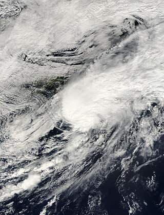
Tropical Storm Julia was a weak tropical cyclone that caused minor damage across the Eastern United States in September 2016. The tenth named storm of the 2016 Atlantic hurricane season, Julia developed from a tropical wave near the coast of east-central Florida on September 13. Initially a tropical depression, the system soon made landfall near Jensen Beach. Despite moving inland, the cyclone intensified into a tropical storm, shortly before strengthening further to reach maximum sustained winds of 50 mph (85 km/h). Julia then drifted north-northwestward and then northeastward, moving offshore the Southeastern United States on September 14. A cyclonic loop occurred as strong westerly air developed in the region, with the shear causing fluctuations in intensity. By September 19, Julia degenerated into a remnant low, which later transitioned into an extratropical cyclone and moved inland over North Carolina before dissipating on September 21.

<span class="mw-page-title-main">2022 Atlantic hurricane season</span> Hurricane season in the Atlantic Ocean

The 2022 Atlantic hurricane season was a very destructive Atlantic hurricane season, which had an average number of named storms, a slightly above-average number of hurricanes, a slightly below-average number of major hurricanes, and a near-average accumulated cyclone energy (ACE) index. Despite this, it became the third-costliest Atlantic hurricane season on record, behind only 2017 and 2005, mostly due to Hurricane Ian. The season officially began on June 1, and ended on November 30. These dates, adopted by convention, historically describe the period in each year when most subtropical or tropical cyclogenesis occurs in the Atlantic Ocean. This year's first Atlantic named storm, Tropical Storm Alex, developed five days after the start of the season, making this the first season since 2014 not to have a pre-season named storm.

References

  1. 1 2 3 4 5 6 7 8 9 10 11 12 Robbie J. Berg (January 30, 2017). Tropical Cyclone Report: Hurricane Hermine (PDF) (Report). National Hurricane Center. Retrieved February 1, 2017.
  2. Stacy Stewart (August 18, 2016). Tropical Weather Outlook (TXT) (Report). National Hurricane Center . Retrieved August 28, 2016.
  3. Jack Beven (August 19, 2016). Tropical Weather Outlook (TXT) (Report). National Hurricane Center. Retrieved August 28, 2016.
  4. Stacy Stewart (August 21, 2016). Tropical Weather Outlook (TXT) (Report). National Hurricane Center. Retrieved August 28, 2016.
  5. Todd Kimberlain (August 23, 2016). Tropical Weather Outlook (TXT) (Report). National Hurricane Center. Retrieved August 28, 2016.
  6. Todd Kimberlain (August 24, 2016). Tropical Weather Outlook (TXT) (Report). National Hurricane Center. Retrieved August 28, 2016.
  7. Daniel Brown (August 24, 2016). Tropical Weather Outlook (TXT) (Report). National Hurricane Center. Retrieved August 28, 2016.
  8. Daniel Brown (August 24, 2016). Tropical Weather Outlook (TXT) (Report). National Hurricane Center. Retrieved August 28, 2016.
  9. Jack Beven (August 25, 2016). Tropical Weather Outlook (TXT) (Report). National Hurricane Center. Retrieved August 28, 2016.
  10. Daniel Brown (August 25, 2016). Tropical Weather Outlook (TXT) (Report). National Hurricane Center. Retrieved August 28, 2016.
  11. Robbie Berg (August 27, 2016). Tropical Weather Outlook (TXT) (Report). National Hurricane Center. Retrieved August 28, 2016.
  12. 1 2 Lixion Avila (August 27, 2016). Tropical Weather Outlook (TXT) (Report). National Hurricane Center. Retrieved August 28, 2016.
  13. Daniel Brown (August 28, 2016). Tropical Weather Outlook (TXT) (Report). National Hurricane Center. Retrieved August 28, 2016.
  14. Michael Brennan (August 28, 2016). Tropical Weather Outlook (TXT) (Report). National Hurricane Center. Retrieved August 28, 2016.
  15. Michael Brennan (August 28, 2016). Tropical Depression Nine Discussion Number 1 (Report). National Hurricane Center. Retrieved August 28, 2016.
  16. Richard Pasch (August 29, 2016). Tropical Depression Nine Discussion Number 4 (Report). National Hurricane Center. Retrieved August 29, 2016.
  17. 1 2 Stacy Stewart (August 30, 2016). Tropical Depression Nine Discussion Number 6 (Report). National Hurricane Center. Retrieved August 31, 2016.
  18. Richard Pasch (August 29, 2016). Tropical Depression Nine Discussion Number 5 (Report). National Hurricane Center. Retrieved August 31, 2016.
  19. Richard Pasch (August 30, 2016). Tropical Depression Nine Discussion Number 9 (Report). National Hurricane Center. Retrieved August 31, 2016.
  20. Stacy Stewart (August 31, 2016). Tropical Depression Nine Discussion Number 10 (Report). National Hurricane Center. Retrieved August 31, 2016.
  21. Richard Pasch (August 31, 2016). Tropical Storm Hermine Intermediate Advisory Number 12A (Report). National Hurricane Center. Retrieved August 31, 2016.
  22. Richard Pasch (August 31, 2016). Tropical Storm Hermine Discussion Number 13 (Report). National Hurricane Center. Retrieved September 1, 2016.
  23. Stacy Stewart (September 1, 2016). Tropical Storm Hermine Discussion Number 14 (Report). National Hurricane Center. Retrieved September 1, 2016.
  24. Richard Pasch (September 1, 2016). Tropical Storm Hermine Discussion Number 16 (Report). National Hurricane Center. Retrieved September 1, 2016.
  25. Richard Pasch; James Franklin (September 1, 2016). Tropical Storm Hermine Special Discussion Number 17 (Report). National Hurricane Center. Retrieved September 1, 2016.
  26. Jack Beven (September 2, 2016). Hurricane Hermine Intermediate Advisory Number 18A (Report). National Hurricane Center. Retrieved September 3, 2016.
  27. 1 2 3 4 5 6 7 8 9 Jason Dearen (September 2, 2016). "After Slamming Florida, Hermine Threatens East Coast". ABC News . Associated Press. Archived from the original on September 11, 2016. Retrieved September 4, 2016.
  28. Lixion Avila (September 2, 2016). Tropical Storm Hermine Discussion Number 20 (Report). National Hurricane Center. Retrieved September 3, 2016.
  29. Michael Brennan (September 2, 2016). Tropical Storm Hermine Discussion Number 21 (Report). National Hurricane Center. Retrieved September 3, 2016.
  30. Michael Brennan (September 2, 2016). Tropical Storm Hermine Discussion Number 22 (Report). National Hurricane Center. Retrieved September 3, 2016.
  31. Michael Brennan (September 3, 2016). Post-Tropical Cyclone Hermine Discussion Number 26 (Report). National Hurricane Center. Retrieved September 4, 2016.
  32. Stacy Stewart (September 4, 2016). Post-Tropical Cyclone Hermine Discussion Number 28 (Report). National Hurricane Center. Retrieved September 4, 2016.
  33. Richard Pasch (September 5, 2016). Post-Tropical Cyclone Hermine Discussion Number 33 (Report). National Hurricane Center. Retrieved September 5, 2016.
  34. Daniel Brown; Chris Landsea (September 6, 2016). Post-Tropical Cyclone Hermine Discussion Number 35 (Report). National Hurricane Center. Retrieved September 6, 2016.
  35. John Cangialosi (September 6, 2016). Post-Tropical Cyclone Hermine Discussion Number 36 (Report). National Hurricane Center. Retrieved September 6, 2016.
  36. Jack Beven (September 6, 2016). Post-Tropical Cyclone Hermine Discussion Number 38 (Report). National Hurricane Center. Retrieved September 6, 2016.
  37. 1 2 3 Eric Chaney and Pam Wright (September 1, 2016). "51 Florida Counties Now Under State of Emergency as Hermine Approaches". The Weather Channel. Archived from the original on September 3, 2016. Retrieved September 2, 2016.
  38. Joe Callahan (August 25, 2016). "Storm causes state to encourage early voting". Star-Banner . Retrieved September 2, 2016.
  39. "Gov. Scott: While Hurricane Hermine has Passed Through Our State, Floridians Must Continue to Take Safety Precautions" (PDF). Tallahassee, Florida: Florida Division of Emergency Management. September 2, 2016. Retrieved September 2, 2016.
  40. 1 2 3 4 5 Fieldstadt, Elisha (September 3, 2016). "Hermine to Deliver 'Life-Threatening' Surf, Winds From North Carolina to New England". NBC News. Retrieved September 3, 2016.
  41. 1 2 Jessica Gresko. "Hermine kills 2, ruins beach weekends in northward march". KATC . Archived from the original on September 4, 2016. Retrieved September 3, 2016.{{cite news}}: CS1 maint: bot: original URL status unknown (link)
  42. 1 2 3 4 5 6 7 8 9 10 "The Latest: Storm surge likely up coast from Virginia to NJ". Reisterstown, Maryland. Associated Press. September 3, 2016. Archived from the original on September 24, 2016. Retrieved September 4, 2016.
  43. "Cancelations, concerts go indoors at the American Music Festival". WVEC/13 News Now . Norfolk, VA: TEGNA. September 2, 2016. Archived from the original on September 5, 2016. Retrieved September 4, 2016.
  44. Vanessa Bent (August 25, 2016). "APUA restores Electricity but prepares residents for load-shedding". ZDK-FM. Retrieved February 2, 2017.
  45. Jeff Masters and Bob Henson (August 25, 2016). "Is the Wait-and-See Game With 99L Ending? Also, Tornadoes Rip Indiana and Ohio". Weather Underground . Retrieved February 2, 2017.
  46. "Storm Data and Unusual Weather Phenomena with Late Reports and Corrections" (PDF). Storm Data and Unusual Weather Phenomena . Asheville, North Carolina: National Oceanic and Atmospheric Administration. 58 (8): 447 448. ISSN   0039-1972. Archived from the original (PDF) on March 22, 2017. Retrieved March 22, 2017.
  47. Sancheska Brown (August 26, 2016). "Heavy Rain And Storm Warning For Residents In Southeast Bahamas". Tribune242. Retrieved September 2, 2016.
  48. Dominican Republic – Severe weather (ONAMET, Local Media) (ECHO Daily Flash of 26 August 2016). Directorate-General for European Civil Protection and Humanitarian Aid Operations (Report). ReliefWeb. August 26, 2016. Retrieved September 2, 2016.
  49. 1 2 3 "Alertan de inundaciones repentinas en Cuba por intensas lluvias" (in Spanish). Marti Noticas. August 30, 2016. Retrieved August 31, 2016.
  50. "Temporal de lluvias provoca inundación en una localidad costera" (in Spanish). El Mundo. EFE. August 30, 2016. Archived from the original on September 1, 2016. Retrieved August 31, 2016.
  51. Sonali Basak (September 19, 2016). "Hurricane Hermine Seen Costing Insurers Less Than $400 Million". Bloomberg. Retrieved September 25, 2016.
  52. "Hermine claims estimated at $80 million". Panama City News Herald. Tallahassee, Florida. September 20, 2016. Retrieved September 25, 2016.
  53. Jack Beven (September 1, 2016). Hurricane Hermine Advisory Number 19 (Report). National Hurricane Center. Retrieved September 3, 2016.
  54. Lixion Avila; Stacy Stewart (September 2, 2016). Hurricane Hermine Tropical Cyclone Update (Report). National Hurricane Center. Retrieved September 3, 2016.
  55. 1 2 John McMichael (September 6, 2016). Post Tropical Cyclone Report... Hurricane Hermine (TXT) (Report). Retrieved September 6, 2016.
  56. Public Information Statement...Correction (Report). Tampa Bay Area, Florida National Weather Service. September 2, 2016. Archived from the original on September 24, 2016. Retrieved September 3, 2016.
  57. EF-0 Hamlin Grove Tornado (PDF) (Report). Melbourne, Florida National Weather Service. September 1, 2016. Retrieved September 4, 2016.
  58. 1 2 3 4 5 6 7 8 9 10 11 12 13 14 15 16 17 18 19 20 21 22 23 "Storm Data and Unusual Weather Phenomena with Late Reports and Corrections" (PDF). Storm Data and Unusual Weather Phenomena . Asheville, North Carolina: National Oceanic and Atmospheric Administration. 58 (9). ISSN   0039-1972. Archived from the original (PDF) on March 22, 2017. Retrieved March 22, 2017.
  59. Jeff Burlew (September 9, 2016). "Hermine cost city and county more than $10 million". Tallahassee Democrat. Retrieved September 9, 2016.
  60. Karl Etters (September 2, 2016). "Panacea marine lab takes a hit". Tallahassee Democrat. Retrieved February 3, 2017.
  61. "Hurricane Hermine Hits Home". ECB Publishing. September 6, 2016. Retrieved March 17, 2017.
  62. Gov. Scott: While Hurricane Hermine has Passed Through Our State, Floridians Must Continue to Take Safety Precautions (PDF) (Report). Tallahassee, Florida: Florida Division of Emergency Management. September 2, 2016. Retrieved March 17, 2017.
  63. Rick Patrick (September 6, 2016). "Hurricane Hermine hits area". Greene Publishing, Inc. Retrieved March 28, 2017.
  64. Michael Buczyner (September 2, 2016). "12 people rescued in Taylor County". WPEC . Retrieved September 2, 2016.
  65. 1 2 Josh Soloman (September 2, 2016). "Dazed Cedar Key deals with the aftermath of Hurricane Hermine". Tampa Bay Times. Retrieved September 3, 2016.
  66. Ryan Hughes (November 22, 2016). "Cedar Key on road to recovery 3 months after Hurricane Hermine". WFLA. Cedar Key, Florida. Retrieved February 27, 2017.
  67. Amy Mariani (September 8, 2016). "Thousands of Citrus Co. properties were damaged in Hurricane Hermine". Bay News 9. Retrieved September 9, 2016.
  68. "Officials: Hermine caused $7.7M in damage in Hernando". WTSP. September 5, 2016. Retrieved September 7, 2016.
  69. Charlie Frago (September 2, 2016). "Hurricane Hermine leaves Tampa Bay area befouled". Tampa Bay Times. Retrieved September 4, 2016.
  70. Mary McGuire (September 11, 2016). "Hermine damage estimates rise to $111 million in Pasco". WFLA. Retrieved September 15, 2016.
  71. Jeff Patterson (September 7, 2016). "With $89 million in damage, Hermine may be one of Pasco's most expensive storms". WFLA. Retrieved September 7, 2016.
  72. Jeff Patterson (September 7, 2016). "Hurricane Hermine caused nearly $90 million damage in Pasco". WFLA. Retrieved September 7, 2016.
  73. C.T. Bowen (September 15, 2016). "A flood of second guessing follows Hermine". Tampa Bay Times. Retrieved September 15, 2016.
  74. 1 2 "Cops: Man found dead under tree as Hurricane Hermine hits Florida". ClickOrlando. September 2, 2016. Retrieved September 2, 2016.
  75. 1 2 Post Tropical Cyclone Report... Hurricane Hermine (Report). Jacksonville, Florida National Weather Service. September 7, 2016. Archived from the original (TXT) on September 14, 2016. Retrieved September 7, 2016.
  76. Michael Brennan (September 2, 2016). Tropical Storm Hermine Intermediate Advisory Number 21 (Report). National Hurricane Center. Retrieved September 3, 2016.
  77. Michael Brennan (September 2, 2016). Tropical Storm Hermine Intermediate Advisory Number 22 (Report). National Hurricane Center. Retrieved September 3, 2016.
  78. Michael Brennan (September 3, 2016). Post-Tropical Cyclone Hermine Intermediate Advisory Number 25 (Report). National Hurricane Center. Retrieved September 3, 2016.
  79. Public Information Statement (PDF) (Report). Wilmington, North Carolina National Weather Service. September 3, 2016. Retrieved September 4, 2016.
  80. Michael Brennan (September 3, 2016). Post-Tropical Cyclone Hermine Intermediate Advisory Number 26 (Report). National Hurricane Center. Retrieved September 3, 2016.
  81. "Hermine Leaves Thousands Without Power in Carolinas, Now Heads Toward Virginia". ABC News. September 3, 2016. Retrieved September 3, 2016.
  82. "Little impact expected locally from Hermine; 58,000 in Hampton Roads without power". Richmond Times-Dispatch. Associated Press. September 3, 2016. Retrieved September 4, 2016.
  83. Public Information Statement (Report). Charleston, South Carolina National Weather Service. September 4, 2016. Archived from the original on September 24, 2016. Retrieved September 5, 2016.
  84. Noelani Mathews (September 5, 2016). "Hermine causes millions in damage to South Georgia pecan farm". WCTV. Ray City, Georgia. Retrieved September 7, 2016.
  85. 1 2 Terry Richards (September 2, 2016). "Valdosta weathers storm". The Valdosta Daily Times . Retrieved April 26, 2017.
  86. Michael Praats (September 3, 2016). "Power outages continue after the storm". The Valdosta Daily Times. Retrieved April 26, 2017.
  87. Michael Praats (September 14, 2016). "County green lights replacing bridge". The Valdosta Daily Times. Retrieved April 26, 2017.
  88. "Man removing tree that fell in Hermine struck, killed by car". The Herald. Associated Press. Archived from the original on September 11, 2016. Retrieved September 5, 2016.
  89. Tropical Storm Hermine September 2016 (Report). National Weather Service Charleston, South Carolina. 2016. Retrieved September 26, 2017.
  90. Jessica Gresko (September 4, 2016). "Hermine soaks Virginia after slamming Florida". Associated Press. Retrieved September 4, 2016.
  91. Rob Morris (September 8, 2016). "New assessment doubles Dare's storm damage to $5.4 million". The Outer Banks Voice. Retrieved September 9, 2016.
  92. Kimberly Pierceall, Robyn Sidersky, and Jeff Hampton (September 3, 2016). "Hermine soaks Hampton Roads and Outer Banks, foils tourists' plans". The Virginian-Pilot . Retrieved April 16, 2017.{{cite news}}: CS1 maint: multiple names: authors list (link)
  93. Elisha Fieldstadt (September 4, 2016). "'Far From Over': Hermine to Batter Northeast Coast With High Winds, Storm Surges". NBC. Retrieved September 4, 2016.
  94. "Bodies of 2 missing fishermen found on beach in Shoreham, Long Island". WABC-TV . September 4, 2016. Retrieved September 4, 2016.
  95. Richard Pasch (September 5, 2016). Post-Tropical Cyclone Hermine Intermediate Advisory Number 33A (Report). National Hurricane Center. Retrieved September 5, 2016.
  96. "Cruise ship battles high seas, 100+ mph winds in Hermine remnants". WNCN . September 4, 2016. Retrieved September 5, 2016.
  97. Florida Hurricane Hermine FEMA-4280-DR (PDF) (Report). Federal Emergency Management Agency. September 28, 2016. Retrieved April 26, 2017.
  98. "FEMA-4280-DR, Florida Disaster Declaration as of 11/02/2016" (PDF). Federal Emergency Management Agency. November 2, 2016. Retrieved April 26, 2017.
  99. "Additional funding approved for citizens impacted by Hurricane Hermine". WCTV. November 2, 2016. Retrieved April 26, 2017.
  100. Delia D'Ambra (September 4, 2016). "Hurricane Hermine leaves cleanup for county crews". WBBH-TV . Retrieved September 10, 2016.
  101. Mike Konrad (September 4, 2016). "Initial damage assessment in Hernando shows two homes destroyed by Hermine". Tampa Bay Times. Retrieved September 5, 2016.
  102. Crystal Bailey (February 7, 2017). "Cedar Key Post Office up and running 5 months after Hermine". WCJB-TV . Cedar Key, Florida. Archived from the original on February 27, 2017. Retrieved February 27, 2017.
  103. "City Commission Meets 04 April 2017". Cedar Key News. April 4, 2017. Retrieved April 26, 2017.
  104. Samantha Read (September 5, 2016). "Multiple agencies tag-team Hurricane Hermine clean up in Franklin County". WJHG-TV . Retrieved April 26, 2017.
Hurricane Hermine
Hermine 2016-09-01 2300Z.png
Hurricane Hermine near peak strength, just before landfall in Florida, on September 1