Kars okrug

Last updated
Kars okrug
Карсскій округъ
Coat of arms of Kars Oblast 1881.svg
Kars Okrug of Kars Oblast.png
Location in the Kars Oblast
Country Russian Empire
Viceroyalty Caucasus
Oblast Kars
Established1878
Treaty of Brest-Litovsk 3 March 1918
Capital Kars
Area
  Total5,785.69 km2 (2,233.87 sq mi)
Population
 (1916)
  Total191,970
  Density33/km2 (86/sq mi)
   Urban
15.90%
   Rural
84.10%

The Kars okrug [lower-alpha 1] was a district ( okrug ) of the Kars Oblast of the Russian Empire between 1878 and 1918. Its capital was the city of Kars, presently part of the Kars Province of Turkey and the Amasia District of Armenia. The okrug bordered with the Ardahan okrug in the north, the Kagizman okrug in the south, the Olti okrug in the west, and the Erivan Governorate to its east. [1]

Contents

History

The Kars okrug was one of the four territorial administrative subunits (counties) of the Kars oblast created after its annexation into the Russian Empire in 1878 through the Treaty of San Stefano, following the defeat of the Ottoman Empire. [2]

During World War I, the Kars Oblast became the site of intense battles between the Russian Caucasus Army supplemented by Armenian volunteers and the Ottoman Third Army, the latter of whom was successful in briefly occupying Ardahan on 25 December 1914 before they were dislodged in early January 1915.

On 3 March 1918, in the aftermath of the October Revolution the Russian SFSR ceded the entire Kars Oblast including the Kars okrug through the Treaty of Brest-Litovsk to the Ottoman Empire, who had been unreconciled with its loss of the territory since 1878. Despite the ineffectual resistance of the Transcaucasian Democratic Federative Republic which had initially rejected the aforementioned treaty, the Ottoman Third Army was successful in occupying the Kars Oblast and expelling its 100,000 panic-stricken Armenian inhabitants. [3]

The Ottoman Ninth Army under the command of Yakub Shevki Pasha, the occupying force of the district by the time of the Mudros Armistice, were permitted to winter in Kars until early 1919, after which on 7 January 1919 Major General G.T. Forestier-Walker ordered their complete withdrawal to the pre-1914 Ottoman-frontier. Intended to hinder the westward expansion of the fledgling Armenian and Georgian republics into the Kars Oblast, Yukub Shevki backed the emergence of the short-lived South-West Caucasus Republic with moral support, also furnishing it with weapons, ammunition and instructors. [4]

The South-West Caucasus Republic administered the Kars okrug and neighboring formerly occupied districts for three months before provoking British intervention by order of General G.F. Milne, leading to its capitulation by Armenian and British forces on 10 April 1919. [5] [6] Consequently, the Kars Oblast largely came under the Armenian civil governorship of Stepan Korganian who wasted no time in facilitating the repatriation of the region's exiled refugees. [7]

Despite the apparent defeat of the Ottoman Empire, Turkish agitators were reported by Armenian intelligence to have been freely roaming the countryside of Kars encouraging sedition among the Muslim villages, culminating in a series of anti-Armenian uprisings on 1 July 1919. [8]

The Kars Oblast for the third time in six years saw invading Turkish troops, this time under the command of General Kâzım Karabekir in September 1920 during the Turkish-Armenian War. The disastrous war for Armenia resulted in the permanent expulsion of the region's ethnic Armenian population, many who inexorably remained befalling massacre, resulting in the region joining the Republic of Turkey through the Treaty of Alexandropol on 3 December 1920. Turkey's annexation of Kars and the adjacent Surmalu Uyezd was confirmed in the treaties of Kars and Moscow in 1921, by virtue of the new Soviet regime in Armenia. [9] Again according to them, most of Aghbaba uchastok went to Soviet Armenia, remainder of it went to Turkey.

Administrative divisions

The subcounties ( uchastoks ) of the Kars okrug were: [10]

Name1912 populationArea
Agbabinskiy uchastok (Агбабинскій участокъ)14,309570.96 square versts (649.79  km2 ; 250.88  sq mi )
Zarushadskiy uchastok (Зарушадскій участокъ)19,4161,104.11 square versts (1,256.55  km2 ; 485.16  sq mi )
Karsskiy uchastok (Карсскій участокъ)29,5741,352.94 square versts (1,539.73  km2 ; 594.49  sq mi )
Soganlugskiy uchastok (Соганлугскій участокъ)23,8211,044.04 square versts (1,188.18  km2 ; 458.76  sq mi )
Shuragelskiy uchastok (Шурагельскій участокъ)39,3691,011.76 square versts (1,151.45  km2 ; 444.58  sq mi )

Demographics

Russian Empire Census

According to the Russian Empire Census, the Kars okrug had a population of 134,142 on 28 January [ O.S. 15 January] 1897, including 75,452 men and 58,690 women. The plurality of the population indicated Armenian to be their mother tongue, with significant Karapapakh, Russian, Greek, Turkish, and Kurdish speaking minorities. [11]

Linguistic composition of the Kars okrug in 1897 [11]
LanguageNative speakers%
Armenian 46,71534.83
Karapapakh 22,00216.40
Russian 16,87412.58
Greek 14,80511.04
Turkish 10,6097.91
Kurdish 9,1656.83
Ukrainian 3,2972.46
Turkmen 2,4561.83
Polish 2,0931.56
Tatar [lower-alpha 2] 1,4391.07
Jewish 7550.56
Lithuanian 6110.46
Assyrian 5850.44
Estonian 4240.32
Ossetian 4010.30
Persian 3170.24
Georgian 3080.23
German 2940.22
Avar-Andean 2760.21
Bashkir 2060.15
Belarusian 2050.15
Dargin 950.07
Other2100.16
TOTAL134,142100.00

Kavkazskiy kalendar

According to the 1917 publication of Kavkazskiy kalendar , the Kars okrug had a population of 191,970 on 14 January [ O.S. 1 January] 1916, including 97,919 men and 94,051 women, 153,102 of whom were the permanent population, and 38,868 were temporary residents. The statistics indicated an overwhelmingly Armenian population in the city of Kars, with sizeable Asiatic Christian, Russian, and Sunni Muslim minorities, however, in the rest of the okrug, Armenians formed the plurality of the population, being closely followed by Sunni Muslim, Roma, Shia Muslim, Russian, Kurdish and Yazidi minorities: [14]

Nationality Urban Rural TOTAL
Number%Number%Number%
Armenians 25,66584.1155,08734.1280,75242.06
Sunni Muslims [lower-alpha 3] 1,2103.9731,35519.4232,56516.96
Roma 00.0023,50414.5623,50412.24
Shia Muslims [lower-alpha 4] 2600.8517,96511.1318,2259.49
Russians 1,4874.8714,4938.9815,9808.32
Kurds 380.1210,8736.7310,9115.68
Yazidis 00.005,1233.175,1232.67
Asiatic Christians 1,7795.831,3500.843,1291.63
North Caucasians 00.008690.548690.45
Other Europeans 490.167330.457820.41
Georgians 10.001040.061050.05
Jews 250.0800.00250.01
TOTAL30,514100.00161,456100.00191,970100.00

Notes

  1. Before 1918, Azerbaijanis were generally known as "Tatars". This term, employed by the Russians, referred to Turkic-speaking Muslims of the South Caucasus. After 1918, with the establishment of the Azerbaijan Democratic Republic and "especially during the Soviet era", the Tatar group identified itself as "Azerbaijani". [12] [13]
  2. Primarily Turco-Tatars. [15]
  3. Primarily Tatars. [15]

Related Research Articles

Kars <i>oblast</i> Oblast in Caucasus, Russian Empire

The Kars oblast was a province (oblast) of the Caucasus Viceroyalty of the Russian Empire between 1878 and 1917. Its capital was the city of Kars, presently in Turkey. The oblast bordered the Ottoman Empire to the west, the Batum Oblast to the north, the Tiflis Governorate to the northeast, and the Erivan Governorate to the east. The Kars oblast included parts of the contemporary provinces of Kars, Ardahan, and Erzurum Province of Turkey, and the Amasia Community of the Shirak Province of Armenia.

Borchaly <i>uezd</i> Uezd in Caucasus, Russian Empire

The Borchaly uezd was a county (uezd) of the Tiflis Governorate of the Caucasus Viceroyalty of the Russian Empire, and later of the independent and Soviet republics of Georgia. Its administrative center was the town of Shulavery. The area of the county roughly corresponded to the contemporary Lori Province of Armenia and the Kvemo Kartli region of Georgia.

Dagestan <i>Oblast</i> Province of the Russian Empire from 1860 to 1917

The Dagestan Oblast was a province (oblast) of the Caucasus Viceroyalty of the Russian Empire. It roughly corresponded to most of present-day southeastern Dagestan within the Russian Federation. The Dagestan oblast was created in 1860 out of the territories of the former Caucasian Imamate, bordering the Terek Oblast to the north, the Tiflis Governorate and Zakatal Okrug to the west, the Elizavetpol Governorate to the south, and Baku Governorate to the east. The administrative center of the oblast was Temir-Khan-Shura.

Batum <i>oblast</i> Oblast of the Russian Empire

The Batum oblast was a province (oblast) of the Caucasus Viceroyalty of the Russian Empire, with the Black Sea port of Batum as its administrative center. The Batum oblast roughly corresponded to most of present-day southwestern Georgia, and part of the Artvin Province of Turkey.

Zakatal <i>okrug</i> Former county in Caucasus, Russian Empire

The Zakatal okrug was a special administrative district (okrug) of the Caucasus Viceroyalty of the Russian Empire, part of the Tiflis Governorate from 1893 to 1905. The administrative centre of the district was Zakataly, and it corresponded to most of the contemporary districts of Balakan, Zaqatala and Qax of Azerbaijan. The Zakatal okrug was established from the territories of the erstwhile Free Jamaats of Jar-Balakan, bordering the Tiflis Governorate to the west, the Elizavetpol Governorate to the south and the Dagestan Oblast to the north. The district was the smallest independent administrative unit of the Russian Empire, similarly to the Sukhumi okrug.

Surmalu <i>uezd</i> Uezd in Caucasus, Russian Empire

The Surmalu uezd was a county (uezd) of the Erivan Governorate of the Caucasus Viceroyalty of the Russian Empire. It bordered the governorate's Etchmiadzin and Erivan uezds to the north, the Kars Oblast to the west, Persia to the east, and the Ottoman Empire to the south. The district made up most of the Iğdır Province of present-day Turkey. As part of the Russian Transcaucasus, the Surmalu uezd possessed economical importance for its abundantly rich salt mines in Kulp (Tuzluca), and spiritual importance to Armenians as the location of the culturally significant Mount Ararat. The administrative centre of the county was Igdyr.

Alexandropol <i>uezd</i> Uezd in Caucasus, Russian Empire

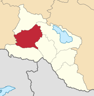
The Alexandropol uezd, known after 1924 as the Leninakan uezd, was a county (uezd) of the Erivan Governorate of the Caucasus Viceroyalty of the Russian Empire. The uezd bordered the governorate's Etchmiadzin and Nor Bayazet uezds to the south, the Borchaly and Akhalkalaki uezds of the Tiflis Governorate to the north, the Kazakh uezd of the Elizavetpol Governorate to the east, and the Kars Oblast to the west. The area of the uezd included most of the contemporary Shirak Province, and southern parts of the Lori Province of Armenia. The district was eponymously named for its administrative center, Aleksandropol, which at the time was a major railway hub of the Russian South Caucasus.

Etchmiadzin <i>uezd</i> Uezd in Caucasus, Russian Empire

The Etchmiadzin uezd was a county (uezd) of the Erivan Governorate of the Caucasus Viceroyalty of the Russian Empire. The uezd bordered the Alexandropol uezd to the north, the Nor Bayazet uezd to the east, Erivan uezd to the north, the Surmalu uezd to the south, and the Kars Oblast to the west. It included all of the Armavir Province and most of the Aragatsotn Province of present-day Armenia. The administrative centre of the county was Vagorshapat (Vagharshapat), also referred to as Etchmiadzin—the administrative capital of the Armenian Apostolic Church.

Ardahan <i>okrug</i> Okrug in Caucasus, Russian Empire

The Ardahan okrug was a district (okrug) of the Kars Oblast of the Russian Empire between 1878 and 1918. The district was eponymously named for its administrative center, the town of Ardagan, presently part of the Ardahan Province of Turkey. The okrug bordered with the Kars okrug to the south, the Olti okrug in the west, the Batum Oblast in the north, the Tiflis Governorate in the northeast, and from 1883 to 1903 the Kutais Governorate whilst the latter included the Artvin and Batum okrugs.

Olti <i>okrug</i> Okrug in Caucasus, Russian Empire

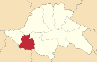
The Olti okrug was a district (okrug) of the Kars Oblast of the Russian Empire existing between 1878 and 1918. Its capital was the town of Olty, presently part of the Erzurum Province of Turkey. The okrug bordered with the Kars okrug to the southeast, the Ardahan okrug to the northwest, the Kagizman okrug to its south, the Batum Oblast to the north, and the Erzurum vilayet of the Ottoman Empire to the west.

Kagizman <i>okrug</i> Okrug in Caucasus, Russian Empire

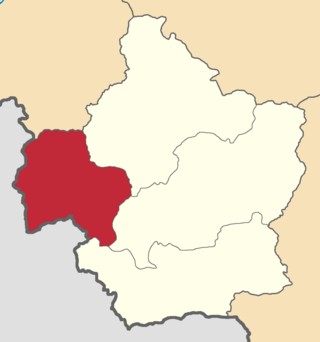
The Kagizman okrug was a district (okrug) of the Kars Oblast of the Russian Empire, existing between 1878 and 1918. Its capital was the town of Kagyzman, presently in the Kars Province of Turkey. The okrug bordered with the Kars okrug to the north, the Olti okrug to the northwest, the Erivan Governorate to the east, and the Erzurum Vilayet of the Ottoman Empire to the west.

Akhalkalaki <i>uezd</i> Uezd in Caucasus, Russian Empire

The Akhalkalaki uezd was a county (uezd) of the Tiflis Governorate of the Caucasus Viceroyalty of the Russian Empire, and then of Democratic Republic of Georgia, with its administrative centre in Akhalkalak. The county bordered the Gori uezd to the north, the Borchaly uezd to the east, the Alexandropol uezd of the Erivan Governorate and the Kars and Ardahan okrugs of the Kars Oblast to the south, and the Akhaltsikhe uezd to the west. The area of the county roughly corresponded to the contemporary Samtskhe–Javakheti region of Georgia.

Akhaltsikhe <i>uezd</i> Uezd in Caucasus, Russian Empire

The Akhaltsikhe uezd was a county (uezd) of the Tiflis Governorate of the Caucasus Viceroyalty of the Russian Empire, and then of Democratic Republic of Georgia, with its administrative center in Akhaltsikh. The uezd bordered the Gori uezd and the Kutaisi Governorate to the north, the Akhalkalaki uezd to the east, the Ardahan Okrug of the Kars Oblast to the south, and the Batum Okrug of the Batum Oblast to the west. The area of the uezd roughly corresponded to the contemporary Samtskhe-Javakheti region of Georgia.

Artvin <i>okrug</i> Okrug in Caucasus, Russian Empire

The Artvin okrug was a district (okrug) of the Batum Oblast of the Russian Empire, existing between 1878 and 1918. The district was eponymously named for its administrative centre, Artvin, presently part of the Artvin Province of Turkey. The district bordered with the Olti okrug to the south, the Ardahan okrug to the east, the Batumi okrug to the north, and the Ottoman Empire to the west. Between 1883 and 1903, the Artvin okrug formed a part of the Kutaisi Governorate.

Batumi <i>okrug</i> Okrug in Caucasus, Russian Empire

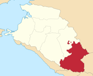
The Batumi okrug was a district (okrug) of the Batum Oblast of the Russian Empire existing between 1878 and 1918. The district was eponymously named for its administrative center, the town of Batum, now part of Adjara within Georgia. The okrug bordered with the Artvin okrug in the south, the Ardahan okrug of the Kars Oblast to the southeast, the Tiflis Governorate to the northeast, the Kutaisi Governorate to the north, and the Trebizond Vilayet of the Ottoman Empire to the west.

Sochinsky <i>okrug</i> Okrug in Caucasus, Russian Empire

The Sochinsky okrug was a district (okrug) of the Black Sea Governorate of the Caucasus Viceroyalty of the Russian Empire. It bordered the Kuban Oblast to the north, the Tuapsinsky okrug to the west, the Sukhumi okrug to the east, and the Black Sea to the south. The area of the Sochinsky okrug mostly corresponds to the Krasnodar Krai region of the Russian Federation. The district was eponymously named for its administrative centre, Sochi.

Batalpashinsky <i>otdel</i> Otdel in Caucasus, Russian Empire

The Batalpashinsky otdel was a Cossack district of the Kuban oblast of the Caucasus Viceroyalty of the Russian Empire. It bordered the Stavropol Governorate to the north, the Labinsky and Maykopsky otdels to the west, the Sochi and Sukhumi okrugs to the south, and the Terek Oblast to the east. The area of the Batalpashinsky otdel included most of the contemporary Karachay-Cherkessia region of Russia. The administrative capital was the city of Batalpashinskaya.

<i>Gunibsky okrug</i> Okrug in Caucasus, Russian Empire

The Gunibsky okrug was a district (okrug) of the Dagestan Oblast of the Caucasus Viceroyalty of the Russian Empire. The area of the Gunibsky okrug is included in contemporary Dagestan of the Russian Federation. The district's centre was Gunib.

<i>Kaytago-Tabasaransky okrug</i> Okrug in Caucasus, Russian Empire

The Kaytago-Tabasaransky okrug was a district (okrug) of the Dagestan Oblast of the Caucasus Viceroyalty of the Russian Empire. The area of the Kaytago-Tabasaransky okrug is included in contemporary Dagestan of the Russian Federation. The district's administrative centre was Madzhalis.

<i>Temir-Khan-Shurinsky okrug</i> Okrug in Caucasus, Russian Empire

The Temir-Khan-Shurinsky okrug was a district (okrug) of the Dagestan Oblast of the Caucasus Viceroyalty of the Russian Empire. The area of the Temir-Khan-Shurinsky okrug is included in contemporary Dagestan of the Russian Federation. The district's administrative centre was Temir-Khan-Shura.

References

  1. Tsutsiev 2014.
  2. "КАРССКАЯ ОБЛАСТЬ — информация на портале Энциклопедия Всемирная история". w.histrf.ru. Retrieved 2021-12-05.
  3. Hovannisian, Richard G. (1971–1996). The Republic of Armenia. Berkeley: University of California Press. p. 27. ISBN   0-520-01805-2. OCLC   238471.
  4. Hovannisian, Richard G. (1971–1996). The Republic of Armenia. Berkeley: University of California Press. p. 201. ISBN   0-520-01805-2. OCLC   238471.
  5. Andersen, Andrew. "Armenia in the Aftermath of Mudros: Conflicting claims and Strife with the Neighbors".
  6. Hovannisian, Richard G. (1971–1996). The Republic of Armenia. Berkeley: University of California Press. p. 220. ISBN   0-520-01805-2. OCLC   238471.
  7. Hovannisian, Richard G. (1971–1996). The Republic of Armenia. Berkeley: University of California Press. p. 204. ISBN   0-520-01805-2. OCLC   238471.
  8. Hovannisian, Richard G. (1971–1996). The Republic of Armenia. Berkeley: University of California Press. p. 66. ISBN   0-520-01805-2. OCLC   238471.
  9. De Waal, Thomas (2015). Great catastrophe : Armenians and Turks in the shadow of genocide. Oxford. p. 86. ISBN   978-0-19-935070-4. OCLC   897378977.{{cite book}}: CS1 maint: location missing publisher (link)
  10. Кавказский календарь на 1913 год, pp. 156–163.
  11. 1 2 "Демоскоп Weekly - Приложение. Справочник статистических показателей". www.demoscope.ru. Retrieved 2022-03-26.
  12. Bournoutian 2018, p. 35 (note 25).
  13. Tsutsiev 2014, p. 50.
  14. Кавказский календарь на 1917 год, pp. 198–201.
  15. 1 2 Hovannisian 1971, p. 67.

Bibliography

40°36′25″N43°05′35″E / 40.6069°N 43.0931°E / 40.6069; 43.0931