The Republic of Rose Island was a short-lived micronation on a man-made platform in the Adriatic Sea, 11 kilometres (6.8 mi) off the coast of the province of Rimini, Italy.

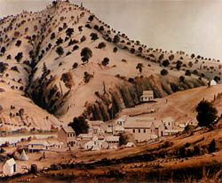
Bidwell's Bar was a gold mining camp in Butte County, California, United States, which lay at the end of the California Trail. It was located 6.5 miles (10.5 km) east-northeast of Oroville, at an elevation of 902 feet.

Jenny Lind is an unincorporated community in Calaveras County, California. It lies at an elevation of 253 feet and is located at 38°6′N120°52′W. The community is in ZIP code 95252 and area code 209.

The Shores of Poker Flat is an unincorporated community in Calaveras County, California. It lies at an elevation of 584 feet above sea level and is located at 37°54′11″N120°34′56″W, on the shore of the Tulloch Reservoir. The community is in ZIP code 95228 and area code 209.

Nortonville is a former settlement in Contra Costa County, California. It was located on Kirker Creek 5.5 miles (9 km) north-northeast of Mount Diablo, at an elevation of 801 feet. It is now a ghost town.

East Biggs is a small unincorporated community in Butte County, California. Its zip code is 95917 and its area code is 530. It lies at an elevation of 121 feet.

Dayton is a small unincorporated community in Butte County, California. Its zip code is 95928 and its area code is 530. It lies at an elevation of 141 feet.

Verona is an unincorporated community in Alameda County, California. It is located on the Western Pacific and the Southern Pacific Railroads 2.25 miles (3.6 km) north of Sunol, at an elevation of 315 feet.
Rose Garden is a former settlement in Yolo County, California. It was located on the railroad half a mile northwest of Mikon.

Latrobe is an unincorporated community in El Dorado County, California. It is located 15 miles (24 km) southwest of Placerville, at an elevation of 761 feet.
Pueblo de las Juntas is a former settlement in Fresno County, California situated at the confluence of the San Joaquin River and Fresno Slough, 2 miles (3.2 km) north of Mendota.

Coso Junction is an unincorporated community in Inyo County, California. It is located in Rose Valley, 4.8 km (3 mi) south of Dunmovin and 11.2 km (7 mi) west of Sugarloaf Mountain, at an elevation of 3386 feet.

Asphalto is a former settlement in Kern County, California. It was located on the railroad 3 miles (4.8 km) northeast of McKittrick, at an elevation of 932 feet. Asphalto still appeared on maps as of 1932.

Rose Place is an unincorporated community in Lake County, California. It is located 5 miles (8 km) east of Upper Lake, at an elevation of 3113 feet.

La Barr Meadows is a former settlement in Nevada County, California, located near Grass Valley. It was listed on an official map as of 1949.

Mount Bullion is an unincorporated community in Mariposa County, California. It is located 6 miles (9.7 km) southeast of Bear Valley, at an elevation of 2152 feet.
Lema is a former Pomo settlement in Mendocino County, California. It was located 4 miles (6.4 km) northwest of Hopland.

La Branza is a former settlement in Merced County, California. It was located on the Southern Pacific Railroad 5.5 miles (8.9 km) southwest of Le Grand, at an elevation of 220 feet. La Branza still appeared on USGS maps as of 1919.

Edgemont is an unincorporated community in Riverside County, California.
The 2011 Rose Bowl was the 97th edition of the annual bowl game played on January 1, 2011, as part of the 2010 NCAA Division I FBS football season. Played in Pasadena, California, the TCU Horned Frogs of the Mountain West Conference defeated the Wisconsin Badgers of the Big Ten Conference by a score of 21 – 19. The Pasadena Tournament of Roses Association was the organizer of the game. Vizio Inc. was the corporate sponsor and the game was officially named "The Rose Bowl Game presented by Vizio". This game marked the first time a team from a non-Automatic Qualifying Conference won the Rose Bowl since the 1934 game when Columbia beat Stanford, 7‐0.


