Colusa is the county seat of Colusa County, California. The population was 5,971 at the 2010 census, up from 5,402 at the 2000 census. Colusi originates from the local Coru Native American tribe, who in the 1840s lived on the opposite side of the Sacramento River.

Bethel Island is a census-designated place (CDP) on Bethel Island in Contra Costa County, California, United States. The population was 2,137 at the 2010 census. The community of Bethel Island is governed as a Special Act District created by the California State legislature and named the Bethel Island Municipal Improvement District (BIMID). It is a popular destination for recreation seekers, especially hunters, fishermen and boaters.

Lake Pontchartrain is a brackish estuary located in southeastern Louisiana in the United States. It covers an area of 630 square miles (1,600 km2) with an average depth of 12 to 14 feet. Some shipping channels are kept deeper through dredging. It is roughly oval in shape, about 40 miles (64 km) from west to east and 24 miles (39 km) from south to north.
The St. John's River is a distributary of the Kaweah River in the San Joaquin Valley of California in the United States. The river begins at a diversion dam at McKay's Point, about a mile west of Lemon Cove. The distributary flows west along the north side of the city of Visalia, where it joins Elbow Creek, continuing west to Cross Creek.

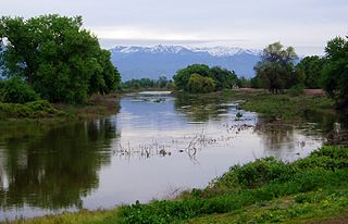
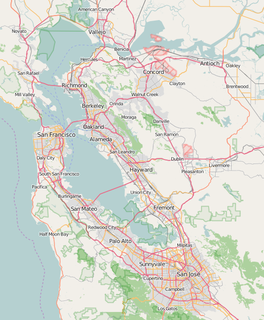
The Sacramento–San Joaquin River Delta, or California Delta, is an expansive inland river delta and estuary in Northern California. The Delta is formed at the western edge of the Central Valley by the confluence of the Sacramento and San Joaquin rivers and lies just east of where the rivers enter Suisun Bay. The Delta is recognized for protection by the California Bays and Estuaries Policy. The city of Stockton is located on the San Joaquin River on the eastern edge of the delta. The total area of the Delta, including both land and water, is about 1,100 square miles (2,800 km2).

Broderick is a former town in Yolo County, California, United States, now forming part of the City of West Sacramento. It is located just west of the Sacramento River in the eastern portion of the county. Broderick's ZIP Code is 95605 and its area code 916. It lies at an elevation of 23 feet.
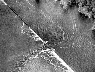
A levee breach or levee failure is a situation where a levee fails or is intentionally breached, causing the previously contained water to flood the land behind the levee.

On August 29, 2005, there were over 50 failures of the levees and flood walls protecting New Orleans, Louisiana, and its suburbs following passage of Hurricane Katrina and landfall in Mississippi. The levee and flood wall failures caused flooding in 80% of New Orleans and all of St. Bernard Parish. Tens of billions of gallons of water spilled into vast areas of New Orleans, flooding over 100,000 homes and businesses. Responsibility for the design and construction of the levee system belongs to the United States Army Corps of Engineers; the responsibility of maintenance belongs to the local levee boards. The Corps hands components of the system over to the local levee boards upon completion. When Katrina struck in 2005, the project was between 60–90% complete. Four major investigations were conducted by civil engineers and other experts in an attempt to identify the underlying reasons for the failure of the federal flood protection system. All concur that the primary cause of the flooding was inadequate design and construction by the Corps of Engineers.

Mill Creek is a 17.8-mile-long (28.6 km) stream, originating in the San Bernardino Mountains, in San Bernardino County, California. It is a major tributary of the Santa Ana River. Their confluence occurs just downstream of the upper Santa Ana Canyon mouth. Part of the upper creek flows through San Bernardino National Forest, with the headwaters, being in the San Gorgonio Wilderness.
Aera Energy LLC (Aera) is a natural gas, oil exploration and production company jointly owned by Shell Oil Company and ExxonMobil headquartered in Bakersfield, California. In addition, Aera Energy LLC is a California limited liability company, and one of California’s largest oil and natural gas producers, with an approximate 2015 revenues of over $2 billion. Aera is operated as a stand-alone company through its board of managers.1

San Juan Creek, also called the San Juan River, is a 29-mile (47 km) long stream in Orange County, California draining a watershed of 133.9 square miles (347 km2). Its mainstem begins in the southern Santa Ana Mountains in the Cleveland National Forest. It winds west and south through San Juan Canyon, and is joined by Arroyo Trabuco as it passes through San Juan Capistrano. It flows into the Pacific Ocean at Doheny State Beach. San Juan Canyon provides a major part of the route for California State Route 74.

Pescadero Creek is a major stream in Santa Cruz and San Mateo counties in California. At 26.6 miles (42.8 km), it is the longest stream in San Mateo County and flows all year from springs in the Santa Cruz Mountains. Its source is at 1,880 feet (570 m) above sea level on the western edge of Castle Rock State Park, with additional headwaters in Portola Redwoods State Park, and its course traverses Pescadero Creek County Park and San Mateo County Memorial Park before entering Pescadero Marsh Natural Preserve at Pescadero State Beach and thence to the Pacific Ocean 14.4 miles (23 km) south of Half Moon Bay.
Fresno City is a former settlement in Fresno County, California. It was located at the head of navigation on Fresno Slough 2 miles (3.2 km) northwest of Tranquillity, at an elevation of 164 feet. The city was named after the Spanish word for the Oregon Ash trees that commonly grew along the river banks.
Bethel Island is an island in the Sacramento-San Joaquin River Delta of Contra Costa County, California, approximately 10 kilometres (6.2 mi) east of Antioch. The island describes itself as "the heart of the California Delta." The population at the 2010 census was 2,137, a 7.6 percent decline from 2,312 at the 2000 census.
The Jones Tract is an island containing Lower Jones Tract and the Upper Jones Tract in the Sacramento-San Joaquin River Delta in San Joaquin County, California, fifteen kilometres west of Stockton. The 4,900 ha island is bounded on the north by Empire Cut, on the northeast by Whiskey Slough, on the southeast by Trapper Slough, and on the west, Middle River. The tracts are bifurcated by the parallel running Mokelumne Aqueduct, West Lower Jones Road, and a railroad originally built by the Achison Topeka and Santa Fe Railroad, which now carries freight trains of the BNSF Railway and Amtrak California's San Joaquin.
Kings Island is an island in the Old River (California) in the south Sacramento-San Joaquin River Delta in San Joaquin County, California, fifteen kilometres southwest of Stockton. The small 3.5 ha (8.6-acre) island is the smallest of a cluster of delta islands including Eucalyptus Island, Widdows Island, Victoria Island (California), and Coney Island, adjacent to Clifton Court Forebay. At 1 metre below sea level with the surrounding waters kept a bay by a levee system, the island is accessible only by the one road from the Clifton Court levee or by boat.

Mound Landing is a ghost town in Bolivar County, Mississippi, United States.
Greco Island is a wetland in Redwood City, California. Greco Island is part of the larger Don Edwards San Francisco Bay National Wildlife Refuge. Westpoint Slough follows the South side of the island while Redwood Creek is along the West. The San Francisco Bay bounds the North and East sides of the island.


