
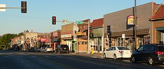
The Dundee–Happy Hollow Historic District is located west of Midtown Omaha, Nebraska. It covers the area between Harney Street on the south, Hamilton Street on the north, Happy Hollow Boulevard on the west, and 46th Street on the east. The "heart" of Dundee is located at 50th and Underwood Avenue in Omaha, Nebraska, United States. It was founded in 1880 and annexed into the city in 1915. Dundee is home to Warren Buffett and nationally syndicated editorial cartoonist Jeff Koterba and was the hometown of filmmaker Alexander Payne. Actor Henry Fonda additionally lived in the Dundee neighborhood.
Benson is a historic neighborhood in Omaha, Nebraska. Now a pocket within North Omaha, Benson Place was originally platted in 1887 and was annexed into the City of Omaha in 1917. Actor Nick Nolte lived in the Benson area before moving to the Westside district.

North Omaha is a community area in Omaha, Nebraska, in the United States. It is bordered by Cuming and Dodge Streets on the south, Interstate 680 on the north, North 72nd Street on the west and the Missouri River and Carter Lake, Iowa on the east, as defined by the University of Nebraska at Omaha and the Omaha Chamber of Commerce.
North Omaha, Nebraska has a recorded history spanning over 200 years, pre-dating the rest of Omaha, encompassing wildcat banks, ethnic enclaves, race riots and social change. North Omaha has roots back to 1812 and the founding of Fort Lisa. It includes the Mormon settlement of Cutler's Park and Winter Quarters in 1846, a lynching before the turn of the twentieth century, the thriving 24th Street community of the 1920s, the bustling development of its African-American community through the 1950s, a series of riots in the 1960s, and redevelopment in the late 20th and early 21st century.
Saratoga Springs, Nebraska Territory, or Saratoga, was a boom and bust town founded in 1856 that thrived for several years. During its short period of influence the town grew quickly, outpacing other local settlements in the area including Omaha and Florence, and briefly considered as a candidate for the Nebraska Territorial capitol. Saratoga was annexed into Omaha in 1887, and has been regarded a neighborhood in North Omaha since then.

Fort Omaha, originally known as Sherman Barracks and then Omaha Barracks, is an Indian War-era United States Army supply installation. Located at 5730 North 30th Street, with the entrance at North 30th and Fort Streets in modern-day North Omaha, Nebraska, the facility is primarily occupied by Metropolitan Community College. A Navy Operational Support Center and Marine Corps Reserve unit, along with an Army Reserve unit occupy the periphery of the 82.5 acres (33.4 ha) fort. The government deeded all but four parcels of the land to Metropolitan Community College in 1974.

The history of Omaha, Nebraska, began before the settlement of the city, with speculators from neighboring Council Bluffs, Iowa staking land across the Missouri River illegally as early as the 1840s. When it was legal to claim land in Indian Country, William D. Brown was operating the Lone Tree Ferry to bring settlers from Council Bluffs to Omaha. A treaty with the Omaha Tribe allowed the creation of the Nebraska Territory, and Omaha City was founded on July 4, 1854. With early settlement came claim jumpers and squatters, and the formation of a vigilante law group called the Omaha Claim Club, which was one of many claim clubs across the Midwest. During this period many of the city's founding fathers received lots in Scriptown, which was made possible by the actions of the Omaha Claim Club. The club's violent actions were challenged successfully in a case ultimately decided by the U.S. Supreme Court, Baker v. Morton, which led to the end of the organization.
The neighborhoods of Omaha are a diverse collection of community areas and specific enclaves. They are spread throughout the Omaha metro area, and are all on the Nebraska side of the Missouri River.

The Jewell Building is a city landmark in North Omaha, Nebraska. Built in 1923, it is listed on the National Register of Historic Places. Located at 2221 North 24th Street, the building was home to the Dreamland Ballroom for more than 40 years, and featured performances by many touring jazz and blues legends, including Duke Ellington, Count Basie, Louis Armstrong, Dizzy Gillespie, and Lionel Hampton.

The Bemis Park Landmark Heritage District is located in North Omaha, Nebraska. Situated from Cuming Street to Hawthorne Avenue, Glenwood Avenue to 33rd Street, Bemis Park was annexed into Omaha in 1887, and developed from 1889-1922. The district was designated an Omaha Landmark in 1983.
The Kountze Place neighborhood of Omaha, Nebraska is a historically significant community on the city's north end. Today the neighborhood is home to several buildings and homes listed on the National Register of Historic Places. It is located between North 16th Avenue on the east to North 30th Street on the west; Locust Street on the south to Pratt Street on the north. Kountze Place was annexed into Omaha in 1887. The neighborhood was built as a suburban middle and upper middle class enclave for doctors, lawyers, successful businessmen and other professional workers.

The Sherman is a historically significant apartment building located at 2501 North 16th Street in the Near North Side of Omaha, Nebraska. Built in 1897, it was designated an Omaha landmark in 1985; in 1986 it was listed on the National Register of Historic Places.

Downtown Omaha is the central business, government and social core of the Omaha-Council Bluffs metropolitan area, U.S. state of Nebraska. The boundaries are Omaha's 20th Street on the west to the Missouri River on the east and the centerline of Leavenworth Street on the south to the centerline of Chicago Street on the north, also including the CHI Health Center Omaha. Downtown sits on the Missouri River, with commanding views from the tallest skyscrapers.
Florence Boulevard, originally known as the Prettiest Mile in Omaha Boulevard, is a boulevard-type north-south street in the north Omaha, Nebraska. With the start of construction in 1892, Florence Boulevard was the first roadway in Omaha's boulevard system designed by Horace Cleveland. Florence Boulevard was the first roadway in Omaha to be fully lit with electric lamps.

The Lincoln Highway in Omaha, Nebraska, runs east–west from near North 183rd Street and West Dodge Road in Omaha, Nebraska, towards North 192nd Street outside of Elkhorn. This section of the Lincoln Highway, one of only 20 miles (32 km) that were paved with brick in Nebraska, is one of the most well-preserved in the country. The roadway was listed on the National Register of Historic Places in 1984. The Lincoln Highway was the first road across the United States, traversing coast-to-coast from Times Square in New York City to Lincoln Park in San Francisco, California.

Transportation in Omaha, Nebraska, includes most major modes, such as pedestrian, bicycle, automobile, bus, train and airplane. While early transportation consisted of ferries, stagecoaches, steamboats, street railroads, and railroads, the city's transportation systems have evolved to include the Interstate Highway System, parklike boulevards and a variety of bicycle and pedestrian trails. The historic head of several important emigrant trails and the First Transcontinental Railroad, its center as a national transportation hub earned Omaha the nickname "Gate City of the West" as early as the 1860s.
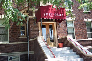
The Ford Hospital, also called the Fifth Avenue Hotel, is located in Midtown Omaha, Nebraska. Built in 1916 by Home Builders Incorporated, the hospital was a privately operated facility built and operated by Dr. Michael J. Ford. Operating until 1922, it was the last small, private hospital in the city. Originally designed by James T. Allan, the building stylistically is a unique blend of elements from the Second Renaissance Revival and the Arts and Crafts movements. The building was sold and remodeled as the Fifth Avenue Hotel in 1929, a name referring to the nickname Douglas Street obtained after the installation of new electric lights in 1927. The building was again converted in 1987, and currently serves as apartments.
Dodge Street is the main east–west street in Omaha, Nebraska. Numbered as U.S. Route 6 (US 6), the street starts in Downtown Omaha and connects to West Dodge Road just west of 78th Street. From there, it continues westward through the remainder of Douglas County.
North 30th Street is a two-way street that runs south–north in the North Omaha area of Omaha, Nebraska. With the street beginning at Dodge Street, historically significant sections include those from Dodge to Lake Street, from Fort Street to Laurel Avenue, and from Weber to Bondesson Streets.


