
Maligne Lake is a lake in Jasper National Park, Alberta, Canada. The lake is famed for the colour of its azure water, the surrounding peaks, the three glaciers visible from the lake, and Spirit Island, a frequently and very famously photographed islet. The lake is located 44 km (27 mi) south of Jasper town, and is accessible by motor vehicle, including shuttle buses from Jasper. Boat tours run to Spirit Island in the spring to autumn season. The 44 km Skyline Trail, Jasper's most popular, highest and above treeline, multi-day hike, begins at Maligne Lake and finishes near the town of Jasper. Other popular day hikes include the Opal Hills and Bald Hills loops. Winter activities include cross-country skiing and snowboarding.

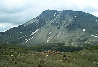
Mount Hector is a 3,394-metre (11,135-foot) mountain summit located in the Bow River valley of Banff National Park, in the Canadian Rockies of Alberta, Canada. The mountain was named in 1884 by George M. Dawson after James Hector, a geologist on the Palliser expedition. The mountain is located beside the Icefields Parkway, 17 km (11 mi) north of Lake Louise.

Mount Julian is a peak located at the southern end of Maligne Lake in Jasper National Park, Alberta, Canada.

Mount Unwin is a 3,268-metre (10,722-foot) mountain summit located on the west side of Maligne Lake in Jasper National Park, in the Queen Elizabeth Range of the Canadian Rockies of Alberta, Canada. Its nearest higher peak is Mount Brazeau, 13.0 km (8.1 mi) to the east-southeast.

Mount Kerkeslin is a 2,984 m (9,790 ft) mountain summit located in the Athabasca River valley of Jasper National Park, in the Canadian Rockies of Alberta, Canada. It is the highest peak of the Maligne Range. It is located in the south part of the Maligne Range, east of the Icefields Parkway and is visible from the Athabasca Falls lookout. Mount Kerkeslin is composed of sedimentary rock laid down during the Cambrian period and pushed east and over the top of younger rock during the Laramide orogeny.
Amber Mountain is a 2,565-metre (8,415-foot) mountain summit located in the Maligne Range of Jasper National Park, in the Canadian Rockies of Alberta, Canada. Amber Mountain was so named on account of amber-hued shale outcroppings. The mountain was named in 1916 by Morrison P. Bridgland (1878-1948), a Dominion Land Surveyor who named many peaks in Jasper Park and the Canadian Rockies. The mountain's name was officially adopted in 1947 when approved by the Geographical Names Board of Canada. Its nearest higher peak is The Watchtower, 5.0 km (3.1 mi) to the east. Amber Mountain is composed of sedimentary rock laid down during the Cambrian period and pushed east and over the top of younger rock during the Laramide orogeny.
Curator Mountain is a 2,624-metre (8,609-foot) mountain summit located in the Maligne Range of Jasper National Park, in the Canadian Rockies of Alberta, Canada. Curator Mountain was so named on account of its central location, as if it were the "custodian" of Shovel Pass. The mountain was named in 1916 by Morrison P. Bridgland (1878-1948), a Dominion Land Surveyor who named many peaks in Jasper Park and the Canadian Rockies. The mountain's name was officially adopted in 1947 when approved by the Geographical Names Board of Canada. Its nearest higher peak is Trowel Peak, 7.7 km (4.8 mi) to the southeast. Curator Mountain is composed of sedimentary rock laid down during the Cambrian period and pushed east and over the top of younger rock during the Laramide orogeny.

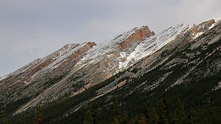
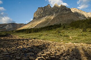
Grisette Mountain is a 2,620-metre (8,600 ft) mountain summit located in Jasper National Park in Alberta, Canada. It is located in the Colin Range, which is a sub-range of the Canadian Rockies. The peak is situated 14 km (8.7 mi) northeast of the municipality of Jasper, and is a prominent landmark in the Athabasca Valley visible from Highway 16 and the Canadian. Its nearest higher peak is Mount Dromore, 2.4 km (1.5 mi) to the east.

Samson Peak is a 3,081-metre (10,108 ft) mountain summit located on the eastern shore of Maligne Lake in Jasper National Park, in the Canadian Rockies of Alberta, Canada. The nearest higher peak is Mount Charlton, 7.26 km (4.51 mi) to the east. Samson Peak is situated 1.72 km south of Leah Peak in the Queen Elizabeth Ranges.
Leah Peak is a 2,801-metre (9,190 ft) mountain summit located on the eastern shore of Maligne Lake in Jasper National Park, in the Canadian Rockies of Alberta, Canada. The nearest higher peak is Samson Peak, 1.72 km (1.07 mi) to the north.

Monkhead is a 3,250-metre (10,660-foot) mountain summit located at the south end of Maligne Lake in Jasper National Park, in the Canadian Rockies of Alberta, Canada. Monkhead was named by the Alpine Club of Canada for its hood-like appearance similar to a monk. Its nearest higher peak is Mount Warren, 2.3 kilometres to the south-southeast.
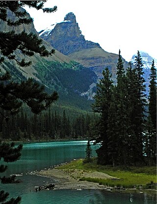
Mount Paul is a 2,850-metre (9,350 ft) mountain summit towering 1134 metres above the east shore of Maligne Lake in Jasper National Park, in the Canadian Rockies of Alberta, Canada. The nearest higher peak is Maligne Mountain, 1.81 km (1.12 mi) to the north-northwest. Mount Paul is situated north of Monkhead and they are often seen together in the background of iconic calendar photos of Spirit Island and Maligne Lake.

Mount Hardisty is a 2,716 m (8,911 ft) mountain summit located in the Athabasca River valley of Jasper National Park, in the Canadian Rockies of Alberta, Canada. Its nearest higher peak is Mount Kerkeslin, 6.0 km (3.7 mi) to the south. Both mountains are part of the Maligne Range and are visible from the Icefields Parkway.
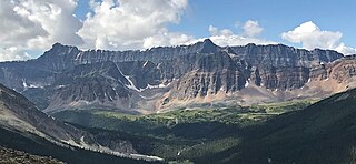
Endless Chain Ridge is a 16-kilometre-long (9.9-mile), 2,867-metre-high (9,406-foot), mountainous ridge located in Jasper National Park, in the Canadian Rockies of Alberta, Canada. The ridge is situated at the southern end of the Maligne Range, and east of the confluence of the Sunwapta River with the Athabasca River. Seen from the Icefields Parkway, the ridge is relatively unimpressive, but from the east side it appears as a rugged chain of peaks, all quite difficult to climb.
Mount Tekarra is a 2,694-metre (8,839-foot) mountain summit located in the Athabasca River valley of Jasper National Park, in the Canadian Rockies of Alberta, Canada. It is situated at the northwest end of the Maligne Range and is visible from Jasper and the Icefields Parkway. The nearest higher neighbor is The Watchtower, 7.0 km (4.3 mi) to the east.
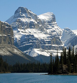
Mount Warren is a 3,362-metre (11,030-foot) mountain summit located at the southeast end of Maligne Lake in Jasper National Park, in the Canadian Rockies of Alberta, Canada. Mount Warren is often seen in the background of iconic calendar photos of Spirit Island and Maligne Lake. The mountain rises 1,690 metres (5,540 ft) in less than 4 kilometres (2.5 mi) from the lake giving it dramatic local relief. Mount Warren is situated at the northwest edge of the Brazeau Icefield, and its nearest higher peak is Mount Brazeau, 2.26 kilometres to the southeast. Monkhead is a lower secondary summit to the northwest of the true summit.

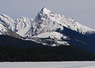
Maligne Mountain is a 3,200-metre (10,500-foot) multi-peak massif located east of Maligne Lake in Jasper National Park, in the Canadian Rockies of Alberta, Canada. Maligne Mountain is surrounded by glaciers, and its nearest higher peak is Monkhead, 7.8 km (4.8 mi) to the south.

Opal Peak is a 2,840-metre (9,320-foot) mountain summit located northeast of the northern end of Maligne Lake in Jasper National Park, in the Canadian Rockies of Alberta, Canada. It is situated in the Opal Hills, west of Opal Lake and 5.44 km (3.38 mi) northwest of Leah Peak.

The Watchtower is a 2,791-metre (9,157 ft) mountain summit located in the Maligne River valley of Jasper National Park, in the Canadian Rockies of Alberta, Canada. It is situated in the Maligne Range and is visible from the Maligne Lake Road where it towers over Medicine Lake. Its nearest higher peak is Sirdar Mountain, 11.64 km (7.23 mi) to the north.
Evelyn Peak is a 2,855 m (9,367 ft) mountain summit in the Athabasca River valley of Jasper National Park, in the Canadian Rockies of Alberta, Canada. THe nearest higher peak is Mount Kerkeslin, 5.0 km (3.1 mi) to the southwest, and Mount Hardisty is 6.0 km (3.7 mi) to the northwest. All three are part of the Maligne Range. Evelyn Peak is composed of sedimentary rock laid down during the Cambrian period and pushed east and over the top of younger rock during the Laramide orogeny. The mountain is at the headwaters of Evelyn Creek, and three kilometres south of Evelyn Pass. The creek and pass were named in 1921 for Evelyn Cavendish, Duchess of Devonshire (1870–1960), who visited nearby Maligne Lake in 1920. The mountain's name however, has not yet been officially adopted by the Geographical Names Board of Canada.


