Mount Tyrwhitt

Last updated
Mount Tyrwhitt
Mounttyrwhitt.JPG
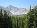
Mount Tyrwhitt's north face with Grizzly col to the left
Highest point
Elevation 2,874 m (9,429 ft) [1] [2] [3]
Prominence 216 m (709 ft) [4]
Parent peak Mount Pocaterra (2941 m) [4]
Listing
Coordinates 50°34′56″N115°00′58″W / 50.58222°N 115.01611°W / 50.58222; -115.01611 [5]
Geography
Canada British Columbia relief location map.jpg
Red triangle with thick white border.svg
Mount Tyrwhitt
Location in eastern British Columbia
Canada Alberta relief location map - transverse mercator proj.svg
Red triangle with thick white border.svg
Mount Tyrwhitt
Mount Tyrwhitt (Alberta)
Country Canada
Provinces Alberta and British Columbia
District Kootenay Land District [5]
Parent range Elk Range
Topo map NTS   82J11 Kananaskis Lakes [5]
Climbing
First ascent 1915 by the Interprovincial Boundary Commission [4]
Easiest route Scramble (Moderate) [3]

Mount Tyrwhitt is a mountain in British Columbia and Alberta, Canada located between Highway 40 and Elk Pass in the Elk Range of the Canadian Rockies, west of the Highwood Pass parking lot in Kananaskis Country and south east of Upper Kananaskis Lake. Located on the Continental Divide, it is also therefore on the border between British Columbia and Alberta which follows the Divide in this area.

Contents

The mountain was named in 1918 after First Admiral Reginald Tyrwhitt, a senior officer in the Royal Navy during the First World War. [5]

See also

Related Research Articles

<span class="mw-page-title-main">Banff National Park</span> National park in Alberta, Canada

Banff National Park is Canada's oldest national park, established in 1885 as Rocky Mountains Park. Located in Alberta's Rocky Mountains, 110–180 kilometres (68–112 mi) west of Calgary, Banff encompasses 6,641 square kilometres (2,564 sq mi) of mountainous terrain, with many glaciers and ice fields, dense coniferous forest, and alpine landscapes. The Icefields Parkway extends from Lake Louise, connecting to Jasper National Park in the north. Provincial forests and Yoho National Park are neighbours to the west, while Kootenay National Park is located to the south and Kananaskis Country to the southeast. The main commercial centre of the park is the town of Banff, in the Bow River valley.

<span class="mw-page-title-main">Elk Range (Canada)</span> Mountain range in British Columbia and Alberta, Canada

The Elk Range is a mountain range of the Canadian Rockies, located on the southern edge of Kananaskis on the Alberta-British Columbia border. The range was named for elk found on the mountain slopes and in the nearby Elk River valley. Originally known as the Elk Mountains in 1917, the name was formally changed to the Elk Range in 1951.

<span class="mw-page-title-main">Bow Valley Provincial Park</span> Provincial park in Alberta, Canada

Bow Valley Provincial Park is a provincial park in Alberta, Canada. Established in 1959 in the arch of the Bow River at its confluence with the Kananaskis River, the park is one park of many within the Kananaskis Country park system.

<span class="mw-page-title-main">Peter Lougheed Provincial Park</span> Provincial park in Alberta, Canada

Peter Lougheed Provincial Park is in Kananaskis Country about 90 kilometres (56 mi) west of Calgary, along the Kananaskis Trail in Alberta, Canada.

Height of the Rockies Provincial Park is a provincial park in the Canadian Rockies of south eastern British Columbia, Canada. It is located west of the Continental Divide, adjacent to Elk Lakes Provincial Park.

The Elk Lakes cabin is an alpine hut located between the French and Italian Military Groups in the Canadian Rockies. It resides near the Continental Divide in Elk Lakes Provincial Park, British Columbia. It is 62 km south of the Trans-Canada Highway in Kananaskis Country, Alberta and 104 km north of Sparwood, British Columbia. The area has hiking trails, and provides access to mountaineering objectives. In winter, ice climbs and skiing terrain with much powder abound. Elk Lakes terrain is similar to that near the Elizabeth Parker hut. The hut is maintained by the Alpine Club of Canada.

<span class="mw-page-title-main">Great Divide Trail</span> A long-distance hiking trail

The Great Divide Trail (GDT) is a wilderness hiking trail in the Canadian Rockies. The trail closely follows the Great Divide between Alberta and British Columbia, crossing the divide more than 30 times. Its southern terminus is in Waterton Lakes National Park at the Canada–US border and its northern terminus is at Kakwa Lake in Kakwa Provincial Park, north of Jasper National Park. The trail is 1,130 km (700 mi) long and ranges in elevation from 1,055 m (3,461 ft) at Old Fort Point trailhead near Jasper to 2,590 m (8,500 ft) at an unnamed pass above Michele Lakes just south of the White Goat Wilderness Area.

<span class="mw-page-title-main">Ranges of the Canadian Rockies</span>

The Canadian Rockies are a segment of the North American Rocky Mountains found in the Canadian provinces of Alberta and British Columbia.

<span class="mw-page-title-main">Upper Kananaskis Lake</span> Reservoir in Kananaskis, Alberta

Upper Kananaskis Lake is a natural lake that was turned into a reservoir in Kananaskis Country in Alberta, Canada.

<span class="mw-page-title-main">Alberta's Rockies</span> Rocky Mountains in Alberta, Canada

Alberta's Rockies comprise the Canadian Rocky Mountains in Alberta, Canada. On the southwestern part of the province along the British Columbia border, the region covers all but the south of Census Division 15.

<span class="mw-page-title-main">Mount Allen (Canada)</span> Mountain in Canada

Mount Allen is a mountain in the Canadian Rockies, on the Continental Divide, which forms the provincial boundary between British Columbia and Alberta in this region. J. Monroe Thorington named this mountain for Samuel Evans Stokes Allen in 1924. Allen was an American cartographer who mapped this area of the Rockies in 1894-95. Allen had named this mountain "Shappee", the Stoney language word for "six", as part of his naming of the ten mountains in the Valley of the Ten Peaks. The peak forms part of the backdrop to Moraine Lake in Banff National Park.

<span class="mw-page-title-main">Mount Pocaterra</span> Mountain in the country of Canada

Mount Pocaterra is the unofficial name of a rocky formation named after the Pocaterra Creek in the same region. It is located in the Elk Range in Alberta. This peak is located on the crest of a ridge, about 1.5 km north of the lower Mount Tyrwhitt. The peak is a double summit, with the north summit slightly higher.

Elk Pass is a high mountain pass in the Canadian Rockies, traversing the continental divide. It connects the Elk Valley in the province of British Columbia with the Kananaskis Valley in Alberta.

<span class="mw-page-title-main">Mount Robertson</span> Mountain in the country of Canada

Mount Robertson is a mountain in the Canadian Rockies, standing astride the British Columbia-Alberta boundary between Palliser Pass and North Kananaskis Pass. The British Columbia side of the pass is in Mount Assiniboine Provincial Park. The mountain is named for Sir William Robertson (1860–1933), 1st Baronet, Chief of the Imperial General Staff from 1916 to 1918 during the First World War.

<span class="mw-page-title-main">Mount Beatty</span> Mountain in the country of Canada

Mount Beatty is a mountain located on the border of Alberta and British Columbia on the Continental Divide. It was named in 1924 after David Beatty, a British naval officer of Irish ancestry who commanded ships in the First World War.

Mount Cordonnier is located on the border of Alberta and British Columbia on the Continental Divide. It was named in 1918 after General Victor Louis Emilien Cordonnier.

A mountain formerly known as Mount Pétain, but with no current official name, is located on the border of the Canadian provinces of Alberta and British Columbia (BC) on the Continental Divide.

<span class="mw-page-title-main">Mount Fox (Canadian Rockies)</span> Mountain in the country of Canada

Mount Fox is a 2,973-metre (9,754-foot) mountain on the shared border between Alberta and British Columbia, Canada. It is situated on the Continental Divide south of the Kananaskis Lakes area of the Canadian Rockies. It was named in 1859 by John Palliser after Sir Charles Fox (1810-1874), a member of the Royal Geographical Society.

<span class="mw-page-title-main">Mount Sarrail</span> Mountain in the country of Canada

Mount Sarrail is a 3,159-metre (10,364-foot) mountain summit located in Kananaskis Country in the Canadian Rockies of Alberta, Canada. Mount Sarrail is situated 1.0 kilometre north of the Continental Divide, within Peter Lougheed Provincial Park. Its nearest higher peak is Mount Foch, 1.0 km (0.62 mi) to the southeast. Mount Sarrail can be seen from Upper Kananaskis Lake and Alberta Highway 40.

References

  1. Kananaskis Lakes (Map). 1:50,000. Cochrane, AB: Gem Trek Publishing. 1998. § D5. ISBN   1-895526-24-8 . Retrieved 2021-07-16.
  2. "Mount Tyrwhitt". cdnrockiesdatabases.ca. Retrieved 2019-08-20.
  3. 1 2 Kane, Alan (2016). "Mount Tyrwhitt". Scrambles in the Canadian Rockies (3rd ed.). Calgary: Rocky Mountain Books. Kindle Edition. ISBN   978-1-77160-098-9.
  4. 1 2 3 "Mount Tyrwhitt". Bivouac.com. Retrieved 2009-01-02.
  5. 1 2 3 4 "Mount Tyrwhitt". BC Geographical Names . Retrieved 2013-06-12.