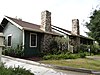
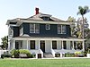
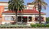
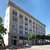
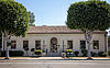
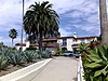
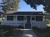
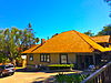
[3] Name on the Register [4] Image Date listed [5] Location City or town Description 1 Lewis Ainsworth House Lewis Ainsworth House March 13, 1981 (# 81000163 414 E. Chapman Ave. 33°47′17″N 117°50′56″W / 33.788056°N 117.848889°W / 33.788056; -117.848889 (Lewis Ainsworth House ) Orange 2 Anaheim Orange and Lemon Association Packing House Anaheim Orange and Lemon Association Packing House July 7, 2015 (# 15000379 440 S. Anaheim Blvd. 33°49′53″N 117°54′44″W / 33.8314°N 117.9121°W / 33.8314; -117.9121 (Anaheim Orange and Lemon Association Packing House ) Anaheim 3 Artz Building Artz Building April 18, 1994 (# 94000364 150-158 W. Main St. 33°44′29″N 117°49′43″W / 33.741389°N 117.828611°W / 33.741389; -117.828611 (Artz Building ) Tustin 4 Ferdinand Backs House Ferdinand Backs House October 14, 1980 (# 80000826 225 N. Claudina St. 33°50′15″N 117°54′46″W / 33.8375°N 117.912778°W / 33.8375; -117.912778 (Ferdinand Backs House ) Anaheim 5 Balboa Inn Balboa Inn April 11, 1986 (# 86000730 105 Main St. 33°36′05″N 117°53′56″W / 33.601389°N 117.898889°W / 33.601389; -117.898889 (Balboa Inn ) Newport Beach 6 Balboa Pavilion Balboa Pavilion May 17, 1984 (# 84000914 400 Main St. 33°36′10″N 117°53′52″W / 33.602778°N 117.897778°W / 33.602778; -117.897778 (Balboa Pavilion ) Newport Beach 7 Bank of Balboa-Bank of America Upload image July 24, 1986 (# 86001903 611 E. Balboa Blvd. 33°36′07″N 117°53′59″W / 33.601944°N 117.899722°W / 33.601944; -117.899722 (Bank of Balboa-Bank of America ) Newport Beach demolished [6] 8 Beckman Instruments Inc. Administration Building Upload image January 31, 2017 (# 100000620 4300 N. Harbor Blvd. 33°55′22″N 117°55′57″W / 33.922730°N 117.932565°W / 33.922730; -117.932565 (Beckman Instruments Inc. Administration Building ) Fullerton demolished 9 Bixby-Bryant Ranch House Bixby-Bryant Ranch House January 16, 1997 (# 96001537 5700 Susanna Bryant Dr. 33°52′30″N 117°42′28″W / 33.875°N 117.707778°W / 33.875; -117.707778 (Bixby-Bryant Ranch House ) Yorba Linda 10 A. S. Bradford House A. S. Bradford House October 3, 1978 (# 78000730 136 Palm Circle 33°53′18″N 117°51′49″W / 33.888333°N 117.863611°W / 33.888333; -117.863611 (A. S. Bradford House ) Placentia 11 Brea City Hall and Park Brea City Hall and Park May 24, 1984 (# 84000917 401 S. Brea Blvd. 33°54′51″N 117°54′05″W / 33.914167°N 117.901389°W / 33.914167; -117.901389 (Brea City Hall and Park ) Brea 12 Builders Exchange Building Builders Exchange Building April 29, 1982 (# 82002223 202-208 N. Main St. 33°44′47″N 117°52′01″W / 33.746389°N 117.866944°W / 33.746389; -117.866944 (Builders Exchange Building ) Santa Ana 13 Carnegie Library Carnegie Library October 22, 1979 (# 79000511 241 S. Anaheim Blvd. 33°50′00″N 117°54′45″W / 33.833333°N 117.9125°W / 33.833333; -117.9125 (Carnegie Library ) Anaheim 14 Casa de Esperanza Casa de Esperanza October 1, 1990 (# 90001484 31806 El Camino Real 33°30′04″N 117°39′38″W / 33.501111°N 117.660556°W / 33.501111; -117.660556 (Casa de Esperanza ) San Juan Capistrano 15 Casa Romantica Casa Romantica December 27, 1991 (# 91001900 415 Avenida Granada 33°25′16″N 117°37′13″W / 33.421111°N 117.620278°W / 33.421111; -117.620278 (Casa Romantica ) San Clemente 16 Chapman Building Chapman Building September 22, 1983 (# 83001212 110 E. Wilshire Ave. 33°52′20″N 117°55′23″W / 33.872222°N 117.923056°W / 33.872222; -117.923056 (Chapman Building ) Fullerton 17 Christ College Site Upload image April 16, 1993 (# 93000300 Northeastern corner of the Concordia University (formerly Christ College, from which the name is derived) campus, off University Dr. [7] 33°39′24″N 117°48′27″W / 33.656667°N 117.8075°W / 33.656667; -117.8075 (Christ College Site ) Irvine 18 Dr. George C. Clark House Dr. George C. Clark House December 12, 1976 (# 76000506 California State University campus 33°53′14″N 117°52′59″W / 33.887222°N 117.883056°W / 33.887222; -117.883056 (Dr. George C. Clark House ) Fullerton 19 Joel R. Congdon House Joel R. Congdon House July 22, 2002 (# 02000801 32701 Alipaz St. 33°29′19″N 117°40′23″W / 33.488611°N 117.673056°W / 33.488611; -117.673056 (Joel R. Congdon House ) San Juan Capistrano Home to The Ecology Center . 20 Consolidated Orange Growers Precooling & Ice Plant Consolidated Orange Growers Precooling & Ice Plant September 20, 2021 (# 100006912 160 South Cypress St. 33°47′12″N 117°51′23″W / 33.7868°N 117.8564°W / 33.7868; -117.8564 (Consolidated Orange Growers Precooling & Ice Plant ) Orange 21 Crystal Cove Historic District Crystal Cove Historic District June 15, 1979 (# 79000514 Northwest of Laguna Beach 33°34′29″N 117°50′26″W / 33.574722°N 117.840556°W / 33.574722; -117.840556 (Crystal Cove Historic District ) Laguna Beach 22 C. Z. Culver House C. Z. Culver House March 20, 1986 (# 86000458 205 E. Palmyra 33°47′04″N 117°51′03″W / 33.784444°N 117.850833°W / 33.784444; -117.850833 (C. Z. Culver House ) Orange 23 Cypress Street Schoolhouse Cypress Street Schoolhouse July 7, 2015 (# 15000380 544 N. Cypress St. 33°47′47″N 117°51′23″W / 33.7964°N 117.8565°W / 33.7964; -117.8565 (Cypress Street Schoolhouse ) Orange 24 Dewella Apartments Dewella Apartments February 2, 2009 (# 08001406 234-236 E. Wilshire Ave. 33°52′21″N 117°55′14″W / 33.872386°N 117.920475°W / 33.872386; -117.920475 (Dewella Apartments ) Fullerton 25 Downtown Santa Ana Historic Districts (North, Government/Institutional and South, Retail) Downtown Santa Ana Historic Districts (North, Government/Institutional and South, Retail) December 19, 1984 (# 84000438 Roughly bounded by Civic Center Dr., First, Ross, and Spurgeon Sts. 33°44′54″N 117°52′05″W / 33.748333°N 117.868056°W / 33.748333; -117.868056 (Downtown Santa Ana Historic Districts (North, Government/Institutional and South, Retail) ) Santa Ana 26 Oscar Easley Block Oscar Easley Block February 17, 1983 (# 83001213 101 El Camino Real 33°25′40″N 117°36′42″W / 33.427778°N 117.611667°W / 33.427778; -117.611667 (Oscar Easley Block ) San Clemente 27 Ebell Society of Santa Ana Valley Ebell Society of Santa Ana Valley July 2, 2001 (# 01000682 625 N. French St. 33°45′03″N 117°51′49″W / 33.750833°N 117.863611°W / 33.750833; -117.863611 (Ebell Society of Santa Ana Valley ) Santa Ana 28 Richard Egan House Richard Egan House January 17, 2017 (# 100000460 31829 Camino Capistrano 33°30′02″N 117°39′45″W / 33.500551°N 117.662622°W / 33.500551; -117.662622 (Richard Egan House ) San Juan Capistrano 29 Electra (motor yacht) Upload image May 1, 2023 (# 100008894 Huntington Harbor at 16591 Ensign Ct. 33°43′16″N 118°03′37″W / 33.7210°N 118.0604°W / 33.7210; -118.0604 (Electra (motor yacht) Huntington Beach 30 Elephant Packing House Elephant Packing House September 21, 1983 (# 83001214 201 W. Truslow Ave. 33°52′03″N 117°55′32″W / 33.8675°N 117.925556°W / 33.8675; -117.925556 (Elephant Packing House ) Fullerton 31 Esslinger Building Esslinger Building May 16, 1988 (# 88000557 31866 Camino Capistrano 33°30′00″N 117°39′40″W / 33.5°N 117.661111°W / 33.5; -117.661111 (Esslinger Building ) San Juan Capistrano 32 Fairview Indian Site Upload image June 27, 1972 (# 72000243 Address Restricted Costa Mesa 33 Farmers and Merchants Bank of Fullerton Farmers and Merchants Bank of Fullerton April 19, 1994 (# 94000360 122 N. Harbor Blvd. 33°52′16″N 117°55′24″W / 33.871111°N 117.923333°W / 33.871111; -117.923333 (Farmers and Merchants Bank of Fullerton ) Fullerton 34 Fender's Radio Service Fender's Radio Service July 23, 2013 (# 13000511 107 S. Harbor Blvd. 33°52′12″N 117°55′28″W / 33.870006°N 117.924437°W / 33.870006; -117.924437 (Fender's Radio Service ) Fullerton Leo Fender 's radio repair shop 35 First Baptist Church of Orange First Baptist Church of Orange March 28, 1996 (# 96000327 192 S. Orange St. 33°47′11″N 117°51′05″W / 33.786389°N 117.851389°W / 33.786389; -117.851389 (First Baptist Church of Orange ) Orange 36 Floral Park Historic District Upload image February 2, 2023 (# 100007287 Roughly bounded by Santiago Cr., Broadway, 17th, and Flower Sts. 33°46′01″N 117°52′17″W / 33.7670°N 117.8714°W / 33.7670; -117.8714 (Floral Park Historic District ) Santa Ana 37 Frank A. Forster House Frank A. Forster House September 11, 1986 (# 86002405 27182 Ortega Hwy. 33°30′09″N 117°39′19″W / 33.5025°N 117.655278°W / 33.5025; -117.655278 (Frank A. Forster House ) San Juan Capistrano 38 Fox Fullerton Theatre Complex Fox Fullerton Theatre Complex October 25, 2006 (# 06000948 500-512 N. Harbor Blvd. 33°52′34″N 117°55′26″W / 33.876081°N 117.92392°W / 33.876081; -117.92392 (Fox Fullerton Theatre Complex ) Fullerton 39 Frances Packing House Frances Packing House August 2, 1977 (# 77000319 Northeast of Irvine 33°42′39″N 117°45′48″W / 33.710833°N 117.763333°W / 33.710833; -117.763333 (Frances Packing House ) Irvine This building was demolished. 40 French Park Historic District French Park Historic District May 12, 1999 (# 99000551 Roughly bounded by N. Bush, E. Washington, and N. Garfield Sts., and Civic Center Dr. E. 33°45′12″N 117°51′47″W / 33.753333°N 117.863056°W / 33.753333; -117.863056 (French Park Historic District ) Santa Ana 41 Fullerton City Hall Fullerton City Hall May 22, 2003 (# 03000424 237 W. Commonwealth Ave. 33°52′21″N 117°55′46″W / 33.8725°N 117.929444°W / 33.8725; -117.929444 (Fullerton City Hall ) Fullerton Mission Revival complex designed by G. Stanley Wilson , now the police headquarters. 42 Fullerton College Historic District Upload image March 10, 2023 (# 100008709 321 East Chapman Ave. 33°52′34″N 117°55′08″W / 33.8762°N 117.9188°W / 33.8762; -117.9188 (Fullerton College Historic District ) Fullerton 43 Fullerton First Methodist Episcopal Church Fullerton First Methodist Episcopal Church February 13, 2001 (# 01000076 117 N. Pomona Ave. 33°52′17″N 117°55′18″W / 33.871389°N 117.921667°W / 33.871389; -117.921667 (Fullerton First Methodist Episcopal Church ) Fullerton 44 Fullerton Odd Fellows Temple Fullerton Odd Fellows Temple April 26, 2002 (# 02000383 112 E. Commonwealth Ave. 33°52′13″N 117°55′25″W / 33.870278°N 117.923611°W / 33.870278; -117.923611 (Fullerton Odd Fellows Temple ) Fullerton 45 Fullerton Post Office Fullerton Post Office August 28, 2012 (# 12000549 202 E. Commonwealth Ave. 33°52′13″N 117°55′18″W / 33.8702°N 117.9217°W / 33.8702; -117.9217 (Fullerton Post Office ) Fullerton 46 Fullerton Union Pacific Depot Fullerton Union Pacific Depot October 12, 1983 (# 83003551 100 E. Santa Fe Ave. 33°52′09″N 117°55′22″W / 33.8692°N 117.9228°W / 33.8692; -117.9228 (Fullerton Union Pacific Depot ) Fullerton 47 Goldschmidt House Goldschmidt House October 14, 2004 (# 04001136 243 Avenida La Cuesta 33°26′03″N 117°36′37″W / 33.4342°N 117.6103°W / 33.4342; -117.6103 (Goldschmidt House ) San Clemente 48 Greystone Villa-Cabin 18 Greystone Villa-Cabin 18 March 15, 2002 (# 02000151 Sievers Canyon, Trabuco Ranger District 33°35′25″N 117°30′15″W / 33.5903°N 117.5042°W / 33.5903; -117.5042 (Greystone Villa-Cabin 18 ) Cleveland National Forest 49 Edward and America Griffith House Upload image March 11, 2021 (# 100006296 40 North La Senda Dr. 33°29′32″N 117°44′17″W / 33.4921°N 117.7380°W / 33.4921; -117.7380 (Edward and America Griffith House ) Laguna Beach 50 George Hansen House George Hansen House July 10, 2013 (# 13000473 400B N. West St. 33°50′10″N 117°55′41″W / 33.8362°N 117.9280°W / 33.8362; -117.9280 (George Hansen House ) Anaheim 51 Harmon-McNeil House Harmon-McNeil House November 7, 1985 (# 85002764 322 E. Chestnut St. 33°44′32″N 117°51′48″W / 33.7422°N 117.8633°W / 33.7422; -117.8633 (Harmon-McNeil House ) Santa Ana 52 Harrison House Harrison House August 21, 1979 (# 79000515 27832 Ortega Hwy. 33°30′34″N 117°38′42″W / 33.5094°N 117.645°W / 33.5094; -117.645 (Harrison House ) San Juan Capistrano 53 Helme-Worthy Store and Residence Helme-Worthy Store and Residence March 31, 1987 (# 86003668 513-519 Walnut St. and 128 Sixth St. 33°39′32″N 118°00′06″W / 33.6589°N 118.0017°W / 33.6589; -118.0017 (Helme-Worthy Store and Residence ) Huntington Beach 54 Hetebrink House Hetebrink House July 1, 1993 (# 93000597 515 E. Chapman 33°52′32″N 117°54′50″W / 33.8756°N 117.9139°W / 33.8756; -117.9139 (Hetebrink House ) Fullerton 55 David Hewes House David Hewes House September 18, 2017 (# 100001605 350 S. B St. 33°44′33″N 117°49′34″W / 33.7425°N 117.8261°W / 33.7425; -117.8261 (David Hewes House ) Tustin 56 Hillcrest Park Hillcrest Park August 11, 2004 (# 04000812 200 Brea Blvd. 33°52′58″N 117°55′14″W / 33.8828°N 117.9206°W / 33.8828; -117.9206 (Hillcrest Park ) Fullerton 57 Hotel San Clemente Hotel San Clemente August 31, 1989 (# 89001149 114 Avenida Del Mar 33°25′37″N 117°36′46″W / 33.4269°N 117.6128°W / 33.4269; -117.6128 (Hotel San Clemente ) San Clemente 58 Howe-Waffle House and Carriage House Howe-Waffle House and Carriage House April 13, 1977 (# 77000320 Sycamore and Civic Center Dr. 33°45′02″N 117°51′56″W / 33.7506°N 117.8656°W / 33.7506; -117.8656 (Howe-Waffle House and Carriage House ) Santa Ana 59 Hunt Center and Library Hunt Center and Library March 29, 2019 (# 100003550 1645 W. Valencia Dr. & 201 S. Basque Ave. 33°52′07″N 117°57′18″W / 33.8686°N 117.9549°W / 33.8686; -117.9549 (Hunt Center and Library ) Fullerton 60 Huntington Beach Elementary School Gymnasium and Plunge Huntington Beach Elementary School Gymnasium and Plunge December 29, 1994 (# 94001499 1600 Palm Ave. 33°40′10″N 118°00′18″W / 33.6694°N 118.005°W / 33.6694; -118.005 (Huntington Beach Elementary School Gymnasium and Plunge ) Huntington Beach 61 Huntington Beach Municipal Pier Huntington Beach Municipal Pier August 24, 1989 (# 89001203 Main St. and Pacific Coast Highway 33°39′12″N 118°00′17″W / 33.6533°N 118.0047°W / 33.6533; -118.0047 (Huntington Beach Municipal Pier ) Huntington Beach 62 Huntington Beach Public Library on Triangle Park Huntington Beach Public Library on Triangle Park April 16, 2013 (# 13000157 525 Main St. 33°39′44″N 117°59′57″W / 33.6621°N 117.9991°W / 33.6621; -117.9991 (Huntington Beach Public Library on Triangle Park ) Huntington Beach 63 Irvine Bean and Growers Association Building Irvine Bean and Growers Association Building January 13, 1986 (# 86000068 14972 Sand Canyon Ave. 33°40′29″N 117°45′25″W / 33.6747°N 117.7569°W / 33.6747; -117.7569 (Irvine Bean and Growers Association Building ) Irvine 64 Irvine Blacksmith Shop Irvine Blacksmith Shop March 20, 1986 (# 86000452 14952 Sand Canyon Ave. 33°40′34″N 117°45′29″W / 33.6761°N 117.7581°W / 33.6761; -117.7581 (Irvine Blacksmith Shop ) Irvine 65 Irvine Park Irvine Park April 7, 1983 (# 83001215 21401 Chapman Ave. 33°47′43″N 117°44′54″W / 33.7953°N 117.7483°W / 33.7953; -117.7483 (Irvine Park ) Orange 66 Hugh Edgar Johnson House Upload image February 4, 2021 (# 100006089 444 W. Brookdale Pl. 33°52′35″N 117°55′59″W / 33.8763°N 117.9330°W / 33.8763; -117.9330 (Hugh Edgar Johnson House ) Fullerton 67 George Key Ranch George Key Ranch April 21, 1975 (# 75000449 625 Bastanchury Rd. 33°53′49″N 117°52′03″W / 33.8969°N 117.8675°W / 33.8969; -117.8675 (George Key Ranch ) Placentia 68 Lydia D. Killefer School Lydia D. Killefer School April 7, 2015 (# 15000123 541 N. Lemon St. 33°47′46″N 117°51′18″W / 33.796°N 117.855°W / 33.796; -117.855 (Lydia D. Killefer School ) Orange 69 Samuel Kraemer Building (American Savings Bank/First National Bank) Samuel Kraemer Building (American Savings Bank/First National Bank) June 16, 1983 (# 83001217 76 S. Claudina St 33°50′09″N 117°54′46″W / 33.8358°N 117.9128°W / 33.8358; -117.9128 (Samuel Kraemer Building (American Savings Bank/First National Bank) ) Anaheim 70 Kroger-Melrose District Kroger-Melrose District June 19, 1985 (# 85001326 Roughly bounded by Lincoln Ave., S. Kroger, W. Broadway and S. Philadelphia 33°50′06″N 117°54′29″W / 33.835°N 117.9081°W / 33.835; -117.9081 (Kroger-Melrose District ) Anaheim 71 Lighter-than-Air Ship Hangars Lighter-than-Air Ship Hangars April 3, 1975 (# 75000451 Valencia and Redhill Aves. 33°42′13″N 117°49′23″W / 33.7036°N 117.8231°W / 33.7036; -117.8231 (Lighter-than-Air Ship Hangars ) Tustin 72 Los Rios Street Historic District Los Rios Street Historic District April 4, 1983 (# 83001216 31600-31921 Los Rios St. 33°30′06″N 117°39′49″W / 33.5017°N 117.6636°W / 33.5017; -117.6636 (Los Rios Street Historic District ) San Juan Capistrano 73 Lovell Beach House Lovell Beach House February 5, 1974 (# 74000545 1242 W. Ocean Front 33°36′21″N 117°55′04″W / 33.6059°N 117.9177°W / 33.6059; -117.9177 (Lovell Beach House ) Newport Beach 74 Mariona Mariona March 29, 1984 (# 84000922 2529 S. Coast Hwy. 33°31′25″N 117°45′53″W / 33.5236°N 117.7647°W / 33.5236; -117.7647 (Mariona ) Laguna Beach 75 Masonic Temple Masonic Temple March 31, 1995 (# 95000355 501 N. Harbor Blvd. 33°52′27″N 117°55′25″W / 33.8742°N 117.9236°W / 33.8742; -117.9236 (Masonic Temple ) Fullerton 76 Melrose-Backs Neighborhood Houses Melrose-Backs Neighborhood Houses April 3, 1986 (# 86000783 226 and 228 E. Adele and 303, 307, 317, 321 N. Philadelphia 33°50′19″N 117°54′40″W / 33.8386°N 117.9111°W / 33.8386; -117.9111 (Melrose-Backs Neighborhood Houses ) Anaheim 77 George W. Minter House George W. Minter House June 9, 1980 (# 80000830 322 W. 3rd St. 33°44′49″N 117°52′12″W / 33.7469°N 117.87°W / 33.7469; -117.87 (George W. Minter House ) Santa Ana 78 Mission San Juan Capistrano Mission San Juan Capistrano September 3, 1971 (# 71000170 Camino Capistrano and Ortega Hwy. 33°30′10″N 117°39′42″W / 33.5028°N 117.6617°W / 33.5028; -117.6617 (Mission San Juan Capistrano ) San Juan Capistrano 79 Modjeska House Modjeska House December 11, 1972 (# 72000244 Modjeska Canyon Rd. 33°43′05″N 117°37′26″W / 33.7181°N 117.6239°W / 33.7181; -117.6239 (Modjeska House ) Modjeska Canyon 80 Montanez Adobe Montanez Adobe April 21, 1975 (# 75000450 31745 Los Rios St. 33°30′06″N 117°39′49″W / 33.5017°N 117.6636°W / 33.5017; -117.6636 (Montanez Adobe ) San Juan Capistrano 81 Muckenthaler House Muckenthaler House May 31, 1980 (# 80000829 1201 W. Malvern Ave. 33°52′33″N 117°56′35″W / 33.8758°N 117.9431°W / 33.8758; -117.9431 (Muckenthaler House ) Fullerton 82 New Lynn Theater New Lynn Theater March 10, 2023 (# 100008710 154-162 South Coast Hwy. 33°32′33″N 117°47′05″W / 33.5425°N 117.7847°W / 33.5425; -117.7847 (New Lynn Theater ) Laguna Beach 83 Newland House Newland House October 24, 1985 (# 85003374 19820 Beach Blvd. 33°40′35″N 117°59′14″W / 33.6764°N 117.9872°W / 33.6764; -117.9872 (Newland House ) Huntington Beach 84 Richard Nixon Birthplace Richard Nixon Birthplace December 17, 1971 (# 71000171 18061 Yorba Linda Blvd. 33°53′21″N 117°46′33″W / 33.8892°N 117.7758°W / 33.8892; -117.7758 (Richard Nixon Birthplace ) Yorba Linda 85 North Beach Historic District North Beach Historic District December 15, 2020 (# 100005943 Roughly bounded by North El Camino Real, Avenida Estacion, and Boca De La Playa 33°25′56″N 117°37′58″W / 33.4323°N 117.6329°W / 33.4323; -117.6329 (North Beach Historic District ) San Clemente 86 Odd Fellows Hall Odd Fellows Hall August 18, 1983 (# 83001218 309-311 N. Main St. 33°44′51″N 117°51′59″W / 33.7475°N 117.8664°W / 33.7475; -117.8664 (Odd Fellows Hall ) Santa Ana 87 Old Backs House Old Backs House October 14, 1980 (# 80000827 215 N. Claudina St. 33°50′21″N 117°54′49″W / 33.8392°N 117.9136°W / 33.8392; -117.9136 (Old Backs House ) Anaheim 88 Old Towne Orange Historic District Old Towne Orange Historic District July 11, 1997 (# 97000617 Roughly bounded by Walnut Ave., Waverly St., W.O. Hart Park, La Veta Ave., Clark St., and Atchison Topeka Railroad Track 33°47′02″N 117°51′02″W / 33.7839°N 117.8506°W / 33.7839; -117.8506 (Old Towne Orange Historic District ) Orange 89 Olive Civic Center Olive Civic Center October 7, 1993 (# 93001038 3030 N. Magnolia Ave. 33°50′21″N 117°50′35″W / 33.8392°N 117.8431°W / 33.8392; -117.8431 (Olive Civic Center ) Orange 90 Orange County Courthouse Orange County Courthouse August 29, 1977 (# 77000321 211 W. Santa Ana Blvd. 33°45′03″N 117°52′09″W / 33.7508°N 117.8692°W / 33.7508; -117.8692 (Orange County Courthouse ) Santa Ana 91 Orange Intermediate School-Central Grammar School Orange Intermediate School-Central Grammar School April 13, 1993 (# 93000282 370 N. Glassell St. 33°47′35″N 117°51′10″W / 33.7931°N 117.8528°W / 33.7931; -117.8528 (Orange Intermediate School-Central Grammar School ) Orange 92 Orange Union High School Orange Union High School April 14, 1975 (# 75000448 333 N. Glassell St. 33°47′32″N 117°51′05″W / 33.7922°N 117.8514°W / 33.7922; -117.8514 (Orange Union High School ) Orange 93 Pacific Electric Railway Company Depot Pacific Electric Railway Company Depot October 25, 1979 (# 79000517 18132 Imperial Hwy. 33°53′28″N 117°48′58″W / 33.8911°N 117.8161°W / 33.8911; -117.8161 (Pacific Electric Railway Company Depot ) Yorba Linda 94 Pacific Electric Sub-Station No. 14 Pacific Electric Sub-Station No. 14 September 22, 1983 (# 83001219 802 E. 5th St. 33°44′55″N 117°51′44″W / 33.7486°N 117.8623°W / 33.7486; -117.8623 (Pacific Electric Sub-Station No. 14 ) Santa Ana 95 Parker House Parker House August 10, 1989 (# 89000975 163 S. Cypress St. 33°47′12″N 117°51′22″W / 33.7867°N 117.8561°W / 33.7867; -117.8561 (Parker House ) Orange 96 Miguel Parra Adobe Miguel Parra Adobe September 11, 1978 (# 78000731 27832 Ortega Hwy. 33°30′35″N 117°38′42″W / 33.5097°N 117.645°W / 33.5097; -117.645 (Miguel Parra Adobe ) San Juan Capistrano 97 Pickwick Hotel Upload image December 31, 1979 (# 79000513 225 S. Anaheim Blvd. 33°50′03″N 117°54′47″W / 33.8342°N 117.9131°W / 33.8342; -117.9131 (Pickwick Hotel ) Anaheim 98 Attlio and Jane Pierotti House Attlio and Jane Pierotti House September 2, 1993 (# 93000907 1731 N. Bradford Ave. 33°53′12″N 117°51′57″W / 33.8867°N 117.8658°W / 33.8867; -117.8658 (Attlio and Jane Pierotti House ) Fullerton 99 Plaza Historic District Plaza Historic District March 19, 1982 (# 82002221 Roughly bounded by Maple and Almond Aves., Orange and Olive Sts. 33°47′16″N 117°51′08″W / 33.7878°N 117.8522°W / 33.7878; -117.8522 (Plaza Historic District ) Orange 100 The Plaza The Plaza December 20, 1978 (# 78000729 Chapman Ave. and Glassell St. 33°47′16″N 117°51′08″W / 33.7878°N 117.8522°W / 33.7878; -117.8522 (The Plaza ) Orange 101 Louis Plummer Auditorium Louis Plummer Auditorium September 30, 1993 (# 93001019 201 E. Chapman Ave. 33°52′28″N 117°55′09″W / 33.8744°N 117.9192°W / 33.8744; -117.9192 (Louis Plummer Auditorium ) Fullerton 102 Pomona Court and Apartments Pomona Court and Apartments December 14, 2017 (# 100001891 314-320 N Pomona & 200-204 E Whiting Aves. 33°52′24″N 117°55′20″W / 33.8732°N 117.9221°W / 33.8732; -117.9221 (Pomona Court and Apartments ) Fullerton 103 Porter-French House Porter-French House August 5, 1994 (# 94000818 248 S. Batavia St. 33°47′06″N 117°51′41″W / 33.785°N 117.8614°W / 33.785; -117.8614 (Porter-French House ) Orange 104 Rankin Building Rankin Building February 24, 1983 (# 83001220 117 W. 4th St. 33°44′53″N 117°52′03″W / 33.7481°N 117.8675°W / 33.7481; -117.8675 (Rankin Building ) Santa Ana 105 St. Isidore Catholic Church St. Isidore Catholic Church February 11, 2022 (# 100007440 10961 Reagan St. 33°48′12″N 118°04′10″W / 33.8033°N 118.0694°W / 33.8033; -118.0694 (St. Isidore Catholic Church ) Los Alamitos 106 San Clemente Beach Club San Clemente Beach Club April 9, 1981 (# 81000164 Avenida Boca De La Playa 33°25′55″N 117°37′51″W / 33.4319°N 117.6308°W / 33.4319; -117.6308 (San Clemente Beach Club ) San Clemente 107 Santa Ana City Hall Santa Ana City Hall November 10, 1982 (# 82000975 217 N. Main St. 33°44′49″N 117°51′59″W / 33.7469°N 117.8664°W / 33.7469; -117.8664 (Santa Ana City Hall ) Santa Ana 108 Santa Ana Fire Station Headquarters No. 1 Santa Ana Fire Station Headquarters No. 1 July 10, 1986 (# 86001549 1322 N. Sycamore St. 33°45′23″N 117°52′05″W / 33.756389°N 117.868056°W / 33.756389; -117.868056 (Santa Ana Fire Station Headquarters No. 1 ) Santa Ana 109 Santa Fe Railway Passenger and Freight Depot Santa Fe Railway Passenger and Freight Depot February 5, 1992 (# 91002031 140 E. Santa Fe Ave. 33°52′08″N 117°55′16″W / 33.868889°N 117.921111°W / 33.868889; -117.921111 (Santa Fe Railway Passenger and Freight Depot ) Fullerton 110 Santiago Orange Growers Association Packing House Santiago Orange Growers Association Packing House March 11, 2022 (# 100007485 350 North Cypress St. 33°47′33″N 117°51′23″W / 33.7926°N 117.8564°W / 33.7926; -117.8564 (Santiago Orange Growers Association Packing House ) Orange 111 Santora Building Santora Building December 27, 1982 (# 82000976 207 N. Broadway 33°44′47″N 117°52′08″W / 33.746389°N 117.868889°W / 33.746389; -117.868889 (Santora Building ) Santa Ana 112 Seal Beach City Hall Seal Beach City Hall August 11, 1983 (# 83001221 201 8th St. 33°44′31″N 118°06′20″W / 33.74206°N 118.105677°W / 33.74206; -118.105677 (Seal Beach City Hall ) Seal Beach 113 Jose Serrano Adobe Jose Serrano Adobe May 24, 1976 (# 76000505 21802 Serrano Rd. 33°38′49″N 117°41′20″W / 33.646944°N 117.688889°W / 33.646944; -117.688889 (Jose Serrano Adobe ) Lake Forest 114 Smith and Clark Brothers Ranch and Grounds Smith and Clark Brothers Ranch and Grounds September 22, 1983 (# 83001222 18922 Santiago Blvd. 33°48′51″N 117°48′02″W / 33.814167°N 117.800556°W / 33.814167; -117.800556 (Smith and Clark Brothers Ranch and Grounds ) Villa Park 115 Smith-Tuthill Funeral Parlors Smith-Tuthill Funeral Parlors May 19, 1978 (# 78000732 518 N. Broadway 33°44′58″N 117°52′09″W / 33.749444°N 117.869167°W / 33.749444; -117.869167 (Smith-Tuthill Funeral Parlors ) Santa Ana 116 Southern Counties Gas Co. Southern Counties Gas Co. July 28, 1983 (# 83001223 207 W. 2nd St. 33°44′48″N 117°52′06″W / 33.746667°N 117.868333°W / 33.746667; -117.868333 (Southern Counties Gas Co. ) Santa Ana 117 Spurgeon Block Spurgeon Block August 31, 1979 (# 79000516 206 W. 4th St 33°44′51″N 117°52′06″W / 33.7475°N 117.868333°W / 33.7475; -117.868333 (Spurgeon Block ) Santa Ana 118 St. Francis by-the-Sea American Catholic Church St. Francis by-the-Sea American Catholic Church June 30, 1988 (# 88000978 430 Park Ave. 33°32′31″N 117°46′55″W / 33.541944°N 117.781944°W / 33.541944; -117.781944 (St. Francis by-the-Sea American Catholic Church ) Laguna Beach 119 St. John's Lutheran Church St. John's Lutheran Church October 16, 1991 (# 91001520 185 S. Center St. 33°47′10″N 117°50′56″W / 33.786111°N 117.848889°W / 33.786111; -117.848889 (St. John's Lutheran Church ) Orange 120 St. Michael's Episcopal Church St. Michael's Episcopal Church February 11, 2004 (# 04000017 311 West South St. 33°49′36″N 117°54′47″W / 33.826667°N 117.913056°W / 33.826667; -117.913056 (St. Michael's Episcopal Church ) Anaheim 121 Phillip Ackley Stanton House Phillip Ackley Stanton House November 21, 1980 (# 80000828 2200 W. Sequoia Ave. 33°50′38″N 117°57′33″W / 33.843889°N 117.959167°W / 33.843889; -117.959167 (Phillip Ackley Stanton House ) Anaheim House built in 1929, on the grounds of what is now Fairmont Preparatory Academy 122 Sherman Stevens House Sherman Stevens House January 5, 1984 (# 84000926 228 W. Main St. 33°44′30″N 117°49′30″W / 33.741667°N 117.825°W / 33.741667; -117.825 (Sherman Stevens House ) Tustin 123 Carl Stroschein House Carl Stroschein House October 14, 2009 (# 09000823 31682 El Camino Real 33°30′10″N 117°39′42″W / 33.502647°N 117.661558°W / 33.502647; -117.661558 (Carl Stroschein House ) San Juan Capistrano 124 Truxaw-Gervais House Truxaw-Gervais House October 29, 1982 (# 82000977 887 S. Anaheim Blvd. 33°49′25″N 117°54′34″W / 33.823611°N 117.909444°W / 33.823611; -117.909444 (Truxaw-Gervais House ) Anaheim 125 US Post Office Station-Spurgeon Station US Post Office Station-Spurgeon Station January 11, 1985 (# 85000134 605 Bush St. 33°45′05″N 117°51′56″W / 33.751389°N 117.865556°W / 33.751389; -117.865556 (US Post Office Station-Spurgeon Station ) Santa Ana part of the US Post Office in California 1900–1941 Thematic Resource (TR) 126 Villa Park School Villa Park School March 27, 2003 (# 02001725 10551 Center Dr. 33°48′30″N 117°48′49″W / 33.808333°N 117.813611°W / 33.808333; -117.813611 (Villa Park School ) Villa Park 127 VIRGINIA (sloop) Upload image April 2, 1991 (# 91000337 Dana Point Youth & Group Facility, W. basin, Dana Point Harbor 33°27′42″N 117°42′10″W / 33.461667°N 117.702778°W / 33.461667; -117.702778 (VIRGINIA (sloop) Dana Point 128 Walker's Orange County Theater Walker's Orange County Theater February 19, 1982 (# 82002224 308 N. Main St. 33°44′51″N 117°52′01″W / 33.7475°N 117.866944°W / 33.7475; -117.866944 (Walker's Orange County Theater ) Santa Ana 129 WILD GOOSE (yacht) WILD GOOSE (yacht) July 19, 2011 (# 11000431 2431 West Coast Hwy. 33°37′09″N 117°55′19″W / 33.619167°N 117.921944°W / 33.619167; -117.921944 (WILD GOOSE (yacht) Newport Beach 130 Roger Y. Williams House Roger Y. Williams House January 10, 2007 (# 06001237 29991 Camino Capistrano 33°31′43″N 117°40′19″W / 33.528611°N 117.671944°W / 33.528611; -117.671944 (Roger Y. Williams House ) San Juan Capistrano 131 John Woelke House John Woelke House July 8, 2013 (# 13000474 400B N. West St. 33°50′11″N 117°55′41″W / 33.836479°N 117.928086°W / 33.836479; -117.928086 (John Woelke House ) Anaheim 132 George L. Wright House George L. Wright House November 12, 1982 (# 82000978 831 N. Minter St. 33°45′10″N 117°51′46″W / 33.752778°N 117.862778°W / 33.752778; -117.862778 (George L. Wright House ) Santa Ana 133 Domingo Yorba Adobe and Casa Manuel García Domingo Yorba Adobe and Casa Manuel García February 4, 1982 (# 82002222 31781 Camino Capistrano 33°30′01″N 117°39′44″W / 33.500278°N 117.662222°W / 33.500278; -117.662222 (Domingo Yorba Adobe and Casa Manuel García ) San Juan Capistrano 134 Yost Theater-Ritz Hotel Yost Theater-Ritz Hotel January 23, 1986 (# 86000107 301-307 N. Spurgeon St. 33°44′50″N 117°51′52″W / 33.747222°N 117.864444°W / 33.747222; -117.864444 (Yost Theater-Ritz Hotel ) Santa Ana 135 Young Men's Christian Association-Santa Ana-Tustin Chapter Young Men's Christian Association-Santa Ana-Tustin Chapter March 25, 1993 (# 93000237 205 W. Civic Center Dr. 33°45′05″N 117°52′05″W / 33.751389°N 117.868056°W / 33.751389; -117.868056 (Young Men's Christian Association-Santa Ana-Tustin Chapter ) Santa Ana