National Register of Historic Places listings in Sevier County, Tennessee

Last updated

Location of Sevier County in Tennessee Map of Tennessee highlighting Sevier County.svg
Location of Sevier County in Tennessee

This is a list of the National Register of Historic Places listings in Sevier County, Tennessee.

Contents

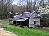
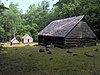
This is intended to be a complete list of the properties and districts on the National Register of Historic Places in Sevier County, Tennessee, United States. Latitude and longitude coordinates are provided for many National Register properties and districts; these locations may be seen together in a map. [1]

There are 38 properties and districts listed on the National Register in the county. Two properties were once listed, but have since been removed.

Map all coordinates using: OpenStreetMap  
Download coordinates as: KML
Contents: Counties in Tennessee
Anderson  Bedford  Benton  Bledsoe  Blount  Bradley  Campbell  Cannon  Carroll  Carter  Cheatham  Chester  Claiborne  Clay  Cocke  Coffee  Crockett  Cumberland  Davidson  Decatur  DeKalb  Dickson  Dyer  Fayette  Fentress  Franklin  Gibson  Giles  Grainger  Greene  Grundy  Hamblen  Hamilton  Hancock  Hardeman  Hardin  Hawkins  Haywood  Henderson  Henry  Hickman  Houston  Humphreys  Jackson  Jefferson  Johnson  Knox  Lake  Lauderdale  Lawrence  Lewis  Lincoln  Loudon  Macon  Madison  Marion  Marshall  Maury  McMinn  McNairy  Meigs  Monroe  Montgomery  Moore  Morgan  Obion  Overton  Perry  Pickett  Polk  Putnam  Rhea  Roane  Robertson  Rutherford  Scott  Sequatchie  Sevier  Shelby  Smith  Stewart  Sullivan  Sumner  Tipton  Trousdale  Unicoi  Union  Van Buren  Warren  Washington  Wayne  Weakley  White  Williamson  Wilson


    This National Park Service list is complete through NPS recent listings posted October 21, 2022. [2]

Current listings

[3] Name on the Register [4] ImageDate listed [5] Location City or townDescription
1 Riley H. Andes House
Riley H. Andes House Riley H. Andes House.jpg
Riley H. Andes House
July 8, 1980
(#80003854)
812 Old Douglas Dam Rd
35°53′01″N83°34′18″W / 35.883611°N 83.571667°W / 35.883611; -83.571667 (Riley H. Andes House)
Sevierville
2 Mayna Treanor Avent Studio
Mayna Treanor Avent Studio Aventcabinfull2b.jpg
Mayna Treanor Avent Studio
February 7, 1994
(#93001575)
Jake's Creek Trail, 1 mile (1.6 km) south of Elkton
35°38′21″N83°35′15″W / 35.639167°N 83.5875°W / 35.639167; -83.5875 (Mayna Treanor Avent Studio)
Elkmont
3 Brabson's Ferry Plantation
Brabson's Ferry Plantation Brabson-ferry-house-tn1.jpg
Brabson's Ferry Plantation
June 25, 1975
(#75001780)
1248 Indian Warpath Rd
35°55′45″N83°39′03″W / 35.929167°N 83.650833°W / 35.929167; -83.650833 (Brabson's Ferry Plantation)
Sevierville
4 Buckingham House
Buckingham House Buckingham House, Sevierville Pike, Knoxville vicinity (Sevier County, Tennessee).jpg
Buckingham House
March 18, 1971
(#71000831)
West of Sevierville on Sevierville Pike
35°54′58″N83°37′56″W / 35.916111°N 83.632222°W / 35.916111; -83.632222 (Buckingham House)
Sevierville
5 Clingmans Dome Observation Tower
Clingmans Dome Observation Tower Clingman's Dome Tower on a Sunny, Snowy Day.JPG
Clingmans Dome Observation Tower
August 15, 2012
(#12000515)
Terminus of Clingmans Dome Rd.
35°33′46″N83°29′55″W / 35.562766°N 83.498493°W / 35.562766; -83.498493 (Clingmans Dome Observation Tower)
Gatlinburg also listed in Swain County, North Carolina
6 Alex Cole Cabin
Alex Cole Cabin Alexcolecabin4.jpg
Alex Cole Cabin
January 2, 1976
(#76000165)
On the Roaring Fork Motor Nature Trail, 5 miles (8.0 km) south of Gatlinburg off U.S. Route 441 in Great Smoky Mountains National Park
35°39′59″N83°31′22″W / 35.666389°N 83.522778°W / 35.666389; -83.522778 (Alex Cole Cabin)
Gatlinburg
7 Douglas Hydroelectric Project
Douglas Hydroelectric Project Douglas Dam - Tennessee 001.jpg
Douglas Hydroelectric Project
August 14, 2017
(#100001475)
850 Powerhouse Way
35°57′40″N83°32′20″W / 35.961111°N 83.538889°W / 35.961111; -83.538889 (Douglas Hydroelectric Project)
Dandridge
8 Elkmont Historic District, Great Smoky Mountains NP
Elkmont Historic District, Great Smoky Mountains NP Ac-cottage-elkmont-tennessee.jpg
Elkmont Historic District, Great Smoky Mountains NP
March 22, 1994
(#94000166)
Off State Route 72 southwest of Gatlinburg
35°39′20″N83°35′04″W / 35.655556°N 83.584444°W / 35.655556; -83.584444 (Elkmont Historic District, Great Smoky Mountains NP)
Gatlinburg
9 First Methodist Church, Gatlinburg
First Methodist Church, Gatlinburg First Methodist Church, Gatlinburg.JPG
First Methodist Church, Gatlinburg
July 3, 2007
(#07000661)
742 Parkway
35°42′41″N83°31′02″W / 35.711389°N 83.517222°W / 35.711389; -83.517222 (First Methodist Church, Gatlinburg)
Gatlinburg
10 Harrisburg Covered Bridge
Harrisburg Covered Bridge Harrisburg Covered Bridge.jpg
Harrisburg Covered Bridge
June 10, 1975
(#75001777)
South of Harrisburg off U.S. Route 411 over East Fork of the Little Pigeon River
35°51′39″N83°28′58″W / 35.860833°N 83.482778°W / 35.860833; -83.482778 (Harrisburg Covered Bridge)
Harrisburg
11 Headrick's Chapel
Headrick's Chapel Wv-headrick4.jpg
Headrick's Chapel
July 19, 2001
(#01000756)
4327 Wears Valley Rd
35°42′00″N83°40′47″W / 35.699969°N 83.67967°W / 35.699969; -83.67967 (Headrick's Chapel)
Harchertown
12 Keener-Johnson Farm March 18, 1999
(#99000367)
1112 Boyd's Creek Highway
35°53′16″N83°43′47″W / 35.887659°N 83.729759°W / 35.887659; -83.729759 (Keener-Johnson Farm)
Seymour
13 King-Walker Place
King-Walker Place Walker-sisters-cabin1.jpg
King-Walker Place
March 16, 1976
(#76000169)
West of Gatlinburg off State Route 73 off the Little Brier Gap Trail in Great Smoky Mountains National Park
35°41′39″N83°37′45″W / 35.694167°N 83.629167°W / 35.694167; -83.629167 (King-Walker Place)
Gatlinburg
14 Little Greenbrier School-Church
Little Greenbrier School-Church Little-greenbrier-school1.jpg
Little Greenbrier School-Church
January 11, 1976
(#76000168)
About 9 miles (14 km) west of Gatlinburg off State Route 73 along the Metcalf Bottoms Trail in Great Smoky Mountains National Park
35°41′01″N83°38′17″W / 35.683611°N 83.638056°W / 35.683611; -83.638056 (Little Greenbrier School-Church)
Gatlinburg
15 Tyson McCarter Place
Tyson McCarter Place McCarter-place-tn1.jpg
Tyson McCarter Place
March 16, 1976
(#76000204)
10 miles (16 km) east of Gatlinburg on State Route 73 in Great Smoky Mountains National Park
35°46′N83°18′W / 35.76°N 83.3°W / 35.76; -83.3 (Tyson McCarter Place)
Gatlinburg
16 Messer Barn
Messer Barn Messer-barn-great-smokies1.jpg
Messer Barn
January 1, 1976
(#76000166)
Southeast of Gatlinburg near Greenbrier Cove along the Brushy Mountain Trail in Great Smoky Mountains National Park
35°41′13″N83°23′54″W / 35.686944°N 83.398333°W / 35.686944; -83.398333 (Messer Barn)
Gatlinburg
17 New Salem Baptist Church
New Salem Baptist Church New-salem-baptist-church-tn1.jpg
New Salem Baptist Church
July 24, 2003
(#03000696)
601 Eastgate Rd.
35°51′32″N83°33′14″W / 35.858889°N 83.553889°W / 35.858889; -83.553889 (New Salem Baptist Church)
Sevierville Built in 1886 by African-American brick mason Isaac Dockery; part of the Rural African-American Churches in Tennessee Multiple Property Submission (MPS)
18 Bud Ogle Farm
Bud Ogle Farm Noahoglecabin.jpg
Bud Ogle Farm
November 23, 1977
(#77000158)
On Cherokee Orchard Rd 3 miles (4.8 km) southeast of Gatlinburg
35°40′50″N83°29′28″W / 35.680556°N 83.491111°W / 35.680556; -83.491111 (Bud Ogle Farm)
Gatlinburg
19 John Ownby Cabin
John Ownby Cabin Johnownbycabin5.jpg
John Ownby Cabin
January 1, 1976
(#76000167)
On the Fighting Creek Nature Trail, 3 miles (4.8 km) south of Gatlinburg off State Route 73 in Great Smoky Mountains National Park
35°41′22″N83°32′50″W / 35.689444°N 83.547222°W / 35.689444; -83.547222 (John Ownby Cabin)
Gatlinburg
20 Perry's Camp
Perry's Camp Perry's Camp April 2012.JPG
Perry's Camp
October 30, 1992
(#92000369)
101 Flat Branch Rd.
35°43′31″N83°31′40″W / 35.725278°N 83.527778°W / 35.725278; -83.527778 (Perry's Camp)
Gatlinburg
21 Pigeon Forge Mill
Pigeon Forge Mill Oldmillpf2.jpg
Pigeon Forge Mill
June 10, 1975
(#75001778)
175 Old Mill Ave
35°47′18″N83°33′15″W / 35.788333°N 83.554167°W / 35.788333; -83.554167 (Pigeon Forge Mill)
Pigeon Forge
22 Pittman Community Center Home Economics Building
Pittman Community Center Home Economics Building Pittmancenter-cityhall1.jpg
Pittman Community Center Home Economics Building
November 29, 1996
(#96001406)
2839 Webb Creek Rd.
35°45′30″N83°23′44″W / 35.758333°N 83.395556°W / 35.758333; -83.395556 (Pittman Community Center Home Economics Building)
Pittman Center
23 Roaring Fork Historic District
Roaring Fork Historic District Jimbalesplace1.jpg
Roaring Fork Historic District
March 16, 1976
(#76000170)
5 miles (8.0 km) southeast of Gatlinburg off State Route 73 in Great Smoky Mountains National Park
35°41′54″N83°28′04″W / 35.698333°N 83.467778°W / 35.698333; -83.467778 (Roaring Fork Historic District)
Gatlinburg
24 Rocky Springs Presbyterian Church December 18, 2013
(#13000953)
2656 Boyds Creek Hwy.
35°55′23″N83°39′43″W / 35.923083°N 83.661938°W / 35.923083; -83.661938 (Rocky Springs Presbyterian Church)
Sevierville vicinity
25 Rose Glen
Rose Glen Rose-glen-house-tn1.jpg
Rose Glen
July 18, 1975
(#75001781)
4 miles (6.4 km) east of Sevierville on the Newport Highway
35°51′34″N83°29′58″W / 35.859444°N 83.499444°W / 35.859444; -83.499444 (Rose Glen)
Sevierville
26 Settlement School Community Outreach Historic District
Settlement School Community Outreach Historic District Arrowmont-arrowcraft-shop-tn1.jpg
Settlement School Community Outreach Historic District
July 11, 2007
(#07000686)
556 Parkway
35°42′46″N83°30′45″W / 35.712778°N 83.5125°W / 35.712778; -83.5125 (Settlement School Community Outreach Historic District)
Gatlinburg Comprises publicly accessible parts of the campus of the settlement school established by Pi Beta Phi that now houses the Arrowmont School of Arts and Crafts. [6] Part of the Pi Beta Phi Settlement School MPS
27 Settlement School Dormitories and Dwellings Historic District
Settlement School Dormitories and Dwellings Historic District Arrowmont-teachers-cottage-tn1.jpg
Settlement School Dormitories and Dwellings Historic District
March 20, 2007
(#07000185)
556 Parkway
35°42′45″N83°30′37″W / 35.7125°N 83.510278°W / 35.7125; -83.510278 (Settlement School Dormitories and Dwellings Historic District)
Gatlinburg Comprises residential portions of the campus of the settlement school established by Pi Beta Phi that now houses the Arrowmont School of Arts and Crafts. [7] Part of the Pi Beta Phi Settlement School MPS
28 Sevier County Courthouse
Sevier County Courthouse Sevier-county-tn-courthouse.jpg
Sevier County Courthouse
March 24, 1971
(#71000832)
Court Ave.
35°52′04″N83°33′58″W / 35.867778°N 83.566111°W / 35.867778; -83.566111 (Sevier County Courthouse)
Sevierville
29 Sevierville Commercial Historic District
Sevierville Commercial Historic District Court-avenue-sevierville.jpg
Sevierville Commercial Historic District
October 23, 1986
(#86002910)
Sections of Bruce St., Court Ave., and Commerce St.
35°52′05″N83°33′57″W / 35.868056°N 83.565833°W / 35.868056; -83.565833 (Sevierville Commercial Historic District)
Sevierville
30 Shults Grove Methodist Church
Shults Grove Methodist Church Shults Grove Methodist Church.jpg
Shults Grove Methodist Church
November 22, 2016
(#16000790)
505 Balls Hollow Rd E
35°47′02″N83°17′47″W / 35.783774°N 83.296410°W / 35.783774; -83.296410 (Shults Grove Methodist Church)
Cosby
31 Thomas Addition Historic District March 17, 1994
(#94000197)
Roughly bounded by Park Rd., Belle Ave., Cedar St., Grace Ave., and Prince St.
35°51′39″N83°33′38″W / 35.860935°N 83.560511°W / 35.860935; -83.560511 (Thomas Addition Historic District)
Sevierville
32 Trotter-McMahan House October 10, 1975
(#75001783)
1848 Middle Creek Rd
• Boundary increase (listed November 21, 2001, refnum 01001262): 1605 Middle Creek Rd.

35°49′49″N83°32′22″W / 35.830278°N 83.539444°W / 35.830278; -83.539444 (Trotter-McMahan House)
Sevierville
33 US Post Office-Sevierville
US Post Office-Sevierville US Post Office-Sevierville.JPG
US Post Office-Sevierville
March 14, 1997
(#97000240)
167 Bruce St.
35°52′01″N83°33′51″W / 35.866944°N 83.564167°W / 35.866944; -83.564167 (US Post Office-Sevierville)
Sevierville
34 Dwight and Kate Wade House
Dwight and Kate Wade House Wade-house-sevier-tn1.jpg
Dwight and Kate Wade House
December 15, 1997
(#97001502)
114 Joy St.
35°51′59″N83°33′55″W / 35.866389°N 83.565278°W / 35.866389; -83.565278 (Dwight and Kate Wade House)
Sevierville Built in 1940 by Fred McMahan, designed by New York architect Verna Cook Salomonsky
35 Walker Mill Hydroelectric Station
Walker Mill Hydroelectric Station Walker Mill Hydroelectric Station.JPG
Walker Mill Hydroelectric Station
November 20, 1990
(#90001751)
West Prong of the Little Pigeon River just off U.S. Route 441
35°50′44″N83°34′08″W / 35.845556°N 83.568889°W / 35.845556; -83.568889 (Walker Mill Hydroelectric Station)
Sevierville part of the Pre-TVA Hydroelectric Power Development in Tennessee MPS
36 Waters House
Waters House Lewis-buckner-design-sevierville.jpg
Waters House
June 18, 1975
(#75001784)
217 Cedar St.
35°51′56″N83°33′46″W / 35.865556°N 83.562778°W / 35.865556; -83.562778 (Waters House)
Sevierville
37 Wheatlands
Wheatlands Wheatlands-sevier-tn1.jpg
Wheatlands
July 7, 1975
(#75001785)
2507 TN-338
35°55′07″N83°40′06″W / 35.918611°N 83.668333°W / 35.918611; -83.668333 (Wheatlands)
Sevierville

Former listings

[3] Name on the RegisterImageDate listedDate removedLocationCity or townDescription
1 Mountain View Hotel September 13, 1984
(#84003681)
December 13, 1999400 Parkway
Gatlinburg Demolished in March and April, 1993. [8]
2 Sevierville Masonic Lodge February 7, 1980
(#80003855)
April 12, 2022119 Main St.
35°52′06″N83°33′50″W / 35.868333°N 83.563889°W / 35.868333; -83.563889 (Sevierville Masonic Lodge)
Sevierville Demolished in 2006 for a parking lot. [9]

See also

Related Research Articles

This is a list of properties and historic districts in Tennessee that are listed on the National Register of Historic Places. There are over 2,000 in total. Of these, 29 are National Historic Landmarks. Each of Tennessee's 95 counties has at least one listing.

<span class="mw-page-title-main">National Register of Historic Places listings in Santa Barbara County, California</span>

This is a list of the National Register of Historic Places listings in Santa Barbara County, California.

<span class="mw-page-title-main">National Register of Historic Places listings in Sevier County, Utah</span>

This is a list of the National Register of Historic Places listings in Sevier County, Utah.

<span class="mw-page-title-main">National Register of Historic Places listings in Sanpete County, Utah</span>

This is a list of the National Register of Historic Places listings in Sanpete County, Utah.

This is a list of the National Register of Historic Places listings in Davidson County, Tennessee.

This is a list of the National Register of Historic Places listings in Obion County, Tennessee.

This is a list of the National Register of Historic Places listings in Bradley County, Tennessee.

This is a list of the National Register of Historic Places listings in Cocke County, Tennessee.

This is a list of the National Register of Historic Places listings in Weakley County, Tennessee.

This is a list of the National Register of Historic Places listings in Washington County, Tennessee.

This is a list of the National Register of Historic Places listings in Tipton County, Tennessee.

This is a list of the National Register of Historic Places listings in Sullivan County, Tennessee.

This is a list of the National Register of Historic Places listings in Roane County, Tennessee.

This is a list of the National Register of Historic Places listings in Hardeman County, Tennessee.

This is a list of the National Register of Historic Places listings in Lawrence County, Tennessee.

This is a list of the National Register of Historic Places listings in Haywood County, Tennessee.

This is a list of the National Register of Historic Places listings in Marshall County, Tennessee.

This is a list of the National Register of Historic Places listings in Madison County, Tennessee.

<span class="mw-page-title-main">National Register of Historic Places listings in Sevier County, Arkansas</span>

This is a list of the National Register of Historic Places listings in Sevier County, Arkansas.

This is a list of the National Register of Historic Places listings in Great Smoky Mountains National Park.

References

  1. The latitude and longitude information provided in this table was derived originally from the National Register Information System, which has been found to be fairly accurate for about 99% of listings. Some locations in this table may have been corrected to current GPS standards.
  2. National Park Service, United States Department of the Interior, "National Register of Historic Places: Weekly List Actions", retrieved October 21, 2022.
  3. 1 2 Numbers represent an alphabetical ordering by significant words. Various colorings, defined here, differentiate National Historic Landmarks and historic districts from other NRHP buildings, structures, sites or objects.
  4. "National Register Information System". National Register of Historic Places . National Park Service. April 24, 2008.
  5. The eight-digit number below each date is the number assigned to each location in the National Register Information System database, which can be viewed by clicking the number.
  6. http://www.state.tn.us/environment/hist/pdf/settlement_cohd.pdf [ bare URL PDF ]
  7. http://www.state.tn.us/environment/hist/pdf/settlement&dwellings.pdf [ bare URL PDF ]
  8. "Piece of Gatlinburg history a memory with Mountain View Hotel demolition". The Knoxville News Sentinel . April 7, 1993. p. S1. Retrieved August 29, 2022 via Newspapers.com.
  9. "NRHP continuation sheet" (PDF). tn.gov.