
Bekal Fort is a medieval fort built by Shivappa Nayaka of Keladi in 1650 AD, at Bekal. It is the largest fort in Kerala, spreading over 40 acres (160,000 m2).
Kannur is one of the 14 districts along the west coast in the state of Kerala, India. The city of Kannur is the district headquarters and gives the district its name. The old name, Cannanore, is the anglicized form of the Malayalam name "Kannur". Kannur district is bounded by Kasaragod District to the north, Kozhikode district to the south, Mahé district to the southwest and Wayanad District to the southeast. To the east, the district is bounded by the Western Ghats, which forms the border with the state of Karnataka. The Arabian Sea lies to the west. Paithalmala is the highest point in Kannur District (1,372m). Enclosed within the southern part of the district is the Mahé district of the Union Territory of Puducherry. The district was established in 1957.

Thalassery, formerly Tellicherry, is a municipality and commercial city on the Malabar Coast in Kannur district in the state of Kerala, India, bordered by the districts of Mahe, Kozhikode, Wayanad, Kasaragod and Kodagu (Karnataka). Thalassery municipality has a population of just under 100,000 as of 2011 census. Thalassery Heritage City has an area of 23.98 square kilometres (9.26 sq mi). Thalassery has an altitude ranging from 2.5 to 30 metres above mean sea-level.

Brahmagiri, is a mountain range in the Western Ghats of south India. It is situated on the border between Kodagu district in Karnataka state in the north and Wayanad district of Kerala state on the south. Brahmagiri Hill, at 1608 m height, is a scenic tourist attraction. The top of Brahmagiri Hill is well forested and has much wildlife.
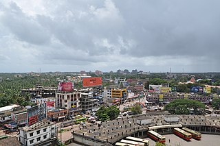
Kannur, formerly known in English as Cannanore, is a city and a municipal corporation in the state of Kerala, India. It is the administrative headquarters of the Kannur district and situated 274 kilometres (170 mi) north of the major port city and commercial hub Kochi and 137 kilometres (85 mi) south of the major port city and a commercial hub, Mangalore. During the period of British colonial rule in India, when Kannur was a part of the Malabar District, the city was known as Cannanore. Kannur is the sixth largest urban agglomeration in Kerala. As of 2011 census, Kannur Municipal Corporation, the local body which administers mainland area of city, had a population of 232,486.
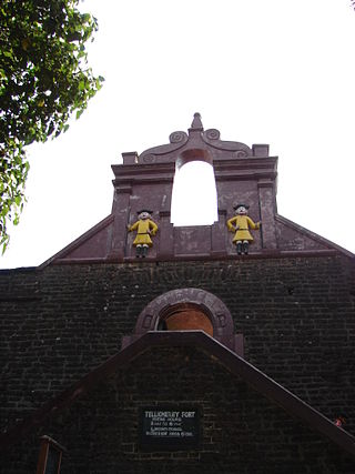
Tellicherry Fort is located in Thalassery (Tellicherry), a town in Kannur District of Kerala state, South India. Thalassery was one of the most important European trading centers in Kerala. The Fort lies on a group of low wooden hills running down to the sea and is protected by natural waters. It has been the main outlet for the rich spices, hill products, and timber of the vast hinterland.

Mappila Bay is a natural harbor situated at Ayikkara in Kannur Municipal Corporation, Kerala state of South India. On one side of the bay is Fort St. Angelo, built by the Portuguese in the 15th century and the other side is the Arakkal Palace.

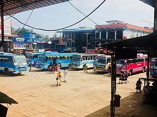
Mattanur, also spelled Mattannur, is a town, municipality, and an aerotropolis in Kannur district, Kerala, India. Mattanur is about 27 km east of Kannur and Thalassery, two major towns of the district.

Muzhappilangad Beach is a drive-in beach in the Kannur district of Kerala, on the Malabar Coast of India. It stretches across 4 kilometres in length. In 2016, it was featured among the six "best beaches for driving" in an article published by BBC - Autos.
Irikkur is a town and grama panchayat in Kannur District of Kerala state, India.

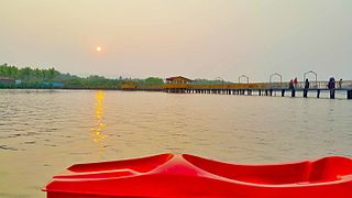
Thalassery Pier, locally known as Kadalpalam, is located in Thalassery, Kannur District of Kerala state, South India.

Brennen College is an educational institution in Kerala, affiliated to the Kannur University. It is located in Dharmadam, Thalassery of Kerala state, India. The college evolved from a school established by the English philanthropist Edward Brennen, master attendant of the Thalassery Port, who had made Thalassery his home. The college was granted special heritage status by the University Grants Commission in 2016 with an aim of conserving college which is more than 125 years old. The college secured 97th position in NIRF all India ranking.

Thalassery Stadium is located near the Thalassery Civil Station, Kerala state, South India. Thalassery Stadium hosts the Ranji Trophy cricket matches every year. It has a capacity of 7,500.
Nadapuram is a census town and a special grade Panchayath located in Kozhikode District of Kerala, coming under Nadapuram assembly constituency. It is in North Malabar region of Kerala, India; spread over an area of 20.44 km2

Kottiyoor is a Township,Village and Grama Panchayat situated in eastern hilly area of Kannur district in Kerala state. Kottiyoor is the 23rd Wildlife Sanctuary of Kerala, located in the serene hills of Western Ghats. The ancient pilgrimage conducted here yearly, called 'Kottiyoor Vysakha Mahotsavam' attracts around 50,000 devotees every year. The Vavali river flows through Kottiyoor.
Thalassery State assembly constituency is one of the 140 state legislative assembly constituencies in Kerala. It is also one of the seven state legislative assembly constituencies included in the Vatakara Lok Sabha constituency. As of the 2021 assembly elections, the MLA is A. N. Shamseer of CPI(M).
There are places of worship considered important in the Kannur district. Kannur District is one of the 14 districts in the state of Kerala, India. The town of Kannur is the district headquarters, and gives the district its name.
Kariyad is a small village in Talassery taluk of Kannur district in the Indian state of Kerala. It is part of the Greater Mahe Region. It is 57.31 km.2 The total population according to the 1991 census is 123,628.
Thalassery was a trade hub where Chinese, Arab, and Jewish traders had considerable influence in the spice market before that the Greeks and Romans was in the trade. It was the European invasion that brought significant change as they enforced the trade with their military.
The Thalassery carnival, the Beach fest in Muzhappilangad beach and Dharmadam beach are notable attractions. The area's four rivers around Thalassery town and four beaches with more in Kannur also attract visitors.


