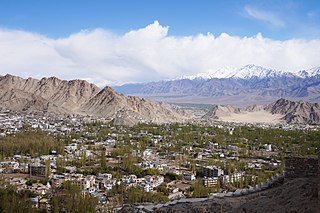
Leh district is a district in the union territory of Ladakh, a territory administered as part of India. With an area of 45,110 km2, it is the second largest district in the country smaller only to Kutch. It is bounded on the north by Gilgit-Baltistan's Kharmang and Ghanche districts and Xinjiang's Kashgar Prefecture and Hotan Prefecture linked via the historic Karakoram Pass. It has Aksai Chin and Tibet are to the east, Kargil district to the west, and Lahul and Spiti to the south. The district headquarters is in Leh. It lies between 32 to 36 degree north latitude and 75 to 80 degree east longitude.

Likir is a village and headquarter of eponymous Subdivision in the Leh district of Ladakh, India. It is located in the Likir tehsil, in the Ladakh region. Khalatse is a nearby trekking place.

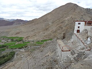
Shey is a village in the Leh district of Ladakh, India. It is located in the Leh tehsil, 15 km from Leh towards Hemis.
Tegar, also known as Kyagar, is a high-altitude village in the Leh district of Ladakh, India. It is located in the Nubra tehsil, in the Nubra Valley.

Kanji is a village in the Leh district of the union territory of Ladakh in India. It is located in the Khalsi tehsil, and can be accessed through the village of Heniskot which lies on the Srinagar-Kargil-Leh highway.

Upshi is a village and road junction on the Leh-Manali Highway in the union territory of Ladakh in India. It is located 47 km (29 mi) to the southeast of Leh along the Indus river valley and Tanglang La on the Leh-Manali highway. Gya is also to the south.

Nimo is the headquarters of the Nimoo block in the Leh district of Ladakh, India. It is located in the Likir tehsil, 35 km from Leh.
Nyoma is a principal village of southern Ladakh in India, the headquarters of an eponymous subdivision, tehsil and block in the Leh district. It is located on the bank of Indus River, after its 90-degree bend near Dungti and before the valley narrows to a gorge near Mahe. A Buddhist monastery ("gompa") is located on the hill at the back of the village.

Chamshan and Charasa is a village in the Leh district of Ladakh, India. It is located in the Nubra tehsil. The road to Chamshen valley is very accessible all throughout the season while Charasa, having closest village to Chamshen because of the river in between still need to take a long way from Koyak Bridge by stretching approximately 40km more.
Bazgoo is a village in the Leh district of Ladakh, India. It is located in the Likir tehsil.
Taroo is a village in the Leh district of Ladakh, India. It is located in the Likir tehsil.
Hanu is a village panchayat in the Leh district of Ladakh, India. It consists of two villages, Yogma Hanu and Goma Hanu, a few miles to the north, in the Hanu valley below the Chorbat La pass. The villages form part of the Khalsi tehsil.
Anlay is a village in the Leh district in the Indian union territory of Ladakh. It is located in the Nyoma tehsil.
Durbuk or Darbuk, is a village and the headquarters of the eponymous subdivision and block in the Leh district of Ladakh, India. It is located in the Durbuk tehsil, and falls between Chang La mountain pass and Tangste village on the way to Pangong Tso Lake.

Gia or Gya is a village in the Leh district of Ladakh in India. It is located in the Kharu tehsil, off the Leh–Manali Highway, close to Tso Kar.
Ney is a village in the Leh district of Ladakh, India. It is located in the Leh tehsil.
Meroo is a village in the Leh district of Ladakh, India. It is located in the Kharu tehsil.

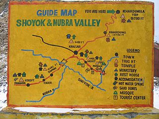
Khardong is a village in the Leh district of Ladakh, India. It is located in the Nubra tehsil, 31 km by road north of Khardung La.
Suspol, also spelled Saspol, is a village and eponymous tehsil headquarter in the Leh district of Ladakh in India.
Langokor is a village in the Leh district of Ladakh, India. It is located in the Kharu tehsil.

