Pumptown, New Jersey | |
---|---|
Coordinates: 40°33′47″N74°22′24″W / 40.56306°N 74.37333°W | |
Country | United States |
State | New Jersey |
County | Middlesex |
Township | Edison |
Elevation | 108 ft (33 m) |
GNIS feature ID | 879554 [1] |
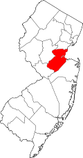
Pumptown (also known as Pumptown Corners) is an unincorporated community located within Edison Township in Middlesex County, in the U.S. state of New Jersey. [2] [3] [4] [5]
Pumptown is named after a public pump that stood in the middle of the intersection of Park Ave. and Plainfield Rd. [6]
It is a suburban neighborhood (based on population density), its real estate primarily made up of medium-sized (three- or four-bedroom) to large (four- or more bedroom) single-family homes and townhomes. Most of the residential real estate is owner-occupied. Many are older, well-established, built between 1940 and 1969. A number of residences were also built between 1970 and 1999. [7]
Route 27 is a state highway in New Jersey, United States. It runs 38.53 mi (62.01 km) from U.S. Route 206 (US 206) in Princeton, Mercer County northeast to an interchange with Route 21 and Broad Street in Newark, Essex County. The route passes through many communities along the way, including New Brunswick, Highland Park, Edison, Metuchen, Rahway, and Elizabeth. Route 27 is a two- to four-lane undivided highway for most of its length, passing through a variety of urban and suburban environments. It intersects many roads along the way, including Route 18 in New Brunswick, Interstate 287 (I-287) in Edison, the Garden State Parkway in Woodbridge Township, Route 35 in Rahway, Route 28 in Elizabeth, and U.S. Route 22 in Newark. Route 27 crosses the Raritan River on the Albany Street Bridge, which connects Highland Park on the east with New Brunswick on the west.
Middlesex County is a county located in the north-central part of the U.S. state of New Jersey, extending inland from the Raritan Valley region to the northern portion of the Jersey Shore. As of the 2020 United States census, the county was the state's third-most populous county with a population of 863,162, its highest decennial count ever and an increase of 53,304 (+6.6%) from the 2010 census count of 809,858, which in turn reflected an increase of 59,696 (8.0%) from the 750,162 counted in the 2000 census. Middlesex is part of the New York metropolitan area. Many communities within the county serve as commuter towns to and from New York City and other points north. The county is part of the Central Jersey region of the state.
Edison is a township located in Middlesex County, in the U.S. state of New Jersey. Situated in Central New Jersey within the core of the state's Raritan Valley region, Edison is a commercial hub and is a bedroom community of New York City within the New York metropolitan area.
Highland Park is a borough in Middlesex County, in the U.S. state of New Jersey, in the New York City metropolitan area. The borough is located on the northern banks of the Raritan River, in the Raritan Valley region. As of the 2020 United States census, the borough's population was 15,072, an increase of 1,090 (+7.8%) from the 2010 census count of 13,982, which in turn reflected a decline of 17 (−0.1%) from the 13,999 counted in the 2000 census.
Metuchen is a suburban borough in Middlesex County in the U.S. state of New Jersey. The borough is a commuter town of New York City, located in the heart of the Raritan Valley region within the New York Metropolitan area. The borough, along with Edison, is a regional commercial hub for Central New Jersey. The borough is 6 miles (9.7 km) northeast of New Brunswick, 17 miles (27 km) southwest of Newark, 20 miles (32 km) southwest of Jersey City, and 22 miles (35 km) southwest of Manhattan. As of the 2020 United States census, the borough's population was 15,049, an increase of 1,475 (+10.9%) from the 2010 census count of 13,574, which in turn reflected an increase of 734 (+5.7%) from the 12,840 counted in the 2000 census.
Route 440 is a state highway in New Jersey, United States. It comprises two segments, a 5.1-mile (8.2 km) freeway in Middlesex County linking I-287 and the New Jersey Turnpike (I-95), in Edison to the Outerbridge Crossing in Perth Amboy and an 8.18-mile (13.16 km) four-lane divided highway in Hudson County running from the Bayonne Bridge in Bayonne to Truck US Route 1-9 in Jersey City. These two segments are connected by NY 440, which runs across Staten Island. The freeway portion in Middlesex County is six lanes wide and interchanges the Garden State Parkway and US 9 in Woodbridge.
Central Jersey, or Central New Jersey, is the middle region of the U.S. state of New Jersey. The designation Central Jersey is a distinct administrative toponym. While New Jersey is often divided into North Jersey and South Jersey, many residents recognize Central Jersey as a distinct third entity. As of the 2020 census, Central Jersey has a population of 3,580,999.
Maurer is residential neighbourhood and industrial district of Perth Amboy in Middlesex County, in the U.S. state of New Jersey. Its name is derived from the "company town" built there in 1876. It is north of the Route 440 approach to the Outerbridge Crossing and south of the Perth Amboy Refinery, which began in 1920 as the Barber Asphalt Company. For a time it was known as Barber, a name which has fallen out of use
Stelton is an unincorporated community located within Edison Township in Middlesex County, in the U.S. state of New Jersey.
Bonhamtown is a section of Edison Township in Middlesex County, New Jersey, United States.
Clara Barton is an unincorporated community located within Edison Township in Middlesex County, in the U.S. state of New Jersey. It takes its name from Clara Barton.
Morgan is a neighborhood in Sayreville in Middlesex County, in the U.S. state of New Jersey, named for Charles Morgan III who purchased the land on May 7, 1710.
New Dover is an unincorporated community located within Edison Township in Middlesex County, in the U.S. state of New Jersey. The neighborhood began as colonial village that was part of adjacent Woodbridge Township. Along with Bonhamtown, New Durham and Stelton, it is one of the older historical communities of the township.
New Durham was an unincorporated community and now a neighborhood located within Edison in Middlesex County, New Jersey, United States, south of Dismal Swamp.
Potters was an unincorporated community and is now a neighborhood within Edison Township in Middlesex County, in the U.S. state of New Jersey.
Morsemere is a neighborhood in Bergen County, in the U.S. state of New Jersey, largely in the northern part of Ridgefield and straddling the border of Palisades Park south of start of U.S. Route 46.
Piscatawaytown is the oldest neighborhood in Edison in Middlesex County, New Jersey. It was established in the 1660s as the original village in what was then within Piscataway. Piscatawaytown is centered around St. James Church, the Piscatawaytown Burial Ground and the Piscatawaytown Common, near the intersection of Plainfield and Woodbridge Avenues.