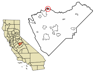
Shirley Meadows, California

Last updated
Shirley Meadows
Unincorporated community
California Locator Map with US.PNG
Red pog.svg
Shirley Meadows
Location in California
Usa edcp location map.svg
Red pog.svg
Shirley Meadows
Shirley Meadows (the US)
Coordinates: 35°42′39″N118°33′23″W / 35.71083°N 118.55639°W / 35.71083; -118.55639 Coordinates: 35°42′39″N118°33′23″W / 35.71083°N 118.55639°W / 35.71083; -118.55639
Country United States
State California
County Kern County
Elevation [1] 6,552 ft (1,997 m)

Shirley Meadows is an unincorporated community in Kern County, California. [1] It is located 1.25 miles (2 km) south-southwest of Alta Sierra, [2] at an elevation of 6,552 ft (1,997 m). [1]

Unincorporated area Region of land not governed by own local government

In law, an unincorporated area is a region of land that is not governed by a local municipal corporation; similarly an unincorporated community is a settlement that is not governed by its own local municipal corporation, but rather is administered as part of larger administrative divisions, such as a township, parish, borough, county, city, canton, state, province or country. Occasionally, municipalities dissolve or disincorporate, which may happen if they become fiscally insolvent, and services become the responsibility of a higher administration. Widespread unincorporated communities and areas are a distinguishing feature of the United States and Canada. In most other countries of the world, there are either no unincorporated areas at all, or these are very rare; typically remote, outlying, sparsely populated or uninhabited areas.

Kern County, California County in California, United States

Kern County is a county in the U.S. state of California. As of the 2010 census, the population was 839,631. Its county seat is Bakersfield.

California State of the United States of America

California is a state in the Pacific Region of the United States. With 39.6 million residents, California is the most populous U.S. state and the third-largest by area. The state capital is Sacramento. The Greater Los Angeles Area and the San Francisco Bay Area are the nation's second and fifth most populous urban regions, with 18.7 million and 8.8 million residents respectively. Los Angeles is California's most populous city, and the country's second most populous, after New York. California also has the nation's most populous county, Los Angeles County, and its largest county by area, San Bernardino County. The City and County of San Francisco is both the country's second-most densely populated major city after New York and the fifth-most densely populated county, behind only four of the five New York City boroughs.

Related Research Articles

Alpine Meadows, California Unincorporated community in California, United States

Alpine Meadows is an unincorporated community in Placer County, California. The community is located on Bear Creek, a tributary of the Truckee River 5 miles (8.0 km) west of Tahoe City, at an elevation of 6,480 ft (1,980 m).

Butte Meadows, California census-designated place in California, United States

Butte Meadows is a census-designated place in Butte County, California, 5 miles off State Route 32 on Humboldt Rd. The area is about 45 minutes or 33 miles (53 km) east of Chico on SR32. Its elevation is listed at 4,340 feet (1,323 m) above sea level: certain to get snow in winter of any year. The area code is Area code 530. The area is just over one mile (1.6 km) from the Tehama County line. The post office that served Butte Meadows moved back and forth across the county line several times from 1878 to 1888. Butte Meadows' population was 40 at the 2010 census.

Buck Meadows, California Census designated place in California, United States

Buck Meadows is a census-designated place in Mariposa County, California. It is located 2 miles (3.2 km) east-northeast of Smith Peak, at an elevation of 3015 feet. The population was 31 at the 2010 census.

Jonesville, California Unincorporated community in California, United States

Jonesville is an unincorporated community in Butte County, California. It is situated on Jones Creek, 5 miles (8.0 km) east-northeast of Butte Meadows, at an elevation of 5049 feet.

Lomo, Butte County, California Unincorporated community in California, United States

Lomo is an unincorporated community in Butte County, California. It lies 4.5 miles (7.2 km) of Butte Meadows, at an elevation of 3779 feet. A post office operated at Lomo from 1878 to 1881.

Big Meadow, California Unincorporated community in California, United States

Big Meadow is an unincorporated community in Calaveras County, California, about 2.5 miles (4 km) south of Tamarack. It lies at an elevation of 6558 feet.

Ganns, California Unincorporated community in California, United States

Ganns is an unincorporated community in Calaveras County, California. It lies at an elevation of 6742 feet.

McKay Meadow is a former settlement in Butte County, California, United States. It was located just north of Powellton.

Powellton Meadow is a former settlement in Butte County, California, United States. It was located just south of Powellton.

Jacobsen, California Former settlement in California, United States

Jacobsen is a former settlement in El Dorado County, California. It was located 2.5 miles (4 km) west-southwest of Wentworth Springs, at an elevation of 5860 feet. The site is now called Jacobsen Meadow.

Meadow Brook, California Unincorporated community in California, United States

Meadow Brook is an unincorporated community in El Dorado County, California. It is located 6.5 miles (10 km) north of Chili Bar, at an elevation of 2277 feet.

Springfield Meadows, California Unincorporated community in California, United States

Springfield Meadows is an unincorporated community in El Dorado County, California. It lies at an elevation of 577 feet.

Meadow Lakes, California Unincorporated community in California, United States

Meadow Lakes is an unincorporated community in Fresno County, California. It is located 6.5 miles (10 km) west-southwest of Shaver Lake Heights, at an elevation of 4452 feet.

Haiwee, California Unincorporated community in California, United States

Haiwee is an unincorporated community in Inyo County, California. It is located on the Southern Pacific Railroad 24 miles (39 km) south-southwest of Keeler, at an elevation of 4075 feet.

Shirley, Kings County, California Unincorporated community in California, United States

Shirley is an unincorporated community in Kings County, California. It is located on the Atchison, Topeka and Santa Fe Railroad 4.5 miles (7.2 km) north of Hanford, at an elevation of 259 feet (79 m).

La Barr Meadows, California Former settlement in California, United States

La Barr Meadows is a former settlement in Nevada County, California, located near Grass Valley. It was listed on an official map as of 1949.

Nashmead, California Unincorporated community in California, United States

Nashmead is an unincorporated community in Mendocino County, California. It is located on the Eel River and Northwestern Pacific Railroad 4 miles (6.4 km) south-southeast of Spyrock, at an elevation of 814 feet.

Edmanton, California Former settlement in California, United States

Edmanton is a former settlement in Plumas County, California. It lay at an elevation of 4741 feet. Edmanton is located on Big Creek, 2.5 miles (4.0 km) southwest of Meadow Valley.

Silver Creek, Plumas County, California Former settlement in California, United States

Silver Creek is a former settlement in Plumas County, California. It lay at an elevation of 3724 feet. Silver Creek is located 1.25 miles (2.0 km) north-northwest of Meadow Valley.

Spanish Ranch, California Unincorporated community in California, United States

Spanish Ranch is an unincorporated community in Plumas County, California. It lies at an elevation of 3668 feet. Spanish Ranch is located 1.25 miles (2.0 km)north- northeast of Meadow Valley.

References

  1. 1 2 3 U.S. Geological Survey Geographic Names Information System: Shirley Meadows, California
  2. Durham, David L. (1998). California's Geographic Names: A Gazetteer of Historic and Modern Names of the State. Clovis, Calif.: Word Dancer Press. p. 1105. ISBN   1-884995-14-4.