Sugar Grove Petroglyphs

Last updated

Sugar Grove Petroglyph Site (36GR5)
Sugar Grove Petroglyphs.jpg
Heavily wooded and on private land, this is a largely obscured view of the area of the site
USA Pennsylvania location map.svg
Red pog.svg
Usa edcp location map.svg
Red pog.svg
LocationOff Pennsylvania Route 88, 0.7 miles (1.1 km) northwest of its bridge over Whiteley Creek in Monongahela Township [1] :115
Nearest city Masontown, Pennsylvania
Coordinates 39°49′36″N79°57′40″W / 39.82667°N 79.96111°W / 39.82667; -79.96111
Area0.1 acres (0.040 ha)
NRHP reference No. 86000476 [2]
Added to NRHPMarch 20, 1986

The Sugar Grove Petroglyphs are a group of petroglyphs in the southwestern part of the U.S. state of Pennsylvania. Located on an outcrop of sandstone in Monongahela Township near the eastern edge of Greene County, the petroglyphs have been known since at least the 1930s. Due to their value as an archaeological site, the petroglyphs have been named a historic site.

Contents

Creation

It is certain that the Sugar Grove Petroglyphs are the work of a Native American people, although the cultural affiliation of their creators is unknown. Among the cultures that archaeologists have seen as possible creators are the Monongahela or Fort Ancient, both of which are known to have inhabited the upper portions of the Ohio River valley. [3] :4 In his 1974 monograph Rock Art of the Upper Ohio Valley, petroglyph specialist James L. Swauger argued for a Monongahela-related and proto-Shawnee identity of the creators; this conclusion he drew from the presence of carvings that he interpreted as representations of Ojibwe religious subjects. Although the Ojibwe never inhabited southwestern Pennsylvania, Swauger believed that the ancestors of the Shawnee shared these subjects as part of a common cultural heritage. [1] :112

Geology

The petroglyphs were carved into the flat portion of a large outcrop of Dunkard-series sandstone; [1] :67 it rises somewhat more than 4 feet (1.2 m) above the ground on its western side, but its other edges are level with the floor of the surrounding woodland. The petroglyphs are confined to a roughly square area of the stone that measures approximately 23 feet (7.0 m) on each side, [1] :68 although most appear on the eastern side and center of this area. [1] :68

Carvings

Forty-eight different carvings are present on the sandstone; although most are Native American artwork, a few have been added by vandals since European settlement of southwestern Pennsylvania. [1] :68 Swauger grouped the designs into six categories, [3] :2 as follows: [1] :68–69

CategoryNumber of carvings
Abstract designs23
Birds and footprints10
Complete and partial human figures8
Animals and footprints4
Arrows2
Nut-cracking holes1

Identification of the various designs has been complicated by erosion; some designs, especially those that are clustered closely together, have deteriorated and are thus difficult to classify conclusively. Among the most difficult are the carvings that were identified as bird tracks; they may have originally been abstract designs or arrowheads. [1] :69 Likewise, many abstract designs may have been created as identifiable designs, with their present conditions being the result of vandalism, later Native American carvings, or erosion. The most distinctive image on the rock is a large, almost circular animal that appears to be swallowing its tail; due to its unique shape and great size [its diameter is approximately 5 feet (1.5 m)], it has been seen as the most important single petroglyph at the site. [1] :70 It has been claimed that the site was damaged by quarrying circa 1950, but the only damage visible in a 1960 survey was small bits of stone that had been chipped away, possibly by vandals attempting to remove individual carvings. [1] :68 A 1982 survey discovered that the site had not changed since the 1960 survey. [3] :2

Recognition

Locals have long known the petroglyphs as the "Picture Rocks;" [3] :2 its original scholarly recognition was under this name, producing confusion in archaeological records after the site was separately recorded under the name of "Sugar Grove Petroglyphs." [1] :68 The first appearance of the Sugar Grove Petroglyphs in scholarly literature was no later than 1931, when they were given a short appearance in an archaeological survey of adjacent Fayette County. More detailed surveys in 1934 and 1950 led respectively to the publication of detailed drawings of the designs and to formal recognition as an archaeological site. [3] :2

Finding preservation of the designs to be a priority, the Carnegie Museum of Natural History arranged for the production of plaster casts of the designs during the twentieth century. [3] :2 Sugar Grove has been seen as one of western Pennsylvania's most important petroglyph sites: although it is smaller than many others, its location has spared it from the fate of many waterside petroglyphs that have been submerged by the construction of major dams, and it has suffered less vandalism than many other sites that occupy dry ground. [3] :4

In recognition of their archaeological value, the Sugar Grove Petroglyphs were listed on the National Register of Historic Places in 1986. They are one of four petroglyph sites in Pennsylvania to have received this designation, along with the Indian God Rock in Venango County, the Francis Farm Petroglyphs in Fayette County, and the Big and Little Indian Rock Petroglyphs in Lancaster County. [2]

Related Research Articles

<span class="mw-page-title-main">Jefferson Township, Fayette County, Pennsylvania</span> Township in Pennsylvania, United States

Jefferson Township is a township in Fayette County, Pennsylvania, United States. The population was 2,007 at the 2020 census, a decline from the figure of 2,008 tabulated in 2010. It is named for former president Thomas Jefferson, and many of the township's streets are named after other U.S. presidents. Frazier School District serves the area.

<span class="mw-page-title-main">Monongahela Township, Pennsylvania</span> Township in Pennsylvania, United States

Monongahela Township is a township in Greene County, Pennsylvania, United States. The population was 1,483 at the 2020 census, down from 1,572 at the 2010 census.

<span class="mw-page-title-main">Petroglyph</span> Images carved on a rock surface as a form of rock art

A petroglyph is an image created by removing part of a rock surface by incising, picking, carving, or abrading, as a form of rock art. Outside North America, scholars often use terms such as "carving", "engraving", or other descriptions of the technique to refer to such images. Petroglyphs, estimated to be 20,000 years old are classified as protected monuments and have been added to the tentative list of UNESCO's World Heritage Sites. Petroglyphs are found worldwide, and are often associated with prehistoric peoples. The word comes from the Greek prefix petro-, from πέτρα petra meaning "stone", and γλύφω glýphō meaning "carve", and was originally coined in French as pétroglyphe.

<span class="mw-page-title-main">Fort Ancient</span> Archaeological culture in the Ohio River valley

Fort Ancient is a name for a Native American culture that flourished from c. 1000–1750 CE and predominantly inhabited land near the Ohio River valley in the areas of modern-day southern Ohio, northern Kentucky, southeastern Indiana and western West Virginia. Although a contemporary of the Mississippian culture, they are often considered a "sister culture" and distinguished from the Mississippian culture. While far from agreed upon, there is evidence to suggest that the Fort Ancient Culture were not the direct descendants of the Hopewellian Culture. It is suspected that the Fort Ancient Culture introduced maize agriculture to Ohio. The Fort Ancient Culture were most likely the builders of the Great Serpent Mound. Recent archeological study and carbon dating suggests that Alligator Mound in Granville also dates to the Fort Ancient era, rather than the assumed Hopewell era. It is believed that neither the Serpent or Alligator Mounds are burial locations, but rather served as ceremonial effigy sites.

<span class="mw-page-title-main">Jeffers Petroglyphs</span> United States historic place

The Jeffers Petroglyphs site is an outcrop in southwestern Minnesota with pre-contact Native American petroglyphs. The petroglyphs are pecked into rock of the Red Rock Ridge, a 23-mile (37 km)-long Sioux quartzite outcrop that extends from Watonwan County, Minnesota to Brown County, Minnesota. The exposed surface is approximately 150 by 650 feet and surrounded by virgin prairie. "The site lies in an area inhabited in the early historic period by the Dakota Indians, and both the style and form of some of the carvings are identical with motifs that appear on Dakota hide paintings and their quill designs and beadwork. Others are foreign to this Plains Indian tradition and seem to be much earlier in origin." Several old wagon trail ruts traverse the site, one of which is believed to be the old stage coach route from New Ulm, Minnesota to Sioux Falls, South Dakota.

<span class="mw-page-title-main">Monongahela culture</span> Archaeological culture in the US

The Monongahela culture were an Iroquoian Native American cultural manifestation of Late Woodland peoples from AD 1050 to 1635 in present-day Western Pennsylvania, western Maryland, eastern Ohio, and West Virginia. The culture was named by Mary Butler in 1939 for the Monongahela River, whose valley contains the majority of this culture's sites.

<span class="mw-page-title-main">Sanilac Petroglyphs Historic State Park</span> Park in Michigan, USA

Sanilac Petroglyphs Historic State Park is a state park in the U.S. state of Michigan. The park, also known as ezhibiigadek asin consists of 240 acres (97 ha) in Greenleaf Township, Sanilac County, in Michigan's Thumb. It contains the largest collection of Native American petroglyphs in Michigan. The carvings were created in the pre-Columbian era and represent aspects of Native American spirituality. An interpretive hiking trail within the park passes along the nearby Cass River.

<span class="mw-page-title-main">Fountain Bluff</span> Range of hills in the United States

Fountain Bluff is a large, isolated range of hills located in the floodplain of the Mississippi River, on the river's east bank in Fountain Bluff Township, Illinois. Its unusual geographic location was a result of glaciation during the previous Ice Age. It is known for its high steep sandstone cliffs along the river, its biodiversity and abundant Native American rock art.

The Prehistory of West Virginia spans ancient times until the arrival of Europeans in the early 17th century. Hunters ventured into West Virginia's mountain valleys and made temporary camp villages since the Archaic period in the Americas. Many ancient human-made earthen mounds from various mound builder cultures survive, especially in the areas of Moundsville, South Charleston, and Romney. The artifacts uncovered in these areas give evidence of a village society with a tribal trade system culture that included limited cold worked copper. As of 2009, over 12,500 archaeological sites have been documented in West Virginia.

American Indian Rock Art in Minnesota MPS is a Multiple Property Submission (MPS) of the eligibility of many rock art properties for listing on the National Register of Historic Places. The listing is to protect and preserve Native American petroglyphs, pictographs and petroform rock art sites in the present day U.S. state of Minnesota.

<span class="mw-page-title-main">Barnesville Petroglyph</span> Archaeological site in Ohio, United States

The Barnesville Petroglyph petroglyph site in the eastern part of the U.S. state of Ohio. Located approximately 3 miles (4.8 km) southwest of the village of Barnesville in Belmont County, the petroglyphs have been known both by archaeologists and the general public since the 1850s or earlier. Although the site was significantly damaged during the twentieth century, it is still a significant archaeological site, and has been named a historic site.

<span class="mw-page-title-main">Indian God Rock</span> United States historic place

Indian God Rock is a large boulder in the northwestern part of the U.S. state of Pennsylvania. Located near the unincorporated community of Brandon, it lies along the Allegheny River in Venango County's Rockland Township. It is significant for the large petroglyph on one of its sides. Because of the petroglyph, the rock has been an explorers' landmark, a tourist attraction, and an object of scholarly investigation.

<span class="mw-page-title-main">Fisher site</span> United States historic place

The Fisher site is an archaeological site in northwestern Greene County, Pennsylvania, United States. Located along a tributary of Wheeling Creek in northern Richhill Township, it was once occupied by a Monongahela village. It has been ranked as one of southwestern Pennsylvania's most important locations for prehistoric preservation.

<span class="mw-page-title-main">Francis Farm Petroglyphs</span> United States historic place

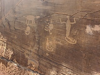
The Francis Farm Petroglyphs are a group of petroglyphs in the southwestern part of the U.S. state of Pennsylvania. Located on a boulder in Jefferson Township in the northwestern portion of Fayette County, it has been known to archaeologists since at least the middle of the nineteenth century. Despite damage in the 1930s, it remains an important archaeological site, and accordingly, it has been designated a historic site.

<span class="mw-page-title-main">James L. Swauger</span> American archaeologist (1913–2005)

James L. Swauger was an American archaeologist known for his work on the petroglyphs of the Ohio River valley of the United States. A native of West Newton in Westmoreland County, Pennsylvania, he moved to the Pittsburgh suburb of Edgewood in his youth; there he lived for most of the rest of his life.

<span class="mw-page-title-main">Protohistory of West Virginia</span> Protohistorical period

The protohistoric period of the state of West Virginia in the United States began in the mid-sixteenth century with the arrival of European trade goods. Explorers and colonists brought these goods to the eastern and southern coasts of North America and were brought inland by native trade routes. This was a period characterized by increased intertribal strife, rapid population decline, the abandonment of traditional life styles, and the extinction and migrations of many Native American groups.

<span class="mw-page-title-main">Petroglyph Canyon</span> United States historic place

Petroglyph Canyon (24CB601) is an archaeologically significant canyon in the northwestern United States. Located on both sides of the border between Montana and Wyoming, the canyon has long been obscure due to its small size. However, it gained substantial attention in the late 20th century because of its numerous prehistoric petroglyphs, and much of it was named a historic site in the 1970s.

<span class="mw-page-title-main">Lake Monongahela</span> Former lake in Pennsylvania, Ohio & West Virginia

Lake Monongahela was a proglacial lake in western Pennsylvania, West Virginia, and Ohio. It formed during the Pre-Illinoian ice epoch when the retreat of the ice sheet northwards blocked the drainage of these valleys to the north. The lake formed south of the ice front continued to rise until it was able to breach a low divide near New Martinsville, West Virginia. The overflow was the beginning of the process which created the modern Ohio River valley.

<span class="mw-page-title-main">Tainter Cave</span> United States historic place

Tainter Cave, also known as Tombstone Cave, is a dry sandstone cave in Crawford County, Wisconsin, in which prehistoric Native Americans carved petroglyphs and drew pictographs, including birds, men, deer, and abstract designs. With over 100 pictographs, the cave holds more than any other known site in Wisconsin. It is also notable as the first archaeological site recorded in the dark zone of a cave in the Upper Midwest.

References

  1. 1 2 3 4 5 6 7 8 9 10 11 Swauger, James L. Rock Art of the Upper Ohio Valley. Graz: Akademische Druck- und Verlagsanstalt, 1974.
  2. 1 2 "National Register Information System". National Register of Historic Places . National Park Service. March 13, 2009.
  3. 1 2 3 4 5 6 7 Herbstritt, James T. National Register of Historic Places Inventory/Nomination: Sugar Grove Petroglyph Site (36GR5). National Park Service, 1980-07-22.

Further reading