Sunday's River Valley Local Municipality

Last updated

Sundays River Valley
Sondagsriviervallei
Sundays River Valley CoA.png
Map of the Eastern Cape with Sundays River Valley highlighted.svg
Location in the Eastern Cape
Coordinates: 33°25′S25°27′E / 33.417°S 25.450°E / -33.417; 25.450
Country South Africa
Province Eastern Cape
District Sarah Baartman
Seat Kirkwood
Wards 8
Government
[1]
  Type Municipal council
  MayorNombulelo Bixa (ANC)
  SpeakerSimphiwe Happyboy Rune (ANC)
Area
  Total5,994 km2 (2,314 sq mi)
Population
 (2011) [2]
  Total54,504
  Density9.1/km2 (24/sq mi)
Racial makeup (2011)
[2]
   Black African 71.8%
   Coloured 21.4%
   Indian/Asian 0.2%
   White 5.9%
First languages (2011)
[2]
   Xhosa 64.3%
   Afrikaans 28.0%
   English 3.4%
  Other4.3%
Time zone UTC+2 (SAST)
Municipal codeEC106

Sundays River Valley Municipality (Xhosa : uMasipala wase Sundays River Valley; Afrikaans : Sondagsriviervallei Munisipaliteit) is a local municipality within Sarah Baartman District Municipality, in the Eastern Cape province of South Africa. It has a total population of nearly 70,000 people. The municipality is one of the key production areas for citrus in South Africa. It also encompasses the Addo Elephant National Park and other significant areas of nature conservation.

Contents

Main places

The 2001 census divided the municipality into the following main places: [3]

PlaceCodeArea (km2)PopulationMost spoken language
Addo Elephant National Park 20602 1.0890 Xhosa
Addo 20601 3.211,752 Afrikaans
Barsheba 20603 0.61517Xhosa
Bontrug 20604 2.336,806Xhosa
Enon 20605 0.40782Afrikaans
Kirkwood 20606 3.072,749Afrikaans
KwaZenzele 20607 3.623,733Xhosa
Nomathamsanqa 20608 1.539,266Xhosa
Paterson 20609 0.22671Afrikaans
Remainder of the municipality 20610 3,491.8315,218Xhosa

Politics

The municipal council consists of sixteen members elected by mixed-member proportional representation. Eight councillors are elected by first-past-the-post voting in eight wards, while the remaining eight are chosen from party lists so that the total number of party representatives is proportional to the number of votes received. In the election of 1 November 2021 the African National Congress (ANC) won a majority of ten seats on the council. The following table shows the results of the election. [4]

PartyWardListTotal
seats
Votes%SeatsVotes%Seats
African National Congress 7,17963.2077,25863.83310
Democratic Alliance 2,45621.6212,47121.7334
Economic Freedom Fighters 6315.5606475.6911
Good 2412.1205825.1211
Freedom Front Plus 2542.2402642.3200
Independent candidates 5094.4800
African Transformation Movement 490.430850.7500
Compatriots of South Africa 400.350640.5600
Total11,359100.00811,371100.00816
Valid votes11,35997.9611,37197.94
Invalid/blank votes2362.042392.06
Total votes11,595100.0011,610100.00
Registered voters/turnout25,03446.3225,03446.38

Geography and land use

The municipality derives its name from the 250 km (160 mi) long Sundays River, the fastest flowing river in South Africa. The river winds its way through the Zuurberg mountains and passes Kirkwood in the fertile Sundays River Valley; it empties into the Indian Ocean at Algoa Bay near Port Elizabeth.

To the north of Kirkwood lies the Rietberg mountain with the Uyepoort (Uye gateway) that provides passage to the Zuurberg mountains and the Greater Addo Elephant National Park. A panoramic view of Kirkwood and the orange groves is visible from The Lookout. The Lookout is also known as a site where large dinosaur fossils have been dug up by archeologists. The first complete dinosaur fossil to be found in South Africa, nicknamed "Kirky," was found not far from Kirkwood. [5]

The municipality comprises three regions with distinct characteristics: [6]

Demographics

The municipality's population (as of 2005) is 63% urban and 37% rural. 64% of the population are 34 years old or younger. Suggested unemployment rate figures range from 20% to 44%. In 2001, among persons older than 20 years, 5461 had had no schooling, 7642 had had some primary education, 2487 had completed primary school, another 6594 had had some secondary education, 2363 had finished Grade 12, and 827 had gone on to some higher level of schooling. [6]

Among individual residents, 41.63% earned no income in 2001; 45.74% earned R800 or less per month; 6.96% earned between R801 and R1600 per month; 5.71% earned over R1600 per month.

Approximately half of the municipality's households live on less than R800 (US $110) per month. [6]

Economy

The agricultural industry, centering mainly around citrus fruit, dairy and chicory farming, plays a major role in the economy and functioning of the region; it alone counts for 31.2% of the GGP and 47.7% of employment.

Approximately 25% of South Africa’s navel oranges and 50% of the country’s lemons are produced in the Sunday’s River Valley. The area exports million of cartons of navel oranges per year, earning more than R1 billion in foreign exchange for the country. Other agricultural products include vegetables, potatoes, maize, wheat, chicory, flowers and rye grass.

Ecotourism is another driving force of the local economy, thanks to the presence of vast unspoiled wilderness areas. Addo receives about 115 000 visitors each year, of which 50% are foreign, and this figure is on the increase. [6]

Related Research Articles

<span class="mw-page-title-main">Addo Elephant National Park</span> Diverse wildlife conservation park near Gqeberha in the Eastern Cape, South Africa

Addo Elephant National Park is a diverse wildlife conservation park situated close to Gqeberha in South Africa and is one of the country's 20 national parks. It currently ranks third in size after Kruger National Park and the Kgalagadi Transfrontier Park.

<span class="mw-page-title-main">KwaZulu–Cape coastal forest mosaic</span> Subtropical moist broadleaf forest ecoregion of South Africa

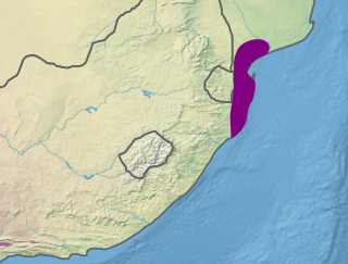
The Kwazulu-Cape coastal forest mosaic is a subtropical moist broadleaf forest ecoregion of South Africa. It covers an area of 17,800 square kilometers (6,900 sq mi) in South Africa's Eastern Cape and KwaZulu-Natal provinces.

<span class="mw-page-title-main">Maputaland coastal forest mosaic</span> Subtropical moist broadleaf forest ecoregion on the Indian Ocean coast of Southern Africa.

The Maputaland coastal forest mosaic is a subtropical moist broadleaf forest ecoregion on the Indian Ocean coast of Southern Africa. It covers an area of 29,961 square kilometres (11,568 sq mi) in southern Mozambique, Eswatini, and the KwaZulu-Natal Province of South Africa. Mozambique's capital Maputo lies within the ecoregion.

<span class="mw-page-title-main">Alexandria, South Africa</span> Place in Eastern Cape, South Africa

Alexandria is a small farming town in the Eastern Cape of South Africa and is situated 100 km North East of Gqeberha, Eastern Cape, on the way to Bushman's River Mouth, Kenton-on-Sea and Port Alfred. Alexandria is part of the Ndlambe Local Municipality in the Sarah Baartman District Municipality of the Eastern Cape.

<span class="mw-page-title-main">Sundays River</span> River in the Eastern Cape, South Africa

The !Khukaǁgamma or Sundaysriver is a river in the Eastern Cape Province of South Africa. It is said to be the fastest flowing river in the country. The Inqua Khoi people, who historically were the wealthiest group in Southern Africa, originally named this river !Khukaǁgamma because the river's banks are always green and grassy despite the arid terrain that it runs through.
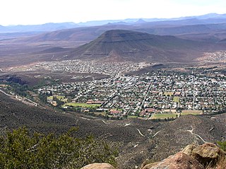
Kirkwood is a town in the Eastern Cape Province of South Africa. It is situated on the banks of the Sundays River in the eponymously named Sundays River Valley, which forms part of the Sundays River Valley Municipality in the Sarah Baartman District Municipality of the Eastern Cape.

<span class="mw-page-title-main">Orange (fruit)</span> Citrus fruit

An orange is a fruit of various citrus species in the family Rutaceae ; it primarily refers to Citrus × sinensis, which is also called sweet orange, to distinguish it from the related Citrus × aurantium, referred to as bitter orange. The sweet orange reproduces asexually ; varieties of the sweet orange arise through mutations.

The Addo Elephant Trail Run is a 25-, 50- and 100-mile event that takes place in and around the Addo Elephant National Park which is situated 75 kilometres (47 mi) north of the South African coastal city of Port Elizabeth.

The Sundays River Valley is a low-lying area along the Sundays River. It forms part of the Sunday's River Valley Local Municipality in Cacadu District Municipality, Eastern Cape, South Africa.

<span class="mw-page-title-main">Eliza Tibbets</span> California founder of the citrus industry

Eliza Tibbets was among early American settlers and founders of Riverside, California; she was an activist in Washington, D.C., for progressive social causes, including freedmen's rights and universal suffrage before going to the West Coast. A spiritualist, she led seances in Riverside. She became known for successfully growing the first two hybrid Washington navel orange trees in California.

Eastern Cape Parks are the national parks, marine protected areas, nature reserves and other nature conservation areas in the Eastern Cape province of South Africa. Eastern Cape Parks and Tourism Agency (ECPTA) is the governmental organisation responsible for maintaining wilderness areas and public nature reserves in the Eastern Cape, based in East London.

<span class="mw-page-title-main">History of Riverside, California</span> Timeline of the history of Riverside, California, United States

Riverside, California, was founded in 1870, and named for its location beside the Santa Ana River. It became the county seat when Riverside County, California, was established in 1893.

The Greater Addo Elephant National Park is a megapark in the making, and consists of the following parks:

<span class="mw-page-title-main">Albany thickets</span> Afrotropic terrestrial ecoregion of dense woodland in South Africa

The Albany thickets is an ecoregion of dense woodland in southern South Africa, which is concentrated around the Albany region of the Eastern Cape.

<span class="mw-page-title-main">Jansenville</span> Place in Eastern Cape, South Africa

Jansenville is a town in Sarah Baartman District Municipality in the Eastern Cape province of South Africa.

<span class="mw-page-title-main">Kirkwood Commando</span> Military unit

Kirkwood Commando was a light infantry regiment of the South African Army. It formed part of the South African Army Infantry Formation as well as the South African Territorial Reserve.

The following index is provided as an overview of and topical guide to the protected areas of South Africa:

The Addo Elephant National Park Marine Protected Area is a marine conservation area in Algoa Bay, adjacent to the Nelson Mandela Bay Metropolitan Municipality, near Gqeberha, previously Port Elizabeth.

<span class="mw-page-title-main">Suurberg</span>

The Suurberg is a mountain range in the southern Sarah Baartman District Municipality of the Eastern Cape, South Africa. The range of some 70 kilometres long is situated at the eastern end of the Cape Fold Belt, and rises just north of the towns of Kirkwood and Bontrug, and Paterson further east. Its rugged terrain is intersected by many defiles and ridge lines, rising from some 200 m a.s.l. in the south to 936 m a.s.l. The southern slopes are drained by various tributaries of the Sundays River, including the Kabouga, Uie, Wit and Krom Rivers. Two passes cross the mountain from south to north, namely the Suurberg Pass and Olifantskop Pass.

References

  1. "Contact list: Executive Mayors". Government Communication & Information System. Archived from the original on 14 July 2010. Retrieved 22 February 2012.
  2. 1 2 3 "Statistics by place". Statistics South Africa. Retrieved 27 September 2015.
  3. Lookup Tables - Statistics South Africa
  4. "Election Result Table for LGE2021 — Sunday's River Valley". wikitable.frith.dev. Retrieved 6 March 2022.
  5. "History and Culture." Sundays River Valley Municipality website. Retrieved on 14 October 2009.
  6. 1 2 3 4 Integrated Development Plan 2009/2010. Sundays River Valley Municipality. Retrieved on 14 October 2009.