
Mount Saskatchewan is a mountain located in the North Saskatchewan River valley of Banff National Park, in the Canadian Rockies of Alberta, Canada.
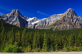
Howse Peak is the highest mountain in the Waputik Mountains, a subrange of the Canadian Rockies. It is located 5 km (3 mi) west of the Icefields Parkway, above Chephren Lake, on the continental divide between Alberta and British Columbia. At 3,295 m (10,810 ft), it is the 46th highest peak in Alberta, and the 59th highest in British Columbia.

Mount Aberdeen is a 3,152-metre (10,341-foot) mountain summit located in the Lake Louise area of Banff National Park, in the Canadian Rockies of Alberta, Canada. Its nearest higher peak is Mount Lefroy, 2.9 km (1.8 mi) to the southwest. Haddo Peak is on the same massif with Mount Aberdeen, and the Aberdeen Glacier is between the two peaks.

Mount Wilson is a 3,260-metre (10,696 ft) mountain summit located in the North Saskatchewan River valley of Banff National Park, in the Canadian Rockies of Alberta, Canada. Its nearest higher peak is Mount Cline, 9.81 km (6.10 mi) to the northeast. Mount Wilson is situated immediately north of the confluence of the North Saskatchewan River, Mistaya River, and Howse River near Saskatchewan Crossing, where the Icefields Parkway intersects with the David Thompson Highway.

Mount Murchison is a 3,348-metre (10,984 ft) mountain summit located at the convergence of the North Saskatchewan River valley and Mistaya River valley of Banff National Park, in the Canadian Rockies of Alberta, Canada. The main summit has two high points: the Southeast Peak is 3,348 m, whereas the Northwest Peak is 3,333 m and separated by 700 m distance. Its nearest higher peak is Mount Cline, 15.71 km (9.76 mi) to the north. Mount Murchison is situated immediately southeast of the confluence of the North Saskatchewan River, Mistaya River, and Howse River near Saskatchewan Crossing, where the Icefields Parkway intersects with the David Thompson Highway.
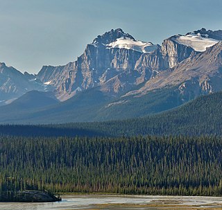
Epaulette Mountain is a 3,094-metre (10,151-foot) mountain summit in Alberta, Canada.

Kaufmann Peaks is a 3,110 and 3,094 metre double summit mountain located on a ridge between the Howse River valley and Mistaya River valley of Banff National Park, in the Canadian Rockies of Alberta, Canada. The nearest higher neighbor is Mount Sarbach, 2.0 km (1.2 mi) to the northwest, with Epaulette Mountain immediately to the southeast. Kaufmann Peaks is situated south of Saskatchewan Crossing, where the Icefields Parkway intersects with the David Thompson Highway.

Cirrus Mountain is a 3,270-metre (10,730-foot) mountain summit located in the upper North Saskatchewan River valley on the shared boundary between Banff National Park and White Goat Wilderness Area, in the Canadian Rockies of Alberta, Canada. Cirrus Mountain is situated along the east side the Icefields Parkway midway between Saskatchewan Crossing and Sunwapta Pass. Topographic relief is significant as the summit rises 1,740 meters (5,708 ft) above the parkway in 3 km (1.9 mi). The nearest higher peak is Mount Stewart, 5.92 km (3.68 mi) to the north-northeast.
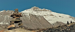
Nigel Peak is a 3,211-metre (10,535-foot) mountain summit located on the shared border of Banff National Park and Jasper National Park, in the Canadian Rockies of Alberta, Canada. Nigel has two peaks, the north summit is the highest point. The nearest higher peak is Mount Athabasca, 6.4 km (4.0 mi) to the south-southwest. Nigel Peak is situated immediately north of Sunwapta Pass and can be seen from the Icefields Parkway and from Athabasca Glacier. Topographic relief is significant as the summit rises 1,100 meters (3,610 feet) above the parkway in two kilometers (1.2 mile).

Mount Thompson is a 3,089-metre (10,135-foot) mountain summit located four kilometres west of Bow Lake in Banff National Park, in the Canadian Rockies of Alberta, Canada. Its nearest higher peak is Mount Baker, 5.0 km (3.1 mi) to the west. Mount Thompson is situated east of the Wapta Icefield, and is a member of the Waputik Mountains. Mount Thompson can be seen from the Icefields Parkway at Bow Lake.

Dolomite Peak is a 2,998-metre (9,836-foot) mountain summit located in the Bow River valley of Banff National Park, in the Canadian Rockies of Alberta, Canada. Its nearest higher peak is Cirque Peak, 3.98 km (2.47 mi) to the northwest. Dolomite Peak can be seen from the Icefields Parkway with its distinctive crags and colorful towers that are a mixture of dolomite and limestone. Dolomite is rare in the Rockies and is stronger than limestone.

Mount Weed is a 3,080-metre (10,100-foot) mountain summit located in the Mistaya River valley of Banff National Park, in the Canadian Rockies of Alberta, Canada. Mount Weed is situated at the confluence of Silverhorn Creek and Mistaya River, 3.5 kilometres southwest of Mount Noyes, 4.5 km east of Mistaya Lake, and 14 km north of Bow Lake. Its nearest higher peak is Mount Patterson, 5.82 km (3.62 mi) to the southwest. Patterson stands directly across the Mistaya River valley from Weed, and both are prominent features seen from the Icefields Parkway.

Watermelon Peak is a 3,095-metre (10,154-foot) summit located in Banff National Park, in the Canadian Rockies of Alberta, Canada. Its nearest higher peak is Deluc Peak, 13.5 km (8.4 mi) to the east.

The Mitre is a 2,850-metre (9,350-foot) mountain summit located in the Lake Louise area of Banff National Park, in the Canadian Rockies of Alberta, Canada. Its nearest higher peak is Mount Lefroy, 1.0 km (0.62 mi) to the west. Mount Aberdeen is 2.0 km (1.2 mi) to the north-northeast, Lefroy Glacier immediately north, Mitre Glacier southwest, and Paradise Valley to the southeast.

White Pyramid is a 3,219-metre (10,561 ft) mountain summit located between the Howse River valley and Mistaya River valley of Banff National Park, in the Canadian Rockies of Alberta, Canada. Its nearest higher peak is Howse Peak, 3.00 km (1.86 mi) to the south. Topographic relief is significant as the summit rises 1,460 meters (4,790 ft) above Chephren Lake in 2.5 km. White Pyramid is visible from the Icefields Parkway in the vicinity of Waterfowl Lakes.
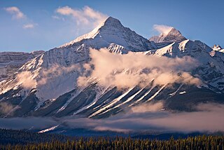
Mount Outram is a 3,245-metre (10,646-foot) mountain summit located in the Howse River Valley of Banff National Park, in the Canadian Rockies of Alberta, Canada. Its nearest higher peak is Mount Forbes, 4.37 km (2.72 mi) to the southwest. Glacier Lake is situated 4.0 km (2.5 mi) to the north, and the Sir James Glacier lies below the south aspect of the peak. Mount Outram can be seen from the Icefields Parkway southwest of Saskatchewan Crossing, with optimum photography conditions in morning light.

Hilda Peak is a 3,058-metre (10,033-foot) mountain summit located at the northern extreme of Banff National Park in the Canadian Rockies of Alberta, Canada. The nearest higher peak is Mount Athabasca, 2.0 km (1.2 mi) to the southwest. Hilda Peak is situated south of Sunwapta Pass and can be prominently seen from the Icefields Parkway. The Hilda Glacier lies to the south side of the peak, and the Boundary Glacier lies to the west.

Portal Peak is a 2,926-metre (9,600-foot) mountain summit located four kilometers west of Bow Lake in Banff National Park, in the Canadian Rockies of Alberta, Canada. Its nearest higher peak is Mount Thompson, 1.0 km (0.62 mi) to the northwest. Portal Peak is situated east of the Wapta Icefield, and is a member of the Waputik Mountains. Portal Peak can be seen from the Icefields Parkway at Bow Lake.
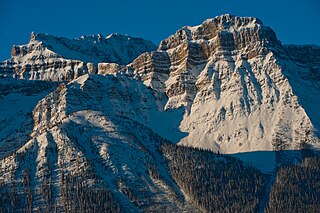
Pulpit Peak is a 2,720-metre (8,920-foot) mountain summit located one km south of Hector Lake in Banff National Park, in the Canadian Rockies of Alberta, Canada. Its nearest higher peak is Lilliput Mountain, 3.6 km (2.2 mi) to the southwest. Pulpit Peak is situated east of the Waputik Icefield, and is a member of the Waputik Mountains. Pulpit Peak can be seen from the Icefields Parkway towering 900 metres (2,950 ft) above Hector Lake.

Mount Noyes is a 3,080-metre (10,100-foot) mountain summit located in the Mistaya River valley of Banff National Park, in the Canadian Rockies of Alberta, Canada. Mount Noyes is situated at the confluence of Silverhorn Creek and Mistaya River, 3.5 km northwest of Mount Weed, and 9.2 km east of Howse Peak. Its nearest higher peak is Mount Patterson, 8.55 km (5.31 mi) to the south. Topographic relief is significant as it rises over 1,380 metres above the Icefields Parkway in two km.


