
Mount Blane is a 2,993-metre (9,820-foot) mountain summit located in the Opal Range of the Canadian Rockies of Alberta, Canada. Its nearest higher peak is Mount Jerram, 3.3 km (2.1 mi) to the southeast.
Mount Brock is a 2,902-metre (9,521-foot) mountain summit located in the Opal Range of the Canadian Rockies of Alberta, Canada. Its nearest higher peak is Mount Evan-Thomas, 3.3 km (2.1 mi) to the north.

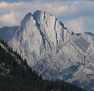
Mount Cornwall is a prominent 2,970-metre (9,740-foot) summit located between the Elbow River valley and Little Elbow River valley of Kananaskis Country in the Canadian Rockies of Alberta, Canada. The peak is visible from Highway 66, weather permitting. Mount Cornwall's nearest higher peak is Tombstone Mountain, 6.6 km (4.1 mi) to the southwest.

Elpoca Mountain is a 3,036-metre (9,961-foot) mountain summit located at the southern end of the Opal Range in the Canadian Rockies of Alberta, Canada. The nearest higher peak is Mount Evan-Thomas, 12.0 km (7.5 mi) to the north. Elpoca Mountain is situated 4.0 kilometres south of Mount Jerram, and 2.0 km east of Gap Mountain, and all are within Peter Lougheed Provincial Park. Precipitation runoff from the west side of the mountain drains into tributaries of the Kananaskis River, whereas the east side drains into Elbow River.

Mount Kidd is a 2,958-metre (9,705-foot) double-summit massif centrally located in Kananaskis Country in the Canadian Rockies of Alberta, Canada. Mount Kidd is situated within Spray Valley Provincial Park, and its nearest higher neighbor is Mount Sparrowhawk, 7.0 km (4.3 mi) to the northwest. Mount Kidd is a landmark that can be seen from Highway 40 in the Kananaskis Village area, and from the Kananaskis Country Golf Course which lies at the eastern base of the mountain.

Mount Wintour is a 2,700-metre (8,900-foot) ridge-like mountain summit located in the Opal Range of the Canadian Rockies of Alberta, Canada. It is situated in the Kananaskis River Valley east of Lower Kananaskis Lake and Highway 40 in Peter Lougheed Provincial Park. The nearest higher neighbor is Mount Jerram, 2.3 km (1.4 mi) to the east. The northern end of Mount Wintour forms the south canyon wall of King Creek which is a popular ice climbing destination. There are two climbing routes to the summit, the North Ridge and the South Ridge, both rated class 5.4.

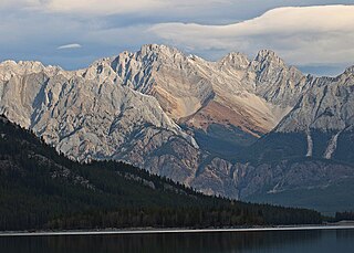
Mount Evan-Thomas is a 3,097-metre (10,161-foot) mountain summit located in the Opal Range of the Canadian Rockies of Alberta, Canada. Mount Evan-Thomas is the highest point in the Opal Range. It is situated in the Kananaskis River Valley northeast of Lower Kananaskis Lake and east of Highway 40 in Peter Lougheed Provincial Park. Its nearest higher peak is Mount Rae, 18.0 km (11.2 mi) to the south-southeast.
Mount Jerram is a 2,996-metre (9,829-foot) mountain summit located in the Opal Range of the Canadian Rockies of Alberta, Canada. Its nearest higher peak is Elpoca Mountain, 4.0 km (2.5 mi) to the south-southeast. Mount Jerram is situated east of Mount Wintour, within Peter Lougheed Provincial Park.

Gap Mountain is a 2,675-metre (8,776-foot) mountain summit located at the southern end of the Opal Range in the Canadian Rockies of Alberta, Canada. The nearest higher neighbor is Elpoca Mountain, 2 km (1.2 mi) to the east. Gap Mountain is situated 5 km (3.1 mi) south of Mount Wintour, within Peter Lougheed Provincial Park. Gap Mountain is a conspicuous peak seen from Alberta Highway 40 at Highwood Pass. It is a popular climbing destination because it offers exposed scrambling on its eastern flanks with excellent summit views of Kananaskis Country.

Mount French is a 3,244-metre (10,643-foot) summit in the Spray Mountains range of the Canadian Rockies in Alberta, Canada. The mountain is situated in Peter Lougheed Provincial Park of Kananaskis Country. French is the second highest point in the Spray Mountains Range. Its nearest higher peak, and highest in the Spray Range, is Mount Sir Douglas, 3.0 km (1.9 mi) to the west. Mount French can be seen from Alberta Highway 742, the Smith-Dorrien/Spray Trail.

Threepoint Mountain is the descriptive name for a three-pointed 2,595-metre (8,514-foot) mountain summit located in the Elbow River valley of Kananaskis Country, in the Canadian Rockies of Alberta, Canada. it is situated southwest of Calgary and can be seen from Highway 66. Threepoint Mountain's nearest higher peak is Bluerock Mountain, 4.7 km (2.9 mi) to the south. The mountain's name was made official in 1951 by the Geographical Names Board of Canada.

Mount Romulus is a 2,832-metre (9,291-foot) mountain summit located in the Little Elbow River Valley of Kananaskis Country in the Canadian Rockies of Alberta, Canada. Weather permitting, the peak is visible from highways southwest of Calgary as it is recognizable by its signature band of snow that forms above the broad southeast cliffs. The mountain is named for Romulus, who along with his twin brother Remus were the mythological founders of Ancient Rome. Mount Remus is situated 2.0 km (1.2 mi) to the east-northeast. The name was officially adopted by the Geographical Names Board of Canada in 1940. Mount Romulus' nearest higher peak is Fisher Peak, 4.0 km (2.5 mi) to the northwest.

Mount Smuts is a 2,938-metre (9,639-foot) mountain summit located in the Canadian Rockies of Alberta, Canada. It is set in the Spray Valley near the northern end of the Spray Mountains range. It is situated on the common boundary shared by Peter Lougheed Provincial Park with Banff National Park. Mount Smuts is not visible from any road in Banff Park, however it can be seen from Alberta Highway 742, also known as Smith-Dorrien/Spray Trail in Kananaskis Country. Mount Smuts' nearest higher neighbor is Mount Birdwood, 2.8 km (1.7 mi) to the south-southeast.

Mount Packenham is a 3,000-metre (9,800-foot) mountain summit located in the Opal Range of the Canadian Rockies of Alberta, Canada. Its nearest higher peak is Mount Evan-Thomas, 1.0 km (0.62 mi) to the north. Situated on the eastern boundary of Peter Lougheed Provincial Park, the peak is visible from Highway 40 and the Kananaskis Lakes area.

Commonwealth Peak is a 2,775-metre (9,104-foot) mountain summit in the Spray Mountains, a sub-range of the Canadian Rockies in Alberta, Canada. The mountain is situated in Peter Lougheed Provincial Park. Its nearest higher peak is Mount Birdwood, 1.0 km (0.62 mi) to the west. Both can be seen from Alberta Highway 742, also known as Smith-Dorrien/Spray Trail in Kananaskis Country.
Mount Murray is a 3,026-metre (9,928-foot) mountain summit in the Spray Mountains range of the Canadian Rockies in Alberta, Canada. The mountain is situated in Peter Lougheed Provincial Park of Kananaskis Country. Its nearest higher peak is Mount French, 2.0 km (1.2 mi) to the south-southwest. Mount Murray can be seen from Alberta Highway 742, the Smith-Dorrien/Spray Trail.

Mount Remus is a 2,688-metre (8,819-foot) mountain summit located in the Little Elbow River Valley of Kananaskis Country in the Canadian Rockies of Alberta, Canada. The mountain is named for Remus, who along with his twin brother Romulus were the mythological founders of Ancient Rome. The name was officially adopted by the Geographical Names Board of Canada in 1940. Mount Remus' nearest higher peak is Mount Romulus, 2.0 km (1.2 mi) to the west-southwest.

Fisher Peak is a 3,053-metre (10,016-foot) mountain summit located in the Fisher Range of Kananaskis Country in the Canadian Rockies of Alberta, Canada. Fisher Peak is the highest point in the Fisher Range, so its nearest higher peak is Mount Evan-Thomas, 7.0 km (4.3 mi) to the southwest in the Opal Range. Precipitation runoff from the mountain drains west into Evan-Thomas Creek, which is a tributary of the Kananaskis River, or east into the Little Elbow River which is a tributary of the Elbow River.

Mount Howard is a 2,777-metre (9,111-foot) mountain summit located 68 km (42 mi) west-southwest of Calgary in Kananaskis Country of Alberta, Canada. Mount Howard is the fourth-highest peak in the Fisher Range which is a subrange of the Canadian Rockies. The nearest higher neighbor is Fisher Peak, 5.03 km (3.13 mi) to the southwest. Precipitation runoff from the mountain drains into Nihahi Creek and Canyon Creek which are tributaries of the Elbow River. Topographic relief is modest as the summit rises 777 metres (2,549 ft) above Canyon Creek in approximately 2 km (1.2 mi).

Outlaw Peak is a 2,957-metre (9,701-foot) mountain summit located in Alberta, Canada.


