Neighborhoods of Davenport, Iowa

Last updated

Map highlighting the historic neighborhoods Map of Davenport, Iowa Neighborhoods.png
Map highlighting the historic neighborhoods
Map of Davenport. Map of Davenport Iowa.svg
Map of Davenport.

The city of Davenport, Iowa, United States has neighborhoods dating back to the 1840s. The Davenport Plan and Zoning Commission divided the city into five areas: downtown, central, east end, near north, and northwest and west end. The neighborhoods contain many architectural designs, including Victorian, Queen Anne, and Tudor Revival. Many of the original neighborhoods were first inhabited by German settlers.

Contents

Downtown

Downtown Davenport, Iowa looking across the Mississippi River from Rock Island, Illinois. Downtown Davenport.jpg
Downtown Davenport, Iowa looking across the Mississippi River from Rock Island, Illinois.

Downtown Davenport sits on the banks of the Mississippi River. Downtown is bordered on the south by the river; the east and north, by railroad tracks running on the north side along Fifth Street; and the west, by Warren Street. Downtown underwent several generations of growth beginning in the 1840s and 1850s. During this period, the buildings were all modest one- and two-story frame buildings. The prosperity of the 1880s and 1890s led to the development of upscale commercial buildings, during which the first department store, a five-story brick building, was constructed. Technological improvements in skeleton construction and elevators enabled buildings to reach new heights. Development in the west end of Downtown shifted from commercial to residential buildings, mostly in the form of apartments. [1] Downtown contains the two tallest buildings in the Quad Cities: the Wells Fargo Bank Building, which is 255 feet (78 m) tall, and the Mid-American Energy Building, which is 220 feet (67 m) tall. [2] Other tall buildings include the 11-story Blackhawk Hotel, the 150-foot (46 m) Kahl Building and the Davenport City Hall. [3] The Davenport Motor Row and Industrial Historic District, a former light industrial area, is located in the southeast corner of downtown between River Drive and Third Street. [4]

Central neighborhoods

The West Third Street neighborhood extends from Scott Street to Myrtle Street along West Third Street. The significance of this neighborhood is derived from the German-American community that originally lived in the neighborhood. Residents during that time period consisted mostly of members of the working class. The focus of the neighborhood was Washington Squarea single block laid out by Antoine LeClaire in the original city. The square was the site of German beer gardens, musical events, veterans' celebrations and other outdoor activities, and served as the welcoming point for new German immigrants. [1]

Hamburg is located northwest of Downtown, covering Fifth Street to Ninth Street and Ripley Street to Vine Street. The neighborhood contains the most architecturally significant buildings of the old German neighborhoods. [1] Hamburg slopes up to bluffs overlooking Downtown and the river. The neighborhood was a prime location for prominent Germans and contains mostly residential structures; there are very few commercial buildings or churches. The first dwellings were small single-story cottages modeled after the Greek Revival design. Other housing designs in the neighborhood include Victorian, Gothic Revival, Italianate, Second Empire, and Queen Anne. [1]

Cork Hill is located on a square mile of land east of the original town. [1] It was plotted by town founder Antoine LeClaire in the 1840s to 1880s, and housed the residence of LeClaire himself, his heirs, and Irish and transplanted American settlers. It contains densely built large- and medium-sized houses set close together as well as the Sacred Heart Cathedral. The houses are of the Italianate, Queen Anne cottage, Georgian, and Colonial Revival styles. [1]

East Fourteenth Street has sixty-seven houses from Pershing Street to Arlington Avenue along Fourteenth Street developed during the 1840s and the 1870s. During that time, the neighborhood contained mostly middle-class Irish immigrants and Americans. [1] The houses are fairly large and range from Victorian to Classical Revival styles, and all but one of the houses are wood frame. [1] The original neighborhood housed prominent entrepreneurs, industrialists, and professionals.

College Square is located north of Downtown, from Tenth Street to Fifteenth Street and Brady Street to Harrison Street (U.S. Route 61). Two blocks of the neighborhood on Harrison Street contain mid-nineteenth-century houses. Another two blocks are dedicated to large-scale education and religious buildings, including the Palmer College of Chiropractic campus. Most of the houses in the neighborhood date from 1860 to the early twentieth century. [1] Harrison and Main streets have become more commercialized over the years, along with the east side of Brady Street, while the west side of Brady Street still contains mostly residential buildings. [1]

East neighborhoods

Bridge Avenue The historic district stretches from River Drive along the Mississippi River up a bluff to East Ninth Street, which is near the top of the hill. The neighborhood is made up of fourteen houses on the southern end of Bridge Avenue. The houses were mostly built between 1870 - 1910. The most prominent of the residences was built by Ambrose Fulton, who was significant to Davenport's early settlement and its industrial history. He was an early and aggressive promoter of the new town.

One of the large houses in the McClellan Heights neighborhood McClellan Heights.jpg
One of the large houses in the McClellan Heights neighborhood

McClellan Heights is the largest neighborhood in the east end and sits on a 400 acres (1.6 km2) area east of the Village of East Davenport. It runs from Jersey Ridge Road to the Bettendorf city limits, and from River Drive to Middle Road. Four hundred houses make up the McClellan Heights neighborhood, dating from 1905 to 1940. [1] The land is made up of many hills and ravines; the streets follow the topography, requiring many winding roads and odd-shaped lots. [1] Developed from south to north, four very large mansions built before World War I were coveted by upper-middle class residents. Housing styles include American Craftsman, Prairie, American Foursquare, Colonial Revival, and Georgian. The neighborhood was mostly settled by Dutch and New England immigrants. The houses and a few brick streets that run through the neighborhood remain in good to excellent condition. [1]

Some of the houses in the Prospect Park Historic District. Prospect Park Davenport.jpg
Some of the houses in the Prospect Park Historic District.

Prospect Park is a small neighborhood located on the western border of the Village of East Davenport. It runs along Mississippi Street from Eleventh Street down to River Drive (U.S. Route 67) and a block east along Prospect Drive and Prospect Terrace. It was developed from 1895 to 1910, and is one of many Davenport neighborhoods built at the turn of the century to focus around a park. [1] Houses in Prospect Park are very large and are set on spacious lots. They are built in the late Queen Anne, Neoclassical, and Tudor Revival styles. The neighborhood housed many prominent figures, including contractors, physicians, and attorneys. [1] The proximity and commanding view of the river kept this neighborhood fashionable long after the original families had departed. [1] Unlike similar west end and central neighborhoods, Prospect Park has remained composed primarily of single-family homes.

The Village of East Davenport is full of small specialty shops. The picture was taken from Lindsay Park, which was used as parade grounds for Civil War soldiers from Camp McClellan. Village of East Davenport.jpg
The Village of East Davenport is full of small specialty shops. The picture was taken from Lindsay Park, which was used as parade grounds for Civil War soldiers from Camp McClellan.

The Village of East Davenport (known locally as The Village) is a neighborhood that dates back to the 1850s and was originally known as "Stubb's Eddy". The Village was established in 1851 to service the logging industry, and was annexed by the city in 1857. [1] It experienced three stages of growth: the period following the American Civil War, when many residential buildings were built; from 1890 to 1915, when construction of large mansions on the bluffs (allowing views of the Mississippi River) began; and the turn of the twentieth century, at the far east end of the neighborhood and the city. The houses in The Village were built along the curves of the topography, not in the grid fashion that was used in the rest of the city. [1]

Today, The Village consists of residential and commercial buildings (mostly small specialty shops). It is bounded to the west by Judson Street, to the north by Kirkwood Boulevard, to the east by Jersey Ridge Road, and to the south by River Drive. Set in a bowl-like valley, commercial buildings are in the southern part of the neighborhood, while residential buildings are in the northern part on the hillside. Lindsay Park is located in the southeast corner and was used as parade grounds for soldiers from Camp McClellan during the Civil War. [1] Today, the park contains play equipment and baseball diamonds and provides a view of the river.

Near north neighborhoods

At the turn of the twentieth century, development extended along transportation arteries and street car lines. The areas along Locust Street, Brady Street, and Harrison Street were developed around this time.

Vander Veer Park Historic District houses looking across Harrison Street. Vander Veer Houses.jpg
Vander Veer Park Historic District houses looking across Harrison Street.

Columbia Avenue is a neighborhood located north and west of Vander Veer Botanical Park. The area is entirely residential and it contains brick apartment buildings that were built between 1930 and 1939. It is one of the city's smallest districts and it is unique among the other historic districts in that it contains primarily apartment buildings. The neighborhood is made up of 19 four to six unit apartment buildings that were built between 1930 and 1939 and two similar structures built in the 1950s.

Oak Lane is a neighborhood that along Oak Lane from High Street south to Locust Street. The neighborhood contains 27 middle-class houses developed from 1900 to 1910 by Amos Cutter, a local real estate entrepreneur. It is a significant example of the speculative development which appeared in Davenport in the first decades of the twentieth century. [1]

Vander Veer Park consists of houses surrounding Vander Veer Botanical Park and is bounded to the north by Central Park Avenue, to the east by Brady Street, to the south by Lombard Street, and to the west by Harrison Street. The houses were built between 1895 and 1915 and are Queen Anne- and Tudor Revival-styled. The neighborhood is anchored on the south by a church and outing club. The park, originally named Central Park after the New York City park, was originally the site of the Scott County Fairgrounds. [1] The park was later renamed Vander Veer in honor of an early Davenport park commissioner. Development of Vander Veer Park was the first major beautification effort outside of two small spaces in downtown. [1]

Northwest and west end neighborhoods

View from Riverview Terrace Park overlooking Davenport. Rock Island, Illinois can be seen at the top of the picture across the Mississippi River. Riverview Terrace.jpg
View from Riverview Terrace Park overlooking Davenport. Rock Island, Illinois can be seen at the top of the picture across the Mississippi River.

At the time northwest Davenport was developed, during a post-Civil War expansion, it consisted of the area around Locust Street, Marquette Street, and Washington Street. The area housed many working-class Germans; it was plotted in the 1850s, and extensive development occurred in the 1870s. The houses were mostly one and a half- to two-story front gable American Foursquare and simplified Queen Anne buildings. The area around five-points, where three streets come together to form a five-point intersection, contained the bulk of the commercial structures. Alterations or replacements of almost all of the original buildings has diminished the significance of this historic area. [1] The West End part of the area is filled with people who are mildly poor to the point of Poverty and several are classified to be uneducated.

Riverview Terrace is a neighborhood that contains twenty-four houses and a 3-acre (12,000 m2) park. Riverview Terrace runs along Clay Street from Fillmore Street northwest to the edge of the old Marycrest International University. On the south side is Riverview Terrace Park, originally called Lookout Park, which is located on a large steep hill. The area around the park contains large Italianate, Georgian, and Federal-style houses. Beyond the park are smaller houses and brick streets.

Notes

  1. 1 2 3 4 5 6 7 8 9 10 11 12 13 14 15 16 17 18 19 20 21 22 23 Historic Preservation in Davenport, Iowa
  2. "Tallest Buildings In Q-C". Quad City Times. January 4, 2002. Retrieved March 5, 2011.
  3. "Ask the Times: Davenport buildings tower above the rest". Quad City Times. Retrieved October 5, 2008.
  4. Jennifer Irsfeld James, National Register of Historic Places Nomination Form: Davenport East Side Industrial and Motor Row Historic District (Draft), City of Davenport

Related Research Articles

<span class="mw-page-title-main">Davenport, Iowa</span> City in Iowa, United States

Davenport is a city in and the county seat of Scott County, Iowa, United States. Located along the Mississippi River on the eastern border of the state, it is the largest of the Quad Cities, a metropolitan area with a population of 384,324 and a combined statistical area population of 474,019, ranking as the 147th-largest MSA and 91st-largest CSA in the nation. According to the 2020 census, the city had a population of 101,724, making it Iowa's third-largest city. Davenport was founded on May 14, 1836, by Antoine Le Claire and named for his friend George Davenport.

<span class="mw-page-title-main">Neighborhoods of Tulsa, Oklahoma</span>

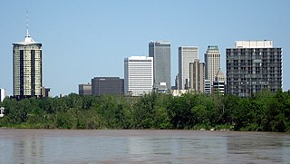
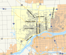
Tulsa is the second-largest city in the state of Oklahoma. It has many diverse neighborhoods due to its size.

<span class="mw-page-title-main">East Side (Milwaukee)</span> Area of Milwaukee, Wisconsin, United States

The East Side is a district of Milwaukee, Wisconsin consisting of several neighborhoods encompassing an area just north of Downtown Milwaukee to the village of Shorewood, bordered by the Milwaukee River to the west and Lake Michigan to the east. The area encompasses residences, museums, bars, shops, theaters, live music clubs and the University of Wisconsin–Milwaukee campus.

<span class="mw-page-title-main">Neighborhoods in Spokane, Washington</span>

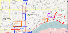
Neighborhoods in Spokane, Washington are officially grouped by the Spokane City Council into three main city council districts: 1, 2, and 3. Each city council district contains multiple, official neighborhoods that are recognized with a neighborhood council. Informally, neighborhoods are colloquially grouped by local geographical, geological, cultural, or historical features The list of neighborhoods below is organized based on the official designations by the City of Spokane. Unofficial neighborhoods and districts are listed within the official neighborhood in which they are located.

<span class="mw-page-title-main">Neighborhoods of Milwaukee</span>

The neighborhoods of Milwaukee include a number of areas in southeastern Wisconsin within the state's largest city at nearly 600,000 residents.

The following is a list of neighborhoods and commercial districts in Sioux City, Iowa.

Columbus, the state capital and Ohio's largest city, has numerous neighborhoods within its city limits. Neighborhood names and boundaries are not officially defined. They may vary or change from time to time due to demographic and economic variables.

<span class="mw-page-title-main">Prospect Hill, New Haven</span> Historic district in Connecticut, United States

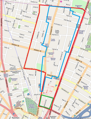
Prospect Hill is a neighborhood of the city of New Haven, Connecticut located in the north central portion of the city, directly north of Downtown New Haven. The neighborhood contains residences, institutional buildings of Albertus Magnus University and a portion of the main campus of Yale University, including the Science Hill area, the Hillhouse Avenue area and the Yale Peabody Museum. The City of New Haven defines the neighborhood to be the region bounded by the town of Hamden in the north, Winchester Avenue in the west, Munson Street/Hillside Place/Prospect Street in the southwest, Trumbull Street in the south, and Whitney Avenue in the east. Prospect Street is the main thoroughfare through the neighborhood.

<span class="mw-page-title-main">Vander Veer Park Historic District</span> Historic house in Iowa, United States

The Vander Veer Park Historic District is a historic district in Davenport, Iowa, United States, that was listed on the National Register of Historic Places. Over its 70.8-acre (287,000 m2) area, in 1985 it included 66 contributing buildings, two contributing structures, one contributing site, and one contributing object.

<span class="mw-page-title-main">Prospect Park Historic District (Davenport, Iowa)</span> Historic district in Iowa, United States

The Prospect Park Historic District in Davenport, Iowa, United States, is a historic district that was listed on the National Register of Historic Places in 1984. In its 23.2-acre (9.4 ha) area, it included 23 contributing buildings in 1984. The Prospect Park hill was listed on the Davenport Register of Historic Properties in 1993.

<span class="mw-page-title-main">Fourth and Gill, Knoxville</span> Historic house in Tennessee, United States

Fourth and Gill is a neighborhood in Knoxville, Tennessee, United States, located north of the city's downtown area. Initially developed in the late nineteenth century as a residential area for Knoxville's growing middle and professional classes, the neighborhood still contains most of its original Victorian-era houses, churches, and streetscapes. In 1985, 282 houses and other buildings in the neighborhood were added to the National Register of Historic Places as the Fourth and Gill Historic District.

<span class="mw-page-title-main">Dillon Memorial</span> United States historic place

The Dillon Memorial is a historic structure located in LeClaire Park, near downtown Davenport, Iowa, United States. It was listed on the National Register of Historic Places (NRHP) in 1983 and on the Davenport Register of Historic Properties in 1993. It is commonly referred to as the Dillon Fountain.

<span class="mw-page-title-main">Hamburg Historic District (Davenport, Iowa)</span> Historic district in Iowa, United States

The Hamburg Historic District, also known as the Gold Coast, is a residential neighborhood located on a bluff northwest of downtown Davenport, Iowa, United States. It is listed on the National Register of Historic Places in 1983. In 1999, it was listed on the Davenport Register of Historic Properties The historic district is where the city's middle and upper-income German community built their homes in the 19th and early 20th centuries. Germans were the largest ethnic group to settle in Davenport.

<span class="mw-page-title-main">West Third Street Historic District (Davenport, Iowa)</span> Historic district in Iowa, United States

West Third Street Historic District is located on the west side of downtown Davenport, Iowa, United States. It was listed on the National Register of Historic Places in 1983. The historic district connects the central business district with the working-class neighborhoods of the West End. Its historical significance is its connection to Davenport's German-American community. Germans were the largest ethnic group to settle in Davenport.

<span class="mw-page-title-main">Columbia Avenue Historic District</span> Historic district in Iowa, United States

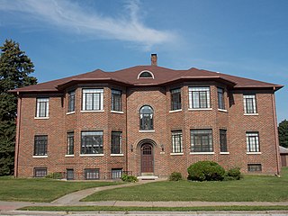
Columbia Avenue Historic District is located in the central part of the city of Davenport, Iowa, United States. It was listed on the National Register of Historic Places in 1984. The district lies north and west of Vander Veer Park. The area is entirely residential and it contains brick apartment buildings that were built between 1930 and 1939. It is one of the city's smallest districts and it is unique among the other historic districts in that it contains primarily apartment buildings.

<span class="mw-page-title-main">Bridge Avenue Historic District</span> Historic district in Iowa, United States

The Bridge Avenue Historic District is located in a residential neighborhood on the east side of Davenport, Iowa, United States. It has been listed on the National Register of Historic Places since 1983. The historic district stretches from River Drive along the Mississippi River up a bluff to East Ninth Street, which is near the top of the hill.

<span class="mw-page-title-main">St. Paul Lutheran Church (Davenport, Iowa)</span> Church in Iowa, United States

St. Paul Lutheran Church is located in central, Davenport, Iowa, United States. It is affiliated with the Evangelical Lutheran Church in America (ELCA). The church's original property, which subsequently housed other Protestant congregations, was listed on the National Register of Historic Places in 1983, but has since been torn down. The present complex was built in 1952 and contains two buildings that are contributing properties in the Vander Veer Park Historic District. The present church building was completed in 2007.

<span class="mw-page-title-main">National Register of Historic Places listings in Davenport, Iowa</span>

This is a list of the National Register of Historic Places listings in Davenport, Iowa. This is intended to be a complete list of the properties and districts on the National Register of Historic Places in Davenport, Iowa, United States. Latitude and longitude coordinates are provided for many National Register properties and districts; these locations may be seen together in an online map.

<span class="mw-page-title-main">West End North Historic District</span> Historic district in Connecticut, United States

The West End North Historic District encompasses a neighborhood of late 19th and early 20th century residential architecture in western Hartford, Connecticut and eastern West Hartford, Connecticut. Roughly bounded by Prospect, Elizabeth, and Lorraine Streets and Farmington Avenue, the area includes a large number of Colonial Revival and Queen Anne houses, as well as numerous buildings in other period styles, with only a small number of losses. It was listed on the National Register of Historic Places in 1985.

<span class="mw-page-title-main">Downtown Milwaukee</span> Area of Milwaukee, Wisconsin, United States

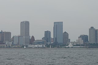
Downtown Milwaukee is the central business district of Milwaukee, Wisconsin. The economic and symbolic center of the city and the Milwaukee metropolitan area, it is Milwaukee's oldest district and home to many of region's cultural, financial educational and historical landmarks including Milwaukee City Hall, Fiserv Forum and the Milwaukee Art Museum. The city's modern history began in Downtown Milwaukee in 1795 when fur trader Jacques Vieau (1757–1852) built a post along a bluff on the east side, overlooking the Milwaukee and Menomonee rivers.

References