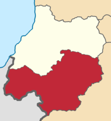
The Dagestan Oblast was a province (oblast) of the Caucasus Viceroyalty of the Russian Empire. It roughly corresponded to most of present-day southeastern Dagestan within the Russian Federation. The Dagestan oblast was created in 1860 out of the territories of the former Caucasian Imamate, bordering the Terek Oblast to the north, the Tiflis Governorate and Zakatal Okrug to the west, the Elizavetpol Governorate to the south, and Baku Governorate to the east. The administrative center of the oblast was Temir-Khan-Shura.

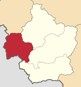
The Zakatal okrug was a special administrative district (okrug) of the Caucasus Viceroyalty of the Russian Empire, part of the Tiflis Governorate from 1893 to 1905. The administrative centre of the district was Zakataly, and it corresponded to most of the contemporary districts of Balakan, Zaqatala and Qax of Azerbaijan. The Zakatal okrug was established from the territories of the erstwhile Free Jamaats of Jar-Balakan, bordering the Tiflis Governorate to the west, the Elizavetpol Governorate to the south and the Dagestan Oblast to the north. The district was the smallest independent administrative unit of the Russian Empire, similarly to the Sukhumi okrug.

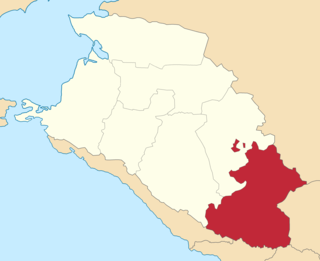
The Zugdidi uezd was a county (uezd) of the Kutaisi Governorate of the Caucasus Viceroyalty of the Russian Empire. It bordered the Sukhumi Okrug to the north, the Lechkhumi uezd to the east, the Senaki uezd to the south, and the Black Sea to the west. The area of the Zugdidi uezd corresponded to most of the contemporary Samegrelo-Zemo Svaneti region of Georgia. The county was eponymously named for its administrative center, Zugdidi.
The Olti okrug was a district (okrug) of the Kars Oblast of the Russian Empire existing between 1878 and 1918. Its capital was the town of Olty, presently part of the Erzurum Province of Turkey. The okrug bordered with the Kars okrug to the southeast, the Ardahan okrug to the northwest, the Kagizman okrug to its south, the Batum Oblast to the north, and the Erzurum vilayet of the Ottoman Empire to the west.

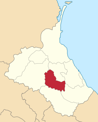
The Signakh uezd was a county (uezd) of the Tiflis Governorate of the Caucasus Viceroyalty of the Russian Empire, and then of Democratic Republic of Georgia, with its administrative centre in Signakh. The area of the county roughly corresponded to the contemporary Kakheti region of Georgia.

The Tiflis uezd was a county (uezd) of the Tiflis Governorate of the Caucasus Viceroyalty of the Russian Empire, and then of Democratic Republic of Georgia, with its administrative centre in Tiflis. The area of the uezd roughly corresponded to the contemporary Kvemo Kartli region of Georgia. The district bordered the Telavi uezd to the northeast, the Tionety and Dusheti uezds to the north, the Gori uezd to the northwest, the Borchaly uezd to the west, the Kazakh uezd of the Elizavetpol Governorate to the south, and the Signakh uezd to the east.

The Batumi okrug was a district (okrug) of the Batum Oblast of the Russian Empire existing between 1878 and 1918. The district was eponymously named for its administrative center, the town of Batum, now part of Adjara within Georgia. The okrug bordered with the Artvin okrug in the south, the Ardahan okrug of the Kars Oblast to the southeast, the Tiflis Governorate to the northeast, the Kutaisi Governorate to the north, and the Trebizond Vilayet of the Ottoman Empire to the west.
The Batalpashinsky otdel was a Cossack district of the Kuban oblast of the Caucasus Viceroyalty of the Russian Empire. It bordered the Stavropol Governorate to the north, the Labinsky and Maykopsky otdels to the west, the Sochi and Sukhumi okrugs to the south, and the Terek Oblast to the east. The area of the Batalpashinsky otdel included most of the contemporary Karachay-Cherkessia region of Russia. The administrative capital was the city of Batalpashinskaya.

The Avarskiy okrug was a district (okrug) of the Dagestan Oblast of the Caucasus Viceroyalty of the Russian Empire. The area of the Avarskiy okrug is included in contemporary Dagestan of the Russian Federation. The district's administrative centre was Khunzakh.

The Andiyskiy okrug was a district (okrug) of the Dagestan Oblast of the Caucasus Viceroyalty of the Russian Empire. The area of the Andiyskiy okrug is included in contemporary Dagestan of the Russian Federation. The district's administrative centre was Botlikh.

The Gunibskiy okrug was a district (okrug) of the Dagestan Oblast of the Caucasus Viceroyalty of the Russian Empire. The area of the Gunibskiy okrug is included in contemporary Dagestan of the Russian Federation. The district's centre was Gunib.

The Darginskiy okrug was a district (okrug) of the Dagestan Oblast of the Caucasus Viceroyalty of the Russian Empire. The area of the Darginskiy okrug is included in contemporary Dagestan of the Russian Federation. The district's administrative centre was Levashi.
The Kazikumukhskiy okrug was a district (okrug) of the Dagestan Oblast of the Caucasus Viceroyalty of the Russian Empire. The area of the Kazikumukhskiy okrug is included in contemporary Dagestan of the Russian Federation. The district's administrative centre was Kumukh.
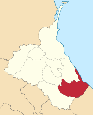
The Kaytago-Tabasaranskiy okrug was a district (okrug) of the Dagestan Oblast of the Caucasus Viceroyalty of the Russian Empire. The area of the Kaytago-Tabasaranskiy okrug is included in contemporary Dagestan of the Russian Federation. The district's administrative centre was Madzhalis.
The Kyurinskiy okrug was a district (okrug) of the Dagestan Oblast of the Caucasus Viceroyalty of the Russian Empire. The area of the Kyurinskiy okrug is included in contemporary Dagestan of the Russian Federation. The district's administrative centre was Kasumkent.
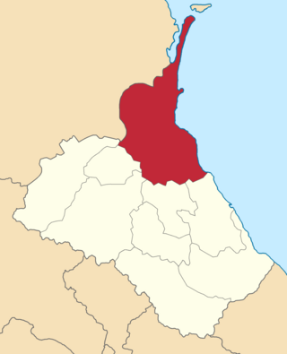
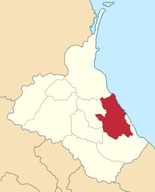
The Temir-Khan-Shurinskiy okrug was a district (okrug) of the Dagestan Oblast of the Caucasus Viceroyalty of the Russian Empire. The area of the Temir-Khan-Shurinskiy okrug is included in contemporary Dagestan of the Russian Federation. The district's administrative centre was Temir-Khan-Shura.

The Vedensky okrug was a district (okrug) of the Terek Oblast of the Caucasus Viceroyalty of the Russian Empire. The area of the Vedensky okrug made up part of the North Caucasian Federal District of Russia. The district was eponymously named for its administrative centre, Vedeno.

The Sunzhensky otdel was a Cossack district of the Terek oblast of the Caucasus Viceroyalty of the Russian Empire. The area of the Sunzhensky otdel makes up part of the North Caucasian Federal District of Russia.

The Vladikavkazsky okrug was a district (okrug) of the Terek Oblast of the Caucasus Viceroyalty of the Russian Empire. The area of the Vladikavkazsky okrug made up part of the North Caucasian Federal District of Russia. The district was eponymously named for its administrative centre, Vladikavkaz.

The Kizlyarsky otdel was a Cossack district of the Terek oblast of the Caucasus Viceroyalty of the Russian Empire. The area of the Kizlyarsky otdel makes up part of the North Caucasian Federal District of Russia. The district was eponymously named for its administrative center, Kizlyar.