
The Transcaucasian Democratic Federative Republic was a short-lived state in the Caucasus that included most of the territory of the present-day Armenia, Azerbaijan and Georgia, as well as parts of Russia and Turkey. The state lasted only for a month before Georgia declared independence, followed shortly after by Armenia and Azerbaijan.
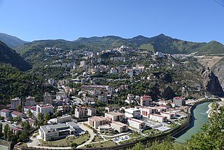
Artvin is a city in northeastern Turkey about 30 kilometres inland from the Black Sea.

The Provisional National Government of the Southwestern Caucasus, Provisional National Government of South West Caucasia or Kars Republic was a short-lived nominally-independent provisional government based in Kars, northeastern Turkey. Born in the wake of the Armistice of Mudros that ended World War I in the Middle East, it existed from December 1, 1918 until April 19, 1919, when it was abolished by British High Commissioner Admiral Somerset Arthur Gough-Calthorpe. Some historians consider it to have been a puppet state of the Ottoman Empire.

The Tiflis Governorate was a province (guberniya) of the Caucasus Viceroyalty of the Russian Empire with its administrative center in Tiflis. In 1897, it constituted 44,607 sq. kilometres in area and had a population of 1,051,032 inhabitants. The Tiflis Governorate bordered the Elizavetpol Governorate to the southeast, the Erivan Governorate to the south, the Kars Oblast to the southwest, the Batum Oblast to the west, the Kutaisi Governorate to the northwest, the Terek Oblast to the north, the Dagestan Oblast to the northeast, and after 1905, the Zakatal Okrug to the east. The governorate covered areas of central and southeastern Georgia, the partially recognised state of South Ossetia, most of the Lori Province of Armenia, small parts of northwestern Azerbaijan, and a minuscule southern part of Ingushetia within Russia.
The Kars Oblast was a province (oblast) of the Caucasus Viceroyalty of the Russian Empire between 1878 and 1917. Its capital was the city of Kars, presently in Turkey. The oblast bordered the Ottoman Empire to the west, the Batum Oblast to the north, the Tiflis Governorate to the northeast, and the Erivan Governorate to the east. The Kars Oblast included parts of the contemporary provinces of Kars, Ardahan, and Erzurum Province of Turkey, and the Amasia Community of the Shirak Province of Armenia.

The Erivan uezd was a county (uezd) of the Erivan Governorate of the Caucasus Viceroyalty of the Russian Empire. The uezd bordered the Etchmiadzin and Surmalu uezds to the west, the Nor Bayazet uezd to the east, the Sharur-Daralayaz uezd to the south, and Iran to the southwest. It included most of the Ararat Province and southern parts of the Kotayk Province of central Armenia, the Sadarak District of the Nakhchivan exclave of Azerbaijan, and the Aras corridor of the Aralık District of the Iğdır Province of Turkey. The administrative center of the Erivan uezd was the city of Erivan.
The Nakhichevan uezd was a county (uezd) of the Erivan Governorate of the Caucasus Viceroyalty of the Russian Empire. It bordered the governorate's Sharur-Daralayaz uezd to the north, the Zangezur uezd of the Elizavetpol Governorate to the east, and Iran to the south. The uezd's administrative center was the city of Nakhichevan.

The Kutaisi or Kutais Governorate was a province (guberniya) of the Caucasus Viceroyalty of the Russian Empire. It roughly corresponded to most of western Georgia throughout most of its existence, and most of the Artvin Province of Turkey between 1878 and 1903. Created out of part of the former Georgia-Imeretia Governorate in 1846, the governorate also included Akhaltsikhe uezd before its cession to the Tiflis Governorate in 1867. The Kutaisi Governorate bordered the Sukhumi Okrug to the northwest, the Kuban Oblast to the north, the Terek Oblast to the northeast, the Tiflis Governorate to the southeast, the Batum Oblast to the southwest, and the Black Sea to the west. The governorate was eponymously named for its administrative center, Kutais.

The Zakatal or Zakatali Okrug was a special administrative district (okrug) of the Caucasus Viceroyalty of the Russian Empire, part of the Tiflis Governorate from 1893 to 1905. The administrative centre of the district was the city Zakataly, and it corresponded to most of the contemporary districts of Balakan, Zaqatala and Qax of Azerbaijan. The Zakatal Okrug was established from the territories of the erstwhile Free Jamaats of Jar-Balakan, bordering the Tiflis Governorate to the west, the Elizavetpol Governorate to the south and the Dagestan Oblast to the north. The district was unique in that it was the smallest independent administrative unit of the Russian Empire, similarly to the Sukhumi Okrug.

The Caucasus Viceroyalty was the Russian Empire's administrative and political authority in the Caucasus region exercised through the offices of glavnoupravlyayushchiy and namestnik ("viceroy"). These two terms are commonly, but imprecisely, translated into English as viceroy, which is frequently used interchangeably with governor general. More accurately, glavnoupravlyayushchiy is referred to as the High Commissioner of the Caucasus, and namestnik as Viceroy.

The Surmalu uezd was a county (uezd) of the Erivan Governorate of the Caucasus Viceroyalty of the Russian Empire. It bordered the governorate's Etchmiadzin and Erivan uezds to the north, the Kars Oblast to the west, Persia to the east, and the Ottoman Empire to the south. The district made up most of the Iğdır Province of present-day Turkey. As part of the Russian Transcaucasus, the Surmalu uezd possessed economical importance for its abundantly rich salt mines in Kulp (Tuzluca), and spiritual importance to Armenians as the location of the culturally significant Mount Ararat. The administrative center of the uezd was the town Igdyr.

The Alexandropol uezd, known after 1924 as the Leninakan uezd, was a county (uezd) of the Erivan Governorate of the Caucasus Viceroyalty of the Russian Empire. The uezd bordered the governorate's Etchmiadzin and Nor Bayazet uezds to the south, the Borchaly and Akhalkalaki uezds of the Tiflis Governorate to the north, the Kazakh uezd of the Elizavetpol Governorate to the east, and the Kars Oblast to the west. The area of the uezd included most of the contemporary Shirak Province, and southern parts of the Lori Province of Armenia. The district was eponymously named for its administrative center, Aleksandropol, which at the time was a major railway hub of the Russian South Caucasus.

The Kars Okrug was a district (okrug) of the Kars Oblast of the Russian Empire between 1878 and 1918. Its capital was the city of Kars, presently part of the Kars Province of the Republic of Turkey and the Amasia District of Armenia. The okrug bordered with the Ardahan Okrug in the north, the Kagizman Okrug in the south, the Olti Okrug in the west, and the Erivan Governorate to its east.

The Ardahan Okrug was a district (okrug) of the Kars Oblast of the Russian Empire between 1878 and 1918. The district was eponymously named for its administrative center, the town of Ardagan, presently part of the Ardahan Province of Turkey. The okrug bordered with the Kars Okrug to the south, the Olti Okrug in the west, the Batum Oblast in the north, the Tiflis Governorate in the northeast, and from 1883 to 1903 the Kutais Governorate whilst the latter included the Artvin and Batum okrugs.

The Olti Okrug was a district (okrug) of the Kars Oblast of the Russian Empire existing between 1878 and 1918. Its capital was the town of Olty, presently part of the Erzurum Province of Turkey. The okrug bordered with the Kars Okrug to the southeast, the Ardahan Okrug to the northwest, the Kagizman Okrug to its south, the Batum Oblast to the north, and the Erzurum Vilayet of the Ottoman Empire to the west.

The Kagizman Okrug was a district (okrug) of the Kars Oblast of the Russian Empire, existing between 1878 and 1918. Its capital was the town of Kagyzman, presently in the Kars Province of Turkey. The okrug bordered with the Kars Okrug to the north, the Olti Okrug to the northwest, the Erivan Governorate to the east, and the Erzurum Vilayet of the Ottoman Empire to the west.
The Akhalkalaki uezd was a county (uezd) of the Tiflis Governorate of the Caucasus Viceroyalty of the Russian Empire, and then of Democratic Republic of Georgia, with its administrative center in Akhalkalak. The uezd bordered the Gori uezd to the north, the Borchaly uezd to the east, the Alexandropol uezd of the Erivan Governorate and the Kars and Ardahan okrugs of the Kars Oblast to the south, and the Akhaltsikhe uezd to the west. The area of the uezd roughly corresponded to the contemporary Samtskhe–Javakheti region of Georgia.

The Akhaltsikhe uezd was a county (uezd) of the Tiflis Governorate of the Caucasus Viceroyalty of the Russian Empire, and then of Democratic Republic of Georgia, with its administrative center in Akhaltsikh. The uezd bordered the Gori uezd and the Kutaisi Governorate to the north, the Akhalkalaki uezd to the east, the Ardahan Okrug of the Kars Oblast to the south, and the Batum Okrug of the Batum Oblast to the west. The area of the uezd roughly corresponded to the contemporary Samtskhe-Javakheti region of Georgia.

The Artvin Okrug was a district (okrug) of the Batum Oblast of the Russian Empire, existing between 1878 and 1918. The district was eponymously named for its administrative center, the town of Artvin, presently part of the Artvin Province of Turkey. The okrug bordered with the Olti Okrug to the south, the Ardahan Okrug to the east, the Batum Okrug to the north, and the Ottoman Empire to the west. Between 1883 and 1903, the Artvin Okrug formed a part of the Kutaisi Governorate.

The Batum Okrug was a district (okrug) of the Batum Oblast of the Russian Empire existing between 1878 and 1918. The district was eponymously named for its administrative center, the town of Batum, now part of Adjara within Georgia. The okrug bordered with the Artvin Okrug in the south, the Ardahan Okrug of the Kars Oblast to the southeast, the Tiflis Governorate to the northeast, the Kutaisi Governorate to the north, and the Trebizond Vilayet of the Ottoman Empire to the west.

