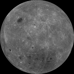
Clementine (spacecraft)

Last updated

Clementine
Clementine lunar.jpg
Mission typeTechnology demonstration
Lunar orbiter
Asteroid probe
Operator BMDO / NASA
COSPAR ID 1994-004A OOjs UI icon edit-ltr-progressive.svg
SATCAT no. 22973
Mission duration115 days
Spacecraft properties
Manufacturer Naval Research Laboratory [1]
Launch mass424 kg [2]
Dry mass227 kilograms (500 lb)
Power1,850 watts
Start of mission
Launch dateJanuary 25, 1994, 16:34:00 (1994-01-25UTC16:34Z) UTC
Rocket Titan II(23)G
Launch site Vandenberg SLC-4W
End of mission
Last contactMay 10, 1995 (1995-05-11) [3]
Orbital parameters
Reference system Selenocentric
Semi-major axis 5,116.0 kilometres (3,178.9 mi)
Eccentricity 0.36
Periselene altitude 2,162 kilometres (1,343 mi)
Aposelene altitude 4,594 kilometres (2,855 mi)
Inclination 90°
Period 300 minutes
Lunar orbiter
Orbital insertionFebruary 21, 1994
Orbital departureMay 3, 1994
Instruments
Charged particle telescope
Ultraviolet/Visible camera
Near-Infrared CCD camera (NIR)
Laser Image Detection and Ranging (LIDAR) system
High-resolution camera (HIRES)
Clementine mission patch.jpg
Clementine mission logo  

Clementine (officially called the Deep Space Program Science Experiment (DSPSE)) was a joint space project between the Ballistic Missile Defense Organization (previously the Strategic Defense Initiative Organization) and NASA, launched on January 25, 1994. Its objective was to test sensors and spacecraft components in long-term exposure to space and to make scientific observations of both the Moon and the near-Earth asteroid 1620 Geographos.

Contents

Results

Observation of the asteroid was not made due to a malfunction in the spacecraft.

The lunar observations included imaging at various wavelengths in the visible as well as in ultraviolet and infrared, laser ranging altimetry, gravimetry, and charged particle measurements. These observations were for the purposes of obtaining multi-spectral imaging of the entire lunar surface, assessing the surface mineralogy of the Moon, obtaining altimetry from 60N to 60S latitude, and obtaining gravity data for the near side. There were also plans to image and determine the size, shape, rotational characteristics, surface properties, and cratering statistics of Geographos.

Spacecraft design

3D model of Clementine Clementine v01.stl
3D model of Clementine

The spacecraft was an octagonal prism 1.88 m high and 1.14 m across [4] with two solar panels protruding on opposite sides parallel to the axis of the prism. A 42-inch-diameter (1,100 mm) high-gain fixed dish antenna was at one end of the prism, and the 489 N thruster at the other end. The sensor openings were all located together on one of the eight panels, 90 degrees from the solar panels, and protected by a single sensor cover.

The spacecraft propulsion system consisted of a monopropellant hydrazine system for attitude control and a bipropellant nitrogen tetroxide and mono-methyl hydrazine system for the maneuvers in space. The bipropellant system had a total Delta-v capability of about 1,900 m/s with about 550 m/s required for lunar insertion and 540 m/s for lunar departure.

Attitude control was achieved with 12 small attitude control jets, two star trackers, and two inertial measurement units. The spacecraft was three-axis stabilized in lunar orbit via reaction wheels with a precision of 0.05 deg in control and 0.03 deg in knowledge. Power was provided by gimbaled, single axis, GaAs/Ge solar panels which charged a 15 A·h, 47 W·h/kg Nihau (Ni-H) common pressure vessel battery.

Spacecraft data processing was performed using a MIL-STD-1750A computer (1.7 MIPS) for safe mode, attitude control, and housekeeping operations, a RISC 32-bit processor (18 MIPS) for image processing and autonomous operations, and an image compression system provided by the French Space Agency CNES. A data handling unit sequenced the cameras, operated the image compression system, and directed the data flow. Data was stored in a 2 Gbit dynamic solid state data recorder.

Mission

Clementine launch Titan 23G launches Clementine.jpg
Clementine launch
Animation of Clementine's trajectory around the Moon from February 19, 1994 to May 3, 1994

.mw-parser-output .legend{page-break-inside:avoid;break-inside:avoid-column}.mw-parser-output .legend-color{display:inline-block;min-width:1.25em;height:1.25em;line-height:1.25;margin:1px 0;text-align:center;border:1px solid black;background-color:transparent;color:black}.mw-parser-output .legend-text{}
Clementine *
Moon Animation of Clementine trajectory around Moon.gif
Animation of Clementine's trajectory around the Moon from February 19, 1994 to May 3, 1994
   Clementine ·  Moon

On January 25, 1994, Clementine was launched from Space Launch Complex 4 West at Vandenberg Air Force Base, California, using a Titan II launch vehicle. The mission had two phases. After two Earth flybys, lunar insertion was achieved approximately one month after launch. Lunar mapping took place over approximately two months, in two parts. The first part consisted of a five-hour elliptical polar orbit with a periapsis of about 400 km at 13 degrees south latitude and an apoapsis of 8,300 km. Each orbit consisted of an 80-minute lunar mapping phase near periapsis and 139 minutes of downlink at apoapsis.

After one month of mapping the orbit was rotated to a periapsis at 13 degrees north latitude, where it remained for one more month. This allowed global imaging and altimetry coverage from 60° south to 60° north, over a total of 300 orbits.

After a Moon to Earth transfer and two more Earth flybys, the spacecraft was to head for 1620 Geographos, arriving three months later for a flyby, with a nominal approach closer than 100 km. Unfortunately, on May 7, 1994, after the first Earth transfer orbit, a malfunction aboard the craft caused one of the attitude control thrusters to fire for 11 minutes, using up its fuel supply and causing Clementine to spin at about 80 rpm. [5] Under these conditions, the asteroid flyby could not yield useful results, so the spacecraft was put into a geocentric orbit passing through the Van Allen radiation belts to test the various components on board.

The mission ended in June 1994 when the power level onboard dropped to a point where the telemetry from the spacecraft was no longer intelligible. However, "because the spacecraft was fortuitously in the correct attitude to power up again, ground controllers were able to briefly regain contact between 20 February and 10 May 1995". [3]

NASA announced on March 5, 1998, that data obtained from Clementine indicated that there is enough water in polar craters of the Moon to support a human colony and a rocket fueling station (see Bistatic Radar Experiment).

Science instruments

Charged Particle Telescope (CPT)

The Charged Particle Telescope (CPT) on Clementine was designed to measure the flux and spectra of energetic protons (380  MeV) and electrons (25500 keV). The primary goals of the investigation were to: (1) study the interaction of the Earth's magnetotail and interplanetary shocks with the Moon; (2) monitor the solar wind in regions far removed from other spacecraft as part of a multimission coordinated study; and, (3) measure the effects of incident particles on the operating ability of the spacecraft solar cells and other sensors.

In order to meet the stringent limit on the mass of the instrument (<1 kg), it was implemented as a single element telescope. The telescope had a 10 degree half-angle field of view. The detector, a silicon surface-barrier type with an area of 100 mm2 and a thickness of 3 mm, was shielded so as to prevent protons below 30 MeV from reaching it from directions other than via the aperture. The aperture was covered by a very thin foil to prevent light impinging on the detector and generating noise. The signal from the detector was broken up into nine channels, the lowest six dedicated to electron detection and the highest three to protons and heavier ions.

Ultraviolet/Visible camera

The Reiner Gamma lunar swirls at 750 nm, as recorded by the Clementine mission Reiner-gamma-clem1.jpg
The Reiner Gamma lunar swirls at 750 nm, as recorded by the Clementine mission

The Ultraviolet/Visible camera (UV/Vis) was designed to study the surfaces of the Moon and the asteroid Geographos at five different wavelengths in the ultraviolet and visible spectrum. The Geographos rendezvous was canceled due to equipment malfunction. This experiment yielded information on the petrologic properties of the surface material on the Moon, as well as giving images useful for morphologic studies and cratering statistics. Most images were taken at low Sun angles, which is useful for petrologic studies but not for observing morphology.

The sensor consisted of a catadioptric telescope with an aperture of 46 mm and fused silica lenses focused onto a coated Thompson CCD camera with a bandpass of 2501000 nm and a six-position filter wheel. The wavelength response was limited on the short wavelength end by the transmission and optical blur of the lens, and on the long end by the CCD response. The CCD was a frame transfer device which allowed three gain states (150, 350, and 1000 electrons/bit). Integration times varied from 140 ms depending on gain state, solar illumination angle, and filter. The filter center wavelengths (and bandpass widths (FWHM)) were 415 nm (40 nm), 750 nm (10 nm), 900 nm (30 nm), 950 nm (30 nm), 1000 nm (30 nm), and a broad-band filter covering 400950 nm. The field of view was 4.2 × 5.6 degrees, translating to a cross-track width of about 40 km at a nominal 400 km lunar altitude. The image array was 288 × 384 pixels. Pixel resolution varied from 100325 m during a single orbit mapping run at the Moon. At Geographos the pixel resolution would have been 25 m at the 100 km closest approach, giving an image size about 7 × 10 km. The camera took twelve images in each 1.3 s image burst, which occurred 125 times over the 80-minute mapping span during each five-hour lunar orbit. the Moon's surface was covered completely during the two-month lunar mapping phase of the mission. The dynamic range was 15,000. The signal-to-noise ratio varied from 2587 depending on the surface albedo and phase angle, with a relative calibration of 1% and an absolute calibration of 15%.

Near-Infrared CCD Camera (NIR)

The Clementine Near-Infrared camera (NIR) was designed to study the surfaces of the Moon and the near-Earth asteroid 1620 Geographos at six different wavelengths in the near-infrared spectrum. This experiment yielded information on the petrology of the surface material on the Moon. The rendezvous with Geographos was canceled due to equipment malfunction.

The camera consisted of a catadioptric lens which focused on a mechanically cooled (to a temperature of 70 K) Amber InSb CCD focal-plane array with a bandpass of 11002800 nm and a six-position filter wheel. The filter center wavelengths (and bandpass widths (FWHM)) were: 1100 nm (60 nm), 1250 nm (60 nm), 1500 nm (60 nm), 2000 nm (60 nm), 2600 nm (60 nm), and 2780 nm (120 nm). The aperture was 29 mm with a focal length of 96 mm. The field of view was 5.6 × 5.6 degrees, giving a cross-track width of about 40 km at a nominal 400 km lunar altitude. The Moon had complete mapping coverage during the two-month lunar phase of the mission. The image array is 256 × 256 pixels, and pixel resolution varied from 150500 m during a single orbit mapping run at the Moon. (At Geographos the pixel resolution would have been 40 m at closest approach, giving an image size about 10 × 10 km.) The camera took twelve images in each 1.3 s image burst, which occurred 75 times over the 80 minute mapping span during each five hour lunar orbit. The dynamic range was 15,000. The signal-to-noise ratio varied from 1197 depending on the surface albedo and phase angle, with a relative calibration of 1% and an absolute calibration of 30%. The gain varied from 0.5X to 36X.

Laser Image Detection and Ranging (LIDAR) System

Relief measurements made by LIDAR Moon clementine lidar.jpg
Relief measurements made by LIDAR

The Clementine Laser Image Detection And Ranging (LIDAR) experiment was designed to measure the distance from the spacecraft to a point on the surface of the Moon. This will allow an altimetric map to be made, which can be used to constrain the morphology of large basins and other lunar features, study stress and strain and flexural properties of the lithosphere, and can be combined with gravity to study the density distribution in the crust. The experiment was also designed to measure distances to the surface of Geographos, but this phase of the mission was canceled due to a malfunction.

The LIDAR system consisted of a 180 mJ, 1064 nm wavelength Nd-YAG (Yttrium-Aluminum-Garnet) laser transmitter which transmitted pulses to the lunar surface. The laser produced a pulse with a width less than 10 ns. At 1064 nm wavelength, the pulse had an energy of 171 mJ with a divergence less than 500 microrad. At 532 nm, it had a 9 mJ pulse with a 4 millirad divergence. The reflected pulse travelled through the High-Resolution Camera telescope, where it was split off by a dichroic filter to a silicon avalanche photodiode detector. The detector was a single 0.5 × 0.5 mm cell SiAPD receiver with a field of view of 0.057 square degrees. The laser had a mass of 1250 g, the receiver was housed in the 1120 g HIRES camera. The travel time of a pulse gave the range to the surface. The LIDAR memory could save up to six return detections per laser firing, with a threshold set for the best compromise between missed detections and false alarms. The returns were stored in 39.972 m range bins, equal to the resolution of the 14-bit clock counter. The LIDAR has a nominal range of 500 km, but altimetric data was gathered for altitudes up to 640 km, which allowed coverage from 60 degrees south to 60 degrees north by the end of the lunar phase of the mission. The vertical resolution is 40 m, and the horizontal spot resolution is about 100 m. The across track spacing of the measurements at the equator was about 40 km. One measurement was made each second over a 45-minute period during each orbit, giving an along track spacing of 12 km.

High-Resolution Camera (HIRES)

Clementine star tracker view of the Moon and Venus in the distance ClementineObservesTheMoonSolarCoronaAndVenus.jpg
Clementine star tracker view of the Moon and Venus in the distance

The Clementine High-Resolution Camera consisted of a telescope with an image intensifier and a frame-transfer CCD imager. The imaging system was designed to study selected portions of the surfaces of the Moon and the near-Earth asteroid 1620 Geographos, although the asteroid rendezvous was canceled due to a malfunction. This experiment allowed the detailed study of surface processes on the Moon and, combined with spectral data, allowed high-resolution compositional and geologic studies.

The imager was an intensified Thompson CCD camera with a six position filter wheel. The set of filters consisted of a broad-band filter with a bandpass of 400 to 800 nm, four narrow-band filters with center wavelengths (and bandpass width (FWHM)) of 415 nm (40 nm), 560 nm (10 nm), 650 nm (10 nm), and 750 nm (20 nm), and 1 opaque cover to protect the image intensifier. The field of view was 0.3 x 0.4 degrees, translating to a width of about 2 km at a nominal lunar altitude of 400 km. The image array is 288 × 384 pixels, (pixel size of 23 × 23 micrometers) so the pixel resolution at the Moon was 720 m depending on the spacecraft altitude. (At Geographos the resolution would have been <5 m at closest approach.) The clear aperture was 131 mm and the focal length was 1250 mm. The nominal imaging rate was about 10 frames per second in individual image bursts covering all filters at the Moon. The high resolution and small field of view only allowed coverage of selected areas of the Moon, in the form of either long, narrow strips of a single color or shorter strips of up to four colors. The instrument has a signal to noise ratio of 13 to 41 depending on the albedo and phase angle, with a 1% relative calibration and a 20% absolute calibration, and a dynamic range of 2000.

The telescope of the High-Resolution Camera was shared by the LIDAR instrument. The 1064 nm laser return was split to the LIDAR receiver (an avalanche photodiode detector) using a dichroic filter.

Imagery from the HIRES can be viewed in NASA World Wind software.

Four orthographic views of the Moon
Near sideTrailing sideFar sideLeading side
90°180°270°
Moon PIA00302.jpg Moon PIA00303.jpg Moon PIA00304.jpg Moon PIA00305.jpg
Polar regions (orthographic, centered on pole)
North poleSouth pole
Moon North Pole.jpg Moon South Pole.jpg

Bistatic Radar Experiment

The "Bistatic Radar Experiment", improvised during the mission, was designed to look for evidence of lunar water at the Moon's poles. Radio signals from the Clementine probe's transmitter were directed towards the Moon's north and south polar regions and their reflections detected by Deep Space Network receivers on Earth. Analysis of the magnitude and polarisation of the reflected signals suggested the presence of volatile ices, interpreted as including water ice, in the Moon's surface soils. A possible ice deposit equivalent to a sizeable lake was announced. However, later studies made using the Arecibo radio telescope showed similar reflection patterns even from areas not in permanent shadow (and in which such volatiles cannot persist), leading to suggestions that Clementine's results had been misinterpreted and were probably due to other factors such as surface roughness. [6] [7] [8]

After the lunar mission

Clementine at the Smithsonian Air and Space Museum Clementine lunar orbiter - Smithsonian Air and Space Museum - 2012-05-15.jpg
Clementine at the Smithsonian Air and Space Museum

On May 7, 1994 (UTC), Clementine experienced a computer failure after it left Lunar orbit. [9] The failure caused it to use up its remaining propellant, spinning the spacecraft up to 80 rotations per minute. [9] It was utilized in a geocentric orbit until the end of its mission, but the asteroid trip was aborted May 2. [9]

Artifacts

The engineering model of the Clementine spacecraft hangs in the National Air and Space Museum in Washington, D.C. [10]

Related Research Articles

<span class="mw-page-title-main">SMART-1</span> European Space Agency satellite that orbited the Moon

SMART-1 was a Swedish-designed European Space Agency satellite that orbited the Moon. It was launched on 27 September 2003 at 23:14 UTC from the Guiana Space Centre in Kourou, French Guiana. "SMART-1" stands for Small Missions for Advanced Research in Technology-1. On 3 September 2006, SMART-1 was deliberately crashed into the Moon's surface, ending its mission.

The Lunar Precursor Robotic Program (LPRP) is a NASA program that uses robotic spacecraft to prepare for future crewed missions to the Moon. The program gathers data such as lunar radiation, surface imaging, areas of scientific interest, temperature and lighting conditions, and potential resource identification.

<span class="mw-page-title-main">Advanced Camera for Surveys</span> Installed on HST March 2002

The Advanced Camera for Surveys (ACS) is a third-generation axial instrument aboard the Hubble Space Telescope (HST). The initial design and scientific capabilities of ACS were defined by a team based at Johns Hopkins University. ACS was assembled and tested extensively at Ball Aerospace & Technologies Corp. and the Goddard Space Flight Center and underwent a final flight-ready verification at the Kennedy Space Center before integration in the cargo bay of the Columbia orbiter. It was launched on March 1, 2002, as part of Servicing Mission 3B (STS-109) and installed in HST on March 7, replacing the Faint Object Camera (FOC), the last original instrument. ACS cost US$86 million at that time.

<span class="mw-page-title-main">Wide Field and Planetary Camera 2</span>

The Wide Field and Planetary Camera 2 (WFPC2) is a camera formerly installed on the Hubble Space Telescope. The camera was built by the Jet Propulsion Laboratory and is roughly the size of a baby grand piano. It was installed by servicing mission 1 (STS-61) in 1993, replacing the telescope's original Wide Field and Planetary Camera (WF/PC). WFPC2 was used to image the Hubble Deep Field in 1995, the Engraved Hourglass Nebula and Egg Nebula in 1996, and the Hubble Deep Field South in 1998. During STS-125, WFPC2 was removed and replaced with the Wide Field Camera 3 as part of the mission's first spacewalk on May 14, 2009. After returning to Earth, the camera was displayed briefly at the National Air and Space Museum and the Jet Propulsion Laboratory before returning to its final home at the Smithsonian's National Air and Space Museum.

<span class="mw-page-title-main">Shackleton (crater)</span> Lunar impact crater

Shackleton is an impact crater that lies at the lunar south pole. The peaks along the crater's rim are exposed to almost continual sunlight, while the interior is perpetually in shadow. The low-temperature interior of this crater functions as a cold trap that may capture and freeze volatiles shed during comet impacts on the Moon. Measurements by the Lunar Prospector spacecraft showed higher than normal amounts of hydrogen within the crater, which may indicate the presence of water ice. The crater is named after Antarctic explorer Ernest Shackleton.

<span class="mw-page-title-main">Chandrayaan-1</span> First lunar orbiter of Indias Chandrayaan Programme

Chandrayaan-1 was the first Indian lunar probe under the Chandrayaan programme. It was launched by the Indian Space Research Organisation (ISRO) in October 2008, and operated until August 2009. The mission included an orbiter and an impactor. India launched the spacecraft using a PSLV-XL rocket on 22 October 2008 at 00:52 UTC from Satish Dhawan Space Centre, at Sriharikota, Andhra Pradesh. The mission was a major boost to India's space program, as India researched and developed indigenous technology to explore the Moon. The vehicle was inserted into lunar orbit on 8 November 2008.

<span class="mw-page-title-main">TRACE</span> NASA satellite of the Explorer program

Transition Region and Coronal Explorer was a NASA heliophysics and solar observatory designed to investigate the connections between fine-scale magnetic fields and the associated plasma structures on the Sun by providing high resolution images and observation of the solar photosphere, the transition region, and the solar corona. A main focus of the TRACE instrument is the fine structure of coronal loops low in the solar atmosphere. TRACE is the third spacecraft in the Small Explorer program, launched on 2 April 1998, and obtained its last science image on 21 June 2010, at 23:56 UTC.

<span class="mw-page-title-main">HiRISE</span> Camera on board the Mars Reconnaissance Orbiter

High Resolution Imaging Science Experiment is a camera on board the Mars Reconnaissance Orbiter which has been orbiting and studying Mars since 2006. The 65 kg (143 lb), US$40 million instrument was built under the direction of the University of Arizona's Lunar and Planetary Laboratory by Ball Aerospace & Technologies Corp. It consists of a 0.5 m (19.7 in) aperture reflecting telescope, the largest so far of any deep space mission, which allows it to take pictures of Mars with resolutions of 0.3 m/pixel, resolving objects below a meter across.

<span class="mw-page-title-main">Hinode (satellite)</span> Japanese satellite

Hinode, formerly Solar-B, is a Japan Aerospace Exploration Agency Solar mission with United States and United Kingdom collaboration. It is the follow-up to the Yohkoh (Solar-A) mission and it was launched on the final flight of the M-V rocket from Uchinoura Space Center, Japan on 22 September 2006 at 21:36 UTC. Initial orbit was perigee height 280 km, apogee height 686 km, inclination 98.3 degrees. Then the satellite maneuvered to the quasi-circular Sun-synchronous orbit over the day/night terminator, which allows near-continuous observation of the Sun. On 28 October 2006, the probe's instruments captured their first images.

<span class="mw-page-title-main">Extreme Ultraviolet Explorer</span> NASA satellite of the Explorer program

The Extreme Ultraviolet Explorer was a NASA space telescope for ultraviolet astronomy. EUVE was a part of NASA's Explorer spacecraft series. Launched on 7 June 1992. With instruments for ultraviolet (UV) radiation between wavelengths of 7 and 76 nm, the EUVE was the first satellite mission especially for the short-wave ultraviolet range. The satellite compiled an all-sky survey of 801 astronomical targets before being decommissioned on 31 January 2001.

<span class="mw-page-title-main">Wide Field Camera 3</span> Astronomical camera on the Hubble Space Telescope

The Wide Field Camera 3 (WFC3) is the Hubble Space Telescope's last and most technologically advanced instrument to take images in the visible spectrum. It was installed as a replacement for the Wide Field and Planetary Camera 2 during the first spacewalk of Space Shuttle mission STS-125 on May 14, 2009.

<span class="mw-page-title-main">Lunar Reconnaissance Orbiter</span> NASA robotic spacecraft orbiting the Moon

The Lunar Reconnaissance Orbiter (LRO) is a NASA robotic spacecraft currently orbiting the Moon in an eccentric polar mapping orbit. Data collected by LRO have been described as essential for planning NASA's future human and robotic missions to the Moon. Its detailed mapping program is identifying safe landing sites, locating potential resources on the Moon, characterizing the radiation environment, and demonstrating new technologies.

JunoCam is the visible-light camera/telescope onboard NASA's Juno spacecraft currently orbiting Jupiter. The camera is operated by the JunoCam Digital Electronics Assembly (JDEA). Both the camera and JDEA were built by Malin Space Science Systems. JunoCam takes a swath of imaging as the spacecraft rotates; the camera is fixed to the spacecraft, so as it rotates, it gets one sweep of observation. It has a field of view of 58 degrees with four filters.

<span class="mw-page-title-main">Jupiter Icy Moons Explorer</span> European Space Agency spacecraft

The Jupiter Icy Moons Explorer is an interplanetary spacecraft that was launched on 14 April 2023 from Guiana Space Centre in the French Guiana by the European Space Agency (ESA) with Airbus Defence and Space as the main contractor. The mission is planned to study Ganymede, Callisto, and Europa, three of Jupiter's Galilean moons. They are thought to have significant bodies of liquid water beneath their icy surfaces which would make them potentially habitable environments.

<span class="mw-page-title-main">Student Nitric Oxide Explorer</span> NASA satellite of the Explorer program

Student Nitric Oxide Explorer, was a NASA small scientific satellite which studied the concentration of nitric oxide in the thermosphere. It was launched in 1998 as part of NASA's Explorer program. The satellite was the first of three missions developed within the Student Explorer Demonstration Initiative (STEDI) program funded by the NASA and managed by the Universities Space Research Association (USRA). STEDI was a pilot program to demonstrate that high-quality space science can be carried out with small, low-cost free-flying satellites on a time scale of two years from go-ahead to launch. The satellite was developed by the University of Colorado Boulder's Laboratory for Atmospheric and Space Physics (LASP) and had met its goals by the time its mission ended with reentry in December 2003.

<span class="mw-page-title-main">EQUULEUS</span> Japanese nanosatellite

EQUULEUS is a nanosatellite of the 6U CubeSat format that will measure the distribution of plasma that surrounds the Earth (plasmasphere) to help scientists understand the radiation environment in that region. It will also demonstrate low-thrust trajectory control techniques, such as multiple lunar flybys, within the Earth-Moon region using water steam as propellant. The spacecraft was designed and developed jointly by the Japan Aerospace Exploration Agency (JAXA) and the University of Tokyo.

Lunar Ultraviolet Cosmic Imager (LUCI) is a small planned telescope that will be landed on the Moon to scan the sky in near UV wavelengths. It is a technology demonstrator developed by the Indian Institute of Astrophysics, and it was planned to be one of several small payloads to be deployed by the commercial Z-01 lander developed by TeamIndus in partnership with OrbitBeyond. The mission was planned to be launched in 2020 as part of NASA's Commercial Lunar Payload Services (CLPS). On 29 July 2019 OrbitBeyond announced that it would drop out of the CLPS contract with NASA, meaning that the 2020 launch was canceled and it is unknown whether the mission will ever take place.

Ralph (<i>New Horizons</i>)

Ralph is a science instrument aboard the robotic New Horizons spacecraft, which was launched in 2006. Ralph is a visible and infrared imager and spectrometer to provide maps of relevant astronomical targets based on data from that hardware. Ralph has two major subinstruments, LEISA and MVIC. MVIC stands for Multispectral Visible Imaging Camera and is a color imaging device, while LEISA originally stood for Linear Etalon Imaging Spectral Array and is an infrared imaging spectrometer for spaceflight. LEISA observes 250 discrete wavelengths of infrared light from 1.25 to 2.5 micrometers. MVIC is a pushbroom scanner type of design with seven channels, including red, blue, near-infrared (NIR), and methane.

Lunar Trailblazer is a planned small lunar orbiter, part of NASA's SIMPLEx program, that will detect and map water on the lunar surface to determine how its form, abundance, and location relate to geology. Its mission is to aid in the understanding of lunar water and the Moon's water cycle. Lunar Trailblazer is currently slated to launch in early 2024 as a secondary payload on the IM-2 mission. The Principal Investigator (PI) of the mission is Bethany Ehlmann, a professor at Caltech.

References

  1. "Clementine" . Retrieved January 8, 2023.
  2. "Clementine". NASA's Solar System Exploration website. Retrieved November 30, 2022.
  3. 1 2 "Beyond Earth: A Chronicle of Deep Space Exploration". September 20, 2018.
  4. https://www.llnl.gov/sites/www/files/2020-05/clementine-etr-jun-94.pdf
  5. NASA Clementine Project Info
  6. Clementine Bistatic Radar Experiment, NASA
  7. Ice on the Moon, NASA
  8. Ice on the Bone Dry Moon, Paul D. Spudis, December 1996
  9. 1 2 3 "NASA - Clementine". Archived from the original on November 20, 2022. Retrieved December 8, 2013.
  10. "Clementine, Engineering Model" . Retrieved May 24, 2021.

Further reading