Holt Rock, Western Australia

Last updated

Holt Rock
Western Australia
Australia Western Australia location map.svg
Red pog.svg
Holt Rock
Holt Rock, Western Australia
Coordinates 32°40′59″S119°28′01″E / 32.683°S 119.467°E / -32.683; 119.467 Coordinates: 32°40′59″S119°28′01″E / 32.683°S 119.467°E / -32.683; 119.467
Population46 (SAL 2021) [1]
Established1939
Postcode(s) 6355
Elevation323 m (1,060 ft)
Area772.8 km2 (298.4 sq mi)
Location
  • 341 km (212 mi) east south east of Perth
  • 100 km (62 mi) ENE of Lake Grace
LGA(s) Shire of Kulin
State electorate(s) Central Wheatbelt
Federal division(s) O'Connor

Holt Rock is a small town in the Wheatbelt region of Western Australia. It is situated between the towns of Hyden and Varley close to the edge of Lake Hurlstone.

The town is named after the nearby geographical feature that was named by the explorer Frank Hann in 1901. Hann had been on an expedition from Ravensthorpe to Menzies. Hann is thought to have named the rock after the surveyor G.H. Holt who worked in the Lands Department. The townsite was gazetted in 1939. [2]

The rocks serve to provide potable water for the town, with a 1,100-cubic-metre (250,000 imp gal) rock catchment tank built to collect run-off from the rocks. [3]

Economically, the area depends on cropping of cereals, primarily wheat. The town is a receival site for Cooperative Bulk Handling. [4] Bulk bins were established in the town in 1940. [5]

Related Research Articles

<span class="mw-page-title-main">Kalannie, Western Australia</span> Town in the Wheatbelt region of Western Australia

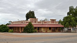
Kalannie is a small town in the Shire of Dalwallinu, in the Wheatbelt region of Western Australia, approximately 259 kilometres (161 mi) north-east of the state capital, Perth.

<span class="mw-page-title-main">Newdegate, Western Australia</span> Town in Western Australia

Newdegate is a townsite in the Great Southern agricultural region, 399 km south-east of Perth and 52 km east of Lake Grace in Western Australia. The townsite was gazetted in 1925 and honours Sir Francis Newdegate, the Governor of Western Australia from 1920 to 1924. The Department of Agriculture and Food operates one of its 13 research stations in the area of Newdegate.

<span class="mw-page-title-main">Perenjori, Western Australia</span> Town in Western Australia

Perenjori is a townsite in the northern agricultural region, 348 kilometres (216 mi) north of Perth and 39 kilometres (24 mi) south-east of Morawa. It is located on the Wongan Hills to Mullewa railway line which was opened in 1915. Perenjori was approved as the name of a siding in April 1913, and later that year the government decided to establish a townsite there. Perenjori townsite was gazetted in 1916.

<span class="mw-page-title-main">Tammin, Western Australia</span> Town in Western Australia

Tammin is a town in the central agricultural region of Western Australia, 184 kilometres (114 mi) east of Perth and midway between the towns of Cunderdin and Kellerberrin on the Great Eastern Highway.

<span class="mw-page-title-main">Burracoppin, Western Australia</span> Town in Western Australia

Burracoppin is a townsite on the Great Eastern Highway, east of Merredin in the Wheatbelt region of Western Australia.

<span class="mw-page-title-main">Moorine Rock, Western Australia</span> Town in Western Australia

Moorine Rock is located in the eastern agricultural region of Western Australia, 347 km east of Perth and 22 km west south west of Southern Cross.

<span class="mw-page-title-main">Hyden, Western Australia</span> Town in Western Australia

The town of Hyden is located 292 kilometres (181 mi) east-southeast of Perth, Western Australia in the Shire of Kondinin. Hyden is home to Wave Rock, Mulka's Cave and Hippos Yawn, all popular local tourist attractions.

<span class="mw-page-title-main">Bruce Rock, Western Australia</span> Town in the Wheatbelt region of Western Australia

Bruce Rock is a town in the eastern Wheatbelt region of Western Australia, approximately 243 kilometres (151 mi) east of Perth and 48 kilometres (30 mi) southwest of Merredin. It is the main town in the Shire of Bruce Rock.

Tarin Rock is a locality, railway siding and rock formation on the Wagin to Lake Grace branch line, located approximately 18 km east of Kukerin in Western Australia.

<span class="mw-page-title-main">Mukinbudin, Western Australia</span> Town in the Wheatbelt region in Western Australia

Mukinbudin is a small town in the north eastern Wheatbelt region of Western Australia, approximately 298 kilometres (185 mi) east of Perth and 80 kilometres (50 mi) north of Merredin near Lake Campion. It is the main town in the Shire of Mukinbudin. At the 2021 Australian census, Mukinbudin had a population of 336.

<span class="mw-page-title-main">Beacon, Western Australia</span> Town in Western Australia

Beacon is a town in Western Australia, in the Shire of Mount Marshall. It is 42 km (26 mi) north of Bencubbin and 333 km (207 mi) northeast of Perth by road.

<span class="mw-page-title-main">Carnamah, Western Australia</span> Town in Western Australia

Carnamah is a town in the Mid West region of Western Australia, about 307 kilometres (191 mi) north of Perth along the Midlands Road. According to 2021 census, the population of the town is 407.

<span class="mw-page-title-main">Nungarin, Western Australia</span> Town in Western Australia

Nungarin is a town located in the north east of the Wheatbelt region of Western Australia, approximately 278 kilometres (173 mi) east of Perth and 39 kilometres (24 mi) north of Merredin. It is the main town in the Shire of Nungarin. At the 2006 census, Nungarin had a population of 142.

<span class="mw-page-title-main">Ardath, Western Australia</span> Town in the Wheatbelt region of Western Australia

Ardath is a small town in the Wheatbelt region of Western Australia 20 kilometres (12 mi) south of the town of Bruce Rock.

<span class="mw-page-title-main">Miling, Western Australia</span> Town in Western Australia

Miling is a small town in the Shire of Moora, 200 kilometres (124 mi) north of Perth, Western Australia. At the 2021 census, it had a population of 101.

<span class="mw-page-title-main">Kulja, Western Australia</span> Town in the Wheatbelt region of Western Australia

Kulja is a small town in the Wheatbelt region of Western Australia. The town is situated along the Bonnie Rock to Burakin Road.

<span class="mw-page-title-main">Latham, Western Australia</span> Town in Western Australia, Australia

Latham is a small town in the Mid West region of Western Australia. It is named after Latham Rock, a large granite rock close to the townsite. The rock was named for an early pastoralist who established a watering place for stock being droved through the area.

<span class="mw-page-title-main">Shackleton, Western Australia</span> Town in the Wheatbelt region in Western Australia

Shackleton is a small town in the Wheatbelt region of Western Australia.

Bowgada is a small town in Western Australia located on the Mullewa Wubin Road 366 kilometres (227 mi) north of Perth in the Mid West region.

<span class="mw-page-title-main">Wialki, Western Australia</span> Town in Western Australia

Wialki is a townsite in the eastern Wheatbelt region of Western Australia. It is situated between Beacon and Bonnie Rock.

References

  1. Australian Bureau of Statistics (28 June 2022). "Holt Rock (Suburb and Locality)". Australian Census 2021 QuickStats. Retrieved 28 June 2022.  OOjs UI icon edit-ltr-progressive.svg
  2. "History of country town names – H". Western Australian Land Information Authority. Retrieved 21 April 2011.
  3. "Lakes Settlement". The West Australian . Perth: National Library of Australia. 25 September 1935. p. 18. Retrieved 22 April 2011.
  4. "CBH receival sites" (PDF). 2011. Archived from the original (PDF) on 18 March 2012. Retrieved 18 April 2011.
  5. "Bulk Wheat Bin". The West Australian . Perth: National Library of Australia. 7 March 1947. p. 18. Retrieved 22 April 2011.