Hoyt Lakes, Minnesota

Last updated

Hoyt Lakes
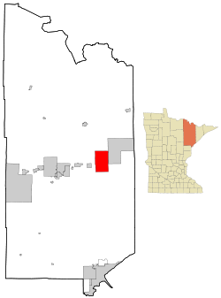
St. Louis County Minnesota Incorporated and Unincorporated areas Hoyt Lakes Highlighted.svg
Location of the city of Hoyt Lakes
within Saint Louis County, Minnesota
Coordinates: 47°31′17″N92°8′14″W / 47.52139°N 92.13722°W / 47.52139; -92.13722
Country United States
State Minnesota
County Saint Louis
Area
[1]
  Total
57.59 sq mi (149.16 km2)
  Land55.91 sq mi (144.81 km2)
  Water1.68 sq mi (4.34 km2)
Elevation
[2]
1,473 ft (449 m)
Population
 (2020)
  Total
2,020
  Density36.13/sq mi (13.95/km2)
Time zone UTC-6 (Central (CST))
  Summer (DST) UTC-5 (CDT)
ZIP codes
55750
Area code 218
FIPS code 27-30302 [3]
GNIS feature ID0661511 [2]
Website HoytLakes.com

Hoyt Lakes is a city in Saint Louis County, Minnesota. The population was 2,020 at the time of the 2020 census. [4]

Contents

Hoyt Lakes was created in 1955 [5] to serve the taconite mine that were operational 1956 - 2008. Ore was transported to Taconite Harbor by the Cliffs Erie Railroad. [6]

Saint Louis County Highway 110 (CR 110) serves as a main route in Hoyt Lakes.

Geography

According to the United States Census Bureau, the city has a total area of 58.09 square miles (150.45 km2); 56.44 square miles (146.18 km2) is land and 1.65 square miles (4.27 km2) is water. [7] Water bodies in the community include Colby Lake and Whitewater Lake.

Demographics

Historical population
CensusPop.Note
1960 3,186
1970 3,63414.1%
1980 3,186−12.3%
1990 2,348−26.3%
2000 2,082−11.3%
2010 2,017−3.1%
2020 2,0200.1%
U.S. Decennial Census [8]

2010 census

As of the census [9] of 2010, there were 2,017 people, 885 households, and 602 families living in the city. The population density was 35.7 inhabitants per square mile (13.8/km2). There were 1,016 housing units at an average density of 18.0 per square mile (6.9/km2). The racial makeup of the city was 98.2% White, 0.5% Native American, and 1.3% from two or more races. Hispanic or Latino of any race were 0.3% of the population.

There were 885 households, of which 23.5% had children under the age of 18 living with them, 55.5% were married couples living together, 7.6% had a female householder with no husband present, 5.0% had a male householder with no wife present, and 32.0% were non-families. 26.8% of all households were made up of individuals, and 13.2% had someone living alone who was 65 years of age or older. The average household size was 2.27 and the average family size was 2.71.

The median age in the city was 49.3 years. 20.2% of residents were under the age of 18; 4% were between the ages of 18 and 24; 21.5% were from 25 to 44; 29.4% were from 45 to 64; and 25.1% were 65 years of age or older. The gender makeup of the city was 49.6% male and 50.4% female.

2000 census

As of the census of 2000, [3] there were 2,082 people, 916 households, and 649 families living in the city. The population density was 37.1 inhabitants per square mile (14.3/km2). There were 995 housing units at an average density of 17.8 per square mile (6.9/km2). The racial makeup of the city was 99.14% White, 0.29% African American, 0.19% Native American, 0.10% Asian, 0.05% from other races, and 0.24% from two or more races. Hispanic or Latino of any race were 0.19% of the population. 22.4% were of Norwegian, 18.6% German, 14.3% Finnish, 7.2% Irish, 6.1% Swedish and 5.2% English ancestry.

There were 916 households, out of which 24.1% had children under the age of 18 living with them, 61.6% were married couples living together, 7.3% had a female householder with no husband present, and 29.1% were non-families. 26.3% of all households were made up of individuals, and 13.3% had someone living alone who was 65 years of age or older. The average household size was 2.27 and the average family size was 2.71.

In the city, the population was spread out, with 19.8% under the age of 18, 6.6% from 18 to 24, 22.6% from 25 to 44, 29.6% from 45 to 64, and 21.3% who were 65 years of age or older. The median age was 46 years. For every 100 females, there were 99.6 males. For every 100 females age 18 and over, there were 96.4 males.

The median income for a household in the city was $39,493, and the median income for a family was $45,603. Males had a median income of $42,000 versus $24,052 for females. The per capita income for the city was $18,882. About 6.6% of families and 8.9% of the population were below the poverty line, including 19.5% of those under age 18 and 5.7% of those age 65 or over.
Related Research Articles

<span class="mw-page-title-main">Lake View, Alabama</span> City in Alabama, United States

Lake View is a city in Alabama, United States, with the majority of the city located within Tuscaloosa County and with a small portion of the city located in Jefferson County. At the 2020 census the population was 3,560, up from 1,943 in 2010. It is part of the Tuscaloosa Metropolitan Statistical Area and the Birmingham metropolitan area. It is located approximately halfway between Tuscaloosa and Birmingham via Interstates 20 and 59.

Ridgeway is a census-designated place (CDP) in Kenai Peninsula Borough, Alaska, United States. At the 2020 census the population was 2,136, up from 2,022 in 2010.

<span class="mw-page-title-main">Hoyt, Kansas</span> City in Jackson County, Kansas

Hoyt is a city in Jackson County, Kansas, United States. As of the 2020 census, the population of the city was 593.

Beals is a town in Washington County, Maine, United States, located on an island opposite Jonesport. The town was named after Manwarren Beal, an early settler. The population was 443 at the 2020 census.

<span class="mw-page-title-main">Amherst Center, Massachusetts</span> Census-designated place in Massachusetts, United States

Amherst Center is a census-designated place (CDP) in the City of Amherst in Hampshire County, Massachusetts, United States. The CDP covers the primary village in town. The population was 19,065 at the 2010 census, out of a total city population of 37,819. It is part of the Springfield, Massachusetts Metropolitan Statistical Area.

<span class="mw-page-title-main">Rolland Township, Michigan</span> Civil township in Michigan, United States

Rolland Township is a civil township of Isabella County in the U.S. state of Michigan. The population was 1,406 at the 2020 census.

Schroeder Township is one of the three townships of Cook County, Minnesota, United States. The population was 179 at the 2020 census. The unincorporated communities of Schroeder and Taconite Harbor are located within the township. The community was named for John Schroeder, a businessperson in the lumber industry.

<span class="mw-page-title-main">Bovey, Minnesota</span> City in Minnesota, United States

Bovey is a city in Itasca County, Minnesota, United States. It is part of Minnesota's Iron Range. The population was 829 at the 2020 census.

Iron Range Township was a township in Itasca County, Minnesota, United States. The population was 649 at the 2010 census.

<span class="mw-page-title-main">Keewatin, Minnesota</span> City in Minnesota, United States

Keewatin is a city in Itasca County, Minnesota, United States. The population was 984 at the 2020 census.

<span class="mw-page-title-main">Taconite, Minnesota</span> City in Minnesota, United States

Taconite is a city in Itasca County, Minnesota, United States. The population was 651 at the 2020 census.

<span class="mw-page-title-main">Silver Bay, Minnesota</span> City in Minnesota, United States

Silver Bay is a city in Lake County, Minnesota, United States. The population was 1,857 at the time of the 2020 census. It is the largest population center in a natural tourism area which includes Tettegouche State Park and the Split Rock Lighthouse. It is a port along Lake Superior for iron ore and has taconite mining facilities of its own.

<span class="mw-page-title-main">Aurora, Minnesota</span> City in Minnesota, United States

Aurora is a city in Saint Louis County, Minnesota, United States. The population was 1,678 at the 2020 census.

<span class="mw-page-title-main">Babbitt, Minnesota</span> City in Minnesota, United States

Babbitt is a city in Saint Louis County, Minnesota, United States. The population was 1,397 at the 2020 census.

Bassett Township is a township in Saint Louis County, Minnesota, United States. The township was named for William Bassett, a businessperson in the lumber industry. The population was 41 at the 2010 census.

Kugler Township is a township in Saint Louis County, Minnesota, United States. The population was 175 at the 2010 census.

<span class="mw-page-title-main">Mountain Iron, Minnesota</span> City in Minnesota, United States

Mountain Iron is a city in Saint Louis County, Minnesota, United States, in the heart of the Mesabi Range. The population was 2,878 at the 2020 census.

Waasa Township is a township in Saint Louis County, Minnesota, United States. The population was 249 at the 2010 census.

White Township is an urban township in Saint Louis County, Minnesota, United States. The population was 3,229 at the 2010 census.

<span class="mw-page-title-main">Hoytville, Ohio</span> Village in Ohio, United States

Hoytville is a village in Wood County, Ohio, United States. The population was 220 at the 2020 census.

References

  1. "2020 U.S. Gazetteer Files". United States Census Bureau. Retrieved July 24, 2022.
  2. 1 2 U.S. Geological Survey Geographic Names Information System: Hoyt Lakes, Minnesota
  3. 1 2 "U.S. Census website". United States Census Bureau . Retrieved January 31, 2008.
  4. "Hoyt Lakes, Minnesota". Census. Retrieved June 1, 2024.
  5. https://www.mnopedia.org/multimedia/hoyt-lakes-under-construction
  6. https://www.mesabitribune.com/news/erie-mining-history-opens-in-hoyt-lakes/article_6ddd3928-50b9-11e8-a253-6f386533463c.html
  7. "US Gazetteer files 2010". United States Census Bureau. Archived from the original on January 25, 2012. Retrieved November 13, 2012.
  8. "Census of Population and Housing". Census.gov. Retrieved June 4, 2015.
  9. "U.S. Census website". United States Census Bureau . Retrieved November 13, 2012.

47°31′11″N92°08′19″W / 47.51972°N 92.13861°W / 47.51972; -92.13861