Countries by land border lengthAntarctica and countries in purple are those without any land border.
This list gives the number of distinct land borders of each country or territory, as well as the neighboring countries and territories. The length of each border is included, as is the total length of each country's or territory's borders.[1]
Countries or territories that are connected only by man-made structures such as bridges, causeways or tunnels are not considered to have land borders. However, borders along lakes, rivers, and other internal waters are considered land borders for the purposes of this article.
Land borders
Country or territory
(Territories without full sovereignty in italics)[lower-alpha 1]
Total length of land borders
No. of distinct land borders
No. of distinct land neighbours
Land border neighbours and border length
(Territories without full sovereignty in italics)[lower-alpha 1] (#) = No. of distinct land boundaries with that country or territory
In addition to the above number of land borders per country, some countries have a man-made bridge, causeway or tunnel between each other without having any proper land border. These artificial land borders are usually less than 50 metres (160ft) long.
1 2 The concept of state sovereignty is somewhat imprecise and there are disagreements about whether certain territories are sovereign. There are currently 195 states that are generally regarded as "fully" sovereign: this includes the 193 member states of the United Nations plus Vatican City and Palestine. Some of these states have under their jurisdiction territories, dependencies, or collectivities that are clearly non-sovereign geographical areas. These territories are generally regarded as being subsumed within the overarching sovereignty of the governing state. For example, the United Kingdom holds sovereignty over the territory of Gibraltar, even though Gibraltar is not considered to be part of the United Kingdom. There are a few territories in the world that are neither clearly sovereign nor clearly subsumed under another state's sovereignty. Often, these territories have declared themselves to be sovereign, but they are either not widely recognized as such or lack some of the necessary conditions for sovereign statehood. In these cases, explanatory footnotes indicate how the territory is treated for the purposes of this list.
↑ Land border lengths will vary depending on the scale by which they are measured, and therefore these figures without a source accompanied by an explanation of how they were measured and at what scale makes comparisons impossible; for more information see coastline paradox.
1 2 3 4 5 If Kosovo is considered part of Serbia, some numbers in the table would be reduced by one (e.g., when a state borders both Serbia and Kosovo). Other numbers would remain the same (e.g., when a state borders Kosovo but not Serbia).
1 2 225km (140mi) via Angola's discontiguous Cabinda Province.
1 2 5,150km (3,200mi) via the long continental border and 150km (93mi) via the border on Tierra del Fuego.
1 2 3 566km (352mi) with Azerbaijan-proper and 221km (137mi) with the Nakhchivanenclave. Additionally, in Armenia, there exist three Azerbaijani enclaves: Barxudarlı, Yuxarı Əskipara and Karki (located north of the region of Nakhchivan) Reciprocally, there exists one Armenian enclave, a village called Artsvashen in north-western Azerbaijan. This makes a total of 6 separate borders, including the 2 major borders.
↑ On the India-Bangladesh border in the Indian district of Cooch-Behar, before 1 August 2015, there were 92 Bangladeshi exclaves, with a total area of 47.7km2 (18.4sqmi). Similarly, there were 106 Indian exclaves inside Bangladesh, with a total area of 69.5km2 (26.8sqmi). Twenty-one of the Bangladeshi exclaves were within Indian exclaves, and three of the Indian exclaves were within Bangladeshi exclaves. The largest Indian exclave, Balapara Khagrabari, surrounded a Bangladeshi exclave, Upanchowki Bhajni, which itself surrounded an Indian exclave called Dahala Khagrabari, of less than one hectare. These 198 exclave borders plus the main border gave a total of 199 sections of border. Today the only remaining exclave is the Bangadeshi exclave of Dahagram-Angarpota. ( "The end of the enclaves". The Economist. September 7, 2011.)
1 2 3 Germany has a group of 5 enclaves created by the Vennbahn railway trackbed between the towns of Roetgen and Monschau (south of Aachen) that was granted Belgian sovereignty. Belgium therefore has 5 borders with these exclaves and one border with the rest of Germany.
1 2 3 4 The town of Baarle in the southern Netherlands is made up of the municipality of Baarle-Hertog, a group of 22 Belgian enclaves within the Netherlands; and of the Dutch municipality of Baarle-Nassau, which itself has one enclave in the main body of Belgium and 7 counter-enclaves inside two of the Belgian enclaves. There are therefore 30 separate enclave border sections, plus the main border for a total of 31 distinct sections.
1 2 This territory is not sovereign but is an overseas department and an overseas region of France. As such, it is sovereign French territory that is an integral part of the French Republic.
↑ For information on the Republic of China, see the listing in this table under "Taiwan".
1 2 3 Cuba has a 29km (18mi) border with the United States Naval Base at Guantanamo Bay. However, the naval base is sovereign Cuban territory and subject to a 1903 treaty is leased perpetually by the U.S. government; therefore, this does not constitute an international border.
1 2 3 4 Akrotiri shares one border with Cyprus. Dhekelia shares one main boundary with Cyprus, but there are three separate enclaves of Cyprus within the main Dhekelia–Cyprus border, which creates three additional borders.
↑ This territory is not sovereign but is a British Overseas Territory. Its territory constitutes part of the sovereign territory of the United Kingdom but strictly speaking is not part of the United Kingdom itself.
1 2 3 4 5 In 1988, the Palestinian Liberation Organization declared as sovereign the State of Palestine. Palestinian sovereignty is recognized by 135 countries, and it has observer status at the United Nations. The State of Palestine consists of the West Bank and the Gaza Strip. In this list, for purposes of counting bordering states, Palestine is considered to be a single sovereign entity.
1 2 3 The town of Llívia is a Spanish exclave situated inside French territory. France has one border with it and two sections of border with the rest of Spain (separated by Andorra).
↑ Hong Kong is not sovereign but since 1997 has been a Special Administrative Region of the People's Republic of China. Hong Kong has a high degree of autonomy, including separate passports and a defined international boundary within China, but it is not considered a separate sovereign state for the purposes of this list.
1 2 Campione d'Italia is enclaved in the canton of Ticino, Switzerland, although in practice it is administered as part of Switzerland. It is part of Swiss customs, uses the Swiss franc, its inhabitants have to pay income tax to Italy, though in a reduced measure, and it is under Italian sovereignty. Switzerland therefore has one border with it and one border with the rest of Italy.
1 2 The Tajik village of Vorukh, along with another small piece of land near Kairagach are embodied in Kyrgyz land. There are therefore 3 sections of border between the two countries.
1 2 Barak, a small Kyrgyz village, is surrounded by Uzbekistan. Reciprocally, the Uzbek towns of So'x (39°58′N71°08′E / 39.967°N 71.133°E / 39.967; 71.133) and Shohimardon as well as the two tiny territories of Qal'acha and Khalmion (north of So'x) are all surrounded by Kyrgyz territory. There are therefore 5 enclave borders in addition to the main Kyrgyz/Uzbek border for a total of 6.
↑ Macau is not sovereign but since 1999 has been a Special Administrative Region of the People's Republic of China. Macau has a high degree of autonomy, including separate passports and a defined international boundary within China, but it is not considered a separate sovereign state for the purposes of this list.
↑ This territory is not sovereign but is an autonomous region of Portugal. Its territory constitutes a constituent part of the sovereign territory of Portugal.
↑ In May 1992, South Ossetia declared independence from Georgia. This declaration is only recognized by 3 UN member countries. In April 2008, the United Nations Security Council unanimously passed Resolution 1808 that reaffirmed "the commitment of all Member States to the sovereignty, independence and territorial integrity of Georgia within its internationally recognized borders".
1 2 The Tajik village of Sarvan is in Uzbek territory. Uzbekistan has one border with it, and another with the rest of Tajikistan.
↑ The irregular border on Märket is 420m (1,380ft). Artificial land borders such as the 0.1 m (4 in) border poles in the water at Tornio are not counted.
Related Research Articles
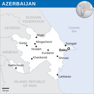
Azerbaijan is a country in the Caucasus region, situated at the juncture of Eastern Europe and West Asia. Three physical features dominate Azerbaijan: the Caspian Sea, whose shoreline forms a natural boundary to the east; the Greater Caucasus mountain range to the north; and the extensive flatlands at the country's center. About the size of Portugal or the US state of Maine, Azerbaijan has a total land area of approximately 86,600 km², less than 1% of the land area of the former Soviet Union. Of the three Transcaucasian states, Azerbaijan has the greatest land area. Special administrative subdivisions are the Nakhchivan Autonomous Republic, which is separated from the rest of Azerbaijan by a strip of Armenian territory, and the Nagorno-Karabakh Autonomous Region, entirely within Azerbaijan. The status of Nagorno-Karabakh is disputed by Armenia, but is internationally recognized as territory of Azerbaijan.
Armenia is a landlocked country in the South Caucasus region of the Caucasus. The country is geographically located in West Asia, within the Armenian plateau. Armenia is bordered on the north and east by Georgia and Azerbaijan and on the south and west by Iran, Azerbaijan's exclave Nakhchivan, and Turkey.
The transport in Azerbaijan involves air traffic, waterways and railroads. All transportation services in Azerbaijan except for oil and gas pipelines are regulated by the Ministry of Transportation of Azerbaijan Republic.
Baarle-Nassau is a municipality and town in the southern Netherlands, located in the province of North Brabant. It had a population of 6,899 in 2019. The town is the site of a complicated borderline between Belgium and the Netherlands: it encloses 22 small exclaves of the Belgian town Baarle-Hertog, of which the two largest contain seven counter-enclaves of Baarle-Nassau, and the main body of Belgium contains another.
Baarle-Hertog is a Flemish municipality of Belgium, much of which consists of a number of small Belgian enclaves fully surrounded by the Netherlands.
A landlocked country is a country that does not have territory connected to an ocean or whose coastlines lie solely on endorheic basins. Currently, there are 44 landlocked countries, two of them doubly landlocked, and three landlocked de facto states in the world. Kazakhstan is the world's largest landlocked country, while Ethiopia is the world's most populous landlocked country.
Nahwa is a territory that forms part of the Emirate of Sharjah in the United Arab Emirates. It is a counter-enclave within the Omani territory of Madha, which is itself an exclave of Oman and an enclave within the United Arab Emirates.
The India–Bangladesh enclaves, also known as the Chiṭmahals and sometimes called Pasha enclaves, were the enclaves along the Bangladesh–India border, in Bangladesh and the Indian states of West Bengal, Tripura, Assam and Meghalaya. The main body of Bangladesh contained 102 Indian enclaves, which in turn contained 21 Bangladeshi counter-enclaves, one of which contained Dahala Khagrabari, an Indian counter-counter-enclave, the world's only third-order enclave when it existed. The Indian mainland contained 71 Bangladeshi enclaves, which in turn contained 3 Indian counter-enclaves. A joint census in 2010 found 51,549 people who were residing in these enclaves: 37,334 in Indian enclaves within Bangladesh and 14,215 in Bangladeshi enclaves within India.
Baarle is a village whose territory is divided into a patchwork of Belgian and Dutch territories. The Belgian parts of the village are called Baarle-Hertog and the Dutch elements are called Baarle-Nassau. The Belgian part includes 16 exclaves within Dutch territory. The exclaves, in turn, surround seven Dutch areas. Belgian territory also surrounds an eighth Dutch area near Ginhoven. In 1995, the border was finalized to include a formerly neutral grassland. Baarle also includes a quadripoint shared by two of the exclaves.
An enclave is a territory that is entirely surrounded by the territory of only one other state or entity. An enclave can be an independent territory or part of a larger one. Enclaves may also exist within territorial waters. Enclave is sometimes used improperly to denote a territory that is only partly surrounded by another state. Enclaves that are not part of a larger territory are not exclaves, for example Vatican City and San Marino and Lesotho are enclaved sovereign states.
A quadripoint is a point on Earth where four distinct political territories meet. The territories can be of different types, such as national and provincial. In North America, several such places are commonly known as Four Corners. Several examples exist throughout the world that use other names.
The Vennbahn is a former railway line that was built partly across what was then German territory by the Prussian state railways. It is now entirely in Belgium, because the trackbed of the line, as well as the stations and other installations, were made provisional Belgian territory in 1919 under an article of the Treaty of Versailles.
The Treaty of Maastricht, signed in 1843 by Belgium and the Netherlands four years after the Treaty of London established Belgian independence, finally settled the border between the two countries.
The following outline is provided as an overview of and topical guide to Azerbaijan:
A territory is an area of land, sea, or space, belonging or connected to a particular country, person, or animal.
The Wire of Death was a lethal electric fence created by the German military to control the Dutch–Belgian frontier after the occupation of Belgium during the First World War.
The Borders of Azerbaijan define the land and maritime borders of Azerbaijan. Azerbaijan has international land borders with 5 states.
The Belgium–Netherlands border separates Belgium and the Netherlands and is 450 km (280 mi) long.
Belgium shares borders with France, Germany, Luxembourg and the Netherlands. Belgium became de facto independent from the United Kingdom of the Netherlands in 1830. Its borders were formalized between 1839 and 1843. Over the years there have been various adjustments, notably after the Treaty of Versailles (1919) when some territory was transferred to Luxembourg. There remain enclaves of Germany and the Netherlands within Belgium and enclaves of Belgium within the Netherlands.
This page is based on this Wikipedia article Text is available under the CC BY-SA 4.0 license; additional terms may apply. Images, videos and audio are available under their respective licenses.