
Azerbaijan is a country in the Caucasus region, situated at the juncture of Eastern Europe and West Asia. Three physical features dominate Azerbaijan: the Caspian Sea, whose shoreline forms a natural boundary to the east; the Greater Caucasus mountain range to the north; and the extensive flatlands at the country's center. About the size of Portugal or the US state of Maine, Azerbaijan has a total land area of approximately 86,600 km2, less than 1% of the land area of the former Soviet Union. Of the three Transcaucasian states, Azerbaijan has the greatest land area. Special administrative subdivisions are the Nakhchivan Autonomous Republic, which is separated from the rest of Azerbaijan by a strip of Armenian territory, and the Nagorno-Karabakh Autonomous Region, entirely within Azerbaijan. The status of Nagorno-Karabakh is disputed by Armenia, but is internationally recognized as territory of Azerbaijan.

Brunei is a country in Southeast Asia, bordering the South China Sea and East Malaysia. Its geographical coordinates are 4°30′N114°40′E. The country is small with a total size of 5,765 km2 (2,226 sq mi). It is larger in size than Trinidad and Tobago. It is close to vital sea lanes through the South China Sea linking the Indian and Pacific Oceans. The country has two parts physically separated by Malaysia, making it almost an enclave within Malaysia.

Kazakhstan is located in Central Asia, with a small portion in Eastern Europe. With an area of about 2,724,900 square kilometers (1,052,100 sq mi) Kazakhstan is more than twice the combined size of the other four Central Asian states and 60% larger than Alaska. The country borders Turkmenistan, Uzbekistan, and Kyrgyzstan to the south; Russia to the north; Russia and the Caspian Sea to the west; and China's Xinjiang Uygur Autonomous Region to the east.
Kyrgyzstan is a landlocked nation in Central Asia, with an area of 199,951 km². The national territory extends about 900 km (560 mi) from east to west and 410 km (250 mi) from north to south.
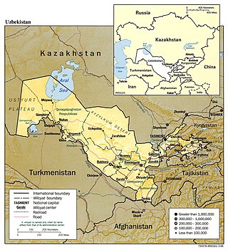
Uzbekistan is a country in Central Asia, located north of Turkmenistan and Afghanistan. With an area of approximately 448,900 square kilometers, Uzbekistan stretches 1,425 km (885 mi) from west to east and 930 km (580 mi) from north to south. It borders Turkmenistan to the southwest, Kazakhstan to the north and Tajikistan and Kyrgyzstan to the south and east. Uzbekistan also has four small exclaves in Turkmenistan.

Irrigation is the practice of applying controlled amounts of water to land to help grow crops, landscape plants, and lawns. Irrigation has been a key aspect of agriculture for over 5,000 years and has been developed by many cultures around the world. Irrigation helps to grow crops, maintain landscapes, and revegetate disturbed soils in dry areas and during times of below-average rainfall. In addition to these uses, irrigation is also employed to protect crops from frost, suppress weed growth in grain fields, and prevent soil consolidation. It is also used to cool livestock, reduce dust, dispose of sewage, and support mining operations. Drainage, which involves the removal of surface and sub-surface water from a given location, is often studied in conjunction with irrigation.

Rwanda is located in East Africa, to the east of the Democratic Republic of the Congo, at the co-ordinates 2°00′S30°0′E.
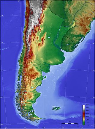
The geography of Argentina is heavily diverse, consisting of the Andes Mountains, pampas, and various rivers and lakes. Bordered by the Andes in the west and the South Atlantic Ocean to the east, its neighbouring countries are Chile to the west, Bolivia and Paraguay to the north, and Brazil and Uruguay to the northeast.

Bangladesh is a densely populated, low-lying, mainly riverine country located in South Asia with a coastline of 580 km (360 mi) on the northern littoral of the Bay of Bengal. The delta plain of the Ganges (Padma), Brahmaputra (Jamuna), and Meghna Rivers and their tributaries occupy 79 percent of the country. Four uplifted blocks occupy 9 percent and steep hill ranges up to approximately 1,000 metres (3,300 ft) high occupy 12 percent in the southeast and in the northeast. Straddling the Tropic of Cancer, Bangladesh has a tropical monsoon climate characterised by heavy seasonal rainfall, high temperatures, and high humidity. Natural disasters such as floods and cyclones accompanied by storm surges periodically affect the country. Most of the country is intensively farmed, with rice the main crop, grown in three seasons. Rapid urbanisation is taking place with associated industrial and commercial development. Exports of garments and shrimp plus remittances from Bangladeshis working abroad provide the country's three main sources of foreign exchange income.

Central Africa is a subregion of the African continent comprising various countries according to different definitions. Middle Africa is an analogous term used by the United Nations in its geoscheme for Africa and consists of the following countries: Angola, Cameroon, Central African Republic, Chad, Democratic Republic of the Congo, Republic of the Congo, Equatorial Guinea, Gabon, and São Tomé and Príncipe. The United Nations Office for Central Africa also includes Burundi and Rwanda in the region, which are considered part of East Africa in the geoscheme. These eleven countries are members of the Economic Community of Central African States (ECCAS). Six of those countries are also members of the Economic and Monetary Community of Central Africa (CEMAC) and share a common currency, the Central African CFA franc.
These are the international rankings of Pakistan.
Mexico, a classified arid and semi-arid country, has a total land area of 2 million square kilometres, 23% of which is equipped for irrigated agriculture. The agricultural sector plays an important role in the economic development of the country accounting for 8.4 of agricultural gross domestic product (GDP) and employing 23% of the economically active population. Irrigated agriculture contributes about 50% of the total value of agricultural production and accounts for about 70% of agriculture exports. Mexico's government initiated a number of structural reforms in the water sector aimed to introduce modern water management and irrigation.
Irrigation in Brazil has been developed through the use of different models. Public involvement in irrigation is relatively new while private investment has traditionally been responsible for irrigation development. Private irrigation predominates in the populated South, Southeast, and Center-West regions with most of the country’s agricultural and industrial development. In the Northeast region, investments made by the public sector seek to stimulate regional development in an area prone to droughts and with serious social problems. These different approaches have resulted in diverse outcomes. Of the 120 million hectares (ha) that are potentially available for agriculture, only about 3.5 million ha are under irrigation, although estimates show that 29 million ha are suitable for this practice.

Russia, the largest country in the world by area, has international land borders with fourteen sovereign states as well as two narrow maritime boundaries with the United States and Japan. There are also two breakaway states bordering Russia, namely Abkhazia and South Ossetia. The country has an internationally recognized land border running 22,407 kilometres (13,923 mi) in total, and has the second-longest land border of any country in the world, after China.

The environmental impact of irrigation relates to the changes in quantity and quality of soil and water as a result of irrigation and the subsequent effects on natural and social conditions in river basins and downstream of an irrigation scheme. The effects stem from the altered hydrological conditions caused by the installation and operation of the irrigation scheme.
Water resources management in modern Egypt is a complex process that involves multiple stakeholders who use water for irrigation, municipal and industrial water supply, hydropower generation and navigation. In addition, the waters of the Nile support aquatic ecosystems that are threatened by abstraction and pollution. Egypt also has substantial fossil groundwater resources in the Western Desert.
Although it is a country of high annual rainfall, irrigation in Vietnam is widespread. The reason is the uneven distribution of rainwater in space and in time. Irrigation management is mainly dominated by the state whereas there have been certain reforms leading to change during the last years. Awareness rising concerning environmental issues is starting to reach the people in Vietnam as well. Different strategies have been developed within the last decade to deal with environmental problems and mitigate possible impacts of climate change. With the implementation of different management structures taking into account the people's local needs, Vietnam is starting to follow Integrated Water Resources Management principles.

Adherents of Islam constitute the world's second largest and fastest growing major religious grouping, maintaining suggested 2017 projections in 2022. As of 2020, Pew Research Centre (PEW) projections suggest there are a total of 1.9 billion adherents worldwide. Further studies indicate the worldwide spread and percentage growth of Islam, may be attributed to high birth rates followed by a trend of worldwide adoption and conversion to Islam.

Rice production in Myanmar accounts for approximately 43% of total agricultural production in the country, making it the seventh largest producer of rice in the world. Out of 67.6 million hectares of land, 12.8 million are used for cultivation. In 2019 alone, Myanmar accounted for 13,300 million metric tons of milled rice production.
