Mammoth, Pennsylvania

Last updated

Mammoth, Pennsylvania
CDP
Country United States
State Pennsylvania
County Westmoreland
Area
[1]
  Total2.02 sq mi (5.24 km2)
  Land2.02 sq mi (5.24 km2)
  Water0.00 sq mi (0.00 km2)
Population
 (2020) [2]
  Total526
  Density260.14/sq mi (100.45/km2)
Time zone UTC-5 (Eastern (EST))
  Summer (DST) UTC-4 (EDT)
FIPS code 42-46800

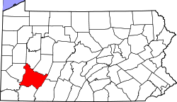
Mammoth is a census-designated place [3] that is located in Mount Pleasant Township, Westmoreland County in the state of Pennsylvania, United States, with its own post office and postal zip code: 15664.

Contents

The community is located just off Pennsylvania Route 982 and is part of the Mount Pleasant Area School District.

Demographics

As of the 2010 census, [4] the population was 525 residents.

Historical population
CensusPop.Note
2020 526
U.S. Decennial Census [5]

Local Attractions

Mammoth is home to Mammoth Park, a 408-acre park that features a stocked freshwater lake, recreational areas, several playgrounds, and pavilions. [6] The park is home to the Giant Slide Complex, a pair of 100-foot long slides perched on a climbable rock wall. The complex has been embroiled in lawsuits every year, but remains open as of 2024. [7] In the spring, the annual Mammoth Fest festival featuring vendor booths and children's rides is held at the park. [8]

Also located in Mammoth is the Mount Pleasant Township Municipal Building. [9]

Despite its small population, Mammoth is home to several businesses, including Citizens Telephone Company of Kecksburg which first opened in 1906 to bring telephone services to the rural miners and farmers who lived in the area. [10]

Mammoth is situated in close proximity to the site of the 1965 Kecksburg UFO incident in which many local residents claimed to have witnessed an object streak across the sky and crash-land in the woods of neighboring Kecksburg, PA. The government response to the incident has led many to speculate what the object was, leading to many theories such as a UFO or Russian satellite. [11]

Mining

Known as the infamous Mammoth Mine Disaster, on January 27, 1891, an explosion tore through Mammoth No. 1 Mine owned at the time by H.C. Frick Coke Company. [12] Newspapers reported that firedamp was ignited by a miner's oil lamp, causing the explosion. [13] All 110 miners who entered that day were killed instantly. [13]

The workers killed in the mine explosion were buried in a mass grave in St. John's Cemetery in Scottdale, Pennsylvania. In 2000, the Pennsylvania Historical and Museum Commission erected a historical marker at the burial site commemorating the Mammoth Mine Explosion. [14]

The sealed-off entrance to the mine can still be seen today. [15] It is situated behind the Mount Pleasant Township Municipal Building, which once served as the former boiler house and lamp house for the mine. It is the only building from the mining operation still in existence. [16] Many of the patch homes once owned by the miners and their families are still occupied today throughout Mammoth and along Poker Road. [16]

Related Research Articles

<span class="mw-page-title-main">Westmoreland County, Pennsylvania</span> County in Pennsylvania, United States

Westmoreland County is a county in the Commonwealth of Pennsylvania, United States, located in the Pittsburgh Metropolitan Statistical Area. As of the 2020 census, the population was 354,663. The county seat is Greensburg and the most populous community is Hempfield Township. It is named after Westmorland, a historic county of England. The county is part of the Southwest Pennsylvania region of the state.

<span class="mw-page-title-main">Plum, Pennsylvania</span> Borough in Pennsylvania, United States

Plum is a borough in Allegheny County, Pennsylvania, United States. The population was 27,144 at the 2020 census. A suburb of the Pittsburgh metropolitan area, it is located northeast of the city in what is commonly referred to as the East Hills suburbs.

<span class="mw-page-title-main">Hempfield Township, Westmoreland County, Pennsylvania</span> Township in Pennsylvania, United States

Hempfield Township is a township in Westmoreland County, Pennsylvania, United States. The population was 41,585 at the 2020 census, making it the largest suburb in the Pittsburgh Metropolitan Area by population. Its name is derived from Hempfield in Lancaster County, which was formed in 1729 and is named after the hemp fields in the area.

<span class="mw-page-title-main">Mount Pleasant, Pennsylvania</span> Borough in Pennsylvania, United States

Mount Pleasant is a borough in Westmoreland County, Pennsylvania, United States. It stands 45 miles (72 km) southeast of Pittsburgh. As of the 2020 census, the borough's population was 4,245.

<span class="mw-page-title-main">Mount Pleasant Township, Westmoreland County, Pennsylvania</span> Township in Pennsylvania, United States

Mount Pleasant Township is a township in Westmoreland County, Pennsylvania, United States. As of the 2020 census, the township population was 10,119. Mount Pleasant Township should not be confused with the Borough of Mount Pleasant, which is a separate municipality and comprises the town of that name.

<span class="mw-page-title-main">Unity Township, Pennsylvania</span> Township in Pennsylvania, United States

Unity Township is a township in Westmoreland County, Pennsylvania, United States. The population was 21,724 at the 2020 census, a decline of approximately 4% compared to the 2010 census.

The Connellsville Coalfield is located in Fayette County and Westmoreland County, Pennsylvania, between the city of Latrobe and the small borough of Smithfield. It is sometimes known as the Connellsville Coke Field. This is because the section of the Pittsburgh coal seam here was famous as one of the finest metallurgical coals in the world. It is locally known as the Connellsville coal seam, but is a portion of the Pittsburgh seam.

Kecksburg is an unincorporated community in Mount Pleasant Township, Westmoreland County, Pennsylvania, United States. Located in a heavily wooded area along PA Route 982, it is approximately thirty miles southeast of Pittsburgh at an elevation of 1,209 feet.

<span class="mw-page-title-main">Ruffs Dale, Pennsylvania</span> Unincorporated community in Pennsylvania, United States

Ruffs Dale, also spelled Ruffsdale, is an unincorporated community in East Huntingdon Township, Westmoreland County, Pennsylvania United States. It is located approximately forty miles from Pittsburgh. Ruffs Dale has its own post office, with zip code 15679, located at 875 State Route 31.

<span class="mw-page-title-main">Darr Mine disaster</span> 1907 mining accident in Pennsylvania

The Darr Mine disaster at Van Meter, Rostraver Township, Westmoreland County, Pennsylvania, near Smithton, killed 239 men and boys on December 19, 1907. It ranks as the worst coal mining disaster in Pennsylvanian history. Many victims were of immigrants from central Europe, including Rusyns, Hungarians, Austrians, Germans, Poles and Italians.

<span class="mw-page-title-main">Pennsylvania Route 981</span> State highway in Westmoreland County, Pennsylvania, US

Pennsylvania Route 981 is a state highway which runs 50.4 miles (81.1 km) across Westmoreland County, in southwestern Pennsylvania, United States. The highway begins at PA 51 in Rostraver Township, Pennsylvania, and runs northward across Westmoreland County, passing through the towns of Mount Pleasant, Latrobe, and New Alexandria before ending at PA 819 in Salina.

<span class="mw-page-title-main">Norvelt, Pennsylvania</span> Census-designated place in Pennsylvania, United States

Norvelt is a census-designated place in Mount Pleasant Township, Westmoreland County, Pennsylvania, United States, founded in 1934 as Westmoreland Homesteads. In 1937 it was renamed to honor Eleanor Roosevelt. The community was part of the Calumet-Norvelt CDP for the 2000 census, but was split into the two separate communities of Calumet and Norvelt for the 2010 census. Calumet was a typical company town, locally referred to as a "patch" or "patch town", built by a single company to house coal miners as cheaply as possible. On the other hand, Norvelt was created during the Great Depression by the federal government of the United States as a model community, intended to increase the standard of living of laid-off coal miners. Award winning writer Jack Gantos was born in the village and wrote two books about it

Calumet is a census-designated place in Mount Pleasant Township, Westmoreland County, Pennsylvania, United States. Although the United States Census Bureau included it as a census-designated place with the nearby community of Norvelt for the 2000 census, they are in reality two very different communities, each reflecting a different chapter in how the Great Depression affected rural Pennsylvanians. As of the 2010 census, Calumet-Norvelt was divided into two separate CDPs officially. Calumet was a typical "patch town," another name for a coal town, built by a single company to house coal miners as cheaply as possible. The closing of the Calumet mine during the Great Depression caused enormous hardship in an era when unemployment compensation and welfare payments were nonexistent. On the other hand, Norvelt was created during the depression by the US federal government as a model community, intended to increase the standard of living of laid-off coal miners.

Standard Shaft is located in Mount Pleasant Township, Westmoreland County, Pennsylvania, United States. It is a community located near Mount Pleasant.

United is located in Mount Pleasant Township, Westmoreland County, Pennsylvania, United States. It is a community located near Norvelt.

<span class="mw-page-title-main">Pennsylvania House of Representatives, District 59</span> American legislative district

The 59th Pennsylvania House of Representatives District is located in southwest Pennsylvania and has been represented by Leslie Rossi since 2021.

<span class="mw-page-title-main">Morewood massacre</span>

The Morewood massacre was an armed labor-union conflict in Morewood, Pennsylvania, in Westmoreland County, west of the present-day borough Mount Pleasant in 1891.

<span class="mw-page-title-main">Pleasant Unity, Pennsylvania</span> Unincorporated community in Pennsylvania, United States

Pleasant Unity is an unincorporated community in a rural section of Unity Township, Westmoreland County, Pennsylvania, United States. It is located at the junction of state routes 130 and 981, 6.3 miles (10.1 km) southeast of Greensburg.

<span class="mw-page-title-main">Mammoth Mine disaster</span>

The Mammoth Mine disaster or Frick Mine explosion occurred on January 27, 1891 just after 9:00 AM in the Mammoth No. 1 mine in Mount Pleasant Township, Westmoreland County, Pennsylvania. Newspapers reported that firedamp was ignited by a miner's oil lamp, resulting in the deaths of 109 men and boys. Most of the miners were not killed by the force of the explosion, but rather were suffocated by the effects of afterdamp.

References

  1. "ArcGIS REST Services Directory". United States Census Bureau. Retrieved October 12, 2022.
  2. "Census Population API". United States Census Bureau. Retrieved October 12, 2022.
  3. Mammoth 2010 Census Information
  4. 2010 US Census
  5. "Census of Population and Housing". Census.gov. Retrieved June 4, 2016.
  6. "Mammoth Park | Westmoreland County, PA - Official Website". www.co.westmoreland.pa.us. Retrieved September 27, 2019.
  7. "Mammoth Park Giant Slide | Westmoreland County, PA - Official Website". www.co.westmoreland.pa.us. Retrieved September 27, 2019.
  8. "Mammoth Fest | Westmoreland County, PA - Official Website". www.co.westmoreland.pa.us. Retrieved September 27, 2019.
  9. "Home". Mt. Pleasant Township. Retrieved September 27, 2019.
  10. "Family-owned Citizens Fiber in Mt. Pleasant Township strives to be among 1st in Pennsylvania to offer gigabit internet | TribLIVE.com". archive.triblive.com. Retrieved September 27, 2019.
  11. "The Kecksburg UFO Crash | HISTORY". play.history.com. Retrieved February 24, 2020.
  12. "Mammoth Mine Explosion Historical Marker". explorepahistory.com. Retrieved February 25, 2020.
  13. 1 2 ""Over One Hundred Killed" (PDF)" (PDF). New York Times. January 27, 1891.
  14. "Mammoth Mine Explosion Historical Marker". www.hmdb.org. Retrieved April 5, 2020.
  15. "Mammoth Mine portal to history opens in Mt. Pleasant Township | TribLIVE.com". archive.triblive.com. Retrieved April 5, 2020.
  16. 1 2 Muller, Edward K. (1994). Westmoreland County, Pennsylvania: An Inventory of Historic Engineering and Industrial Sites. National Park Service. pp. 56–59.