
Bastion Peak is a 2,994-metre (9,823 ft) mountain summit located on the shared border of Jasper National Park in Alberta, and Mount Robson Provincial Park in British Columbia, Canada. It is situated in the Tonquin Valley in the Canadian Rockies. It was named in 1916 by Édouard-Gaston Deville because it has an appearance similar to that of a bastion on a castle. Its nearest higher peak is Turret Mountain, 1.6 km (0.99 mi) to the west, and its greater parent is Mount Geikie 3 km (1.9 mi) to the west.
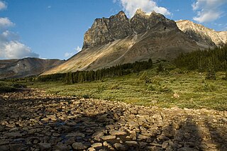
Dungeon Peak is a 3,129-metre (10,266 ft) mountain summit located on the shared border of Jasper National Park in Alberta, and Mount Robson Provincial Park in British Columbia, Canada. Dungeon Peak is part of The Ramparts in the Tonquin Valley. The descriptive name was applied in 1916 by Morrison P. Bridgland (1878-1948), a Dominion Land Surveyor who named many peaks in Jasper Park and the Canadian Rockies. The mountain's name was made official in 1935 by the Geographical Names Board of Canada.

Angle Peak is a 2,910-metre (9,547 ft) mountain summit located in Jasper National Park, in the Canadian Rockies of Alberta, Canada. Angle Peak was named for the fact it stands where the ridge makes a bend. The descriptive name was applied in 1916 by Morrison P. Bridgland (1878-1948), a Dominion Land Surveyor who named many peaks in Jasper Park and the Canadian Rockies. The mountain's name was made official in 1935 by the Geographical Names Board of Canada. The mountain is situated in the Tonquin Valley, with Angle Glacier on its north slope, Alcove Mountain to its immediate west, The Ramparts 10 km (6.2 mi) to the northwest, and Mount Edith Cavell 12 km (7.5 mi) to the northeast.

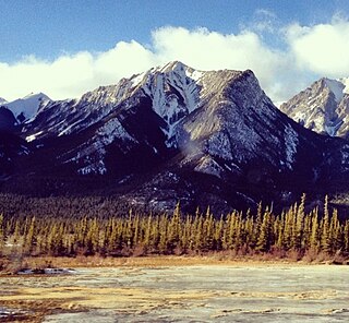
Chetamon Mountain is a 2,606-metre (8,550-foot) mountain summit located in Jasper National Park, in the De Smet Range of the Canadian Rockies in Alberta, Canada. The peak is situated 18 kilometres (11 mi) north of the municipality of Jasper, in the Athabasca Valley and is visible from Highway 16 and the Canadian. Its nearest higher peak is Cliff Mountain, 3.5 km (2.2 mi) to the northwest.
Coronach Mountain is a 2,462-metre (8,077 ft) mountain summit located in Jasper National Park of Alberta, Canada. It is situated in the Bosche Range of the Canadian Rockies. The mountain was named in 1916 by Morrison P. Bridgland, who was inspired by the howling of nearby coyotes and applied the name Coronach, the Scottish Gaelic word for funeral dirge. Bridgland (1878–1948) was a Dominion Land Surveyor who named many peaks in Jasper Park and the Canadian Rockies. The mountain's name was officially adopted in 1956 by the Geographical Names Board of Canada. Its nearest higher peak is Mount Aeolus, 3.5 km (2.2 mi) to the north.
Mount Cumnock is a 2,438 m (7,999 ft) mountain summit located in Jasper National Park of Alberta, Canada. It is situated in the De Smet Range of the Canadian Rockies. Mount Cumnock was named in 1916 by Morrison P. Bridgland after Cumnock, in Scotland. Bridgland (1878-1948) was a Dominion Land Surveyor who named many peaks in Jasper Park and the Canadian Rockies. The mountain's name was officially adopted in 1956 by the Geographical Names Board of Canada. Its nearest higher peak is Mount Haultain, 7.5 km (4.7 mi) to the west.

Gargoyle Mountain is a 2,693-metre (8,835-foot) mountain summit located in Jasper National Park, in the Canadian Rockies of Alberta, Canada. The peak is situated 23 kilometres north of the municipality of Jasper, and is a prominent landmark in the Athabasca Valley visible from Highway 16 and The Canadian. Its nearest higher peak is Cliff Mountain, 5.5 km (3.4 mi) to the west. Gargoyle Mountain was named in 1916 by Morrison P. Bridgland for the fact a stream heads at the mountain, like a gargoyle or spout. Bridgland (1878-1948) was a Dominion Land Surveyor who named many peaks in Jasper Park and the Canadian Rockies. The mountain's name was officially adopted in 1956 by the Geographical Names Board of Canada.

Grisette Mountain is a 2,620-metre (8,600 ft) mountain summit located in Jasper National Park in Alberta, Canada. It is located in the Colin Range, which is a sub-range of the Canadian Rockies. The peak is situated 14 km (8.7 mi) northeast of the municipality of Jasper, and is a prominent landmark in the Athabasca Valley visible from Highway 16 and the Canadian. Its nearest higher peak is Mount Dromore, 2.4 km (1.5 mi) to the east.
Mount Tekarra is a 2,694-metre (8,839-foot) mountain summit located in the Athabasca River valley of Jasper National Park, in the Canadian Rockies of Alberta, Canada. It is situated at the northwest end of the Maligne Range and is visible from Jasper and the Icefields Parkway. The nearest higher neighbor is The Watchtower, 7.0 km (4.3 mi) to the east.

Hawk Mountain is a 2,553-metre (8,376-foot) mountain summit located in Jasper National Park in Alberta, Canada. It is located near the northwest end of the Colin Range, which is a sub-range of the Canadian Rockies. The peak is situated 16 km (9.9 mi) northeast of the municipality of Jasper, and is a prominent landmark in the Athabasca Valley visible from Highway 16 and the Canadian. Its nearest higher peak is Mount Colin, 2.4 km (1.5 mi) to the southeast. Hawk Mountain was named in 1916 by Morrison P. Bridgland for the fact that a hawk was flying near the summit at the time it was named. Bridgland (1878-1948) was a Dominion Land Surveyor who named many peaks in Jasper Park and the Canadian Rockies. The mountain's name was officially adopted in 1956 by the Geographical Names Board of Canada.
Esplanade Mountain is a 2,301-metre (7,549-foot) mountain summit located in Jasper National Park, in the Canadian Rockies of Alberta, Canada. The peak is situated 20 kilometres north of the municipality of Jasper, in the Athabasca Valley and is visible from Highway 16 and the Canadian. Its nearest higher peak is Cliff Mountain, 5.0 km (3.1 mi) to the west. Esplanade Mountain was named in 1916 by Morrison P. Bridgland for its long, flat top resembling an esplanade. Bridgland (1878-1948) was a Dominion Land Surveyor who named many peaks in Jasper Park and the Canadian Rockies. The mountain's name was officially adopted in 1956 by the Geographical Names Board of Canada.

The Whistlers is a 2,470-metre (8,100-foot) mountain summit located in Jasper National Park, in the Trident Range of the Canadian Rockies of Alberta, Canada. The municipality of Jasper is situated 7 kilometres to the northeast. The nearest higher neighbor is Indian Peak, 2.5 km (1.6 mi) to the southwest. The highest and longest aerial tramway in Canada ascends to a lookout at 2,277 meters elevation, still 193 meters below the summit, but a hiking trail continues to the summit. Some of the mountains that can be seen from the top include Mount Robson, Mount Bridgland, Monarch Mountain, Cairngorm, Pyramid Mountain, Hawk Mountain, Mount Colin, Grisette Mountain, Mount Tekarra, Mount Hardisty, Mount Kerkeslin, Marmot Mountain, Terminal Mountain, and Manx Peak.

Morro Peak is a small 1,679-metre (5,509-foot) mountain summit located in Jasper National Park in Alberta, Canada. It is located at the northwest end of the Colin Range, which is a sub-range of the Canadian Rockies. The peak is situated 17 km (11 mi) north of the municipality of Jasper, and is a prominent landmark in the Athabasca Valley visible from Highway 16 and the Canadian. The nearest higher peak is Hawk Mountain, 4.0 km (2.5 mi) to the southeast. Morro Peak was named in 1916 by Morrison P. Bridgland for the Spanish word morro, meaning rounded hill, which is an apt description of it. Bridgland (1878-1948) was a Dominion Land Surveyor who named many peaks in Jasper Park and the Canadian Rockies. The mountain's name was officially adopted in 1956 by the Geographical Names Board of Canada.

Manx Peak is a 3,044-metre (9,987 ft) mountain summit located in Jasper National Park, in the Trident Range of the Canadian Rockies of Alberta, Canada. The town of Jasper is situated 14 kilometres (8.7 mi) to the north-northeast. Circus Valley lies at the south side of the mountain, and the northeast aspect towers above the head of the valley of Whistlers Creek. Its nearest higher peak is Mount Estella, 1.8 km (1.1 mi) to the southwest, and Terminal Mountain lies 2.0 km (1.2 mi) to the east. The peak is composed of sedimentary rock laid down from the Precambrian to the Jurassic periods and pushed east and over the top of younger rock during the Laramide orogeny.

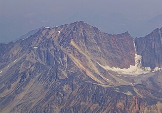
Mount Geikie, pronounced like "geeky", is a 3,298-metre (10,820-foot) mountain summit located in Mount Robson Provincial Park in British Columbia, Canada. Situated 28 km (17 mi) southwest of Jasper near the Tonquin Valley, Mount Geikie is the highest peak of The Ramparts in the Canadian Rockies, one of the most beautiful mountain meccas in the world. Its nearest higher peak is Mount Fraser, 8.0 km (5.0 mi) to the southeast, and the Continental Divide lies 3.0 km (1.9 mi) to the east. Mount Geikie is composed of quartzite of the Cambrian period. This rock was pushed east and over the top of younger rock during the Laramide orogeny. The vertical wall of its north face is over 1,500-metre (4,900-foot) high, and has been compared to the other great north faces of the Canadian Rockies such as North Twin, Alberta, and Kitchener.

Outpost Peak is a 2,880-metre (9,450-foot) double peak mountain located in the Tonquin Valley of Jasper National Park in Alberta, Canada. The northeast peak is identified on some maps as Outpost Peak, but the southwest peak is higher. Outpost Peak is composed of sedimentary rock laid down during the Cambrian period, then was pushed east and over the top of younger rock during the Laramide orogeny. Its nearest higher peak is Mount Erebus, 1.0 km (0.62 mi) to the south. The Continental Divide lies 3 km (1.9 mi) to the west, Angle Peak is situated 5.5 km (3.4 mi) to the southeast, and The Ramparts are 4.0 km (2.5 mi) to the north. The mountain's descriptive name was applied in 1921 by the Interprovincial Boundary Survey in keeping with the castle theme of the Ramparts area. The mountain's name was officially adopted in 1935 when approved by the Geographical Names Board of Canada.

Throne Mountain is a prominent 3,120-metre (10,236 ft) mountain summit located in Jasper National Park, in the South Jasper Ranges of the Canadian Rockies of Alberta, Canada. It is situated 24 kilometres (15 mi) south of the town of Jasper, and 8 kilometres (5.0 mi) east of Tonquin Valley. The nearest higher neighbor is Mount Edith Cavell, 5.8 km (3.6 mi) to the east, and Franchère Peak lies 7.0 km (4.3 mi) to the northeast. The peak is composed of sedimentary rock laid down from the Precambrian to the Jurassic periods, that was pushed east and over the top of younger rock during the Laramide orogeny.
Roche Noire is a 2,920-metre (9,580 ft) mountain located in Alberta, Canada.

Mount Estella is a 3,069-metre (10,069-foot) mountain summit in Alberta, Canada.
Majestic Mountain is a 3,086-metre (10,125-foot) summit in Alberta, Canada.


