Mount Verendrye is situated on the western boundary of Kootenay National Park near the southern end of the Vermilion Range, which is a sub-range of the Canadian Rockies. The peak is the southern end of what is known as the Rockwall which is an escarpment of the Vermilion Range.[2] The Rockwall Trail is a scenic 55 kilometer (34 mile) traverse of alpine passes, subalpine meadows, hanging glaciers, and limestone cliffs, in some places in excess of 900m (2,953ft) above the trail.[7] Neighbors include Floe Peak six kilometers to the northwest and Mount Wardle six kilometers to the southeast. Topographic relief is significant as the summit rises 1,820 metres (5,970ft) above the Banff–Windermere Highway in six kilometers (3.7 miles). A roadside pullout along the highway near Verendrye Creek provides a view of the mountain and the scorched Verendrye Creek valley which burned in 2003.[8] Precipitation runoff from the mountain drains west to the Kootenay River via Whitetail Creek, and east into Verendrye and Serac Creeks which are tributaries of the Vermilion River. Mount Verendrye is composed of Ottertail limestone, a sedimentary rock laid down during the Cambrian period and pushed east and over the top of younger rock during the Laramide orogeny.[9]
Based on the Köppen climate classification, Mount Verendrye is located in a subarctic climate zone with cold, snowy winters, and mild summers.[13] Winter temperatures can drop below −20°C with wind chill factors below −30°C.
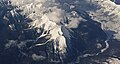
Gallery
Distant view looking north at Mt. Verendrye (center)
Aerial view of Mt. Wardle (centered), Mt. Verendrye (top, left) and Vermilion River (right)
↑Boles, Glen W. (2006). Mountain Place Names: The Rockies and Columbia Mountains. Rocky Mountain Books. p.260. ISBN978-1-894765-79-4.
↑MacLaren, I.S. (2005). Mapper of Mountains M.P. Bridgland in the Canadian Rockies 1902-1930. With Eric Higgs, Gabrielle Zezulka-Mailloux. Edmonton, AB: The University of Alberta Press. ISBN0-88864-456-6.
↑Peel, M. C.; Finlayson, B. L.; McMahon, T. A. (2007). "Updated world map of the Köppen−Geiger climate classification". Hydrol. Earth Syst. Sci. 11: 1633–1644. ISSN1027-5606.
This page is based on this Wikipedia article Text is available under the CC BY-SA 4.0 license; additional terms may apply. Images, videos and audio are available under their respective licenses.